Please join us Saturday October 22 as we recognize the 10th anniversary of Superstorm Sandy with a clean-up of the South River floodplain in South River and Sayreville.
In addition to the Lower Raritan Watershed Partnership we are grateful to our partner organizations including Middlesex County Department of Parks, the Reformed Church of South River, the Highland Park Ecology and Environmental Group, the Sayreville Environmental Commission, the South River Environmental Commission/Green Team, the South River High School, and the South River and Sayreville Public Works.
We will be working along the South River on both sides of the Causeway Bridge.
Parking information and additional details in the confirmation email.
On February 24, 2022 the Lower Raritan Watershed Partnership, Princeton Hydro and Middlesex County Office of Planning hosted a Virtual Outreach Session to share concept plan development for the restoration of a 165-acre coastal eco-park along the South River in New Jersey.
During this webinar project partners discuss ecosystem restoration; contextualize the site and its historic and current conditions; provide drone images of the site; and discuss proposed public access opportunities, recreational priorities, ecological enhancement (including identifying optimal nest platform locations for Osprey, Bald Eagles, and Peregrine Falcons), and more.
This project is supported through a $249,639 in National Fish and Wildlife Foundation grant to:
“Conduct an ecosystem restoration site assessment and design for 165 acres of tidal marshes and transitional forest in New Jersey’s Raritan River Watershed. Project will result in an engineering plan with a permit-ready design to reduce coastal inundation and erosion along about 2.5 miles of shoreline for neighboring flood-prone communities and enhance breeding and foraging habitat for 10 state-listed threatened and endangered avian species.”
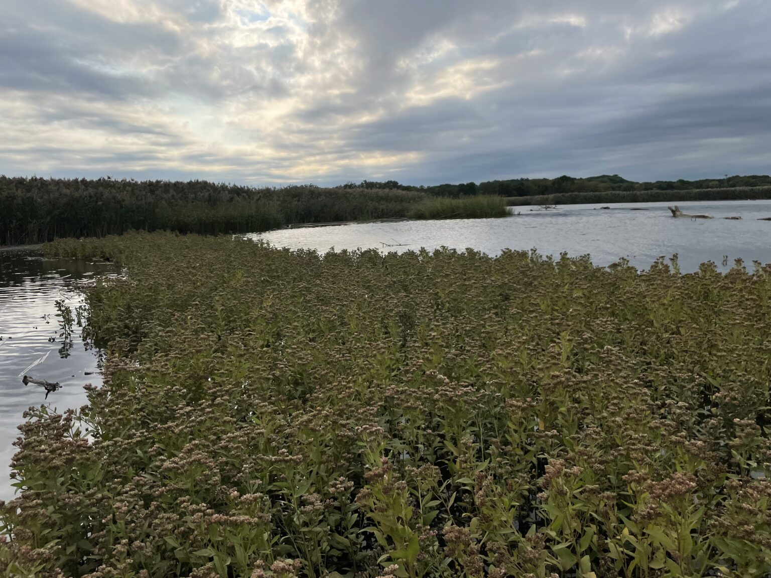
Just 50 miles southeast of New York City, tucked between two municipalities, sits a 650+ acre tidal salt marsh which spans the shorelines of the South River in densely populated, highly developed Central New Jersey. The South River is the first major tributary of the Raritan River, located 8.3 miles upstream of the Raritan River’s mouth, which drains into Raritan Bay.
The Lower Raritan River and Raritan Bay make up a large part of the core of the NY-NJ Harbor and Estuary Program. Within the Raritan Estuary, the South River wetland ecosystem is one of the largest remaining wetland complexes. While the South River salt marsh ecosystem has been spared from direct development, it has been degraded in quality, and does not provide optimal habitat for wildlife or maximum flood protection for residents. This area is subject to fairly regular tidal flooding (particularly when it occurs simultaneously with a storm) and periodic—generally more severe—flooding during more significant events such as nor’easters and tropical storms. Hurricanes Irene and Sandy caused damage in the Boroughs of Sayreville and South River too.
In 2018, Princeton Hydro and Rutgers University, along with the Lower Raritan Watershed Partnership, Middlesex County, Borough of Sayreville, Borough of South River, NY/NJ Baykeeper, Raritan Riverkeeper, and the Sustainable Raritan River Initiative, secured funding from NFWF’s National Coastal Resilience Fund for the “South River Ecosystem Restoration & Flood Resiliency Enhancement Project.”
The South River Ecosystem Restoration and Flood Resiliency Enhancement Project aims to:
Reduce socioeconomic damages to the Boroughs of South River and Sayreville caused by storm damage, flooding, and sea level rise;
Transform degraded wetlands to high-quality marsh that can reduce flooding and enhance fish & wildlife habitat; and
Engage stakeholders in activities about coastal resilience and ecological health to maximize public outreach in the Raritan River Watershed.
For this 165-acre tidal marsh and transitional forest “eco-park,” the project team is conducting an ecosystem restoration site assessment and design. This phase of the coastal restoration project will result in a permit-ready engineering design plan that stabilizes approximately 2.5 miles of shoreline, reduces flood risk for smaller coastal storms, and enhances breeding and foraging habitat for 10 state-listed threatened and endangered avian species.
Project Area History
This area has experienced repeated flooding, especially during large storms. For example, coastal areas of Sayreville and South River flooded after Hurricane Floyd (1999), Tropical Storm Ernesto (2006), Hurricane Irene (2011), and Hurricane Sandy (2012). Over the last century, there have been several studies and assessments completed for the South River, many of which identify this project area as a priority location for flooding improvements. The following are key reports and studies published about the project area and surrounding communities:
1930s
NJ Legislature’s 71st Congress published a report, “Basinwide Water Resource Development Report on the Raritan River Basin” which focused on navigation and flood control for the entire Raritan River Basin. It discussed recommendations for flood control and local storm drainage, setting the stage for future actions.
1970s
NJDEP Division of Water Resources published Flood Hazard Reports for the Matchaponix Brook System and Raritan River Basin, which delineated the floodplains in the South River, and its tributaries, the Manalapan Brook and Matchaponix Brook.
1980s
USACE New York District released a “Survey Report for Flood Control, Raritan River Basin,” which served as a comprehensive study of the Raritan River Basin and recommended several additional studies. Although the South River was studied, none of the proposed improvements were determined to be economically feasible at that time.
Project area was listed as one of the Nation’s Estuaries of National Significance.
1990s
USACE conducted a multi-purpose study of this area. This preliminary investigation identified Federal interest in Hurricane and Storm Damage Reduction and ecosystem restoration along the South River and concluded that a 100-year level of structural protection would be technically and economically feasible.
2000s
USACE NYD and NJDEP released a joint draft, “Integrated Feasibility Report and Environmental Impact Statement” for the South River, Raritan River Basin, which focused on “Hurricane & Storm Damage Reduction and Ecosystem Restoration.” Because it was previously determined that there were no widespread flooding problems upstream, the study area was modified to focus on the flood-prone areas within the Boroughs of Sayreville and South River, as well as Old Bridge Township.
Towards a More Resilient South River Ecosystem
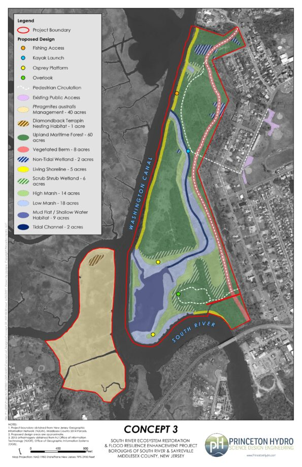
Through collaboration with our project partners and following input provided from a virtual stakeholder meeting held in December 2020, Princeton Hydro developed a conceptual design for an eco-park that incorporates habitat enhancement and restoration, and protective measures to reduce impacts from flooding while maximizing public access and utility. Public access includes trails for walking and designated areas for fishing. The eco-park can also be used for additional recreation activities such as bird watching and kayaking.
Highlights of the conceptual design include the following features:
Approximately two miles of trails with overlook areas, connection to fishing access, and a kayak launch.
~3,000 linear feet of living shoreline, located along portions of the Washington Canal and the South River, to provide protection from erosion, reduce the wake and wave action, and provide habitat for aquatic and terrestrial organisms.
~60 acres of enhanced upland forest to provide contiguous habitat areas for resident and migratory fauna.
A tidal channel that will connect to the existing mud flat on the southeastern part of the site and provide tidal flushing to proposed low and high marsh habitats along its banks.
A vegetated berm with a trail atop will extend the length of the site to help mitigate flood risk.
Two nesting platforms for Osprey, a species listed as “Threatened” in NJ
Designated nesting habitat for the Diamondback Terrapin, a species listed as “Special Concern” in NJ
The Lower Raritan Watershed Partnership and Rutgers Cooperative Extension of Middlesex County seek civic science volunteers to assist with the Summer 2019 “Citizen Science Monitoring for Pathogens Indicators on the Raritan River.” This program will run every Thursday from May 23 to September 26. Volunteers will travel with a monitoring team to capture water quality samples at sites along the Raritan River, followed by a trip to the NEIWPCC lab in Staten Island to assist with preparation of samples for analysis. A 2 hour training is required, after which the Project Team would like volunteers to commit to assisting with at least five (5) sampling events throughout Summer 2019.
The first training will be on Thursday May 9, 1-3:30 PM at the EARTH Center of Middlesex County. Registration required.
This project will allow us to gather data and other information on water quality for six public access sites along the tidal portions of the Raritan River at locations considered non-bathing beaches. In addition to capturing water samples at each of the six public access sites, volunteers will have the opportunity to go to the NEIWPCC’s lab on Staten Island to learn how samples are processed for monitoring.
We will monitor non-bathing beach sites with active kayak/canoe launches and/or fishing and other primary contact activities that are not regularly monitored by the New Jersey Department of Environmental Protection or the New Jersey Department of Health and Human Services and lack sufficient water quality data.
Bacteria data will be reported in “real-time” on Friday afternoons to allow Lower Raritan residents and others to make informed decisions about their on-water recreation activities for the weekend.
The Project will also allow for development of civic science and expanded volunteer environmental monitoring programming within the Lower Raritan Watershed and Middlesex County, NJ. Working with an approved Quality Assurance Project Plan (QAPP) will allow for data generated from this project to inform water quality policy and regulatory decisions at all levels of government (state, federal, local) within the project area, and to educate the public.
Water quality monitoring sampling will directly inform public access decision-making for six (6) diverse Lower Raritan Watershed municipalities (see site map below). These sites include:
Riverside Park (Piscataway)
Rutgers Boathouse at Boyd Park (New Brunswick)
Edison Basin Boat Launch (Edison Township)
Ken Buchanan Riverfront Park (Sayreville)
Raritan Bay Waterfront Park (South Amboy)
2nd Street / Brighton Avenue Beach (Perth Amboy)
Sites were chosen to inform decision-making about access and use, to aid understanding of municipal stormwater and sewage flows, and to inform current and future landuse planning and restoration efforts. Sites include the following known activities: 1) launch sites for personal non-motorized watercraft (sites 1-5); 2) fishing (sites 2-6); 3) birding hotspots (site 5); 4) crabbing (sites 2,4,5,6); 5) proximate to Combined Sewer Overflow (site 6); 6) unofficial bathing activity (sites 2,5,6); 7) collegiate watersport competition (site 2).
Generous support for equipment and data analysis is provided by the New England Interstate Water Pollution Control Commission.
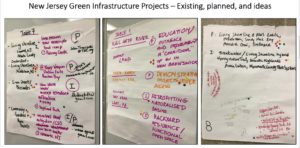
On November 17 the Lower Raritan Watershed Partnership joined with NOAA to co-host a day-long workshop: “Introducing Green Infrastructure for Coastal Resilience”. This workshop, designed for planners, engineers and municipal leaders not yet familiar with GI for coastal resilience, brought in more than 50 participants from the Lower Raritan Watershed and throughout New Jersey. It was a great event!
Workshop participants brainstorm ways to implement Green Infrastructure in their communities
Many thanks to everyone who joined us for the workshop, with special thanks to our speakers: Lauren Long (NOAA), Toby Horton & Jeremiah Bergstrom (Rutgers Cooperative Extension), John Trucsinski (The Nature Conservancy), Linda Weber (Sustainable Jersey) and Carter Craft (Consulate General of the Netherlands).
Tobiah Horton (Rutgers Extension), Lauren Long (NOAA) and Carter Craft (Consulate General of the Netherlands) discuss local resilience responses
The workshop was timed to coincide with the 5th anniversary of Superstorm Sandy. We saw this anniversary as an opportune moment to reflect on successes in implementing GI thus far, as well as to frame challenges, solutions and opportunities for future GI interventions. Of course this work is just beginning. The LRWP, NOAA and Rutgers Marine Sciences are discussing how to continue the conversation in 2018. Stay tuned! For now, please see conference handouts, presentations, and additional resources below.
Come out and help Middlesex County Conservation Corps and Clean Ocean Action keep our shores beautiful and debris-free in this annual event held on the Raritan Bay Waterfront! Supplies provide. Registration required. Please contact Griffith Boyd #732.746.3064 or griffith.boyd@co.middlesex.nj.us to RSVP and for more information.