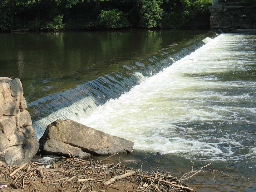
The Nevius Street Dam at Raritan River Mile 27.0 was located just south of the Borough of Raritan, Somerset County, New Jersey. This dam, also referred to as the “Duke Dam,” was constructed in 1901 by James Buchanan (Buck) Duke, the tobacco and hydropower industrialist, for aesthetic and recreational purposes as part of his development of Duke Farms, a 2,740-acre estate in Hillsborough Township, New Jersey. Careful examination of the dam indicated that it was constructed of dressed stone blocks arranged in a stair-step fashion set into a concrete core foundation that was 195 feet long, approximately 2.5 feet high from sill to crest, and approximately 6.5 feet in width. The picturesque dam and dam impoundment were often photographed in its early years, and some of these photographs were reproduced in the book Raritan [NJ] – Images of America, published in 2003.
The Nevius Street Dam was subsequently converted into an essential part of the Duke Farms water supply system when water pumping withdrawals from the adjacent Raritan Water Power Canal were discontinued in the early 1970s (this Canal water supply system was the original source of water that was pumped up to Duke Farms for irrigation and for circulation through a series of man-made lakes and waterfalls). This conversion was accomplished by retrofitting a water intake grate on the north side of the dam, and installing a 205-foot long, 30-inch diameter concrete reinforced pipeline that conveyed surface water downriver into a subterranean chamber under the Duke Farms Powerhouse building, which was then pumped up to the Duke Farms reservoir (from there, the water cascaded through the numerous lakes and waterfalls on the property). This modification allowed Duke Farms to utilize the same infrastructure that had previously provided both hydroelectric power and water supply to the property, although now that the surface water was flowing into the river-level penstock of the Powerhouse rather than falling from a substantial height from the Raritan Water Power Canal, the turbines of the Powerhouse were bypassed and, thus, fell silent.
In the runup to its removal, the Nevius Street Dam was still providing a vital service and with the pending removal of the dam, Duke Farms would be without a water supply for their renowned lake system. As part of the arrangement to remove the dam, I performed a hydrogeological study at the property in 2012 to determine if new groundwater supply wells could be installed to replace the Raritan River surface water supply. This alternative proved to be feasible, although it would not be possible to replace the approximately 750,000 to 1 million gallons that was typically pumped up to the Duke Farms reservoir each day. The tradeoff of a lower volume of groundwater was that the groundwater would be free of high concentrations of total phosphorus, ammonia-N, and nitrate-N that are present in the Raritan River, an impairment caused by runoff of fertilizer and manure from agricultural fields, suburban lawns, and golf courses. The Duke Farms Natural Resources team were expectant that the introduction of groundwater without excess nutrients might curtail the growth of curly-leaf pondweed and filamentous mat algae that has afflicted the lakes in the modern era.
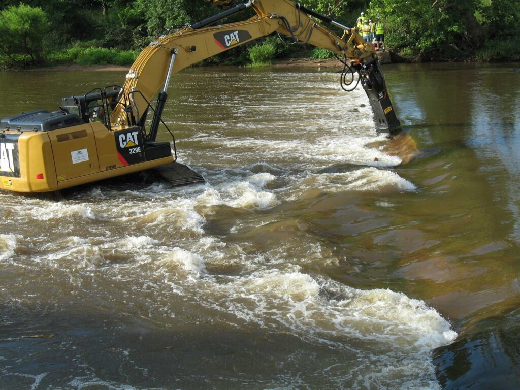
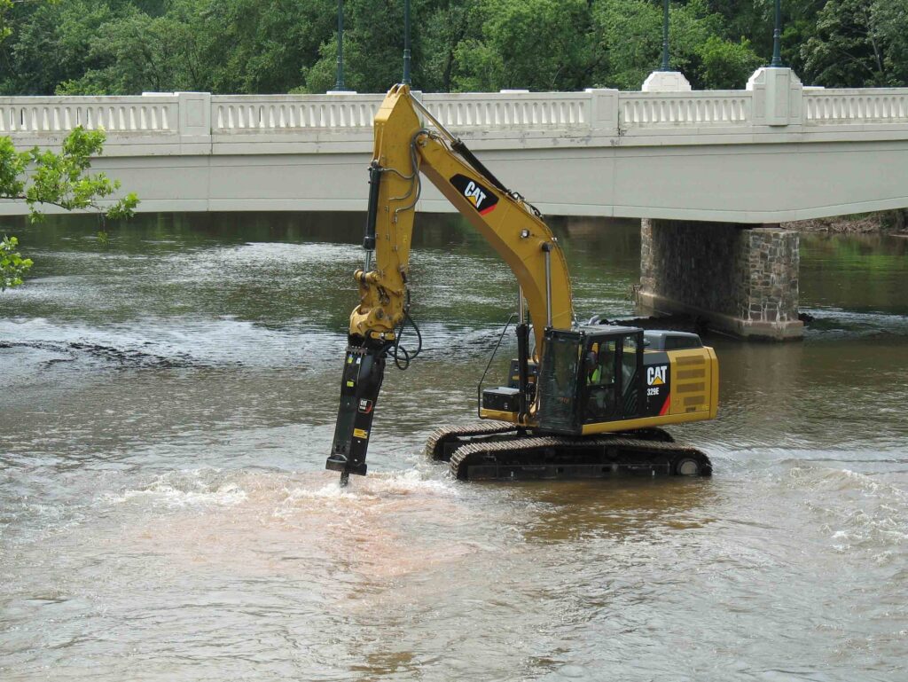
The installation of two groundwater water supply production wells was conducted in 2012 and 2016 and befitting Duke Farms’ commitment to the concept of “adaptive reuse,” I and the Duke Farms team conceived of a plan to repurpose underground pipelines that were built in 1909-1910 to connect the new production wells to the reservoir rather than excavate and install thousands of feet of new pipeline through the beautiful and pristine landscape of the property. Detailed analyses of an original 1911 as-built construction drawing revealed an elaborate underground pipeline network not only leading from the Powerhouse to the reservoir that the current dam pumping system was utilizing, but also a second, intertwined pipeline network that formerly conveyed water from a long-lost Recirculation Plant along the Raritan River that had recovered water after it had flowed through the lake system and recirculated it back to the reservoir. This pipeline was relocated in the field, flushed along its re-purposed length to remove accumulated sediment from its original operation, had its various values replaced, and was then connected to the new groundwater well field. This reconfiguration of the water supply system has proven to be a great success and it allowed for the removal of the Nevius Street Dam, which was accomplished between July 24-July 31, 2013.
Nevius Street Excavator – Initial BreachNevius Street Excavator – Final Breach
In closing, I would like to acknowledge former Executive Director Michael Catania, Jon Wagar (Deputy Director), and Thom Almendinger (Director of Natural Resources and AgroEcology), and the Doris Duke Charitable Foundation Board for their cooperation and consent to remove the Nevius Street Dam. Implementing this consequential water supply exchange from surface water to groundwater was not without risk so I am truly grateful for their trust, financial support, and steadfast resolve to implement this project, proving yet again that Duke Farms is a leader in environmental stewardship and an inspiration for citizens to become informed stewards of the land.
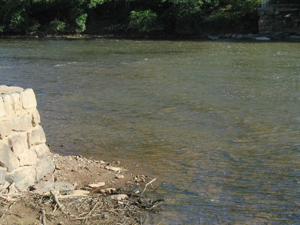
Nevius Street Dam After Removal
John W. Jengo, PG, LSRP is a licensed Professional Geologist in several Northeastern and Southeastern states and a Licensed Site Remediation Professional in New Jersey. John works as a Principal Hydrogeologist in an environmental consulting firm in southeastern Pennsylvania. He has degrees in geology from Rutgers University (1980) and the University of Delaware (1982). Over the last 30 years, he has conducted the characterization and remediation of large, complex contaminated industrial sites throughout New Jersey, Pennsylvania, and Delaware. He played a key role in Natural Resource Damage (NRD) assessments that led to groundbreaking legal settlements to remove numerous low head dams on the Raritan and Millstone Rivers to restore historically significant migratory fish spawning runs. As technical project manager, he planned, permitted, and successfully managed the removal of the Calco Dam, the Robert Street Dam, and the Nevius Street Dam between 2008-2013, and the removal of the Weston Mill Dam on the Millstone River in 2017, along with leading the archaeological investigation of the former Weston Mill in the Borough of Manville and Franklin Township.
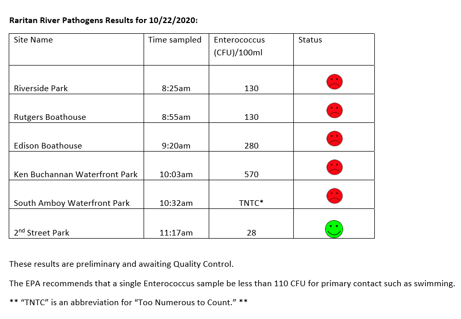
The LRWP and Rutgers Cooperative Extension of Middlesex County monitor for Fecal Coliform and Enterococcus at six non-swimming public beach access sites along the Lower Raritan during the warmer summer months. Fecal Coliform and Enterococcus are indicators of disease-causing bacteria in our waterways.
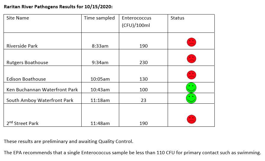
The EPA recommends that a single Enterococcus sample be less than 110 Colony Forming Units (CFU)/100mL for primary contact. Enterococci levels are used as indicators of the possible presence of disease-causing bacteria in recreational waters. Such pathogens may pose health risks to people fishing and swimming in a water body. Sources of bacteria include Combined Sewer Overflows (CSOs), improperly functioning wastewater treatment plants, stormwater runoff, leaking septic systems, animal carcasses, and runoff from manure storage areas. Enterococci levels are often high after heavy or consistent rainfall.
Below are our pathogens results for October 22, 2020.
Field notes for October 22, 2020
Fog blanketed much of the East Coast through the morning, and hung heavy over the Raritan until burning off around noon. Called “advection fog,” the mist forms when warm, moist air passes over a cool surface. Advection describes the movement of fluid, in this case the fluid is wind. When the moist, warm air made contact with the cooler surface air, water vapor condensed to create fog.
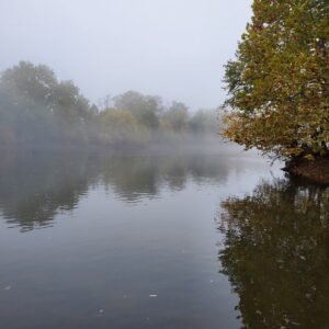
A blanket of fog hovered over our monitoring sites, including Riverside Park in Piscataway
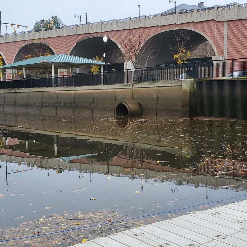
Ever wonder how all the rain that falls onto a highway is “disappears” for a safe driving experience? It is transferred via stormwater infrastructure — that is, pipes or channels — to and “outfall” at which the stormwater enters receiving waters (rivers, streams, or creeks). This outfall at New Brunswick’s Boyd Park conveys rainwater from Route 18 (above the arches) into the Raritan River at the Rutgers Class of 1918 Boathouse.
A stormwater outfall conveying water off of Route 18 into the Raritan River at Rutgers Boathouse.
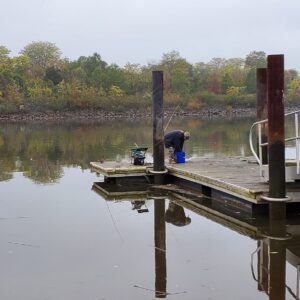
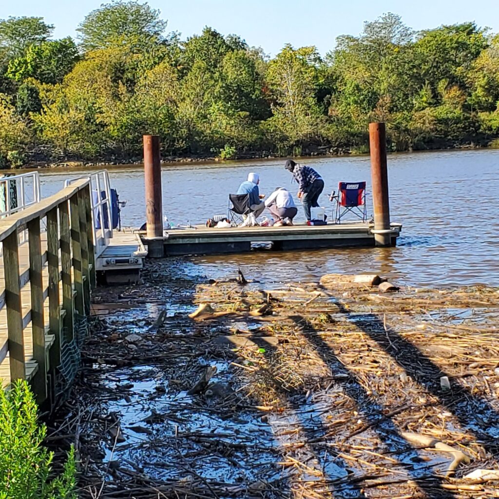
Our fisher friends in Edison didn’t seem to mind the fog. They told us they had just caught and released a 26-inch striper the night before.
The LRWP and Rutgers Cooperative Extension of Middlesex County monitor for Fecal Coliform and Enterococcus at six non-swimming public beach access sites along the Lower Raritan during the warmer summer months. Fecal Coliform and Enterococcus are indicators of disease-causing bacteria in our waterways.
The EPA recommends that a single Enterococcus sample be less than 110 Colony Forming Units (CFU)/100mL for primary contact. Enterococci levels are used as indicators of the possible presence of disease-causing bacteria in recreational waters. Such pathogens may pose health risks to people fishing and swimming in a water body. Sources of bacteria include Combined Sewer Overflows (CSOs), improperly functioning wastewater treatment plants, stormwater runoff, leaking septic systems, animal carcasses, and runoff from manure storage areas. Enterococci levels are often high after heavy or consistent rainfall.
Below are our pathogens results for October 15, 2020.
Field notes for 10.15.2020
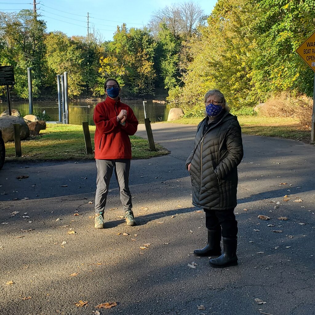
What a beautiful day for monitoring! Americorps Watershed Ambassador Caitlin DiCara helped us out with monitoring. We were also joined at our Piscataway and New Brunswick sites by our Windows of Understanding 2021 artist Marcia Shiffman. Marcia’s work for 2021 will focus on communicating the “hidden” social justice issue of inequitable access to nature.
Caitlin DiCara and Marcia Shiffman at our Riverside Park (Piscataway) site
We talked with Marcia and Caitlin about social barriers and physical obstacles to enjoyment of blue or green spaces or parks. In preparation for our listening session on Social Justice and Access to Nature, we identified a number of barriers to accessing nature. All of the below we observe as issues at non-bathing public access beach pathogens monitoring sites. These include:
-Difficulty in accessing green/blue or park space because of landscape design
-Difficulty in accessing green/blue or park space because of cost
-Not feeling welcome in a natural blue/green space or park because of economic status, or ethnic or cultural difference
-Cultural and/or language restriction present other barriers to enjoyment of time in natural spaces
-Bullying behaviors or material obstacles limit enjoyment of time in natural spaces for persons with disabilities
-Fear, anxiety, or feelings of helplessness in the face of crime limits time in natural spaces
What obstacles or barriers have we missed?
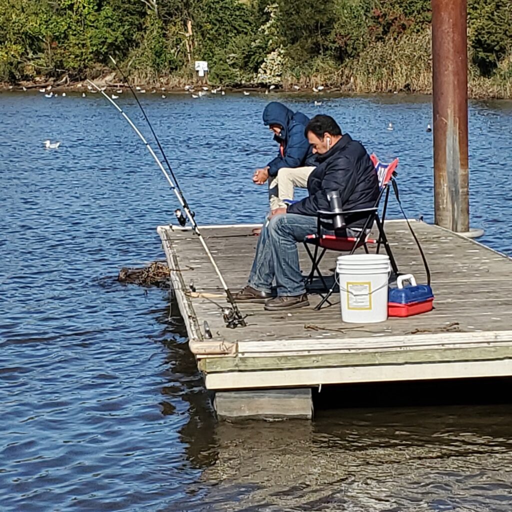
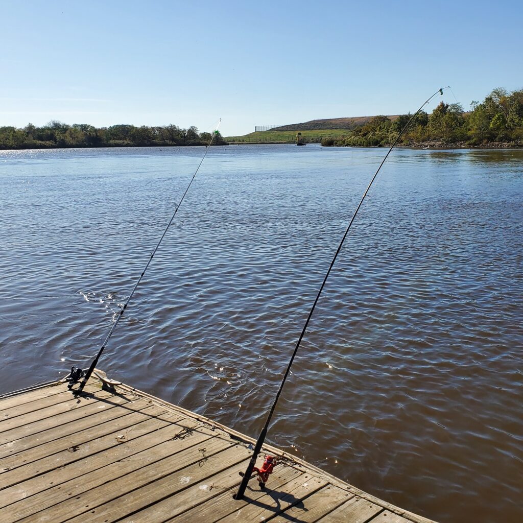
Our Thursday “regulars” fishing at the Edison Boat LaunchNot much tugging at these poles, Edison Boat Launch 10.15.2020
Article by Anjali Madgula, written as part of the Rutgers Spring Semester 2020 Environmental Communications course.
Anjali’s article was written to be shared on World Ecology and Ecologists Day, celebrated annually on November 1. World Ecology and Ecologists Day reminds people of the importance of knowing and valuing the relationships that exist between living beings and their environment, and raises awareness among our people about the importance of maintaining a harmonious relationship with our environment. Anjali’s piece was inspired by the way The Overstory by Richard Powers describes people connecting with nature while being informative, and inspiring environmental advocacy. Narrated from the point of view of the Raritan River itself, this piece piece details the work of the local community along the Raritan and connections between the people and soil, species, and water of the Raritan Watershed.
“The best arguments in the world won’t change a person’s mind. The only thing that can do that is a good story.”
They grew themselves amongst trees and concrete. Painting and playing on both bark and pavement. The young ones running around the city, mapping out their neighborhood, smiling curiously at their happy natural counterparts: the ever growing trees and plants tracing along their route to school. The bright-eyed young ones are the future caretakers of this community but I worry about the uncertain future we will inherit together.
Loss
In 2012, 1 billion gallons of sewage overflow discharged into my waters. I cannot safely provide for my ecosystem or the creatures who rely on me for sustenance anymore. This has grave and dire consequences for our community. I’ve felt damaged, toxic, polluted, and dangerous for as long as I can remember. I saw firsthand the horrors of pollution and how endless the cycle of poisoning can be till living things die in the hands of each other.
Our Shared Ecosystem
But, then people began to organize, to investigate and empower. They are Streamkeepers, community leaders, volunteers, students, and creatures of this ecosystem leading not only towards restoration but a totally new and reimagined mode of coexistence and value. They have promised to never forget how easy it is to destroy ecosystems.
Education
In school, they now teach the young ones about me. They learn about protecting each other and preserving nature. They illustrate and recognize the most endangered species in close proximity to them- species like the Blue Spotted Salamander and Red Tailed Hawk. The educators and students have a big ask. To learn from the past and to in essence, relearn the relationship between humans and nature. They know that the implications can be incredible when we empower beautiful futures in classrooms.
Art
#Lookfortheriver! They wrote this phrase on pavements, on posters- they made art, and built solidarity around my persistence to live on. They made understanding of sea level rise and urban flooding accessible to all through their social movement. They built streamside sculptures and paid homage to the hidden streams and impacts of climate change on local floodplains. They asked the community to see for themselves to create their own perspective and become civic scientists. They organized clean ups and displayed the valiant act of human hands working together and removing pieces of trash through sculpture as a testament to our community’s stewardship.
Resilience
I feel visible again as people in their homes and streets dream of me and sing to me. They study me, and create visions of my strength and resilience. They anticipate the dangerous need to prepare for the impacts of climate change, sea level rise, and future storms as a coastal community. They build and build coalitions to change infrastructure and dream of clean accessible water and a world without pollution. We look to each other in doing so and promise to never pollute the world with hate and injustice, to let all living things be free and respected. We remember the past in order to create something better.
Effective communication about the environment is critical to raising awareness and influencing the public’s response and concern about the environment. The course Environmental Communication (11:374:325), taught by Dr. Mary Nucci of the Department of Human Ecology at Rutgers University, focuses on improving student’s writing and speaking skills while introducing students to using communication as a tool for environmental change. Students not only spend time in class being exposed to content about environmental communication, but also meet with communicators from a range of local environmental organizations to understand the issues they face in communicating about the environment. In 2019 and 2020, the course applied their knowledge to creating blogs for their “client,” the Lower Raritan Watershed Partnership (LRWP). Under the guidance of LRWP Founder, Dr. Heather Fenyk, students in the course researched topics about water quality and recreation along the Raritan. Throughout 2020 the LRWP will share student work on our website.
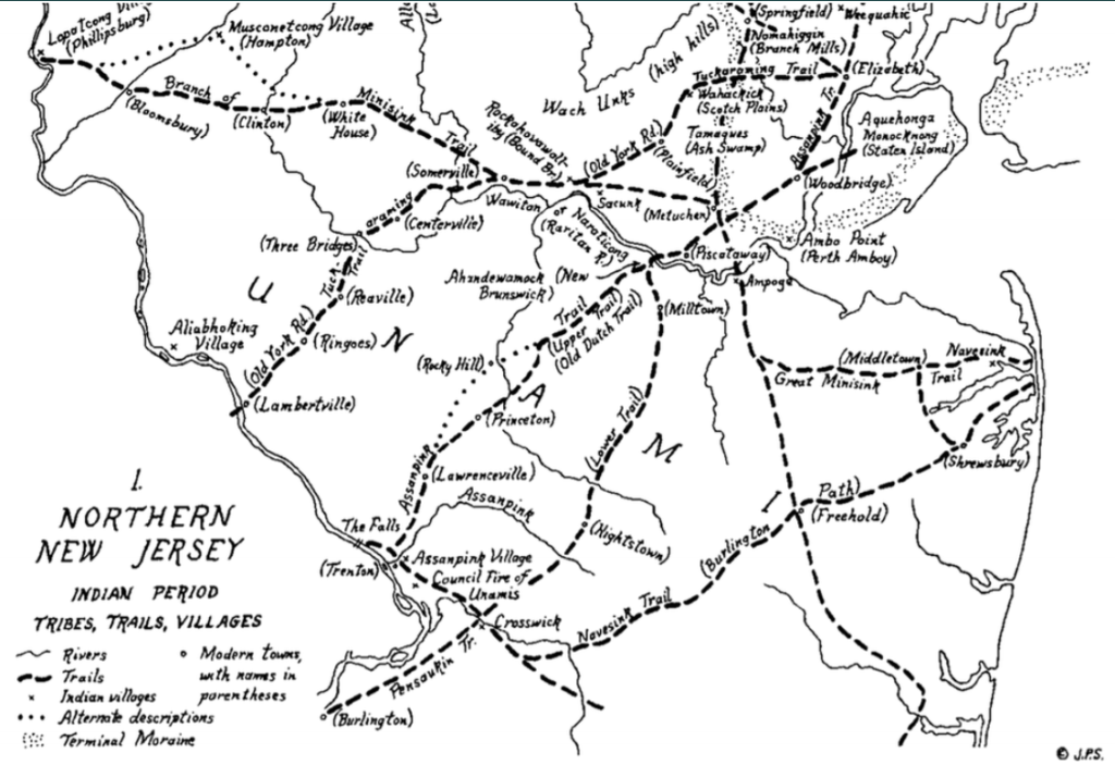
Today we celebrate Indigenous Peoples’ Day, with many state and other offices recognizing the holiday as Columbus Day. In rethinking how we celebrate American history, we reflect on the original people of our watershed: the Algonquin, known as Lenni Lenapi (Lenape). The tribal name Lenape can be translated from the Algonquin language, to mean “Original People or True People”.
One of the most famous historic trails is the Assunpink, which derives its name from the Algonquin word Ahsën’pink – meaning “stony, watery place.” This trail traced a path between the Delaware River in south and the Raritan River in the north. Now a roadway system, the Assunpink has served as a route linking Philadelphia and Perth Amboy for European settlers and their descendants. George Washington used the trail during the American Revolution. Names attributed to it have included: the Old Dutch Trail, The King’s Highway, Lincoln Highway, and Route 27.
For a fun day trip you might consider tracing the historic Assunpink Trail or the nearby East Coast Greenway by foot or bike!
Photos and article by LRWP Board President Heather Fenyk
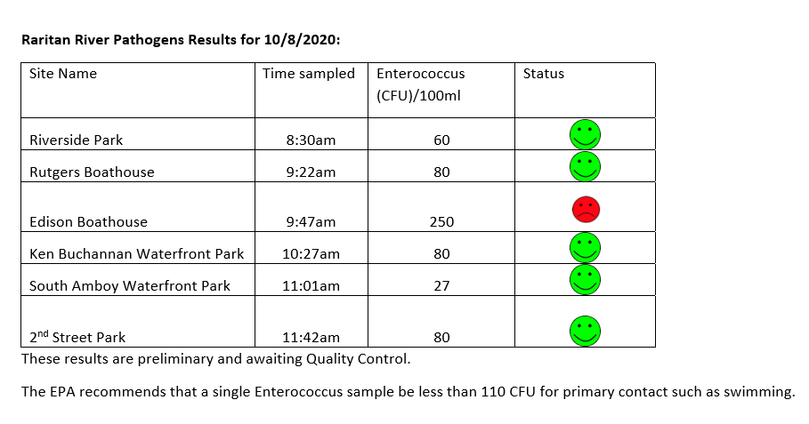
The LRWP and Rutgers Cooperative Extension of Middlesex County monitor for Fecal Coliform and Enterococcus at six non-swimming public beach access sites along the Lower Raritan during the warmer summer months. Fecal Coliform and Enterococcus are indicators of disease-causing bacteria in our waterways.
The EPA recommends that a single Enterococcus sample be less than 110 Colony Forming Units (CFU)/100mL for primary contact. Enterococci levels are used as indicators of the possible presence of disease-causing bacteria in recreational waters. Such pathogens may pose health risks to people fishing and swimming in a water body. Sources of bacteria include Combined Sewer Overflows (CSOs), improperly functioning wastewater treatment plants, stormwater runoff, leaking septic systems, animal carcasses, and runoff from manure storage areas. Enterococci levels are often high after heavy or consistent rainfall.
Below are our pathogens results for October 8, 2020. These are some of the best results of the season so far!
Please note: results are preliminary and pending quality control.
Field notes for 10.8.2020
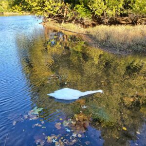
Every Thursday morning for the past 10 weeks of monitoring we have been greeted by a pair of mute swans at our Piscatway Riverside Park monitoring site. Although Mute Swans are not native to our area, and their aggressive behavior and voracious appetites disturb local ecosystems and displace native species, they are known to mate for life and these two seemed to have a special bond. It was a sad sight to find one of the pair floating along the dock this morning, it’s partner just a few yards away.
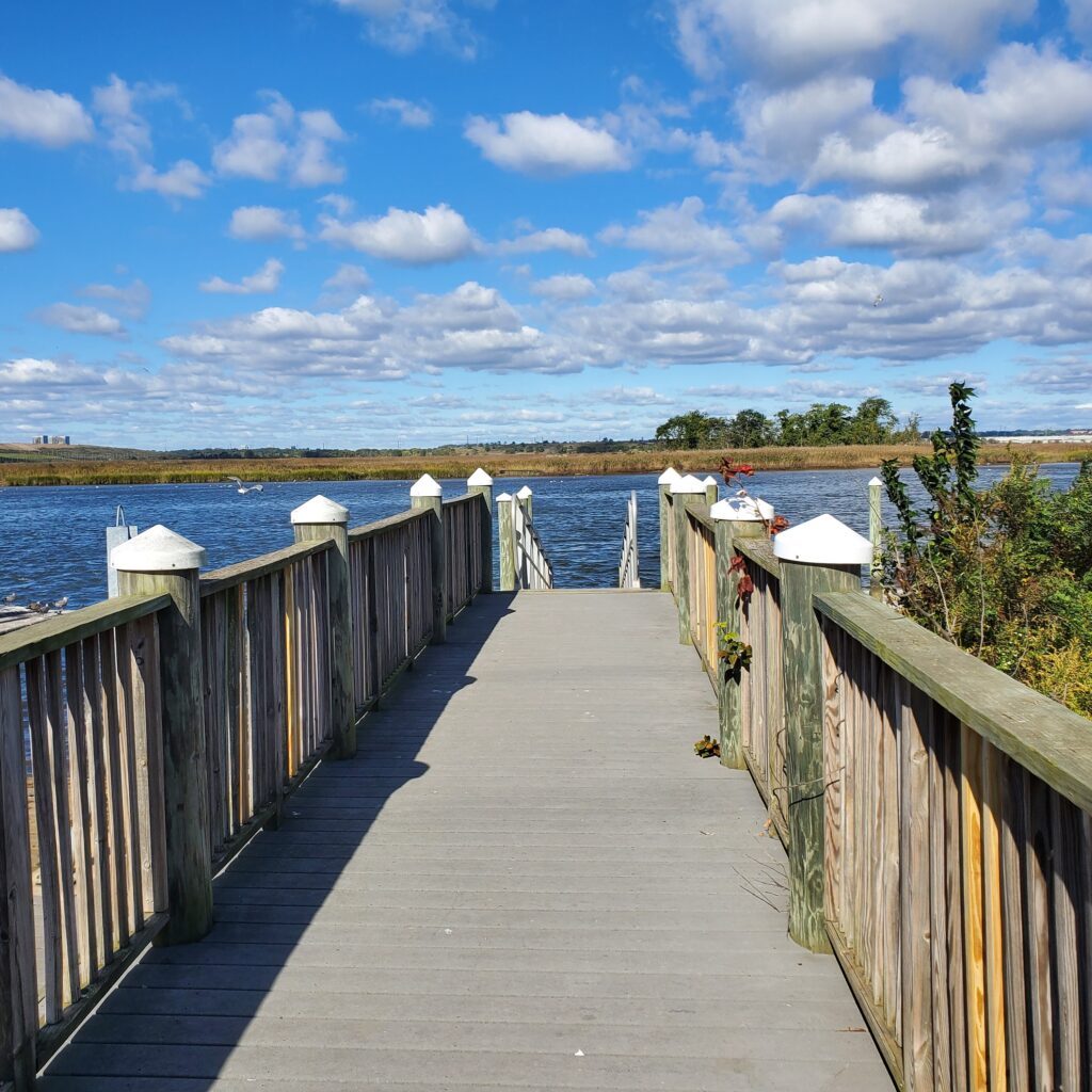
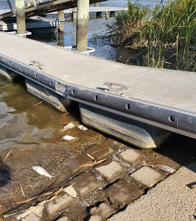
Things didn’t get much better, with fish kills at our Edison and Sayreville sites. The gorgeous view off one of the Ken Buchanan docks belied the mess in the water.
One of the docks at the Ken Buchanan Sayreville site.A few of the dozens, if not hundreds, of dead fish in the Raritan at Sayreville 10.8.2020
Interview by Emily Koai, LRWP Spring 2020 Raritan Scholar
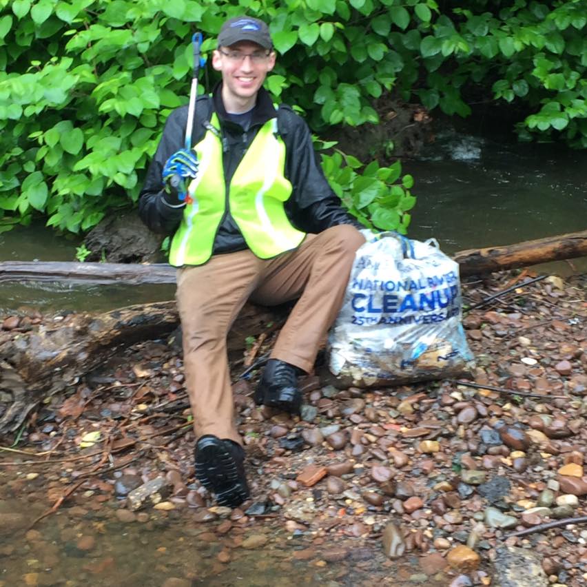
Anton Getz, LRWP’s newest board member, is a Mapping Specialist with Michael Baker International, where he is the GIS Lead, Project Manager, and Instructor for their Floodplain Management Division. Volunteers for LRWP’s stream clean-ups will likely remember Anton as the fellow “in the water” during our events, where he helps strategize safe removal of large items from our streams. Anton has a background in geography, and is passionate about environmental stewardship and sustainability, natural resource conservation, clean water advocacy, sustainable land use, historic preservation, and local food systems.
LRWP Board Member Anton Getz at a stream clean-up – his natural habitat!
EK: Could you tell us a little about yourself and your background?
AG: I have lived in the Lower Raritan Watershed my whole life. I went to Rutgers and studied Geography, and now work on flood hazard mapping, mitigation, and risk communication for a living. I have a love and appreciation for nature and the outdoors and have a known bad habit of taking too many outdoorsy photos. I’m also an animal person and have always had dogs as a companion.
EK: Did you have any passion projects in your career that led you to where you are today?
AG: I have been doing consulting work for FEMA’s National Flood Insurance Program for over a decade. This work is mostly focused on floodplain mapping, but also includes working on regulations, insurance implications, and hazard mitigation. The FEMA program has helped me see how our land development patterns have gravitated towards water over time. Serious flood hazard exist that are not obvious to normal folks on a day-to-day basis. It is so difficult to successfully communicate data, hazards, and risks to people! This work has shown how interdisciplinary water issues are—public safety, environmental health, public policy, economic activity, and social “sense-of-place” all play a role in our relationship with water.
EK: How has working with the LRWP helped enhance your personal goals for the watershed?
AG: I have been doing cleanups with LRWP for few years and joined the board earlier in 2020. We had a full slate of event-planning for the year until COVID-19 hit. So, I would say goals and progress have been slowed for the moment, but I hope that I can help grow the cleanup program, recreational activities, and donor support.
EK: How have you encouraged engagement with the watershed in your community?
AG: I’m more of a doer than a talker. I stay late at cleanups! Sometimes to the dismay of the organizers…and I work hard. Perhaps you can call it inspiration through action.
EK: Why are stream cleanups important with regard to community engagement?
AG: Stream cleanups personalize the impact of our collective human activities. We can be very insulated from the full life cycle of our consumption choices—not seeing where our stuff came from or where it goes after we are done with it. Doing a stream cleanup sheds lights on the question of where it goes, and even where it came from. “Why are there so many pieces of Styrofoam coffee cups in the river? How did a municipal recycling bin get into the river? Why are there plastics bottles filled with pee in the rivers?” With this knowledge, communities can make informed decisions about collective and personal activities. Do they want to zone and approve more businesses that produce single-use litter in their towns? Will individuals choose to purchase more package-less food from a farmer’s market? And so on.
EK: How do you see this work progressing in the future?
AG: We were trending towards and starting to plan more cleanups and more community events with growing and diversified engagement. The LRWP has certainly impressed me with its ability to attract and engage a really diversified group of supporters and volunteers. However, uncertainty has descended upon us with the COVID-19 outbreak. When and how we return to community events is unknown at this point. I hope it does not discourage turnout when we do start to resume activities, but perhaps instead inspires people to act more locally on behalf of the health of the environment and people.
EK: What is your message to anyone that wants to be more engaged?
AG: I am relatively new to the environmental non-profit world in terms of taking action beyond what I do on my own, at home, such as limiting water and energy usage, eating locally, taking care of material items so they last, etc. So it’s never too late to start. My advice would be to find a cause you believe in, talk to people involved with that cause, ask questions, and volunteer your time. It will open up doors.
Photos and article by LRWP Board President Heather Fenyk
The LRWP and Rutgers Cooperative Extension of Middlesex County monitor for Fecal Coliform and Enterococcus at six non-swimming public beach access sites along the Lower Raritan during the warmer summer months. Fecal Coliform and Enterococcus are indicators of disease-causing bacteria in our waterways.
The EPA recommends that a single Enterococcus sample be less than 110 Colony Forming Units (CFU)/100mL for primary contact. Enterococci levels are used as indicators of the possible presence of disease-causing bacteria in recreational waters. Such pathogens may pose health risks to people fishing and swimming in a water body. Sources of bacteria include Combined Sewer Overflows (CSOs), improperly functioning wastewater treatment plants, stormwater runoff, leaking septic systems, animal carcasses, and runoff from manure storage areas. Enterococci levels are often high after heavy or consistent rainfall.
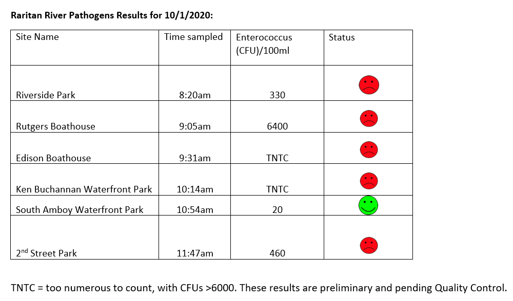
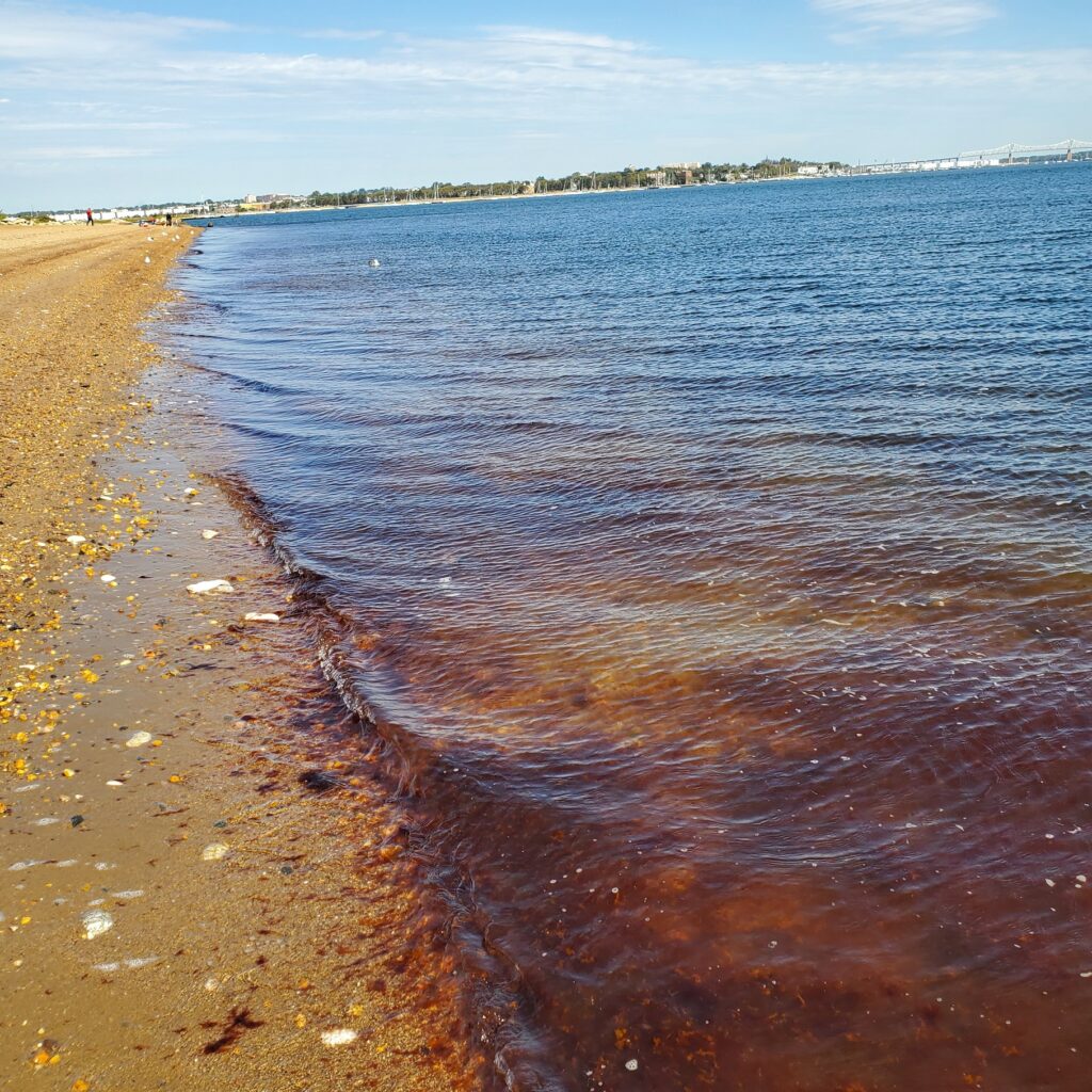
Below are our pathogens results for October 1, 2020. These are about the worst results of the season so far. Two of our sites had colony forming units (cfus) that were TNTC or “too numerous to count”.
Please note: results are preliminary and pending quality control.
Field Notes for 10.1.2020
Our sites may be “dirty” but they are also beautiful, and places where many go for fishing, recreation, and to learn more about the natural and constructed world.
Gorgeous views at our Riverside Park (Piscataway) site belie what are typically our worst pathogens counts for all monitored sitesOur friends at the Edison Boat launch site told us the water was too dirty to catch anything but eels. LOTS of trash floating in the water at this site this week.This is the fifth week of red tide conditions at our monitoring site in South Amboy
Check out the video we capture of a simultaneous train crossing of the picturesque Raritan River “River Draw” in Perth Amboy!
Photos and article by LRWP Board President Heather Fenyk
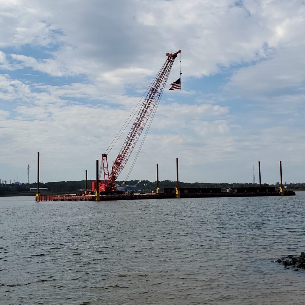
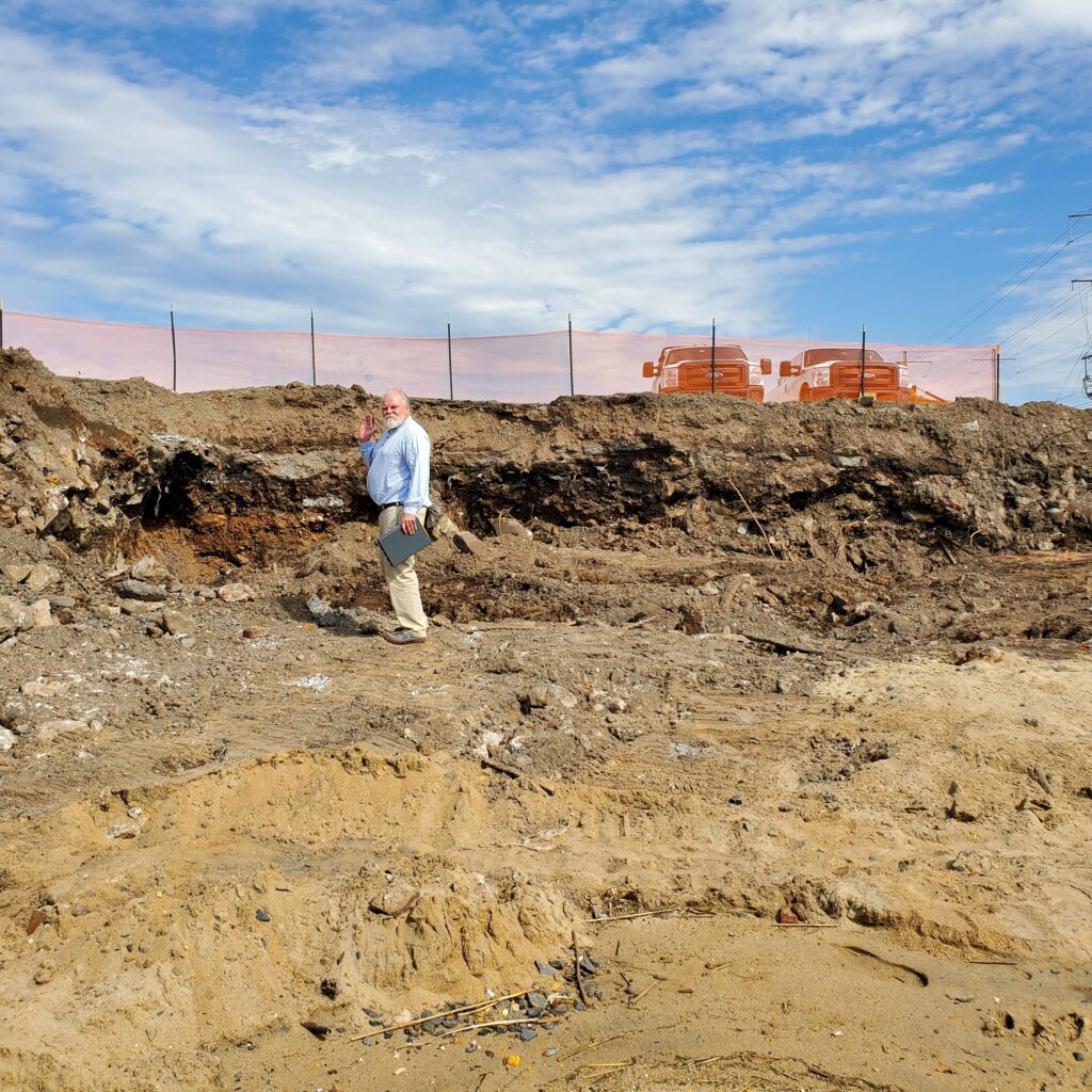
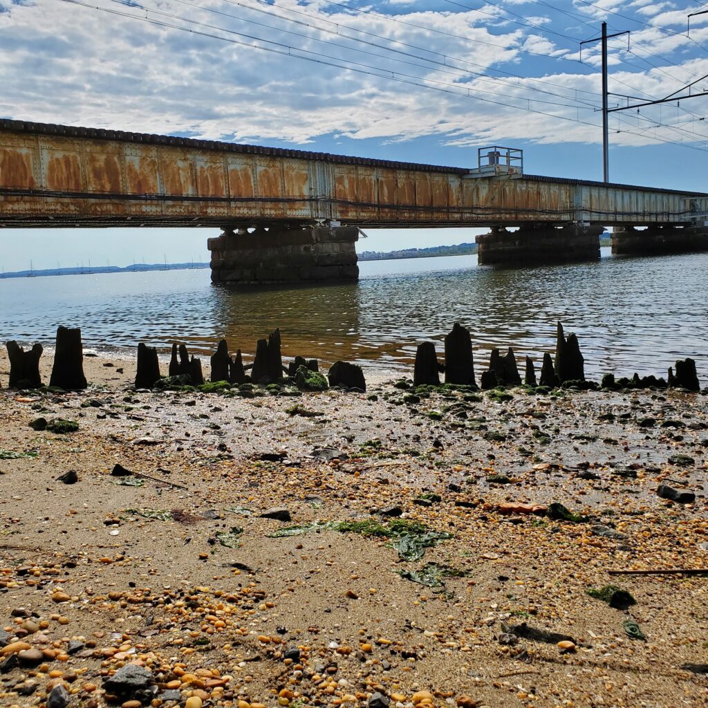
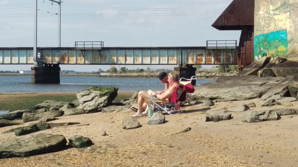
The last several weeks of pathogens monitoring in Perth Amboy have given us a front seat view of in-water preparations for the Raritan River Bridge replacement project. The bridge replacement project entails construction of a new drawbridge on New Jersey Transit’s North Jersey Coast Line, spanning the mouth of the Raritan River between the city of South Amboy and the city of Perth Amboy, west of the existing bridge. The ceremonial “groundbreaking” was September 15, and the crew is now working on the project in earnest.
Bridge replacement work will include providing a 300-ft-wide lift channel for boats, as well as demolition of the existing bridge following completion of the new bridge. The existing movable bridge, a swing span built in 1908 and known as River Draw, sustained significant damage during Superstorm Sandy in 2012 when it was struck by a runaway tugboat, shifting it on its pilings and requiring emergency repair before being placed back in service. The overall project cost is $595 million, and the new bridge will integrate resilient structural designs and materials to withstand future storm surges and be significantly less vulnerable to severe weather events.
Video of crossing of east bound and west bound trains on River Draw 10.1.2020Work barge making preparations for a new Railroad Bridge in Perth AmboyLRWP Board Member Alex Zakrewsky at Raritan Rail Bridge excavation siteRiver Draw train bridge, Perth AmboyThe River Draw in view of a Combined Sewer Overflow at Perth Amboy’s 2nd Avenue
What Do the Stormwater Management Rules Mean for My Town?
Webinar Hosted by Monmouth County Division of Planning
Thursday, Oct 15, 2020 10:00 am | 1 hour 30 minutes | Eastern Time (US & Canada)
This spring, NJDEP adopted the amended Stormwater Management Rules which are set to take effect in March 2021. The Rules require new major developments to manage stormwater with green infrastructure and require municipalities to revise their municipal stormwater control ordinances. To help engineers and municipalities understand and implement the new rules, the Monmouth County Division of Planning is hosting a webinar with presenter Gabe Mahon, Bureau Chief of NJDEP’s Bureau of Nonpoint Pollution Control. After the presentation, there will be an opportunity for Q&A. The event will take place via WebEx on October 15 at 10 a.m. You do not need to register for this event. Just join the meeting using the link below at the scheduled time. Questions can be directed to Bridget.Neary@co.monmouth.nj.us or Amber.Mallm@co.monmouth.nj.us.