Designing an Eco-Park Along the South River
By Johnny Quispe, Ph.D., LRWP Board Member and Princeton Hydro Ecosystem Restoration Project Lead
Learn more about this project during our February 24, 6:30-8pm Webinar!
Just 50 miles southeast of New York City, tucked between two municipalities, sits a 650+ acre tidal salt marsh which spans the shorelines of the South River in densely populated, highly developed Central New Jersey. The South River is the first major tributary of the Raritan River, located 8.3 miles upstream of the Raritan River’s mouth, which drains into Raritan Bay.
The Lower Raritan River and Raritan Bay make up a large part of the core of the NY-NJ Harbor and Estuary Program. Within the Raritan Estuary, the South River wetland ecosystem is one of the largest remaining wetland complexes. While the South River salt marsh ecosystem has been spared from direct development, it has been degraded in quality, and does not provide optimal habitat for wildlife or maximum flood protection for residents. This area is subject to fairly regular tidal flooding (particularly when it occurs simultaneously with a storm) and periodic—generally more severe—flooding during more significant events such as nor’easters and tropical storms. Hurricanes Irene and Sandy caused damage in the Boroughs of Sayreville and South River too.
In 2018, Princeton Hydro and Rutgers University, along with the Lower Raritan Watershed Partnership, Middlesex County, Borough of Sayreville, Borough of South River, NY/NJ Baykeeper, Raritan Riverkeeper, and the Sustainable Raritan River Initiative, secured funding from NFWF’s National Coastal Resilience Fund for the “South River Ecosystem Restoration & Flood Resiliency Enhancement Project.”
The South River Ecosystem Restoration and Flood Resiliency Enhancement Project aims to:
- Reduce socioeconomic damages to the Boroughs of South River and Sayreville caused by storm damage, flooding, and sea level rise;
- Transform degraded wetlands to high-quality marsh that can reduce flooding and enhance fish & wildlife habitat; and
- Engage stakeholders in activities about coastal resilience and ecological health to maximize public outreach in the Raritan River Watershed.
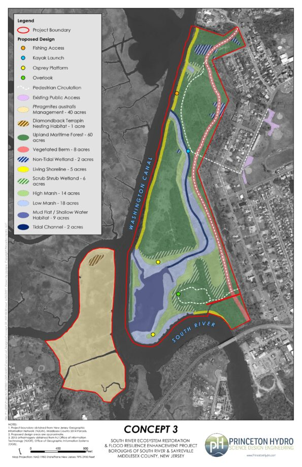
For this 165-acre tidal marsh and transitional forest “eco-park,” the project team is conducting an ecosystem restoration site assessment and design. This phase of the coastal restoration project will result in a permit-ready engineering design plan that stabilizes approximately 2.5 miles of shoreline, reduces flood risk for smaller coastal storms, and enhances breeding and foraging habitat for 10 state-listed threatened and endangered avian species.

Project Area History
This area has experienced repeated flooding, especially during large storms. For example, coastal areas of Sayreville and South River flooded after Hurricane Floyd (1999), Tropical Storm Ernesto (2006), Hurricane Irene (2011), and Hurricane Sandy (2012). Over the last century, there have been several studies and assessments completed for the South River, many of which identify this project area as a priority location for flooding improvements. The following are key reports and studies published about the project area and surrounding communities:
1930s
- NJ Legislature’s 71st Congress published a report, “Basinwide Water Resource Development Report on the Raritan River Basin” which focused on navigation and flood control for the entire Raritan River Basin. It discussed recommendations for flood control and local storm drainage, setting the stage for future actions.
1970s
- NJDEP Division of Water Resources published Flood Hazard Reports for the Matchaponix Brook System and Raritan River Basin, which delineated the floodplains in the South River, and its tributaries, the Manalapan Brook and Matchaponix Brook.
1980s
- USACE New York District released a “Survey Report for Flood Control, Raritan River Basin,” which served as a comprehensive study of the Raritan River Basin and recommended several additional studies. Although the South River was studied, none of the proposed improvements were determined to be economically feasible at that time.
- Project area was listed as one of the Nation’s Estuaries of National Significance.
1990s
- USACE conducted a multi-purpose study of this area. This preliminary investigation identified Federal interest in Hurricane and Storm Damage Reduction and ecosystem restoration along the South River and concluded that a 100-year level of structural protection would be technically and economically feasible.
2000s
- USACE NYD and NJDEP released a joint draft, “Integrated Feasibility Report and Environmental Impact Statement” for the South River, Raritan River Basin, which focused on “Hurricane & Storm Damage Reduction and Ecosystem Restoration.” Because it was previously determined that there were no widespread flooding problems upstream, the study area was modified to focus on the flood-prone areas within the Boroughs of Sayreville and South River, as well as Old Bridge Township.
Towards a More Resilient South River Ecosystem
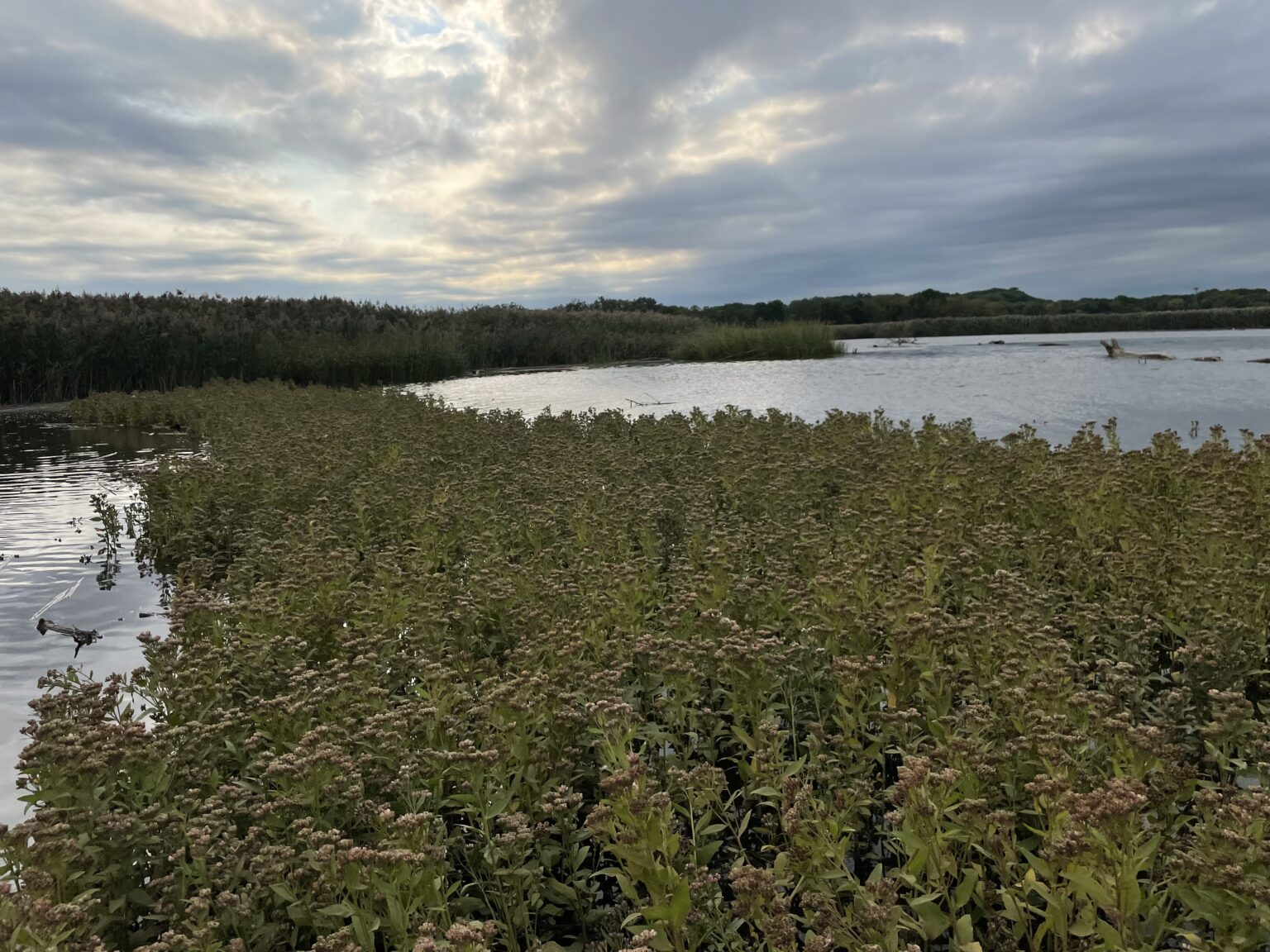
Through collaboration with our project partners and following input provided from a virtual stakeholder meeting held in December 2020, Princeton Hydro developed a conceptual design for an eco-park that incorporates habitat enhancement and restoration, and protective measures to reduce impacts from flooding while maximizing public access and utility. Public access includes trails for walking and designated areas for fishing. The eco-park can also be used for additional recreation activities such as bird watching and kayaking.
Highlights of the conceptual design include the following features:
- Approximately two miles of trails with overlook areas, connection to fishing access, and a kayak launch.
- ~3,000 linear feet of living shoreline, located along portions of the Washington Canal and the South River, to provide protection from erosion, reduce the wake and wave action, and provide habitat for aquatic and terrestrial organisms.
- ~60 acres of enhanced upland forest to provide contiguous habitat areas for resident and migratory fauna.
- A tidal channel that will connect to the existing mud flat on the southeastern part of the site and provide tidal flushing to proposed low and high marsh habitats along its banks.
- A vegetated berm with a trail atop will extend the length of the site to help mitigate flood risk.
- Two nesting platforms for Osprey, a species listed as “Threatened” in NJ
- Designated nesting habitat for the Diamondback Terrapin, a species listed as “Special Concern” in NJ