Article by Angely Melendez, written as part of the Rutgers Spring Semester 2020 Environmental Communications course
November 1, 2020 is World Vegan Day. Want to celebrate? See below for a listing of the many vegan and vegetarian restaurants in the Lower Raritan Watershed to choose from!
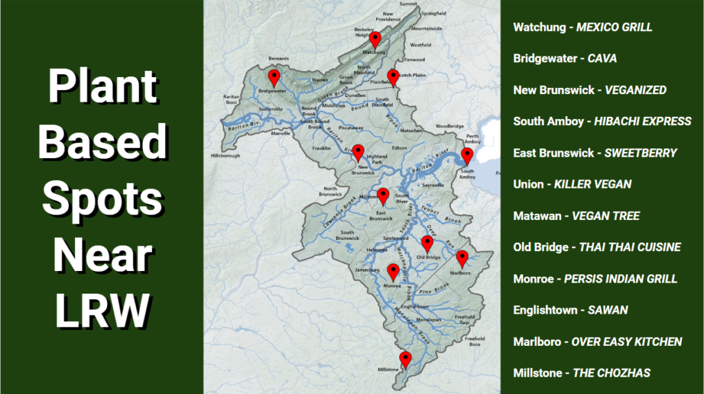
Plant Based Restaurants in the Lower Raritan Watershed
Ask someone just 20 years ago if they’d go vegetarian or vegan and they’d say no, you’re crazy. Meat has always been a staple within American cuisine and continues to be so, but even in the last 3 years there has been a 600% increase in Americans who consider themselves vegan. A staggering percentage, to say the least, but although those numbers are great, that’s still only 6% of American consumers in 2017 (“Veganism is at an All-Time High: Is it A Fleeting Fad or The New Norm?” 2018).
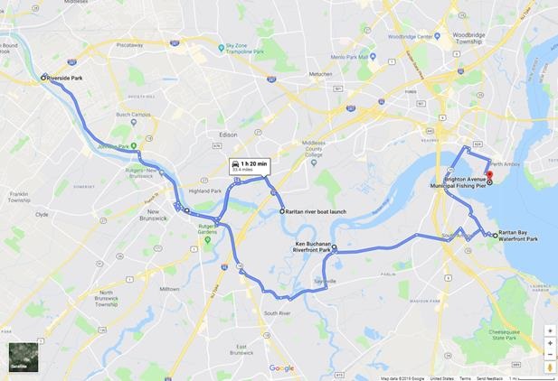
For the meat eaters out there that are still unsure of what the excitement is all about, I want to introduce World Vegan Day. This day visits us every November 1, and introduces the idea of the ever so popular diets: vegetarianism and veganism. Maybe the possibility of seeing what the hub-bub is all about intrigues you, and if that’s the case, then this is the day for you. See the map above for a route around the Lower Raritan River with stops all along it at plant based restaurants or others that feature plant based options.
So, what can these diets offer you? A slew of things, actually. One of the big factors to go plant-based is due to health. According to Harvard Medical School, a vegetarian diet offers some wonderful benefits and takes out some of the harmful negatives, “… As a result, [making them] likely to have lower total and LDL (bad) cholesterol, lower blood pressure, and lower body mass index (BMI), all of which are associated with longevity and a reduced risk for many chronic diseases.”
Besides personal gains, you’d also be doing the Earth (and our Lower Raritan Watershed) a huge solid. A big sign of inefficiency within agriculture lies within the raising of animals for their meat. About 70% of grain and cereals grown in the U.S. are fed to farm animals. Keeping that in mind, 16lbs of grain goes into producing 1lb of meat. And since demand for meat is so high, these farms continue to expand, knocking down natural ecosystems for the production of corn. Instead of using all those resources and high amounts of energy to produce that little amount of consumable meat, it could instead be used for humans.
So, come out to the Lower Raritan River during World Vegan Day, check out what local vegan and vegetarian restaurants have on offer, and learn why the grass is greener on the other side!
Effective communication about the environment is critical to raising awareness and influencing the public’s response and concern about the environment. The course Environmental Communication (11:374:325), taught by Dr. Mary Nucci of the Department of Human Ecology at Rutgers University, focuses on improving student’s writing and speaking skills while introducing students to using communication as a tool for environmental change. Students not only spend time in class being exposed to content about environmental communication, but also meet with communicators from a range of local environmental organizations to understand the issues they face in communicating about the environment. In 2019 and 2020, the course applied their knowledge to creating blogs for their “client,” the Lower Raritan Watershed Partnership (LRWP). Under the guidance of LRWP Founder, Dr. Heather Fenyk, students in the course researched topics about water quality and recreation along the Raritan. Throughout 2020 the LRWP will share student work on our website.
Article and photos (except as noted) by LRWP Board President Heather Fenyk
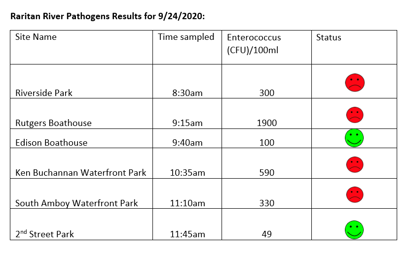
The LRWP and Rutgers Cooperative Extension of Middlesex County monitor for Fecal Coliform and Enterococcus at six non-swimming public beach access sites along the Lower Raritan during the warmer summer months. Fecal Coliform and Enterococcus are indicators of disease-causing bacteria in our waterways.
The EPA recommends that a single Enterococcus sample be less than 110 Colony Forming Units (CFU)/100mL for primary contact. Enterococci levels are used as indicators of the possible presence of disease-causing bacteria in recreational waters. Such pathogens may pose health risks to people fishing and swimming in a water body. Sources of bacteria include Combined Sewer Overflows (CSOs), improperly functioning wastewater treatment plants, stormwater runoff, leaking septic systems, animal carcasses, and runoff from manure storage areas. Enterococci levels are often high after heavy or consistent rainfall.
Below are our pathogens results for September 24, 2020. We are quite surprised by how bad these results are, given that we haven’t had rain for over a week.
Please note: results are preliminary and pending quality control.
Field Notes for 9.24.2020
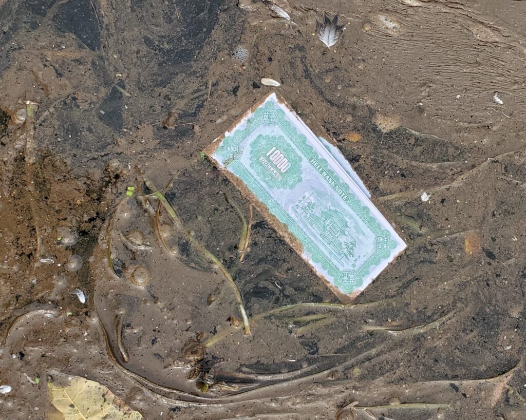
Hell Money
“Hell Bank Note” found in the water at Boyd Park
We aren’t quite sure what to make of this $10,000 “Hell Bank Note” found floating on the Raritan at Boyd Park. However, we DO know a great way to spend a Saturday and help the earth at the same time! Help us get trash like this out of the water during our Saturday September 26 socially-distanced clean-up of Seeley’s Run in Franklin Township! Due to COVID we are asking that folx register in advance.
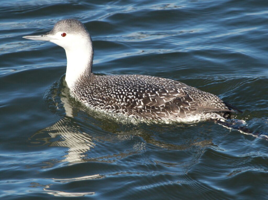
Birding!
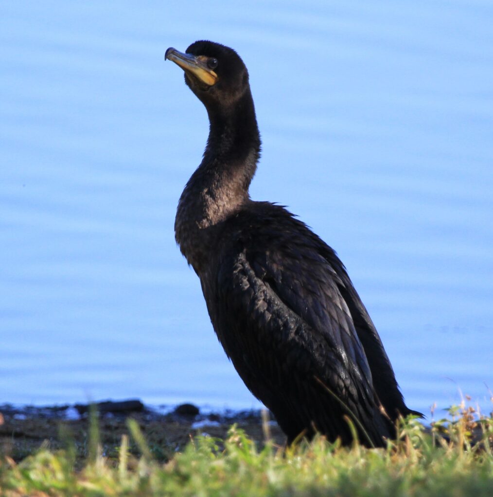
It is always a treat to go out sampling with a birder. LRWP volunteer Roger Dreyling knows his birds, and has a great eye for capturing them on film. We identified several types of gulls yesterday, saw osprey, mallards, cormorants, and caught up with a loon in South Amboy! It was fun to hear its haunting cry.
Common Loon – Photo: Roger DreylingDouble Crested Cormorant – Photo: Roger Dreyling
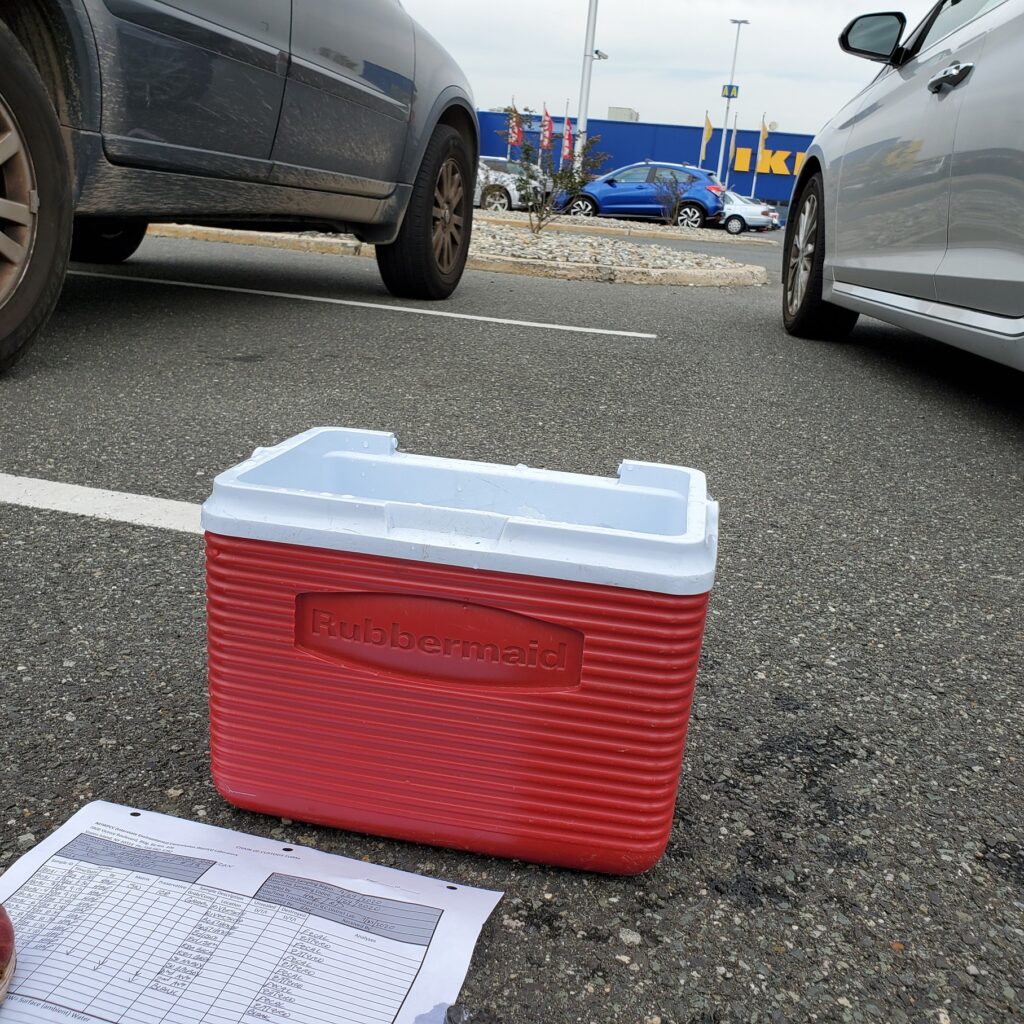
Pathogens Samples transfer
No doubt stranger items have been exchanged in the IKEA parking lot in Elizabeth, NJ. Still, passersby were curious as we scooped ice and sample bottles from one cooler to another not far from a sea of pressed plywood and Swedish meatballs. Many thanks to IEC’s Jessica Bonamusa for saving us a trip to her lab Brooklyn.
Water quality samples transfer to our IEC lab liaison.
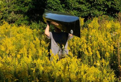
Self portrait of a paddler navigating a sea of goldenrod during the late September color blast. Much care was taken to not get yellow on the black canoe.
The rise of Venus in the early morning eastern sky is the celestial harbinger of a pre-autumnal dawn. As if a conductor raising her baton to stir the first musical strands of an orchestral performance, Venus instead, transforms sound into symphony of color.
As the dark sky lightens, a fluorescent orange orb slowly struggles skyward appearing to have escaped from the earth’s fiery core.
Once free of the earth’s grasp, the sun’s blaze orange begins to fade, dissolving in the atmosphere, melting into a wild spectrum of ever-changing pastel tints. Tints that concentrate in intensity as they fall to earth and color the late summer greenery with splashes of vibrant golds, yellow and purple variants.
The summer green mantle, which covered open fields for the past three months, was worn as a uniform of sort to make differentiation among grassland vegetation a difficult task.
With the imperceptible fading hot breath of late summer, vast expanses of vibrant yellow appear, as goldenrod reveals itself as an actor would at the end of a play. Depending on the species, goldenrod’s display of brilliant yellow may vary even further with soil conditions. NJ.GOV/pinelands lists six species of goldenrod, a feast for late season migrating pollinators.
Splashes of vibrant purple fresh from dawn’s display of pastels, stand in brilliant contrast to appear as delicate embroidery in the expansive blanket of golden yellow and green. Purple loosestrife, an invasive non-native plant, has established itself along the river and moist, overgrown pasturelands. Though loosestrife blooms from June to September, its presence in late-summer, is for some reason, more spectacular, perhaps its vibrant color is now more intense.
Artists use light and composition to direct attention to the main subject and then allow that focus to diffuse and absorb all the fine details so critical to support the entire work of art.
In nature we see the same strategy, which speaks more to revealing the innate human thought process than it does to suggest nature exhibiting intent. That thought aside, the beauty that surrounds us, is in itself, best felt emotionally rather than seasoned with logic and rationality.
The broad bold colored brush strokes painted across wide swatches of meadow and grassland are sufficient to capture attention and compel a search for the finer details.
Standing tall above the rest always garners a first glance among the crowd. Common mullein is another late season bloomer, pale green, tending to gray, with a long thick wooly stalk upon which a whorl of yellow flowers appears. The plant has many medicinal and practical uses. It seems the color yellow, dripped from the rising sun, is natures favorite, after green and blue. Ask which came first, insects evolving to adapt to yellow flowers or yellow flowers dominating because of insect choice.
Another example of fine art is Joe-Pye-Weed. Again, a tall plant which bears a large globe of tiny flowers tinted light pink to purple. The color taken directly from the evolving pastels displayed at dawn, even freezing the subtle movement seen as colors travel their spectral paths allowed by visible light. That long moment of change, as if time was captured in the still portrait of a Joe-Pye-Weed floret.
Ironweed is another common wildflower blooming in late summer. Small patches of this tall plant bear fluorescent dark purple flowers. The color stands in contrast to the earth tones of brown, tan, gray and green that dominate nature’s palette.
Cardinal flower, a native wildflower, blooms in moist areas in late August to September. Appropriately named, this plant bears several dark red cone shaped flowers that glow with such intensity and depth comparable to fresh drops of blood. The intense red coming directly from the glowing orb seen at dawn as it breaks free of the earth’s molten core.
Late summer and early fall are marked by changes in color. Colors previewed and mixed in the sky from effluent of the rising sun. As these colors emerge on the landscape, they mark the passage of time as effectively as a modern day calendar.
Instead of relying on standard numeric measures of time, we might say, the red is on the cardinal flower and the purple is on the iron weed and in doing so we color time.
Author Joe Mish has been running wild in New Jersey since childhood when he found ways to escape his mother’s watchful eyes. He continues to trek the swamps, rivers and thickets seeking to share, with the residents and visitors, all of the state’s natural beauty hidden within full view. To read more of his writing and view more of his gorgeous photographs visit Winter Bear Rising, his wordpress blog. Joe’s series “Nature on the Raritan, Hidden in Plain View” runs monthly as part of the LRWP “Voices of the Watershed” series. Writing and photos used with permission from the author. Contact jjmish57@msn.com. See more articles and photos at winterbearrising.wordpress.com.
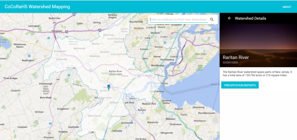
The Community Collaborative Rain, Hail, and Snow Network (CoCoRaHS), a national network of volunteer rain monitors, recently added some important new spatial and historical rainfall data mapping products by watershed at the HUC 10 level.
You can then click on the Watershed Maps, enter you address or zip code, and access the subwatersheds in the vicinity of your address. You can then click on your target watershed, and that watershed will come up with its area in acres and square miles, and a button for precipitation reports.
CoCoRaHs Watershed Map for Watershed Management Area 9
Click on the precipitation reports, and a “Configure Precipitation Report” box pops up. Click the drop down arrow, and you can choose between Daily Precipitation and Monthly Precipitation.
Daily Precipitation provides the Average Precipitation in inches for the pervious 24 hours for that subwatershed, along with the number of CoCoRaHS stations in the subwatershed. This data can be very useful for monitoring large rain events that can impact stream flows, flooding, and drought.
Choose Monthly Precipitation, and you can then choose monthly accumulated precipitation in inches for any month going back to 1998, and get the number of stations for that month.
Help track climate trends for the LRWP!
Can you help the Lower Raritan Watershed Partnership better understand climate trends? Let us know! We need a volunteer to extract historical rainfall data by month from CoCoRaHs data source and develop a monthly rainfall baseline so we can compare present and future monthly rainfall for climate trends analysis. We intend to eventually triangulate these data with our pathogens monitoring data.
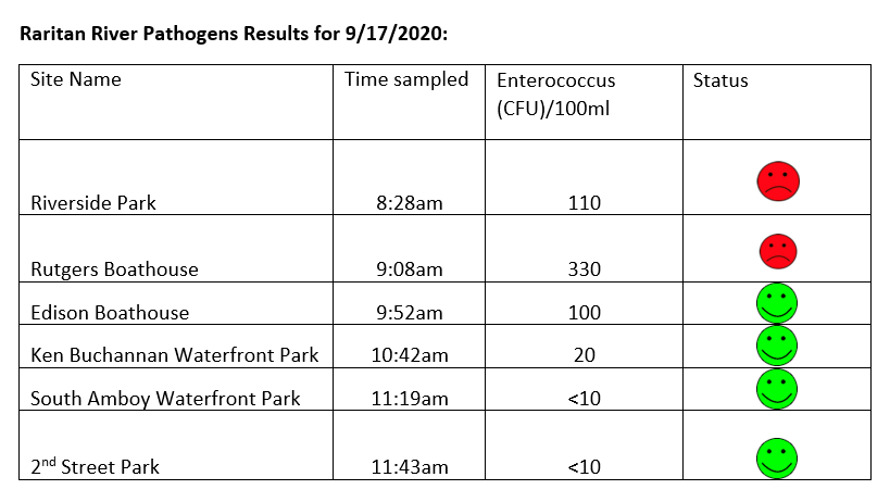
The LRWP and Rutgers Cooperative Extension of Middlesex County monitor for Fecal Coliform and Enterococcus at six non-swimming public beach access sites along the Lower Raritan during the warmer summer months. Fecal Coliform and Enterococcus are indicators of disease-causing bacteria in our waterways.
The EPA recommends that a single Enterococcus sample be less than 110 Colony Forming Units (CFU)/100mL for primary contact. Enterococci levels are used as indicators of the possible presence of disease-causing bacteria in recreational waters. Such pathogens may pose health risks to people fishing and swimming in a water body. Sources of bacteria include Combined Sewer Overflows (CSOs), improperly functioning wastewater treatment plants, stormwater runoff, leaking septic systems, animal carcasses, and runoff from manure storage areas. Enterococci levels are often high after heavy or consistent rainfall.
Here are our pathogens results for September 17, 2020. Things are looking good for our Raritan, and with no rain predicted for the next few days our waters should be flowing pretty clean.
Please note: results are preliminary and pending quality control.
Pathogens Results for Raritan River Public Access Non-Swimming Beach Sites
Field Notes for 9.17.2020
Hazy yellow skies during the day told a story of west coast fires and kept the temps down. Yesterday was a beautiful day for monitoring. Waters at our Rutgers Boathouse were covered with thick oily scum, origin undetermined. A far number of dead bunker floating in the water at our Edison Boat launch site. And there is still a fair amount of red algae at the South Amboy site – the algae has spread some to Perth Amboy.
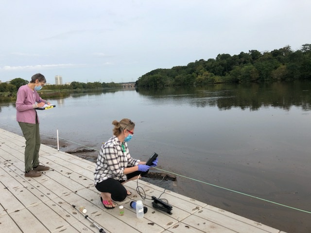
Susan and Heather capturing data and taking notes at Rutgers Boathouse site photo: Jessica Bonamusa
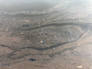
LOTS of scum, oil and muck at Rutgers Boathouse – photo: Jessica Bonamusa
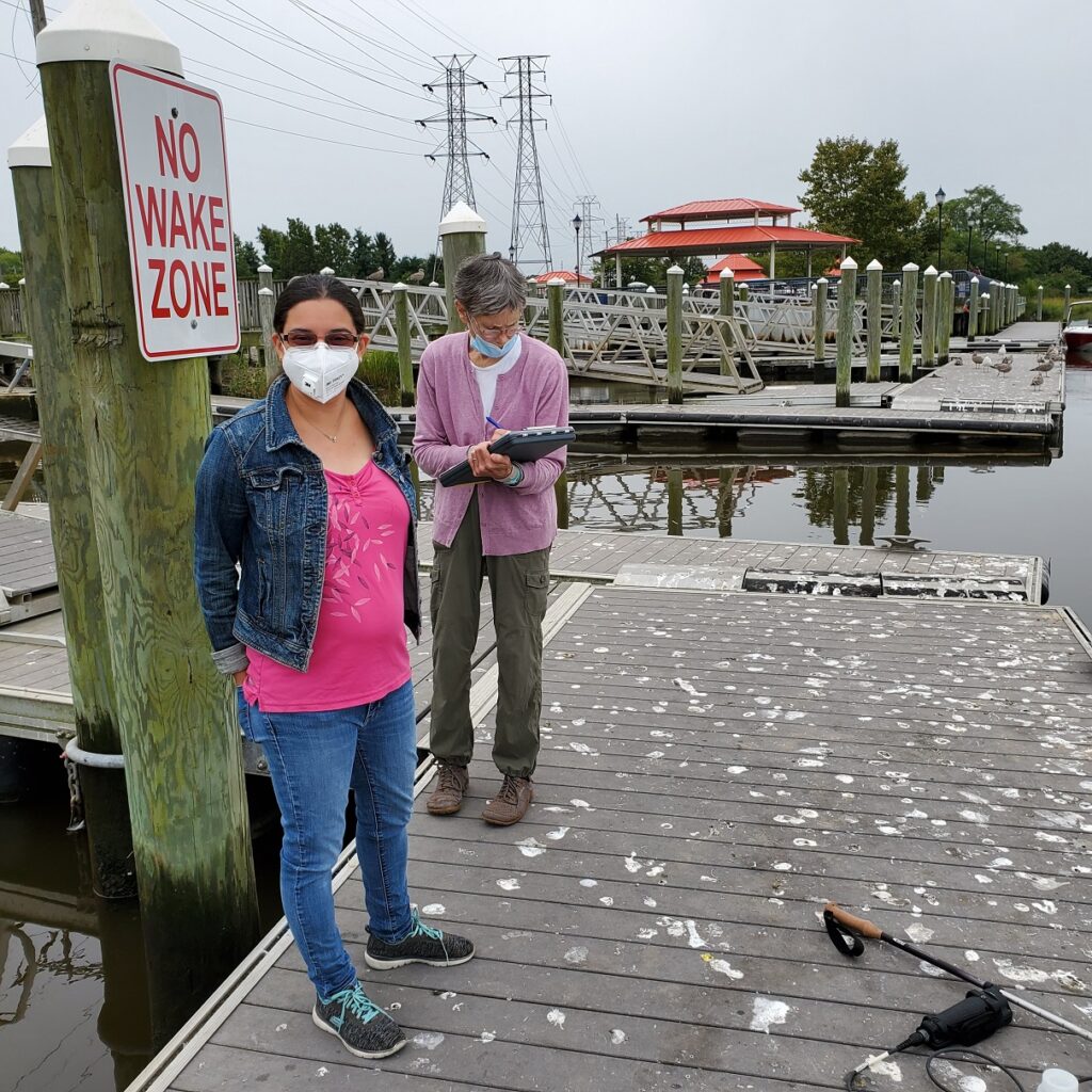
Jessica (IEC lab) and volunteer Susan making note of all the gull poop at the Ken Buchanan site in SayrevilleWe received a kayak loaner from our Raritan Riverkeeper friends to help us in our source track down and scouting. Thank you Bill Schultz and Lorraine!
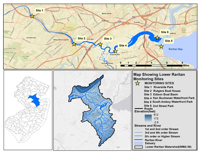
Summer 2020 Raritan Monitoring Sites
The New Jersey state Department of Environmental Protection and Middlesex County Health Departments typically monitor at sanctioned public swimming beach sites. They do not monitor the water quality for pathogens at public access non-swimming beach sites along the Raritan, despite regular use of these areas for primary contact (fishing and swimming) by members of our urban communities.
The LRWP works with in partnership with the Interstate Environmental Commission for lab analysis of our samples. We have a Quality Assurance Protocol Plan (QAPP) approved by the federal Environmental Protection Agency. We work to report our results as soon as lab analysis is completed.
Photos and article by LRWP Board President Heather Fenyk
The LRWP and Rutgers Cooperative Extension of Middlesex County monitor for Fecal Coliform and Enterococcus at six non-swimming public beach access sites along the Lower Raritan during the warmer summer months. Fecal Coliform and Enterococcus are indicators of disease-causing bacteria in our waterways.
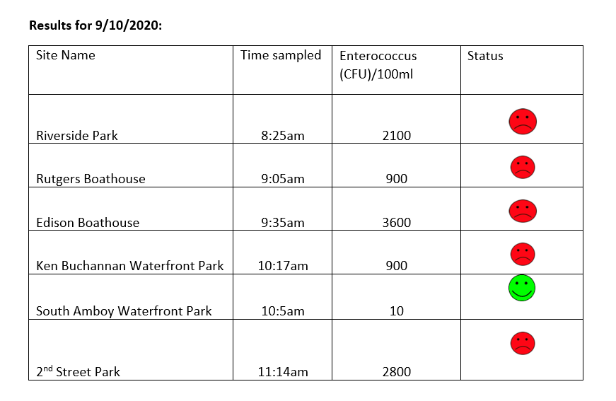
The EPA recommends that a single Enterococcus sample be less than 110 Colony Forming Units (CFU)/100mL for primary contact. Enterococci levels are used as indicators of the possible presence of disease-causing bacteria in recreational waters. Such pathogens may pose health risks to people fishing and swimming in a water body. Sources of bacteria include Combined Sewer Overflows (CSOs), improperly functioning wastewater treatment plants, stormwater runoff, leaking septic systems, animal carcasses, and runoff from manure storage areas. Enterococci levels are often high after heavy or consistent rainfall.
Here are our pathogens results for September 10, 2020. Please note that we received over an inch of rain in our Lower Raritan monitoring areas the evening after monitoring. As such we expect pathogens levels to be much higher than what was sampled in the morning.
Please note: results are preliminary and pending quality control.
Pathogens Results for Raritan River Public Access Non-Swimming Beach Sites
Field Notes for 9.10.2020
Lots of rain while monitoring our first three sites on September 10, 2020 made for a soggy day. The water at all sites was dark brown and thick with sediment from upstream. Our rain gauge showed 1.52 inches when we checked it the morning after monitoring. Most of that rainfall occurred on September 10 between 7-10 pm. Please take extra care when in any waterway after rainfall, especially heavy rains that send so much sediment and waste into our local streams and River.
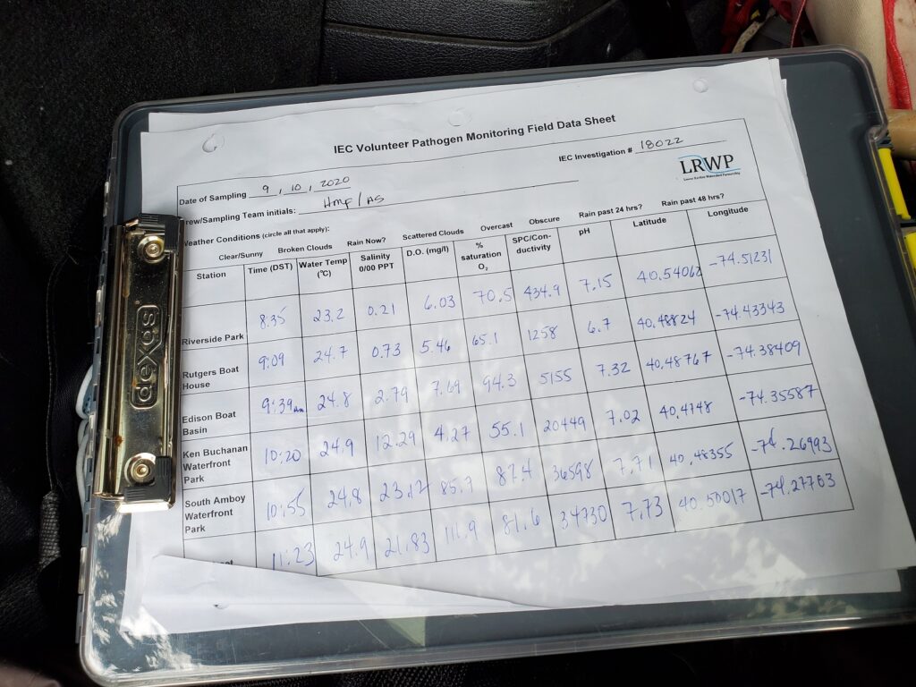
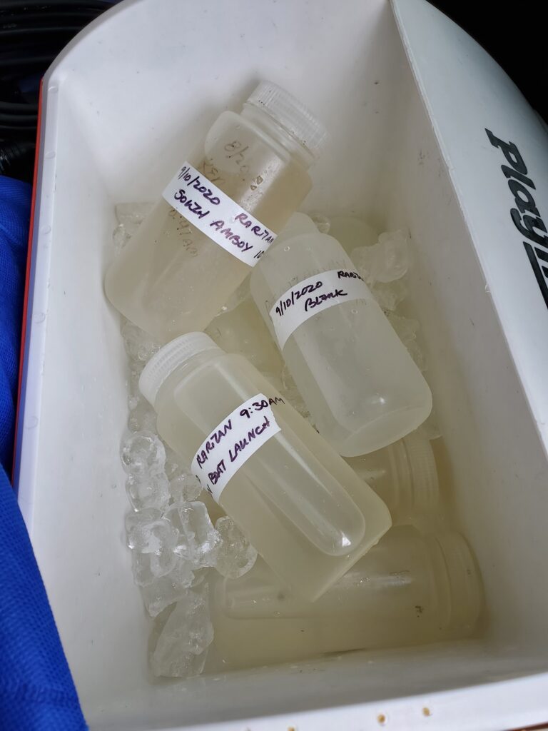
In addition to capturing water quality samples we collect data on salinity, temperature, dissolved oxygen, pH and other parametersSample bottles for genetic source trackdown, analysis conducted by Rutgers Fahrenfeld Lab
Genetic analysis will help us pinpoint the source of fecal loads in our waterways
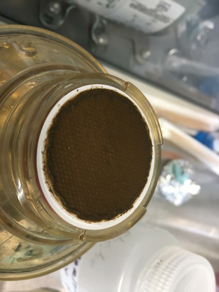
Filtering sample from South Amboy 9.10.2020 – Surf at the South Amboy site was particularly rough yesterday, with lots of red algae in the water. Photo – Michele Bakacs
Summer 2020 Raritan Monitoring Sites
The New Jersey state Department of Environmental Protection and Middlesex County Health Departments typically monitor at sanctioned public swimming beach sites. They do not monitor the water quality for pathogens at public access non-swimming beach sites along the Raritan, despite regular use of these areas for primary contact (fishing and swimming) by members of our urban communities.
The LRWP works with in partnership with the Interstate Environmental Commission for lab analysis of our samples. We have a Quality Assurance Protocol Plan (QAPP) approved by the federal Environmental Protection Agency. We work to report our results as soon as lab analysis is completed.
You can find more information on our monitoring sites here, and an overview of our pathogens monitoring program here.
Running for approximately 15 weeks through Summer 2020, the Lower Raritan Watershed Partnership and Rutgers Cooperative Extension of Middlesex County (RCE) will gather data and other information on water quality for public access sites along the tidal portions of the Raritan River at locations considered non-bathing beaches. This project is supported through grants from the Interstate Environmental Commission (IEC).
Summer 2019 Pathogens/Bacteria Monitoring Sites
LRWP and RCE will monitor non-bathing beach sites with active kayak/canoe launches and/or fishing and other primary contact activities that, as non-bathing beach sites, are not regularly monitored by the New Jersey Department of Environmental Protection (NJDEP) or the New Jersey Department of Health and Human Services and lack sufficient water quality data.
In addition to yielding important data about the health and safety of our waterways, the Project will also allow for development of civic science and expanded volunteer environmental monitoring programming within the Lower Raritan Watershed and Middlesex County, NJ. We are working with an approved Quality Assurance Project Plan (QAPP), provided by the IEC, which will allow for data generated from this project to inform water quality policy and regulatory decisions at all levels of government within the project area, and to educate the public about the safety of recreating on the River.
Real-time reporting of enteroccocus data will be posted every Friday on the LRWP facebook page and website, and through the New York City Water Trail Association’s citizen’s water quality testing program. Users will be able to easily interpret the data as being above or below the recommended water quality standards for primary contact recreation.
Enterococci levels are used as indicators of the possible presence of disease-causing bacteria in recreational waters. Such pathogens may pose health risks to people fishing and swimming in a water body. Sources of bacteria include Combined Sewer Overflows (CSOs), improperly functioning wastewater treatment plants, stormwater runoff, leaking septic systems, animal carcasses, and runoff from manure storage areas. Enterococci results are reported in Colony Forming Units or CFUs. Suitable levels should not exceed 104 cfu/100mL.
The following are details on our monitoring sites. We will share more information about each location throughout the monitoring period. For more information about the program please contact: info@lowerraritanwatershed.org
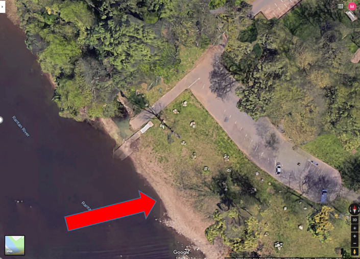
LR1
Riverside Park, 430 River Rd, Piscataway
40.54067
-74.51219
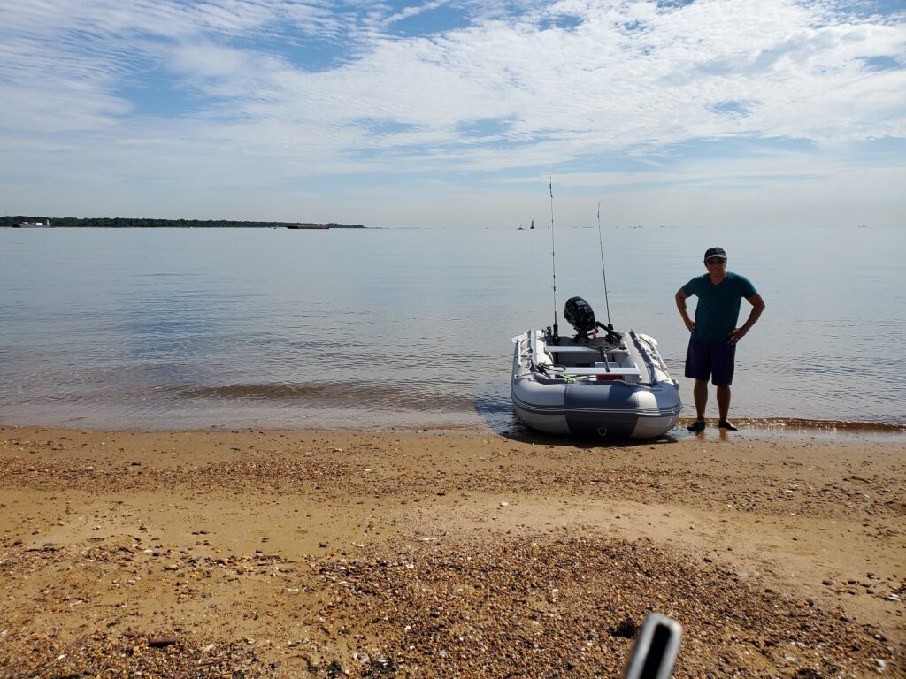
Wading site. Waders must be worn. Red arrow indicates the sampling location as this is where fishing has been observed. Access the river to the left of the boat ramp (when facing the river). Do not take the sample from the boat ramp as it is too muddy and slippery.
Bathrooms are available at this site from 10am to 2pm
LR2
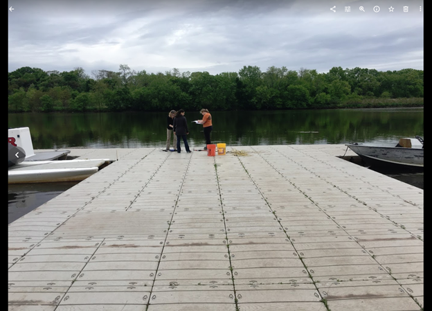
Rutgers Boathouse, 5 Memorial Pkwy, New Brunswick
40.48826
-74.43384
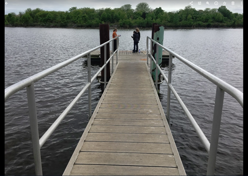
Sampling location is in the middle of the Rutgers boathouse dock as indicated in picture. Bathrooms may be available at the boathouse if they are open and at Boyd Park just west of the boathouse.
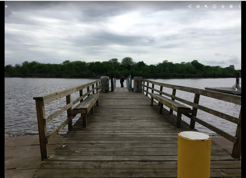
Sampling
location is at the end of the dock. No bathrooms are available at this site.
LR4
Ken Buchanan Riverfront Park River Road, Sayreville, NJ 08872
40.47483
-74.35586
LR5
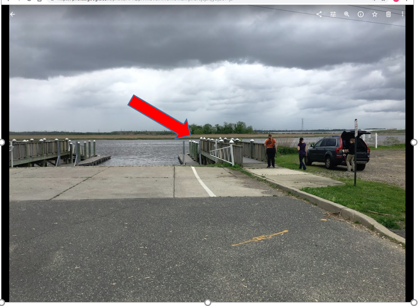
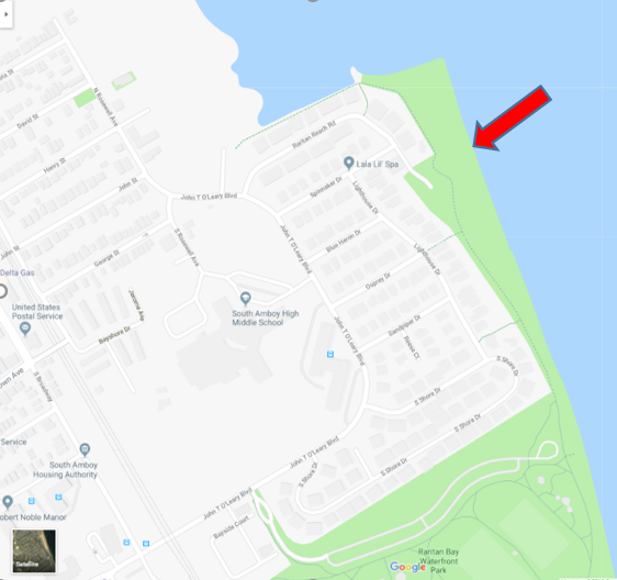
Raritan Bay Waterfront Park 201 John T O’Leary Blvd South Amboy, NJ 08879 *sample off Raritan Reach Road north of park
40.48334
-74.2698
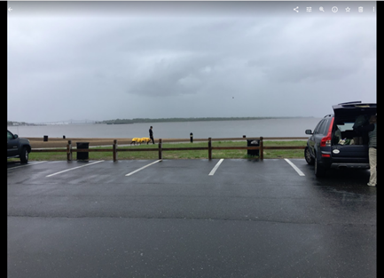
Wading site and waders must be worn. Access the sampling location off the parking lot at the end of Raritan Reach Rd. This is northwest of the park. The site is a beach. No bathrooms available.
LR6
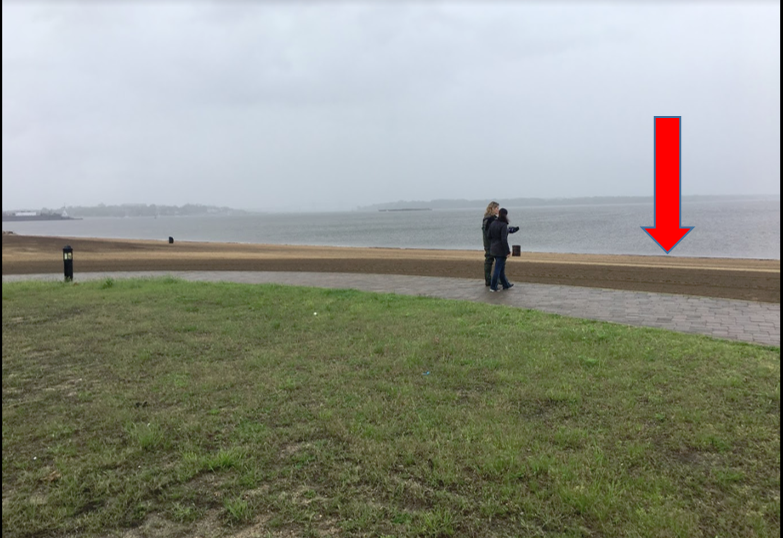
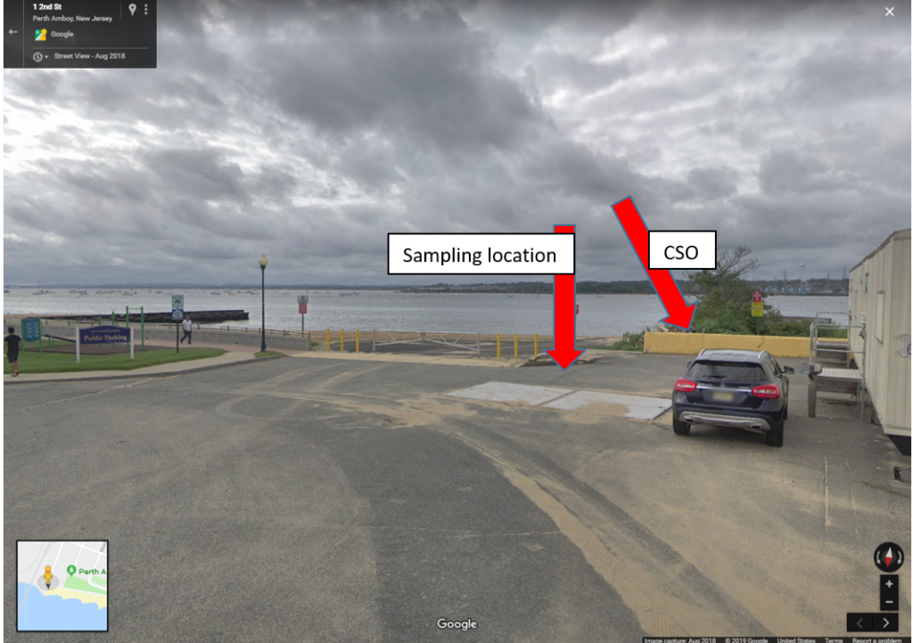
Perth Amboy Waterfront & Future 2nd Street Park 45-93 2nd St, Perth Amboy, NJ 08861
40.50007
-74.27719
This is a wading site and waders must be worn. Sampling location is at the beach next to the combined sewer outfall pipe. No bathrooms are available.
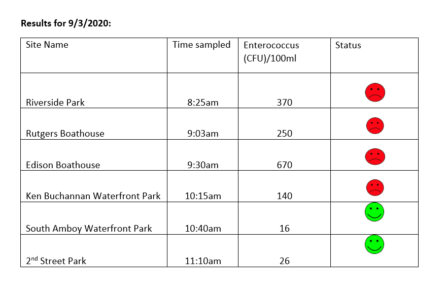
The LRWP and Rutgers Cooperative Extension of Middlesex County monitor for Fecal Coliform and Enterococcus at six non-swimming public beach access sites along the Lower Raritan during the warmer summer months. Fecal Coliform and Enterococcus are indicators of disease-causing bacteria in our waterways.
The EPA recommends that a single Enterococcus sample be less than 110 Colony Forming Units (CFU)/100mL for primary contact. Enterococci levels are used as indicators of the possible presence of disease-causing bacteria in recreational waters. Such pathogens may pose health risks to people fishing and swimming in a water body. Sources of bacteria include Combined Sewer Overflows (CSOs), improperly functioning wastewater treatment plants, stormwater runoff, leaking septic systems, animal carcasses, and runoff from manure storage areas. Enterococci levels are often high after heavy or consistent rainfall.
Here are our pathogens results for September 3, 2020. Please note that we received over an inch of rain in our Lower Raritan monitoring areas the evening after monitoring, we expect pathogens levels to be higher than what was sampled in the morning.
Please note that these results for August 20, 2020 are preliminary and awaiting Quality Control.
Field Notes
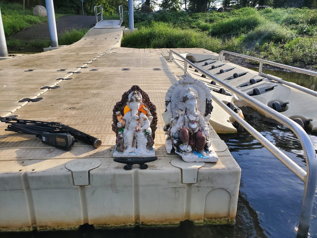
Another gorgeous day for pathogens monitoring! We found a few Ganesh in Piscataway – for those who celebrate Ganesh Chaturthi, we encourage you to remember the environmental message of Ganesh and please take your idols with you! Another week with lots of bunker in Edison and South Amboy and we heard folks were bringing in striper.
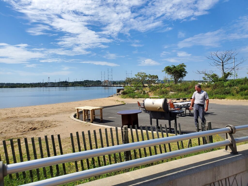
Boat Launch at Piscataway, NJ – Ganesh sculptures are remnants from the Ganesh Chaturthi festival. These should not be left in our waterways!Fishing for striper in South AmboyPerth Amboy DPW preparing for a BBQ at the 2nd Avenue Beach, with CSO in view
Summer 2020 Raritan Monitoring Sites
The New Jersey state Department of Environmental Protection and Middlesex County Health Departments typically monitor at sanctioned public swimming beach sites. They do not monitor the water quality for pathogens at public access non-swimming beach sites along the Raritan, despite regular use of these areas for primary contact (fishing and swimming) by members of our urban communities.
The LRWP works with in partnership with the Interstate Environmental Commission for lab analysis of our samples. We have a Quality Assurance Protocol Plan (QAPP) approved by the federal Environmental Protection Agency. We work to report our results as soon as lab analysis is completed.
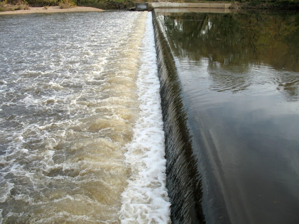
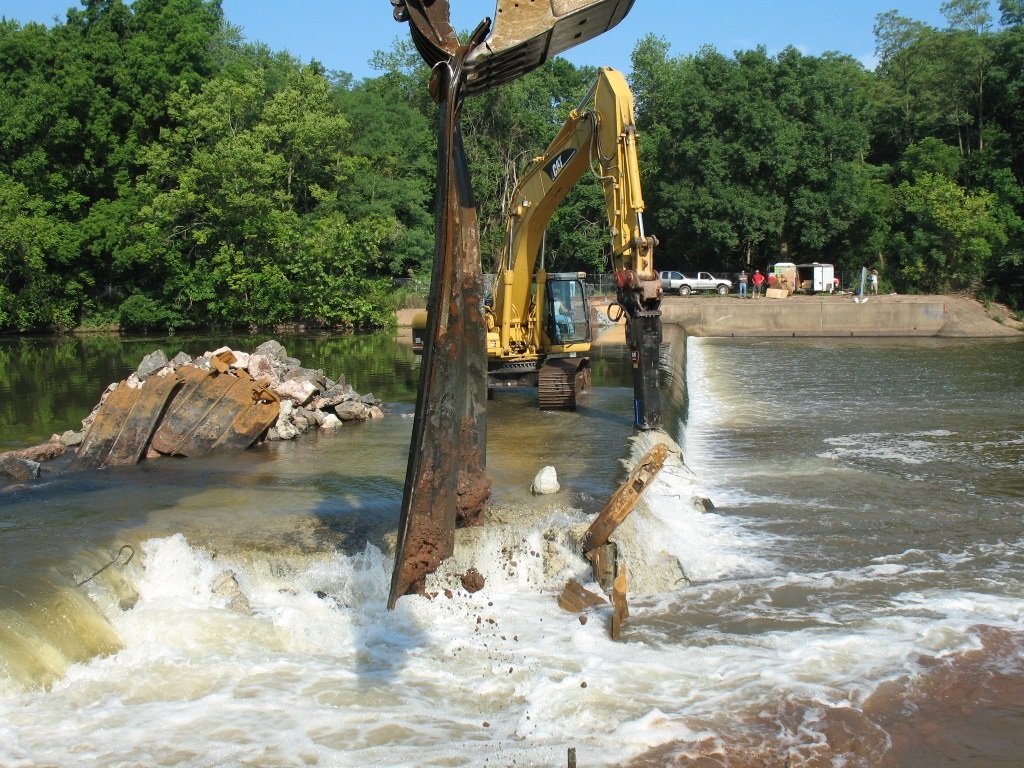
Robert Street Dam turbulent flow. Photo credit: John W. Jengo
The Robert Street Dam, located at Raritan RM 27.9, was near the eastern end of Duke Island Park in Bridgewater and Hillsborough Townships, Somerset County, New Jersey. The original dam at this location was constructed circa 1915 (referred to historically as the Dead River Dam or the Bradley Gardens Dam), but no written documentation has been found regarding the purpose of this structure and the entity that funded its construction remains unknown. My reconnaissance of the dam environs uncovered two concrete retaining walls on the south bank just upstream of the dam along the shoreline of Duke Farms. These features appear to have been the anchorage for a debris deflection boom, which may suggest that the so-called Dead River (a narrow U-shaped channel south of the Raritan River) may have been an irrigation canal that watered former agricultural fields on the Duke Farms property. An engineering report from 1963 revealed that about 100 feet of the Dead River Dam had overturned, settled, or had seriously deteriorated by the early 1960s, most likely due to water infiltration and scouring of the underlying foundation.
A substantial reconstruction of the dam was implemented in 1964 for the stated purpose of recreational boating, presumably to create an impoundment adjacent to the newly opened Duke Island Park upriver of this location. During the reconstruction, the remnants of the original dam were encased between parallel, horizontal waler beam-supported steel sheet piles, spaced 17.5 feet apart, which were driven into bedrock. Upon completion, the reconstructed dam was approximately 7.5 feet high, 255 feet long and had a width of 23 feet, which included a 17.5-foot-wide rock backfilled section between the sheet piles that entombed the original dam. Unfortunately, the Robert Street Dam (along with the Headgates Dam located two miles upriver) became one of the most significant obstructions to migratory fish passage in the Raritan River watershed, and the dam became the site of drowning fatalities of recreational boaters that were swept over the dam, trapping them in the deadly hydraulic jump and reverse roller that occurred at the base of the dam spillway.
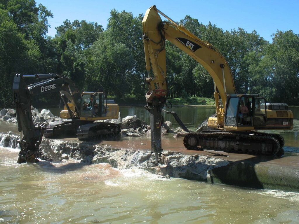
First Sheet Pile Removals at Robert Street Dam. Photo credit: John W. Jengo Robert Street Dam Spillway Demolition. Photo Credit: John W. Jengo
To remove the dam, numerous technical and permitting challenges had to be resolved over the 3-year planning and permitting period, including how to circumvent the inadequate Robert Street Bridge load capacity that precluded heavy equipment access to the dam site. To solve the access problem, careful daily monitoring of the river’s stage height over several years was conducted and the resultant data provided an indication of how low the river level needed to drop for a submerged sand shoal upstream of the dam to be less than 3 feet deep, enabling heavy equipment to be driven down the river from Duke Island Park to the dam. Technical obstacles that were overcome during the 5-week dam removal included managing the work around frequent upriver Round Valley Reservoir releases, the laborious extraction of over 300 individual sheet piles using two different hydraulic vibratory driver/extractors, and conveyance of over 700 tons of dam demolition concrete and 70 tons of steel sheet piles offsite for recycling.
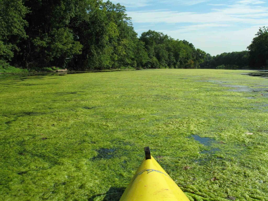
Filamentous Mat Algae on the Raritan River above the Robert Street Dam, credit: John W. Jengo
The removal of the Robert Street Dam, in conjunction with the removal of the Calco Dam and the Nevius Street Dam downriver, eliminated the physical barriers to anadromous fish passage along nine miles of the main stem of the Raritan River between RM 20.9 and RM 29.9 and the lower 1.5 miles of the Millstone River tributary. These removal projects restored access to historically significant spawning grounds for American shad (Alosa sapidissima), hickory shad (Alosa mediocris), blueback herring (Alosa aestivalis), and alewife (Alosa pseudoharengus) in New Jersey’s largest interior watershed and river system. My post-dam removal observations verify the elimination of the filamentous mat algae and stagnant water conditions behind the former Robert Street Dam and have shown that the natural river process of transporting sediment, woody debris, and nutrients has been restored. An outstanding example of this recovery would be the lifeless sand shoal that was used to access the dam from upstream, which was drowned for nearly 100 years in a de-oxygenated, algae-covered impoundment, that was transformed following the dam removal to a vibrant island habitat supporting plants, insects, and birdlife.
Robert Street Dam Removal Part One
Robert Street Dam Removal Part Two
John W. Jengo, PG, LSRP is a licensed Professional Geologist in several Northeastern and Southeastern states and a Licensed Site Remediation Professional in New Jersey. John works as a Principal Hydrogeologist in an environmental consulting firm in southeastern Pennsylvania. He has degrees in geology from Rutgers University (1980) and the University of Delaware (1982). Over the last 30 years, he has conducted the characterization and remediation of large, complex contaminated industrial sites throughout New Jersey, Pennsylvania, and Delaware. He played a key role in Natural Resource Damage (NRD) assessments that led to groundbreaking legal settlements to remove numerous low head dams on the Raritan and Millstone Rivers to restore historically significant migratory fish spawning runs. As technical project manager, he planned, permitted, and successfully managed the removal of the Calco Dam, the Robert Street Dam, and the Nevius Street Dam between 2008-2013, and the removal of the Weston Mill Dam on the Millstone River in 2017, along with leading the archaeological investigation of the former Weston Mill in the Borough of Manville and Franklin Township.