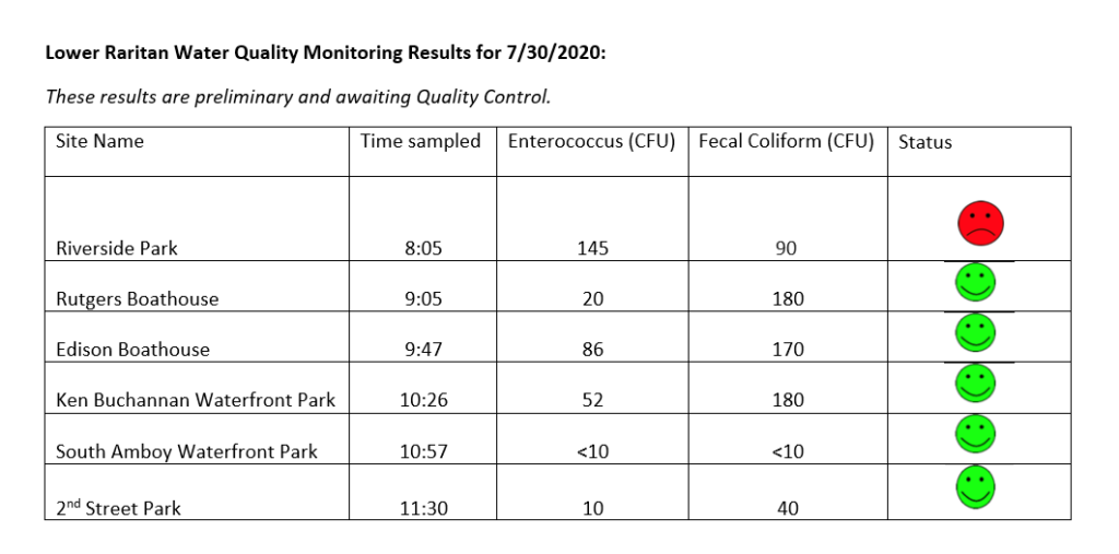
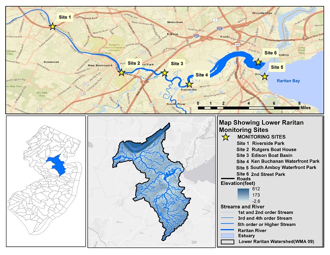
The LRWP and EARTH Center of Middlesex County monitors for Fecal Coliform and Enterococcus at six non-swimming public beach access sites along the Lower Raritan during the warmer summer months. Fecal Coliform and Enterococcus are indicators of disease-causing bacteria in our waterways.
The EPA recommends that a single Enterococcus sample be less than 110 Colony Forming Units (CFU)/100mL for primary contact. Enterococci levels are used as indicators of the possible presence of disease-causing bacteria in recreational waters. Such pathogens may pose health risks to people fishing and swimming in a water body. Sources of bacteria include Combined Sewer Overflows (CSOs), improperly functioning wastewater treatment plants, stormwater runoff, leaking septic systems, animal carcasses, and runoff from manure storage areas. Enterococci levels are often high after heavy or consistent rainfall.
Please note that these results for July 30, 2020 are preliminary and awaiting Quality Control:
The New Jersey state Department of Environmental Protection and Middlesex County Health Departments typically monitor at sanctioned public swimming beach sites. They do not monitor the water quality for pathogens at public access non-swimming beach sites along the Raritan, despite regular use of these areas for primary contact (fishing and swimming) by members of our urban communities.
The LRWP works with in partnership with the Interstate Environmental Commission for lab analysis of our samples. We have a Quality Assurance Protocol Plan (QAPP) approved by the federal Environmental Protection Agency. We work to report our results as soon as lab analysis is completed.
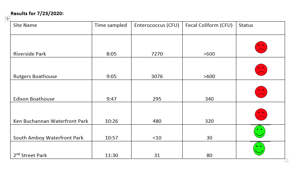
The LRWP monitors for Fecal Coliform and Enterococcus at six non-swimming public beach access sites along the Lower Raritan during the warmer summer months. Fecal Coliform and Enterococcus are indicators of disease-causing bacteria in our waterways.
The EPA recommends that a single Enterococcus sample be less than 110 Colony Forming Units (CFU)/100mL for primary contact. Enterococci levels are used as indicators of the possible presence of disease-causing bacteria in recreational waters. Such pathogens may pose health risks to people fishing and swimming in a water body. Sources of bacteria include Combined Sewer Overflows (CSOs), improperly functioning wastewater treatment plants, stormwater runoff, leaking septic systems, animal carcasses, and runoff from manure storage areas. Enterococci levels are often high after heavy or consistent rainfall.
Please note that these results for July 23, 2020 are preliminary and awaiting Quality Control:
The New Jersey state Department of Environmental Protection and Middlesex County Health Departments typically monitor at sanctioned public swimming beach sites. They do not monitor the water quality for pathogens at public access non-swimming beach sites along the Raritan, despite regular use of these areas for primary contact (fishing and swimming) by members of our urban communities.
The LRWP works with in partnership with the Interstate Environmental Commission for lab analysis of our samples. We have a Quality Assurance Protocol Plan (QAPP) approved by the federal Environmental Protection Agency. We work to report our results as soon as lab analysis is completed.
Field observations for July 23, 2020:
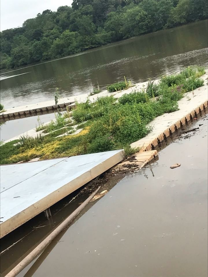
Water was mucky and running fast from Wednesday’s storms. There was 1.11 inches in the rain gauge Thursday morning before we left for monitoring. We got soaked through while we were in the field, with rains continuing through the day. There was especially hard rainfall early this morning (Friday July 24) with a total accumulation in the rain gauge today of 2.07.
This was our first time out monitoring since October 2019. Some of our sites are neglected, and all bathrooms are closed. The Rutgers Class of 1914 Boathouse launch, home to RU crew, is hard to distinguish from a floating wetland. Geese, gulls and ducks have the run of the Piscataway, Edison and Ken Buchanan sites.
Rutgers Class of 1914 Boathouse launch – 7.23.2020
The South Amboy and Perth Amboy sites were active with fisher folk. There are tons of menhaden in the water at South Amboy! We hear there are sharks going after them so please be careful in the water.
Many thanks to Jessica Bonamusa and our Interstate Environmental Commission friends for helping us out with lab analysis. And special thanks to Julie Blum for helping develop a new app for data entry!
Emily Koai, LRWP Raritan Scholar Intern Spring 2020
New Jersey’s habitat faces significant barriers due to an expanding urban landscape. Ecosystems of interdependent flora and fauna are interrupted by the hustle and bustle of high-volume traffic and concrete, man-made passages of culverts. This juxtaposition gives us pause to reflect on what can be done to help wildlife connect to their habitats across our built environment. We are prompted consider our urban landscape and promote connectivity between our natural spaces and to improve and enhance the relationship between our natural environment and our urban communities.
Originally scheduled for March 16th, the LRWP’s much anticipated habitat connectivity workshop was held virtually on May 4. Many thanks to our partners – Middlesex County Office of Planning, NJDEP, and NY/NJ Harbor Estuary – for persevering and helping us bring these tools and knowledge to participants via a virtual platform! A video of Mr. Zarate’s presentation is now on youtube.
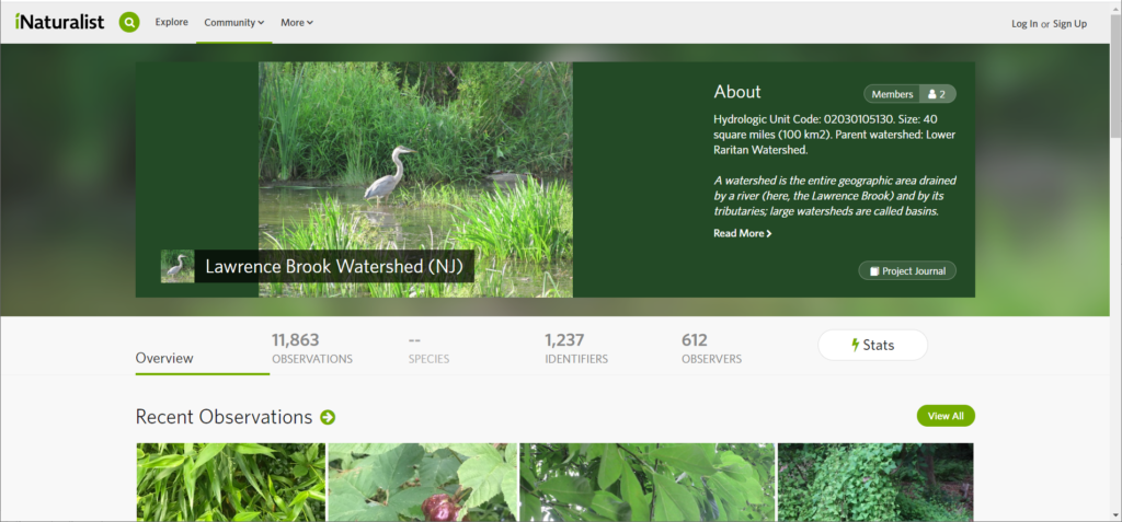
Working with tools shared during the workshop, our friend Herve Barrier created an inaturalist project for the Lawrence Brook subwatershed. Herve explains: “I copied the borders, street by street, using the CHANJ map, after selecting only the ‘watershed’ layer. I am working to make it more and more precise.” Feel free to add your own observations to the growing tally of almost 12,000 observations in the Lawrence Brook sub-watershed! Interested in starting an inaturalist page for another sub-watershed of our Lower Raritan? Let us know!
Webinar Recap
To kick things off, Isabelle Stinnette explained how she and her team from the NY/NJ Harbor Estuary Program set out to explore potential passages for our diadromous and potadromous fish friends through their Aquatic Connectivity Through Climate-Ready Infrastructure Project. What they found were tens of culverts and barriers in the Lower Raritan that obstruct the passability for aquatic wildlife. Blocked up by debris and soil, many of these sites have the potential to be opened up or mitigated into effective passages, a sentiment that excited volunteers. This project uses the North Atlantic Connectivity Collaborative protocols (www.naacc.org) in concert with a hydraulic model to make recommendations for connectivity restoration in New Jersey watersheds.
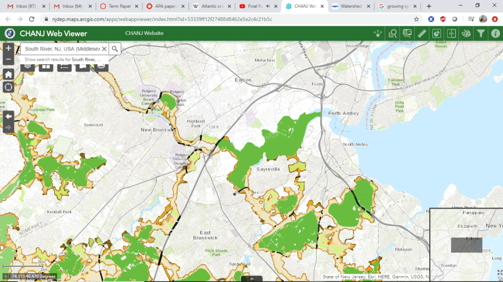
To help illustrate the potential for these obstructed passageways, Brian Zarate, along with Gretchen Fowles, the originator of CHANJ (Connecting Habitat Across New Jersey), helped bring habitat connectivity to our screens. Launched in 2019, CHANJ provides innovative tools that map out natural land cover in relation to our urban environments and further guidance “to help prioritize land protection, inform habitat restoration and management, and guide mitigation of road barrier effects on wildlife and their habitats”. Layer by layer, the mapping tool reveals the islands of greenery our wildlife seek refuge in and, connecting them, corridors or stepping stones, pit stops for our terrestrial friends. With ease of access to information about each core, recommendations, and even NAACC protocols utilized by Isabelle and her team, the tools of CHANJ bring us closer to our goal of habitat connectivity.
Partial view of Middlesex County. Cores (green), large areas of contiguous lands suitable for larger, more mobile terrestrial life. Stepping Stones (light green), smaller areas of contiguous land. Corridors (beige + gradient), ease of passability.
We are now presented with an opportunity to consider fish ladders, debris removal, and underpasses to help aid wildlife carry out their natural life cycles. The branch now extends to our municipal partners, counties, and DoTs to consider this opening to administer changes that will help build bridges across built environments for our wildlife
Indicative of urban sprawl, the visible islands for wildlife now have evolving needs for preservation. Whittled down to beige and green corridors and stepping stones on our screens, CHANJ and the work of the HEP gives us the means to see opportunities for connections between our natural and built environments. Wildlife have had to adapt to their altered environments as development slowly engulfed their living quarters. With green islands surrounded by the liveliness that is our urban environment, our role as stewards now extends to the advocation of habitat connectivity to help enhance our relationship between our natural environments and urban communities.
Whether on the statewide, local, or backyard scale, CHANJ can help us to visualize our place in New Jersey’s habitat connectivity puzzle and to take steps to preserve and restore important linkages for wildlife across the landscape.
Not sure where to begin? Don’t sweat, the CHANJ Mapping Tutorial will walk you through it! This step-by-step video shows you how to use our online interactive CHANJ Web Viewer (mapping tool), so you’ll be up to cruising speed in about 10 minutes.
Want to learn more about habitat connectivity in New Jersey? See PBS’s Eco Sense for Living’s “Wild Crossings” special feature highlighting local habitat connectivity work.