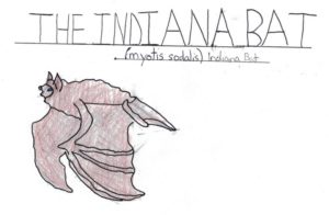
The Watershed Illustration Curriculum was developed to raise awareness about the endangered species of New Jersey, especially the flora and fauna of the Lower Raritan Watershed. Every species in the curriculum, from the Bald Eagle to the Closed Bottled Gentian, is in immediate danger due to human activities. These human activities are responsible for loss of species habitat due to habitat fragmentation and deforestation, over-exploitation of resources, disturbances, disease, introduction of invasive species, pollution and climate change. The survival of every species of wildlife is critical to preserving our state’s rich biodiversity and unique natural history.Unlike other natural threats, man-made threats are threats that we can prevent by changing our behavior.
These curriculum guides combine art and science to help students develop their creativity and artistic skills, while advancing their knowledge of the endangered species and plants that are in close proximity to them. By focusing on art, we also try to make the connection to the environment a personal experience. To save wildlife requires positive action. It requires changes in lifestyle and way of thinking.
As humans, we have the ability to understand the consequences of our actions, both present and past. We are capable of learning more about the effects our actions have on the world around us and how changes in those actions could help to alter future events. By examining how human activities have adversely impacted life on earth, we can take steps to reverse past damages and prevent future damage.
Thank you for learning about the special wildlife in the Lower Raritan, and how you can help protect them!
In our efforts to diagnose stream, river and watershed health, we regularly assess conditions in only a small portion of our waters. Even in those, we typically measure only a few things once a summer, or once every few years. What’s more, we may realize later we measured the wrong things, or used the wrong tool, at the wrong time, perhaps in the wrong way. We know that the quantity and quality of the data we obtain today is not adequate to diagnose our watersheds’ health and to prescribe the right actions to protect or restore them. So why then do we continue to monitor?
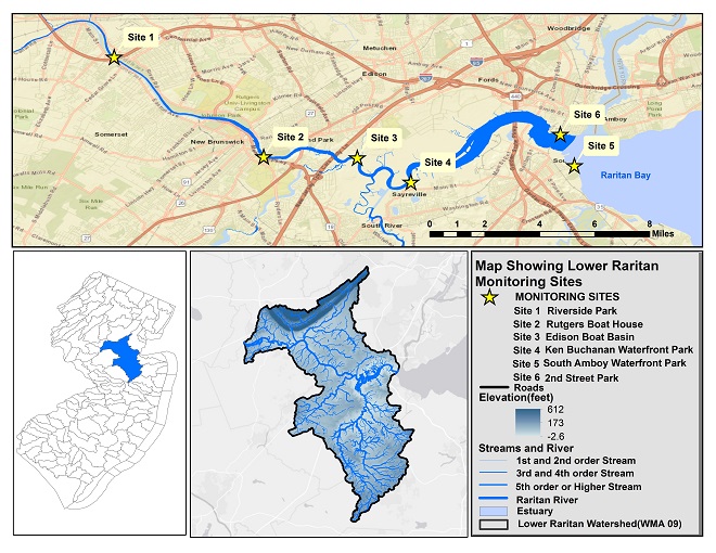
Sites of freshwater monitoring conducted by Lower Raritan Watershed Partnership “civic science” volunteers
Why monitor?
Critics of monitoring programs correctly point out that getting obsessed with gathering more data can blind us to clear lessons already learned and divert our attention and resources from actions clearly needed. It may be the case that not every stream needs on-going monitoring. But good monitoring activities should be underway in most of our streams and sub-watersheds.
The LRWP sees five major categories of benefits of long-term watershed-based monitoring programs:
1. Enhancing environmental education. People learn best from hands-on experience. One good day in the field studying a river provides more longlasting environmental lessons than ten lectures endured, a hundred news stories read, or a thousand one-line environmental slogans overheard. Monitoring inevitably promotes greater understanding and awareness in a community. When understanding and awareness grow, greater protection and stewardship almost always follow.
2. Clearly defining problems. Monitoring may help confirm fears about watershed problems and trends. It may also help dispel them. By helping us get a firm grip on the nature and magnitude of watershed problems, monitoring helps us focus our efforts and resources on the most important problems to address. When monitoring confirms that a water body is clean and healthy, it helps us define the desirable conditions we need to maintain over time.
3. Pinpointing sources of problems. Understanding what a watershed’s biggest problems are is only half the battle. The other is determining the real sources of those problems. A single problem may be the result of multiple sources, and multiple problems may stem from a single source. Thoughtful, comprehensive, adaptive, long-term monitoring helps us be sure we are addressing all the major sources of problems, not just some of their collective symptoms.
4. Setting standards and goals. Voluntary and regulatory watershed programs both work best when they are based on solid standards and clear goals. The best standards and goals grow from a well grounded understanding of historic and current conditions and trends. Without this type of understanding, standards and goals may be set inappropriately. If they are too low, protection and restoration efforts will not be aggressive enough, and opportunities may be delayed or missed. If they are too high, expectations may be unrealistic and the enthusiasm of involved parties may wane over time. Monitoring helps us set the bar at the right level for each watershed.
5. Providing benchmarks for measuring progress. Restoration and protection efforts cost money and take time—usually, years. Involved parties need clear evidence that their efforts are making a difference if they are to continue to justify their time, effort and expense. Consequently, monitoring before, during and after intensive protection and restoration efforts helps us explain the importance of current efforts and make the case for new ones.
Next steps
Of course the state and federal entities that have mandates to bring about fishable, swimmable waters can and should do more. However, government has not proven its capacity to do everything necessary for healthy waters. In addition to building and securing support for our monitoring programs we need to coordinate governmental and non-governmental monitoring efforts. We need to target those efforts toward better fundamental understanding of our watersheds and their problems. And we need to involve legions of interested and concerned citizens in the ongoing business of assessing watershed conditions and trends.
Brackish water sites monitored for presence of pathogens/bacteria by the Lower Raritan Watershed Partnership
Article and photos by William Baumle, written as part of the Rutgers Spring Semester 2019 Environmental Communications course
Waterways possess an essential ecological value, providing a wide range of ecosystem services. Ecosystem services are benefits the natural world provides to humans. For waterways, these benefits are the result of a combination of a waterway’s hydrology, vegetation, fauna, and micro-organisms. Together, these natural structures and organisms provide beneficial outcomes for people, animals, and other ecosystems.
Unfortunately, human development has often resulted in waterways being diverted underground to make way for the construction of roads and buildings. Do you know a “River Road” or “Water Street” near you, but not near water? It may be that sometime in the past, there was a waterway there that was diverted underground to make way for people.
Hidden waters of Metuchen
Did you know? The name “Metuchen” first appeared in 1688/1689, and its name was derived from the name of a Native American chief, known as Matouchin or Matochshegan.
The Borough of Metuchen, located within Middlesex County and wholly surrounded by Edison Township, has quite an interesting history of hidden waterways. While burying and/or paving over historic streams and tributaries is not unique, the vast number of waterways which have been covered for the sole purpose of development within the Borough of Metuchen is notable.
Metuchen, 1876 Source: Rutgers MapMaker
Due to development, few waterways or bodies of water exist within the Borough today. By comparison, a map from 1876 indicates the presence of multiple waterways around modern-day Amboy Avenue and Main Street, with one exiting to a pond located on Lake Avenue. The map also shows that Metuchen had several notable ponds and lakes, nearly all of which have been filled in or covered. There were a number of ponds along what we now know as High Street but all those ponds have been buried and now lie beneath rows of houses. Only Tommy’s Pond remains.
Tommy’s Pond in Metuchen, 1950sSkating on Tommy’s pond in Metuchen
Today, a number of unnamed streams run through the Borough of Metuchen, which, in addition to the recently manmade waterway which accompanies the Middlesex Greenway, drain into the Raritan Watershed. Interestingly, Metuchen is distinctive among New Jersey communities in that it is comprised of not even three-square miles and yet drains into three separate sub-watersheds. Three headwater tributaries which originate in the Borough, drain into Bound Brook. The southwestern areas of the town drain into the Mill Brook, located within Edison Township. The northeastern areas of the town drain into the South Branch of the Rahway Watershed.
Directly outside of Metuchen lies a 500-year flood zone, which simply means that in any given year, there is a 1/500 chance a significant flood will affect the area. While Metuchen does not have any significant sources of flooding, there are a few minor areas of the floodplain associated with the Dismal Swamp Preserve and a channelized portion of the Middlesex Greenway. Unsurprisingly, the areas indicated as being the greatest risk of flooding are located along historical streams and tributaries, which have been largely filled in. Notably, however, this area of the Borough has not historically regularly flooded – only in rare instances, such as the aftermath of Hurricane Irene (2011) and Hurricane Sandy (2012).
Spies, Stacey E. (2000) Images of America: Metuchen. Mount Pleasant, SC. Arcadia
Effective communication about the environment is critical to raising awareness and influencing the public’s response and concern about the environment. The course Environmental Communication (11:374:325), taught by Dr. Mary Nucci of the Department of Human Ecology at Rutgers University, focuses on improving student’s writing and speaking skills while introducing students to using communication as a tool for environmental change. Students not only spend time in class being exposed to content about environmental communication, but also meet with communicators from a range of local environmental organizations to understand the issues they face in communicating about the environment. In 2019, the course applied their knowledge to creating blogs for their “client,” the Lower Raritan Watershed Partnership (LRWP). Under the guidance of LRWP Founder, Dr. Heather Fenyk, students in the course researched topics about water quality and recreation along the Raritan. Throughout 2020 the LRWP will share student work on our website.
Just before COVID-19 upended our lives, a new committee was created in the New Jersey State Assembly to focus on issues related to water – including beach erosion, water integrity and security, dams and reservoirs, algae blooms, lead contamination, wastewater infrastructure, stormwater challenges, and the effects of climate change. We’re thrilled to have the chair of this committee join us on a virtual town hall next week.
On Wednesday April 29 from 6:30-7:30 pm, the Lower Raritan Watershed Partnership will join New Jersey League of Conservation Voters, New Jersey Conservation Foundation, Coalition for the Delaware River Watershed, and Association of New Jersey Environmental Commissions in hosting a statewide virtual townhall with the chair of that committee; Assemblyman Karabinchak.
Join us Wednesday, April 29 from 6:30–7:30 p.m. to hear from Assemblyman Robert Karabinchak on what he hopes to accomplish in his new committee.
This will be a great time to share your concerns, and ask questions of Assemblyman Karabinchak about how this new committee will work to protect our water and other natural resources.
We will also soon send invitations for a virtual flyover “tour”
of our Lower Raritan Watershed. This special event will include Q & A with photographer
Alison M. Jones, who will share images of the Raritan Basin taken during a
recent flight sponsored by LightHawk.
The Covid-19 crisis has a huge impact on humanity, on our institutions, on ourselves.
During this time, it is hard to stay engaged in the
environmental issues we care so deeply about.
Many of you have reached out in the past several weeks to encourage the LRWP to move forward with our planned “virtual” clean-ups for Earth Week.
At the request of local leaders, including Mayors and Councilmen from around the watershed, we have decided not to support these virtual events.
Since the closing of parks by Governor Murphy, Mayors from both sides of the political aisle have expressed their view that encouraging outdoor clean-ups of public spaces is at odds with Murphy’s Executive Order.
In addition, these leaders are concerned that policing closed public parks may present challenges for local law enforcement. They also wish to reduce the risk for their already high-risk DPW workers and avoid putting an additional burden on them with refuse from clean-ups.
Of course the LRWP is eager to get out to clean-up our beloved outdoor spaces, however we respect concerns of our local leadership and honor their request.