Artículo por Magdalena Mysliwiec, estudiante de posgrado de Rutgers y participante en el estudio
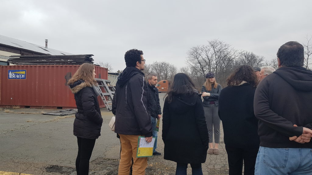
Frente a Pacers Field en South River (NJ) – área propensa a las inundaciones, junto a lugareños lo suficientemente amables como para darnos un recorrido por la ciudad; el equipo del Estudio de Planificación Ambiental de la Universidad Rutgers de Primavera 2020, compuesto por siete estudiantes de posgrado y en asociación con la organización sin fines de lucro Lower Raritan Watershed Partnership, tuvo la oportunidad de tener un primer acercamiento al agua que fluye por esta comunidad. Ver y escuchar las historias y preocupaciones de los guías turísticos locales sobre South River sirvió como introducción del equipo para aprender sobre la relación de la comunidad con sus sistemas de agua y como estos afectan al barrio, desde las personas que lo habitan y su salud hasta los edificios en los que se vive y trabaja. Una relación con la que todas las ciudades de Nueva Jersey están familiarizadas y de la que todas se benefician.
Estudiantes de Rutgers en el tour de South River (NJ), South River Green Team
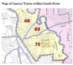
El equipo del estudio dedicó el semestre a estudiar South River, sus habitantes, sus viviendas y el agua, incluyendo el que se origina en otras partes de Nueva Jersey y que luego fluye hacia South River. Los participantes centraron su atención en el Censo 69 (reflejado en el mapa a continuación), la zona con la esperanza de vida más baja en el condado de Middlesex. La investigación del equipo también tuvo como objetivo preparar a la comunidad de South River para participar en un proyecto del Departamento de Protección Ambiental de Nueva Jersey (NJDEP). Este proyecto busca desarrollar una mayor resiliencia (o capacidad de recuperación) de la ciudad ante futuros eventos climáticos extremos como son las inundaciones.
Mapa de censos incluidos en South River
Como resultado de los problemas de esperanza de vida en el Censo 69, el equipo del estudio estableció el objetivo de lograr resultados de salud equitativos para todos los residentes de esta multicultural comunidad. El equipo identificó tres categorías de problemáticas que South River debe abordar: la planificación regional, el diseño y el desarrollo comunitario. Estas tres dimensiones se describen en el documento adjunto de una página y que está disponible en inglés y en español. Es importante destacar que las soluciones a dichas problemáticas requieren de asociaciones entre diferentes actores, incluso entre los propios residentes de South River. Por ejemplo, el gobierno y las agencias locales deben avanzar en los pasos necesarios para lograr involucrar a habitantes de todos los orígenes culturales en las decisiones orientadas a conseguir una ciudad resiliente. Esto significa ser creativo y llegar a la comunidad, por ejemplo, organizando eventos culturales donde los locales puedan compartir cómodamente sus opiniones sobre las decisiones de la ciudad o boletines informativos como este en inglés y español. En el informe final del equipo de estudio, disponible en el listado de recursos que se muestra a continuación, se pueden encontrar más propuestas y recomendaciones.
El equipo del estudio también grabó la “Water Story” de South River utilizando la herramienta Water Story de la organización sin ánimo de lucro Sustainable Jersey. Esta herramienta guía a los municipios, a través de la recopilación de los datos necesarios, a crear una narrativa del agua específica para cada caso particular. El agua es un derecho humano al que toda persona debería de poder acceder. Las personas usamos el agua para diferentes tareas básicas diarias como beber, cocinar y limpiar. Los sistemas de almacenamiento, tratamiento, y distribución del agua son importantes para una vida saludable. Comprender la historia del agua de un municipio es incluso cada vez más importante en contextos de eventos climáticos extremos que amenazan a las empresas de servicios públicos y a otras instalaciones encargadas de producir agua potable y del tratamiento de aguas residuales (o, agua usada y contaminada), tanto para South River como para otras ciudades de Nueva Jersey.
La herramienta “Water Story” desarrolla la comprensión de la infraestructura y los recursos hídricos de South River, además de destacar las problemáticas y acciones locales dirigidas a convertir el agua en un activo para todos los residentes de la ciudad. Los problemas identificados se basan en datos de recursos locales, condales y estatales sobre el suministro de agua, aguas residuales y pluviales, así como datos procedentes de conversaciones con los miembros de South River Green Team y el alcalde de la ciudad. Estas problemáticas se enumeran en la página 84 del informe final.
Los próximos pasos a corto plazo del proyecto de estudio de South River son lograr un mayor alcance y participación de la comunidad para así garantizar que cada persona pueda involucrarse activamente en las decisiones en torno a la consecución de un municipio resiliente. Estas acciones serán lideradas por la Lower Raritan Watershed Partnership, South River Green Team y la Oficina de Planificación del Condado de Middlesex. A continuación se enumeran recursos adicionales para los residentes que buscan participar en la “ciencia ciudadana“, explorar las vías fluviales por su cuenta y tomar la iniciativa para conseguir que el agua de Nueva Jersey sea un activo para todas las personas.
Article by Magdalena Mysliwiec, Rutgers graduate studio participant
Standing at Pacers Field in flood-prone South River, NJ, alongside locals kind enough to give a tour of the town, the Spring 2020 Rutgers University Environmental Planning Studio team, made up of seven graduate students and partnered with the nonprofit Lower Raritan Watershed Partnership, got their first peek of the water which flows through this community. Seeing and hearing the stories and concerns of the hometown tour guides about the South River was the team’s introduction to learning how a community’s relationship with its water systems affects the neighborhood, from the people who live there and their health, to the buildings they live and work in. It is a relationship all towns in New Jersey are familiar with and all towns benefit from.
Rutgers students on a tour of South River, NJ, from the local Green Team
The studio team spent their semester studying South River, the people who live there, its housing, and water, including the water that begins outside South River in other parts of New Jersey and then flows into the town. They focused their attention on South River’s Census Tract 69 area (seen in the map below) where life expectancy is the lowest in Middlesex County. The team’s research also prepares South River for participation in a New Jersey Department of Environmental Protection (NJDEP) project to build up the town’s resilience (or, ability to recover) from future extreme weather events like flooding.
As a result of the life expectancy issues in Census Tract 69, the studio team identified a goal of achieving equal health outcomes for all residents of the multi-cultural South River. Three categories of issues South River must tackle were identified by the team: regional planning, design, and community development and are described in the attached one-page document, found below in both English and in Spanish. Importantly, solutions to the issues require partnerships, including with South River residents themselves. For example, the town government and agencies will need to take the next steps of involving locals of all cultural backgrounds in the town’s resilience decisions. This means being creative with outreach to the community, such as by hosting cultural events where locals can comfortably share their opinions on town decisions, or by sharing newsletters like this one in both English and Spanish. More proposals and recommendations can be found in the studio team’s final report, which is linked to in the list of resources below.
The studio team also recorded South River’s “Water Story” using the Water Story tool from the non-profit Sustainable Jersey. This tool guides municipalities through the collection of data needed to create a borough-specific narrative of water. Water is a human right every person should be able to access. People use water for different daily tasks like drinking, cooking, and cleaning. Where water is stored and treated, and the management of water, are important for a healthy life. Understanding a municipality’s Water Story is also increasingly important in the context of extreme weather events, which threaten utilities and other facilities that produce drinking water and treat wastewater (or, used and contaminated water) for South River and other New Jersey towns.
The Water Story tool builds understanding of South River’s water infrastructure and resources, in addition to highlighting local water issues and actions to turn water into an asset for all residents of the town. The identified issues are based on data from local, county, and state resources on water supply, wastewater, and stormwater as well as from speaking with South River Green Team members and the Mayor. The issues are listed on page 84 of the final report.
Short-term next steps of the South River studio project are more community outreach and engagement to ensure that every townsperson can be involved with the Borough’s resilience decisions. These actions will be led by the Lower Raritan Watershed Partnership, the South River Green Team, and the Middlesex County Office of Planning. More resources are listed below for residents looking to take part in “citizen science” and explore their waterways on their own, and take the initiative to make New Jersey’s water an asset for everyone.
Article and photos (except where noted) by Joe Mish
Imagine glistening water appearing on the south face of a retreating glacier at the end of the last ice age. The warming atmosphere sent a cascade of water onto the bare earth where it pooled to create an echo chamber, sounding the arrival of each drop of icy water. This scenario describes the theoretical birth of the Raritan River watershed.
The rivers were here first, post glacial retreat. Consider the main branch of the Raritan River, the South Branch, was formed at the start of a brief ten-thousand-year moment of post glacial, relative geologic stability.
The weight of megatons of glacial ice removed, the now unburdened earth began to squirm. Seeking to ease tension and reach a state of equilibrium, mountains, valleys and ridges were formed and reformed as tectonic plates shifted. Low areas filled with glacial melt and rainfall till overflowing. Large lakes formed as water accumulated, the weight of water then destabilized the ground to breech these impoundments. The sudden release of water further altered the topography of the land. Over time equilibrium was reached where water accumulation and flow were balanced. Gravity then directed the relatively constant overflow downhill, seeking a path of least resistance dependent on soil structure and around hard rock to reach sea level. The current source of the Raritan, which arises at Budd Lake, is approximately 933 feet above sea level.
Source of the main branch of the Raritan River arises from a glacial lake 933 feet above sea level and flows for fifty miles to its confluence with the Raritan and North Branch at 50 feet above sea level.
The South Branch of the Raritan flows from Budd Lake, aka Hattacawanna, to its mouth, aka Tucca-Ramma-Hacking, aka, the meeting place of waters. Standing at the convergence of the the two branches, each is named for the direction from which it joins to form the Raritan, though both the North and South Branch begin north of the confluence. Aerial image courtesy of flight provided by LightHawk and No Water No Life
Tucca-ramma-hacking, the meeting place of waters. South Branch on the right, north Branch on the left. Raritan begins at the confluence of the North and South Branch.
Looking at the stability of today’s river we must appreciate the almost evolutionary natural selection of its watercourse. Locally we see deep valleys far outsized in comparison to the small streams flowing through them; Holland Brook and Pleasant Run are two examples. Somewhere in the past these pastoral rills were raging rivers, perhaps overflow from the volcanic vent that formed Round Valley.
The outlet of the Hudson River was determined at one point to be in the area of Bound Brook and formed what is now the lower Raritan River. The South Branch of the Raritan eventually meandered through rock and rill to merge with the Raritan River, orphaned by the mercurial Hudson in its adolescent stage.
The first rivers and streams were simply situated where the combination of elevation/gravity, rate of flow, soil structure and rocky obstructions were random. Flora and fauna had no stable conditions upon which to flourish.
Once the river course stabilized, it provided ideal conditions for an interdependent community of plants, animals and eventually humans. Undeniably the river is referenced in every aspect of planning and development. Suffering good and bad decisions, its endless flow serves as innate immunity, susceptible to remediation and full recovery.
Human habitation along the river has to be considered dramatic as human intervention has the greatest impact upon the environment in any given era. Whether it be the first colonial dams which were burned because they blocked the upstream alewive migration or twentieth century chemical effluent from industry which poisoned our waters and the cascade of life from which it arose.
The river is an immovable constant which provides stability when change rages in an ebb and flow of perceived progress. This watery touchstone provides a north star upon which to re-direct an awareness of community and balance.
Look closer at the flowing water and realize what appears as an enduring entity is made up of endless stream of new water molecules. A river looks static in that its bed is always filled with water. I just find it fascinating to realize I am looking at the closest thing to infinity, as unique water molecules have passed by the same point for eons. The individuals come together to create a seamless enduring entity.
A great place to contemplate the river and come to the realization each drop of acrobatic water bubbling over the boulders is new to the journey to the sea. The river is alive and constantly renewed! Never the same.
It is mind boggling to consider that view, but helpful to see life as a continuous flow of new recruits and how decisions made today will impact the future. It also provides a new perspective from which to view an issue. Too often problem solving suffers from restricted contributions.
Our rivers provide tangible benefits as well as being a source of inspiration to expand our imagination and fire our creativity for the benefit of all. The rivers were here first and life grew up around them in an expanding spiral of interrelated communities.
Author Joe Mish has been running wild in New Jersey since childhood when he found ways to escape his mother’s watchful eyes. He continues to trek the swamps, rivers and thickets seeking to share, with the residents and visitors, all of the state’s natural beauty hidden within full view. To read more of his writing and view more of his gorgeous photographs visit Winter Bear Rising, his wordpress blog. Joe’s series “Nature on the Raritan, Hidden in Plain View” runs monthly as part of the LRWP “Voices of the Watershed” series. Writing and photos used with permission from the author. Contact jjmish57@msn.com. See more articles and photos at winterbearrising.wordpress.com.
One fox says to the other, “Huh, my nose fits perfectly in your ear!” Something along those lines a humming bird might say to a trumpet vine flower.
The midsummer morning dew covered the green meadow grass with a transparent layer of condensation. In the light before sunrise the green grass appeared to be covered with a dull silver wash.
I was making a morning pilgrimage to an isolated jumble of trumpet vine in hope of capturing hummingbird images.
The freshly made trail of an animal, passing through the tall grass, caught my attention. Its fur wiped off the droplets of moisture clinging to the meadow grass. The image was that of a long single brush stroke of dark emerald green overlaying a dominant pewter green tinted background.
In the distance near the trumpet vine I saw a fox repeatedly bounce in the air as if on a trampoline. I edged closer hoping for a better view with binoculars.
The fox sat up and turned its attention to the tangle of vines covered with large trumpet shaped orange flowers.
As if out of curiosity the young fox stretched forward and sniffed among the vines and actually stuck its nose up one of the flowers. A closer look revealed a smudge of orange pollen on the tip of the fox’s wet black nose!
I knew what to look for or I would never have noticed the telltale pollen dust. Whenever I identified a flower for my daughter, she instinctively held the flower to her nose. The weaker the scent the closer to their nose it was placed. Curiosity then demanded another flower be sniffed in comparison to the first. Inevitably she would comment on the scent totally unaware the tip of her nose was smeared with bright colored pollen. In doing so, genetic material from one flower was transferred to another in an act of incidental pollination by a pollinator in disguise!
Flowers have evolved along with primary pollinators for mutual benefit. The flower’s structure provides an ergonomic accommodation resulting in an automatic pollen dispenser. This is essentially a primitive method of artificial insemination, where genetic material is collected from one individual and dispensed to another.
When we think of pollinators, honeybees and butterflies first come to mind. There are however, scores of other insect pollinators along with highly adapted birds, hummingbirds being a prime example. Bats and orioles are also listed as pollinators.
Primary pollinators and flowers have developed unique structures that fit together perfectly to serve the needs of both.
Bees have pollen baskets on the side of their legs while hummingbirds have the ability to hover motionless over a delicate stemmed flower and feed by way of a highly adapted beak and tongue, avoiding damage to their food source.
Flowers use color, shape and placement of reproduction structures to accommodate specific pollinators. Flat faced zinnias are perfect for bees and butterflies while the cone shaped flowers of trumpet vines are best suited for the long thin probing beaks of hummers. Specificity and dependence between species in nature often comes with a price. Where major crops like blueberries are grown, a die off of honey bees will result in a poor harvest. In this case, the relationship between pollinator and flower expands to include agriculture, economics, commerce and consumers.
The beauty of flowers extends to their adaptability to recruit incidental pollinators. When a non targeted pollinator, fox or human, walks though a field of flowers, pollen will collect on fur or clothing and brush off on other flowers. Not an efficient method of genetic transfer, but some pollination will occur.
If the inquisitive fox were to sniff another trumpet vine bloom, genetic transfer would be complete. That flowers can use a fox to transport pollen makes one wonder if an argument could be made that flowers are an intelligent life-form.
Consider that flowers are living things that in some magical way recruited man to further their propagation in exchange for a glimpse of eternal beauty, dreams and imagination to expand the universe of human potential with unbounded creativity and expression.
If you look closely you can see a smudge of yellow pollen top center of the hummer’s head as it feeds on cardinal flower. The pistil containing the pollen is perfectly positioned just above the hummer’s head. As the bird will visit multiple flowers it carries pollen from one flower to the next.
Author Joe Mish has been running wild in New Jersey since childhood when he found ways to escape his mother’s watchful eyes. He continues to trek the swamps, rivers and thickets seeking to share, with the residents and visitors, all of the state’s natural beauty hidden within full view. To read more of his writing and view more of his gorgeous photographs visit Winter Bear Rising, his wordpress blog. Joe’s series “Nature on the Raritan, Hidden in Plain View” runs monthly as part of the LRWP “Voices of the Watershed” series. Writing and photos used with permission from the author. Contact jjmish57@msn.com. See more articles and photos at winterbearrising.wordpress.com.
Interview by Emily Koai, LRWP Spring 2020 Raritan Scholar
Johnny Quispe, born and raised in New Jersey’s Hackensack Watershed (Hudson County), started his B.S. at Rutgers – New Brunswick in 2009, then returned in 2014 to pursue a masters in Ecology. Johnny is now working on his doctorate in the lab of Jean Marie Hartman, an associate professor of Landscape Architecture. Through Professor Hartman, Johnny met Heather Fenyk, Board President of the Lower Raritan Watershed Partnership, and began collaborating with the LRWP on Raritan River-focused research. Johnny joined the LRWP Board in 2019 with the goal of expanding on his passion for advocacy for the river through community outreach. His current outreach involves work in South River and Sayreville on the South River Ecosystems Project, which has evolved through support from a diversity of stakeholders. Johnny recently secured a $249,000 National Fish and Wildlife Federation grant for project preliminary design and site assessment for the South River Ecosystem Restoration & Flood Resiliency Enhancement Project. Johnny seeks to guide this project through design to ultimately improve public access to the Raritan.
EK:Could you tell us a little bit about yourself and your background?
JQ: I first came to Rutgers in 2009 and wanted to pursue environmental policy. In addition to learning about local, municipal and federal policies, I started interning at a local non-profit, Edison Wetlands Association (EWA). That advocacy experience really helped me see policy play out on the ground. I attended a Coastal Estuarine Research Federation conference which opened my eyes to how sea level rise is going to impact wetlands. I decided early on to focus my studies on the Raritan and Raritan Bay, looking at the impacts that sea level and a changing climate has on, not only coastal ecosystems, but coastal communities.
I returned to Rutgers in 2014 to work under Jean Marie Hartman, starting a masters in ecology, the study of an organism and its interactions with its environment or with other organisms. I saw this as another way of looking at the world. Jean Marie really let my imagination fly. She gave me the opportunity to work on several projects with her, on all ranges of things. That’s when the connection between the importance of wetlands and what I had been advocating for in my internship really came together.
EK: Your research explores the relationship between sea level rise (SLR) and coastal wetlands and its impacts on the vulnerabilities of coastal areas. Is there anything specifically about the subject that you wanted to communicate to a wider audience?
JQ: There are many ways in which we can perceive risk. Sometimes we look at things one-dimensionally. When we look at coastal ecosystems we use different lenses: an environmental lens, a natural resource lens, and sometimes in terms of zoning. So how can we look at development and create positive opportunities for communities to build themselves up? How do we identify and prioritize these locations and bring more attention to these areas?
Sea level rise is not created equal. There are areas that are more at risk than others. This is subject to change as we continue to make decisions which can accelerate this change in sea level. As a society, we can start making significant changes. Some of these impacts may take a little longer to become realized, so we need communities, municipalities, the state, and federal government to all start thinking with a longer-term lens.
This means that planning boards and town councils should take a long range view of zoning: not just 10 or 20 years. 30 years is often seen as the lifetime of a structure, but you see even that expanding. How are we preparing for 2050 and beyond?
Everyone else’s risk is still kind of the same if municipalities put resources into their own municipal boundaries. Sometimes that is shortsighted. Taking a watershed or regional view to partner with other municipalities and the state, you can design projects that have more lasting impacts. There has to be cross pollination between our municipalities, and lead efforts by the state, to take a step up and organize at the larger, landscape scale.
EK:How have you directly encouraged policy-makers, municipalities, and individuals on the path of enhancing their own roles?
JQ: Experts at all levels need to listen to people. We need to listen to what the needs are. That is where you’ll find all the information you need about a location. I think, as well intentioned as researchers, government officials, and others may be, sometimes they make change without consulting the people that change is going to affect. Understandably, this leaves a sour feeling with the community.
Having buy in from stakeholders is important. I meet with community members, stakeholders, folks from different nonprofits in the area, and people from different settings. I think everyone has a stake in it, so they want to be part of the process. If you eliminate the possibility for groups to be part of planning, they ultimately feel that they’re being subjected to the change. Sharing these ideas in public meetings that are accessible and allowing participation is important.
As we continue to see these impacts in coastal communities across the US, these are the kind of processes that are going to have to happen. Otherwise we have unsolicited buybacks and changes being made without much buy-in from the community. You’re going to have a lot of pushback and a lot of people who are unhappy.
EK:Is there anything you think is key to trying to get the whole process to come together?
JQ: I think researchers or officials looking to make changes really need to embed themselves in the community—to be part of that community, otherwise you’re just going to be seen as the third party coming in and telling the community what’s best for them.
I’ve been working in the Lower Raritan since 2009, and have established relationships that have blossomed into my current projects. My time working in a local non-profit really allowed me to meet all the non-profit stakeholders and people who have been fighting to make the Raritan a better place for the last 20-30 years.
I think what everyone needs to do is find a champion—someone who they can align themselves with to help them push some of these ideas forward. If you’re not part of the community, who is part of the community, and how can you work with that person to really get the facts and get the message out there? That’s what’s really key. My hope is to identify champions along the east coast who can really get these kinds of projects started. I see myself more as a bridge-builder—someone who is bringing people together, really letting some ideas simmer and take them and try as much as I can, with the help of others, to bring those to fruition.
It is incumbent on the world of Environmental Non Governmental Organizations (ENGOs) to stand in solidarity with those protesting police brutality and systemic racial injustices. It is imperative that our ENGOs work to address these societal wrongs.
There are countless links between environmental injustice, environmental harms, racism, and inequality.
“I CAN’T BREATHE”. George Floyd’s last words, uttered under the knee of an officer of the peace, are as symbolic of our environmental injustices as they are of our history of racism in policing. “I can’t breathe” has been spoken by hundreds of thousands before George Floyd in the context of systemic racism that results in higher asthma rates in communities of color and, more recently, higher incidence of COVID-19 in communities of color.
What actions can our ENGOs take to be better allies in the fight against systemic racism?
Especially with respect to environmental and land use issues, our ENGOs hold data, advance research strategies, and have special insights into how to reform a racist system in which the status quo has always been unjust. Going forward:
1.We must prioritize analyses that focus on understanding the true extent of environmental injustices in our communities.
Environmental injustice is a term that describes how people of color and poor communities have borne disproportionate harm from pollution and environmental risks, and the discriminatory systems that have perpetuated those inequities. Most ENGOs collect and hold abundant environmental data (water and air quality, soil studies, hydrologic functions, climate trends, risks and hazards, etc.) that can be triangulated with life expectancy, land use, US Census, racial, demographic, and other social and health data variables to better understand the true extent of environmental injustice in our communities. We must prioritize these analyses in our work.
2.We must advance an understanding of how regional land management, especially in Home Rule states, can serve as an antidote to environmental racism and environmental injustices.
“Home Rule” biases in land use decision-making means that municipalities are not required to take into consideration the impact of these decisions on regional growth patterns, existing or planned land uses in adjacent municipalities, or watershed and larger ecological systems impacts. Examples of undesired impacts include flood control decisions that displace flood waters to neighboring municipalities, and fragmentation of habitat that compromises regional environmental health.
Local impacts are felt in low income communities that are not only not prioritized for flood protection or environmental clean-ups, but that also continue to be identified for siting of locally undesirable land uses (LULUs). Regional environmental planning, especially watershed management of large ecosystems, demands integrated thinking and coordination. Regional environmental planning promotes healthy communities and resilience through equity considerations at larger scales.
3.We must pressure our state Departments of Environmental Protection to rank our contaminated sites in order of risk and urgency with respect to climate change and environmental health, prioritizing the environmental health of communities of color and the most vulnerable.
Developing a community health-based prioritized ranking for clean-up of our contaminated sites can serve as a corrective to market-driven remediation that focuses on clean-up of the most economically desirable contaminated sites.
4.We must continue to gather water quality, air quality, and other data for lands and waters disproportionately accessed by people of color.
5.We must research the extent to which our local communities of color are more likely than white people to be at risk of hazards related to climate change.
6.We must advance “citizen science” practices and provide our environmental data and other resources to all our communities so that they can analyze and understand environmental justice issues in their own neighborhoods.
7.We must educate ourselves about historic and system racism, supporting those who are imagining a new path forward for our state and nation through structural change.
Out of respect for the recent deaths of George Floyd, Breonna Taylor, Ahmaud Arbery and the many who came before them, the LRWP is pausing our typical monthly content to give space for all of us to reckon, to listen, to learn, and to act.
The Lower Raritan Watershed Partnership stands in solidarity with those protesting police brutality and systemic racial injustices. Our work to address these societal wrongs is rooted in Social Equity and Environmental Justice.
Environmental injustice is term that describes how people of color and poor communities have borne disproportionate harm from pollution and environmental risks, and the discriminatory systems that have perpetuated those inequities.
George Floyd’s last words “I can’t breathe,” uttered under the knee of an officer of the peace, are as symbolic of our environmental injustices as they are of our history of racism in policing. “I can’t breathe” has been spoken by hundreds of thousands before George Floyd in the context of systemic racism that results in higher asthma rates in communities of color, and more recently, higher incidence of COVID-19 in communities of color.
Next steps
The LRWP believes that community work to address these injustices requires that we relearn our shared history. We must ask ourselves: How has my choice of where and how I live contributed to these abiding injustices? What are my blind spots? What specific actions can I take to make this a more just world?
Going forward the LRWP will double down on efforts to understand how land use decision-making at the municipal level perpetuates environmental inequities at a broader scale. In the short term:
We will continue to pressure NJDEP to act on their (2009) legislated mandate to rank every contaminated site in order of risk and urgency with respect to environmental health, particularly environmental health of communities of color and the most vulnerable. The “Remedial Priority System” was to serve as a corrective to market-driven remediation that prioritizes clean-up of the most economically desirable contaminated sites. 11 years later however the agency still has not published this list
We will continue our water quality monitoring and reporting at non-bathing public beach access sites along the Raritan River that are not monitored by NJDEP or local or County Departments of Health. We focus on these sites in part because they are disproportionately accessed by people of color. We need volunteers. Please volunteer!
We will continue our research into the extent to which our local communities of color are more likely than white communities to be at risk of hazards related to climate change and new discriminatory lending practices called “bluelining.” (report coming June 2020).
In the spirit of the LRWP’s commitment to citizen science, we work to make resources available for Lower Raritan Watershed community members so that they can analyze and understand environmental justice issues in their own neighborhoods.
Below is a compilation of freely available on-line Environmental Jusice, climate change and health-related analytical tools.
EJScreen is a mapping tool hosted by the U.S. EPA that allows users to create maps and generate reports which examine multiple variables that may affect human and environmental health within a community or region. Users can search by address, area, or EPA facility. Key data: Institutions, EPA reporting sites, health service areas, health risk/demographic, natural boundaries/water features https://www.epa.gov/ejscreen
NEPAssist
NEPAssist is a mapping tool that supports the environmental impact review (EIR) process and project planning in relation to environmental considerations. Users can search by address, area, geographic coordinates, watershed, or congressional district. Key data: Institutions, EPA reporting sites, health service areas, health risk/demographic, natural boundaries/water features, transportation, soil maps, FEMA flood warning areas, topography maps https://www.epa.gov/nepa/nepassist
National-Scale Air Toxics Assessment (NATA) dataset and mapping tool
NATA is a dataset compiled by the U.S. EPA that provides broad estimates of health risks arising from breathing air toxics emitted from a variety of sources. The EPA also provides interactive Google Earth maps so users can view the distribution of risks in specific geographic areas. Key data: Stationary, mobile, background, and secondary formation air toxics https://www.epa.gov/national-air-toxics-assessment
National Environmental Public Health Tracking Network
The National Environmental Public Health Tracking Network supports tools of the Center for Disease Control and Prevention and provides information on environmental hazards, exposures, and chronic health conditions. Tools allows users to select by environmental risks/health conditions, demographics and geography, and displays data through mapping, charts, and tables. They also allows users to examine trends over time. Key data: Health, air quality, climate change, demographic https://ephtracking.cdc.gov/DataExplorer/#/
EnviroMapper for Envirofacts
EnviroMapper provides access to select U.S. EPA environmental databases including information about environmental activities that may affect air, water, and land anywhere in the United States. Users can learn more about activities that may affect water, air, and land anywhere in the US from the neighborhood to the national level. Key data: Data from facilities required to report activity to a state or federal system https://geopub.epa.gov/myem/efmap//index.html?ve=13,47.236778259277344,-122.35669708251953&pText=Fife,%20WA
Community-Focused Exposure and Risk Screening Tool
(C-FERST)
The LRWP commits to educating ourselves about historic and system racism, supporting those who are imagining a new path forward for our state and nation through structural change. Please consider joining us in following these important environmental justice advocates, environmentalists of color and other leaders we are listening to on twitter and Instagram.
TWITTER
Jersey Renews. @JerseyRenews. “We want environmental justice, clean renewable energy, good jobs, and protections for workers and communities.”
NJEJA. @NJEJAlliance. NJ Environmental Justice Alliance is a coalition of NJ-based organizations and individuals committed to working together to create just & healthy NJ communities
The Ecologist. @the_ecologist. The Ecologist – setting the environmental agenda since 1970. Environment, social justice, activism & ethical living. Now part of The Resurgence Trust charity.
Robert D. Bullard. @DrBobBullard. Scholar, lecturer, policy expert, award winning author of more than 18 books, and father of environmental justice.
Rhiana Gunn-Wright. @rgunns. Ms. Gunn-Wright is lead policy architect of the Green New Deal designed to tackle climate change in a way that delivers justice and jobs.
Tara Houska. @zhaabowekwe. Ms. Houska is an attorney who fights for Indigenous rights and justice and serves as the national campaigns director of Honor the Earth, a US-based non-profit that campaigns for Indigenous environmental justice.
WE ACT for EJ. @weact4ej. WE ACT for Environmental Justice has been combating environmental racism and building healthy communities for people of color since 1988.