Civic Science
Environmental Monitoring – What We Do
The LRWP’s environmental monitoring work is driven by an understanding that civic science – that is, data gathering and data reporting by non-expert residents in our communities – can generate usable information for decision making. It is also driven by a belief that through civic science and learning about our watersheds we will become a more scientifically literate society and will enhance environmental stewardship now and in the future.
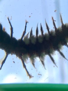
Hellgrammite (DobsonFly Larvae – approx 4cm), click image for video
video by Katee Meckeler
Our Civic Science Approach – You Too Can Think Like A Scientist!
“Civic science” (also known as citizen science, crowd science, crowd-sourced science, volunteer monitoring or networked science) is scientific research conducted, in whole or in part, by amateur or nonprofessional scientists. It has been defined as “the systematic collection and analysis of data; development of technology; testing of natural phenomena; and the dissemination of these activities by researchers on a primarily avocational basis.” It is primarily through civic science – and the work of “civic scientist” volunteer stream monitors – that we gather data about the health of our streams and of the Raritan River. Our civic science work includes:
Water Quality Monitoring – Visual Habitat Assessments
Water Quality Monitoring – Benthic Macroinvertebrate Assessments
Water Quality Monitoring – Sampling for Pathogens
Soil Moisture Monitoring – Soil sampling to gauge soil moisture content (partnership with NASA)
We are inspired in our work by the idea that we are all scientists and that we can all think like scientists. We work to empower the public with the idea that they are capable of understanding and evaluating scientific evidence on their own. And we are inspired by thinkers like Rush Holt, Jr., U.S. Representative for New Jersey’s 12th congressional district (part of the Lower Raritan Watershed) from 1999 to 2015, who reminds us that we can all think like scientists:
“Seminars about communicating science are about how to make your work intelligible to an ordinary person, how to simplify terminology to make it understandable to a normal person, or highlighting the wow factor of some science, like landing on a comet or manipulating atoms one at a time. What’s missing there is helping people understand that they too can think like a scientist, that they too can practice these techniques of evidentiary thinking, of evidence-based thinking.
I think rather than trying to simplify or dress up your research and explain it to others, we need to put more attention at getting to the essence of science that is the part of what every scientist does. That is asking questions in a way that is done on the basis of evidence, seeking empirical answers to questions, and open communication and verification of your findings. Then you have science. Anyone can do this, even a third grader. Actually third graders do this on their own until we tell them to do otherwise. What’s the essence here is understanding, evaluating, and communicating evidence.”
— Rush Holt, Jr.
Visual Habitat Assessment
The LRWP focuses visual monitoring efforts on the streams and tributaries of the LRW. Individuals and groups “adopt” a stream segment for regular monitoring from June-August every year (one observation per month). The LRWP hosts visual habitat training sessions in May and provides supplies and support to our civic scientist volunteer monitors. We encourage the individuals and groups that adopt the stream segments to make note of significant trash or erosion issues, the presence of invasive species, and to observe the need for restoration. Volunteers are asked to commit to a full season (May-August). If the group is interested we are happy to help organize stream clean-ups, invasives removal, and to help plan for restoration work.
We are always seeking volunteers!
Do you like biology? Are you the outdoors type? Can you survive mosquitoes, black flies, and potentially ticks jumping on you at every chance they can? Well, if so, then consider working with the LRWP on conducting visual habitat assessments for stream corridors throughout the watershed or in your hometown. The LRWP will teach you and certify you in visual habitat assessment scoring criteria to help us determine how healthy a stream corridor ecoystem is for fish life, aquatic insects, wildlife, and animals in general. This is a great opportunity to go on hikes along your local streams, document what they look like, what you see around them, what you see in them, and to take photos of your pathways. Visual Habitat Assessments are the core of LRWP monitoring activities.
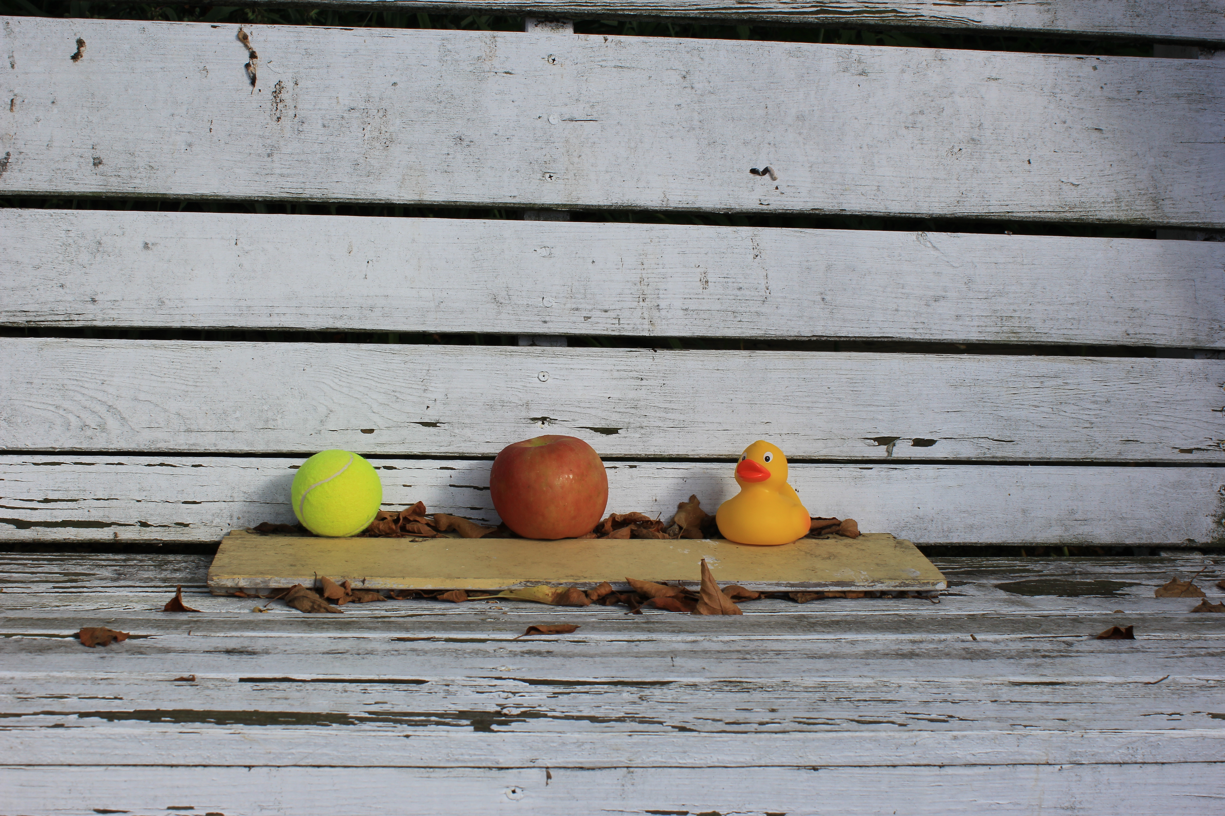
Visual stream assessments don’t require expensive technical tools, but we have the following available to loan to our volunteers:
-Weighted rubber ducks to help gauge stream velocity (apples or tennis balls should work, too)
– Digital field thermometer for measuring water temperature
– 100ft fiber reel measuring tape for stream width measurement
– Bright orange stake flags for measuring off 10 feet for stream velocity measurement
– Measuring stick for stream depth measurement
Benthic Macroinvertebrates Assessment
Do you like streamwalking? Are you fascinated by the animals that live in our waters? Do you want to learn more about them? Then perhaps benthic macroinvertebrates assessments will be your thing. The LRWP will teach you and certify you in benthic macroinvertebrate assessment (catching, identifying and counting the organisms that live in the water) to help us identify water quality trends. Surveys of aquatic insect communities can be used to identify areas of concern within streams and rivers, as they can reflect the presence of non-optimal conditions that other measurements (such as chemical monitoring) might miss. Individual stream sites can then be ranked from best to worst, in comparison to reference conditions, and priorities can be set for their improvement.
What are macroinvertebrates? By definition, macroinvertebrates are organisms without backbones, which are visible to the eye without the aid of a microscope. Aquatic macroinvertebrates live on, under, and around rocks and sediment on the bottoms of lakes, rivers, and streams. As a result of their habitat choice, macroinvertebrates are often regarded as “benthos” which refers collectively to organisms which live on, in or near the bottom. Examples of freshwater benthic macroinvertebrates include the immature and adult stages of many different types of invertebrates. A freshwater benthic community may consist of the immature stages of many flies, beetles (adults and juveniles), mayflies, caddisflies, stoneflies, dragonflies, aquatic worms, snails, leeches and numerous other organisms that inhabit the benthos. Because of the limited mobility of macroinvertebrates and their relative inability to move away from adverse conditions, the location of chronic sources of pollution often can be pinpointed by comparing communities of these organisms. Check out the video below of a macros sample catch from the Raritan River.
Pathogens Monitoring
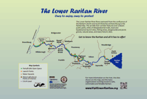
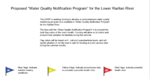
Our focus for pathogens is on monitoring Raritan River recreation access points (see map below) to provide information about the safety of recreating in the water in these areas. In Summer 2016, working with NY-NJ Baykeeper and other partners, we conducted pathogens sampling for 20 weeks at three access sites in Perth Amboy and one site in South Amboy. We look forward to expanding this program, with the goal of regularly communicating pathogens counts to the Lower Raritan Watershed community.
Other Civic Science studies in the Lower Raritan Watershed
NASA’s soil moisture monitoring program – volunteers needed!
The LRWP is participating in NASA’s civic science study on soil moisture as part of the “Soil Moisture Active Passive” (SMAP) civic science monitoring exercise. This involves taking monthly soil samples to link on-the-ground observations with those of an orbiting observatory that measures the amount of water in the top 5 cm (2 inches) of soil everywhere on Earth’s surface.
The topsoil layer is the one in which the food we eat grows and where other vegetation lives. Moisture in the soil indirectly affects us in a variety of ways. In the course of its observations, SMAP will also determine if the ground is frozen or thawed in colder areas of the world.
SMAP is designed to measure soil moisture over a three-year period, every 2-3 days. This permits changes, around the world, to be observed over time scales ranging from major storms to repeated measurements of changes over the seasons. The LRWP is trying to obtain as many soil sample sites from around the watershed to begin to develop a soils database and we need volunteers who are willing to take soil samples 1x a month, dry them and weigh them using NASA protocol. We will train volunteers. Please contact us if you or your school is interested in participating.
Here’s a great article that provides more information on SMAP and the need for soil sampling.
We are fundraising to participate in the web-based training program “Monitoring That Guarantees Measurable Results” (sponsored by the nationally-known River Network). This program will give us the assistance we need to develop a comprehensive monitoring plan for the Lower Raritan Watershed including a data inventory, a blueprint for monitoring objectives, an information delivery plan and a monitoring program evaluation plan.
