(Making) Room for the River: Applying Dutch River Management to the Raritan
Article and images (except as noted) by Sanja Martic, Rutgers Department of Landscape Architecture Graduate Student.
“Man wants to take the river’s natural storage reservoir and make no compensation for it. The river contends it is against Natural Law and cannot be done. The river is right.”
James P. Kemper, New Orleans, 1927.
The Dutch Room for the River Program (RfR) was conceived in 2007 as an integrated river basin management strategy for the low-lying flood prone and densely populated areas of the Netherlands. As part of this Program, water management is conducted via a specialized regional “Water Board,” working in partnership with the Dutch National Ministry and the Ministries for Transport, Public Works and Water Management. Through RfR the Dutch Water Board takes a four-pronged approach to water management. The four key characteristics of the RfR approach include: 1) large scale river region landscape architectural design thinking; 2) a focus on collaboration, with landscape architecture playing a facilitating role; 3) considering the landscape as a system of layers; and 4) anticipating that natural processes will change and enhance the design over time.
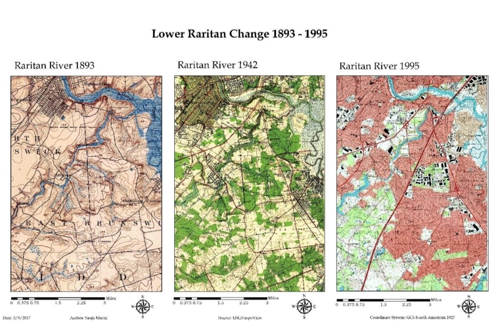
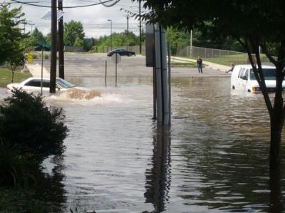
As in the Netherlands, significant portions of New Jersey’s Lower Raritan River are in low-lying densely populated areas. Flood protection is of paramount importance and a matter of human safety and economic security. However, the Home Rule focus of New Jersey’s local governance limits the potential for thinking in a landscape context, no comparable “Water Board” serves as coordinating entity for water management, flood control prioritizes human land use layers, and engineering controls trump considerations of natural hydrological processes and flows. There is much to learn from the Dutch RfR example. In what follows we provide background information on RfR, and consider the Dutch Water Management approach in the context of New Jersey’s Raritan River and Lower Raritan Watershed.
Historic Approach to River Basin Management
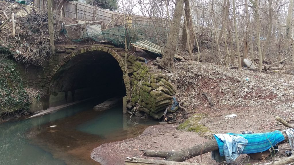
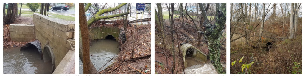
In riverine areas around the world, the industrial revolution demanded capitalization of the river’s territory and its water. As a result, many river basins were heavily engineered: rivers streamlined, river basins minimized, and creeks and small streams culverted or replaced by canals[1]. These practices, in combination with development over time, resulted in floodplains that restricted the river and required repeated heightening of flood defenses[2]. There was no appreciation for the river ecosystems, and water was seen as a threat and as something that needed to be controlled. Over time, conflicts arose regarding use of the floodplain and the its water. And the Industrial Revolution and subsequent development left behind a lasting pollution legacy: abandoned infrastructure and degraded water and soil quality. Meanwhile, the expanding population’s need for potable water and space for a safe habitation increased, causing a decline in the river basin surface. In recent years, rising intensity and quantity of extreme precipitation events associated with a changing climate, coupled with increase of the impervious surface cover, further complicate water management issues.
Room for the River (RfR) Emergence and Approach
In the Netherlands, traditional water management methods were challenged following destructive floods in 1995, caused by record extreme precipitation events. It was clear that new flood levels required a different approach towards river management. Different approaches to water management call for different methods: many rely heavily on engineering while others emphasize a more natural approach. Room for the River Program (RfR) finds a middle ground. Instead of gradually reducing the area that rivers occupy, this approach allows the river to expand over a larger territory[3]. RfR brings together the worlds of water management and spatial planning, engineering and ecology. Tools are varied and include dredging at one extreme, and measuring spatial quality on the other, and they are put into service of two main objectives: improving safety by reducing flooding of riverine areas, and “contributing to the improvement of spatial quality of the riverine area”[4]. Although hard to quantify, this second goal is particularly interesting from the landscape architecture perspective as it considers quality of the space.
Spatial quality within the RfR approach is defined as “a property of the resulting landscape after a plan has been implemented.”[5] A good design is further judged by three criteria: hydraulic effectiveness, ecological robustness and cultural meaning and aesthetics. Cultural meaning and aesthetics criteria call for enhancing the scenic beauty, tailored to a range of sites that could be classified as natural, urban or countryside. Ecological robustness endorses designs that are long lasting, self-sustained, build upon natural processes, and are low maintenance. This is achieved through combining natural hydrology with morphological and biotic processes to achieve stability in riverbed and floodplain.[6] This means that plans have to be functional in the case of floods, but at other times must accommodate livability, wildlife habitats and areas usable as a public good. Design is informal and natural while providing maximum access for recreation, with spaces intended to reveal the spirit of each individual site of intervention.
Room for the River (RfR) Implementation and Practical Measures
In the Dutch model, spatial quality assessment requires development of a special Q-team (quality team) composed of members from different but complimentary disciplinary backgrounds. The Q-team’s role is to produce an independent recommendation on enhancing spatial quality through coaching designers and planners, peer review of the designs and plans, and regular communication to the Ministries of Transportation, Public Works and Water Management[7]. This calls for significant transdisciplinary cooperation between planning and design, with an equal role for the landscape architect, urban planner, river engineer, ecologist and physical geographer. Practical measures (Figure 1) are applicable at large scale and fall into three categories ranked by complexity of integration of flood risk measures with spatial measures. These categories include technical measures (deepening the river bed, lowering groynes, strengthening dikes), measures within the banks (lowering the floodplains, removing obstacles), and measures beyond the banks (high-water channel building, dike relocation, water storage). In addition to evaluating project’s outcome, the team also evaluates the quality of the integrative collaborative design process.
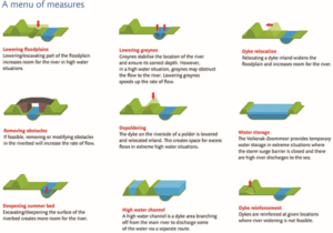
Source: Practical Measures, from Room for the River Fact Sheet
Precedent for RfR in the United States
The RfR approach is not entirely new to the United States. An early similar effort was forwarded in New Orleans in 1927, following devastating flooding events in the Mississippi River delta. Like the Dutch who relied on dikes for flood protection, the Mississippi delta community relied on constant raising and enforcing levees, increasingly restricting the surface size of the natural flood plain. The 1927 flood prompted a reevaluation of the Mississippi River management approach. Official Congressional hearings were held and involved the U.S. Army Corps of Engineers, the Mississippi River Commission and expert witnesses such as Gifford Pinchot[8]. Discussion revolved around engineered control of the river proposed by the Army Corps of Engineers, and an approach in which nature would be allowed more leeway[9] supported by Pinchot, James Kemper and others. The latter view resembles the RfR approach as it calls for allowing more room for the river through widening the flood plain.
RfR Methodology
1. Large-Scale Design (Entire river region)
The large scale landscape architectural design approach considers “not only detailing of small-scale elements, but also at the scale of the river system as a whole”. [10]
2. Collaboration
The landscape architect plays a central role of coordinator between planners, architects and other partners. Fliervoet and Den Born studied and evaluated the RfR’s collaborative process from a stakeholders’ perspective. They concluded that the success of the approach is highly dependent on the cooperation and collaboration of multiple entities occupying the watershed with emphasis on the local knowledge. The biggest obstacles to collaboration stated by the participants, were the lack of an overarching, integrated maintenance vision and a lack of coordination between the authorities.[11]
3. Considering the Landscape as a system of layers
o Basis of Landscape (soil, water, ecosystems)
o Network Layer (roads, waterways energy infrastructure)
o Occupation and Land Use (living, working, recreation)
o Time Layer (all layers develop within their own time scale)
4. Creating Conditions: Responding to natural processes
Natural processes are expected to change and enhance design over time.
Applying the RfR Methodology to the Raritan
Large-scale Design of the Raritan River Floodplain and Regional Network
The first characteristic, the large scale of design as applied to the Lower Raritan, requires creating a comprehensive masterplan with projects spanning the entire Raritan watershed. RfR site plans would become small parts of a large Raritan Watershed Masterplan. The masterplan would be guided by a comprehensive vision of integrated water management, with a regional greenway connection as an integral part. Directly connecting the City of New Brunswick to the greenway network would be a key component of the masterplan, as New Brunswick is the largest settlement on the banks of the Raritan River. Collaboration between many governing bodies is essential. At the federal level the governing bodies to involve include USACE, USCG and the Advisory Council on Historic Preservation. At a state level governing bodies to involve include NJDOT, NJDEP and Land Use Regulations and Ecological Services Field Office. Regionally the Delaware and Raritan Canal Commission and counties such as Middlesex, Somerset, Hunterdon and others should be involved. At the local level the municipalities along the Raritan River banks including New Brunswick, Piscataway, Franklin Township etc. would require representation.
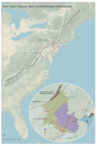
Large scale design requires examination of large-scale network connections. Analysis in the Raritan River context reveals several greenway network opportunities (Figure 2). Metropolitan areas of New York City and Washington D.C. are roughly framed by the Appalachian Trail to the North and the proposed alignment of the East Coast Greenway to the South. They are further enclosed by the major East Coast rivers that bisect the Trail and the Greenway on their way to the Atlantic Ocean. The Hudson River Valley to the East, the Delaware and Lehigh National Heritage Corridor, and the Chesapeake and Ohio Canal to the west all form a regional trail system matrix. This blue and green matrix provides unique opportunities for cross connections of the corridors and interactions with nature and culture to one of the world’s densest contiguous urban populations.
The East Coast Greenway is an aspiring walking and biking route stretching the length of the US East Coast with southern terminus in Key West, Florida and northern Maine. Once actualized, the East Coast Greenway will be 3000 miles long and epitomize the bond between communities and nature by connecting the exist green open space along its route into a unique linear corridor. Initiated in 1991, with forming of the East Coast Greenway Alliance, the vision of Greenway designers, “represents a commitment to public health, environmental sustainability, economic development, and civic engagement”[12].
The existing Appalachian National Scenic Trail, which partially passes along New Jersey’s northern border, is currently the longest hiking footpath in the world at 2190 miles long[13]. It was first proposed by a regional planner Benton MacKaye in a 1921 document titled “An Appalachian Trail: A Project in Regional Planning”. MacKaye’s vision initiated the idea of land preservation for the purposes of recreation and conservation. The idea started to materialize in 1925 and was actualized in 2014 when the last stretch of the Trail was formally acquired and protected. Today, the trail is visited by over 3 million visitors a year as it bisects fourteen US States from Georgia to Maine.[14]
The East Coast Greenway’s proposed alignment crosses the narrow waist of New Jersey using the D&R Canal Park as a major junction. Canal Park’s Masterplan recognizes the most important quality possessed by this linear park to be the role it can perform as a connector. Canal Park no longer links New York City and Philadelphia, but it does join central New Jersey communities, different land forms and different kinds of natural areas, and connects New Jersey with its heritage[15]. Extending the Canal’s connection back into the city of New Brunswick would align with the Canal Commission’s Masterplan and benefit New Brunswick’s future development.
The Delaware and Lehigh National Heritage Corridor runs along the Delaware River on the Pennsylvania side, parallel to the D&R Canal Park. It is an indirect connection between the proposed East Coast Greenway, through the D&R Canal Park to the Appalachian Trail. It is also an example of a linear park run by a nonprofit organization, while Chesapeake and Ohio Canal is a linear park that is part of the National Park system. The Chesapeake and Ohio Canal is another significant connector between the Appalachian Trail and the East Coast Greenway close to a major metropolitan area.
When the Delaware and Raritan Canal was built in the 1930s it permanently linked the Delaware and Raritan watersheds, creating opportunities for connection. Since that time, construction of Route 18 through New Brunswick, which established a several mile stretch of roadway immediately adjacent to the Raritan, severed this historic network connection, in particular in the area between Buccleuch Park and the Landing Lane Bridge. Today, the City of New Brunswick’s unique geographic position could once again benefit future development should access impediments to the D&R Canal Park be removed, resulting in expanded access to not only Canal Park but regional networks like the East Coast Greenway. There would be many mutual gains: the local community would have better access to nature and everyday recreation and day-hiking without having to drive to the trail. New Brunswick’s rich local history would add to the richness of the trail’s experience. The local economy would benefit from hiking and biking traffic generated by the Greenway. Finally, being a part of the future East Coast Greenway’s shared vision could be an invigorating driver of the nature stewardship and future community and economic development.
Collaboration of Local, Regional, National and State Partners
Collaboration and coordination, conducted by a landscape architect, may include working with a variety of professional partners on a local level. In addition to planners and architects, other professions to engage include social scientists, geographers, ecologists, river engineers, biologists, historians, archeologists and civil engineers.
Considering the Raritan River Floodplain and Watershed Landscape as a system of layers
The RfR “system of layers” approach consists of a base layer, network layer, potential for use layer and time layer (Figure 3). Layers provide a basis for site evaluation within the Lower Raritan. Expanding the original RfR methodology, we have conceived of each of the four categories of layers as worth 25 points for a total of a 100-point evaluation system. The lower the score for specific site, the better the opportunity for enhancing it.
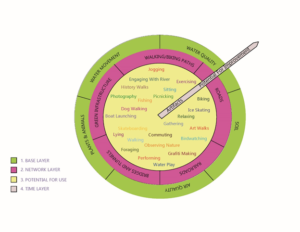
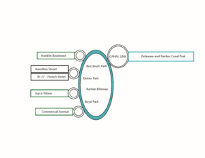
For example, considering New Brunswick in relation to the regional greenway network, the four areas identified as having the best opportunity for creating connections between the New Brunswick and regional greenways are the Key Connector Streets (Urban Core Green and Blue Corridors), Waterfront Access Points, Raritan Bike Path, and the “D&R Canal Link” (Figure 4). These] specific sites should then be evaluated for their soil, water and air quality within the base layer, and for the existing roads, railroads, bridges/tunnels, walking and biking paths and green networks within the network layer. The Network Layer evaluates the existing networks presence and connectivity. Points (0-5) are given for the presence of the networks within the site and more points for their current connectivity. All the sites have a presence of at least one network, however in some cases those networks are enhancing and in others reducing walking and biking connectivity. Increasing connectivity becomes a goal for this layer.
The Base Layer evaluates the soil, water, air, plant and animal life conditions of the landscape. 0-5 points for soil quality are allocated depending on its permeability as well as its ability to support life. In the urban environment soil is often covered by pervious surface or is heavily compacted resulting in a low rating. Water movement is evaluated based on the speed of its movement within the site. Faster movement (poor infiltration) is rated lower. Water quality is associated with the ability of site to treat the stormwater runoff. Water that leaves the site cleaner results in higher points. Air quality depends on the site’s micro location. Sites near major roads with little vegetation are rated lower. Finally, existence of plant and animal life is rated depending on a level of presence. Based on the rating, design goals that emerge are: increasing surface permeability, slowing down runoff by retaining water in the landscape for longer periods, decreasing soil compaction, and creating conditions that support more plant and animal life.
Our addition to the methodology also includes expansion of the “potential for use layer” by which each of these sites are evaluated for their potential to support any of 25 different activities that could take place within the area once it is redesigned. The Potential for Use Layer allocates one point for each activity that can currently take place within an area. The goal for this layer becomes increasing the number of future potential use of the space.
Finally, the time layer evaluates presence of historic and cultural artifacts on one end and a potential for future ecosystem health improvement on the other. Sites that contain historic and cultural artifacts are rated higher, as well as the sites that will be able to, over time, enhance the ecosystem health. Ecosystem health is prioritized over the existence of historic and cultural artifact. For example, a city street has less potential for the improvement of the future ecosystem health than the river bank.
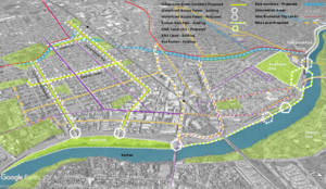
Figure 5: Proposed Connections Diagram
The redesign of the existing key connector streets within the City of New Brunswick enhances the biking and walking experience, while leading to the waterfront access points. Commercial and Joyce Kilmer Avenues are green corridors, chosen for their proximity to the local schools, green open space, highest population density and wide traffic lanes. These two thoroughfares have a great potential for “road diet” interventions, such as narrowing traffic lanes and adding bumpouts at street crossings in order to calm traffic and thus enhance safety of pedestrian and bicyclists. They would further create opportunities for bringing nature closer to the local communities by becoming way finders for the Raritan River as well as the green corridors with more pervious surface and vegetation (Figure 5).
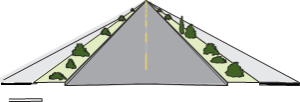
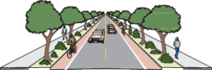
Figure 6: Green Corridor Intervention
Source: Oregon Bicycle and Pedestrian Guide
Route 27 or French Street and Hamilton Street are already main routes of access that are further enhanced by adding new and improving existing bike lanes, and improving pedestrian experience by adding bump outs and lowering curbs. Similar interventions could be applied outside of the immediate study area. Franklin Township’s Franklin Boulevard is the next such opportunity. The existing Mile Run stream corridor, in conjunction with the key connector streets, forms a matrix of river connections. The Mile Run stream corridor is now accessible through this matrix, offering further opportunities for engagement with water and nature.
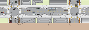
Source: “Main Street: When a Highway Runs Through it”, Oregon Downtown Development Association
Access to the waterfront is strengthened using various traffic calming techniques such as raised, textured crossings, lowered speed limit and narrowed traffic lanes. These approaches ensure safety and an enhanced pedestrian experience. Redesigning the Raritan bike path by adding access points, widening its surface, and adding small, localized interventions helps create a sense of place and wayfinding. Materials and forms chosen for intervention help to further connect community to the unique industrial and postindustrial history and ecology of the place. Finally, the “Canal Link” links fragmented biking and walking paths ending within the area of the River Road, Landing Lane, Buccleuch Park and Spillway, through an elevated walkway bridging the impediments. This walkway becomes the final interlocking link restoring connection to the D&R Canal Park, East Coast Greenway and the Raritan.
A final key characteristic of the RfR program requires considering how including natural change over time can be integrated in the designed system, so that it could start functioning as a natural system. Within the landscape architecture field, time is always an important element considered in designing a landscape. The question: “How will a landscape change throughout the years?” is a core design consideration. However, change is usually considered as it relates to human use and needs. In the RfR case the emphasis is on the health of the entire ecosystem, and the ability of landscape to be “managed” by natural processes, thus making it self-sustained and supportive for all living beings. Choices of materials and forms should be made considering this final concern.[
[1] Wiering and Arts, p 330.
[2] Rijke et al., “Room for the River.”, p 369.
[3] Rijke et al., “Room for the River.”, p. 369.
[4] Rijke et al., “Room for the River.”, p 369.
[5] Klijn et al., “Design Quality of Room-for-the-River Measures in the Netherlands.”, p 291.
[6] Klijn et al., p 292.
[7] Klijn et al., “Design Quality of Room-for-the-River Measures in the Netherlands.”, p 289.
[8] Ari Kelman, A River and Its City, p 190.
[9] Ari Kelman, A River and Its City, p 190.
[10] Way, River Cities, City Rivers, p 376.
[11] Fliervoet, van den Born, and Meijerink, “A Stakeholder’s Evaluation of Collaborative Processes for Maintaining Multi-Functional Floodplains.”,p 185.
[12] https://www.greenway.org/about/the-east-coast-greenway, East Coast Greenway Alliance, 2018
[13]http://www.appalachiantrail.org/home/about-us/media-room, Appalachian Trail Conservancy, 2018
[14] http://www.appalachiantrail.org/home/about-us/history, Appalachian Trail Conservancy, 2018
[15] D&R Canal Park Revised Masterplan 1988, p 32.