by Maya Fenyk (age 11), LRWP youth consultant and “Endangered & Threatened Species” series contributor
Hello! I am Myosis Sodalis, but you can call me Clementine the Indiana Bat. I am an endangered species, which means that I am likely to become extinct. Because of my endangered status, my habitat is considered “critical.” This means that special efforts are supposed to be taken to protect the important characteristics of where I live. I live in caves and roosts throughout the central part of the United States and the East Coast, including parts of New Jersey and the Lower Raritan Watershed.
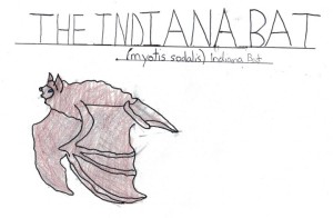
Clementine, the Indiana Bat (drawing by Maya Fenyk)
Some people are scared of me (and of bats in general), but they shouldn’t be. Bats do a lot of work for humans! We are great at pest control, pollination and spreading seeds. Farmers especially appreciate what we do. And if you think about how many pesky mosquitos we eat every night you will start to appreciate us, too! Even though we help out in so many ways there are a lot of issues that make it hard for me and my friends to survive and to do our important jobs. There are lots of threats to our survival – like development near caves and old mines (the places that we stay during hibernation), deforestation of our summer roosts, the use of pesticides, and White Nose Syndrome (WNS). WNS is really scary – it is a fungus that grows on our bodies that leads to starvation and to our freezing to death. Did you know that there are things that YOU can do to help protect me and my habitat? There are things you can do that will make it so that my friends and I can survive and continue to do the pest removal and farming work that helps you humans out!
Before I tell you how you can help out, you should first know a few things about me, like where I live and what I look like. I’m a relatively small bat, only 3.5 inches long. But I have a ginormous wingspan of 10.5 inches! I have black eyes, big ears, a pink nose and very short toe hairs. I also have very strong ridged calcar (the cartilage between my wing joints). I really like to find secret and protected areas to stay with the rest of my maternity colony during the winter months. The maternity colonies – in abandoned mines or caves – are wonderful happy places. I have a lot of friends there. I’m a mommy bat, and the other mommy bats and I work together to keep our babies safe and fed. Unfortunately, over the years a lot of development near caves and old mines has made it really hard for me and my friends to meet together in the large mines or caves that allow us to share the protections of maternity colonies. This means that I often have to find isolated caves to live in, and when I go out to hunt food I have to leave my babies alone without my friends to help me watch over them. As a result my babies end up as easy prey for predators including snakes, owls and raccoons. Development has also affected our summer habitat.
When my kids become juveniles they need time outside of the cave to mature and to learn to hunt bugs and to live on their own. But deforestation and removal of our trees has led to fewer and fewer places for us to safely spend our summers. I do have one favorite summer home on the banks of the Raritan River in New Brunswick – I know that there are protections in place there that keep municipal maintenance crews out of my home during the crucial summer months. Thanks to attention to state laws no one comes in to bother me and my kids!

Indiana Bat Habitat in New Brunswick, NJ (image: Heather Fenyk)
Even though we might not have humans coming directly into our summer homes we still have to deal with poisoned food. That’s right – the White Nose Syndrome I told you about is most directly linked to eating bugs that are sick from pesticides that you humans put on your fields and lawns. WNS creates a fungus that makes my hair fall out, and that covers my nose and makes it hard to eat. And when my hair falls out I might freeze during the winter! Other ways that WNS is spread is by coming into contact with gear that humans carry from cave to cave when they explore our homes.
There are things that you can do to help protect me. These include protecting my habitat, including my winter and summer roosts. My summer roost is in the inside of a dead oak so it is very important that you don’t cut down dead trees unless they are diseased. Not only could that decomposing tree in your backyard be MY home, it is also important to the health of the soil to have the decomposing plant matter enrich the soil. And keep my summer roost clean! But only clean-up during winter months (November through March) so you don’t disturb me while I’m roosting. Please respect my winter roost, too. My pups are experiencing their first hibernacula in our winter roost – a cave. My pups are trying to conserve energy for when it becomes warmer and are very vulnerable if I have to go out to hunt for bugs to feed them. You should know not to come into my cave, and if you do at least clean your gear before you do because WNS can be spread from cave to cave on the gear of humans.
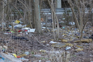
Please clean up my habitat! (Image: Heather Fenyk)
Other ways you can help save my species is to stop using pesticides in your garden, stop cutting down trees and leave the wild as it should be. It’s great to meet you – please look for me at twilight when I’m out hunting bugs. The Lower Raritan Watershed is an especially good place to find me during the summers – it is the middle ground for my long range from Michigan to North Carolina. And if you see me or any of my friends please contact the Lower Raritan Watershed Partnership to let them know. They are working to document Indiana Bat sightings to help to protect our habitat. Now please excuse me. I must go prepare to move for it is the time of year where we are readying our juveniles to head to our summer roost. Clementine the Indiana Bat signing off!
Articles and Photos by Joe Mish

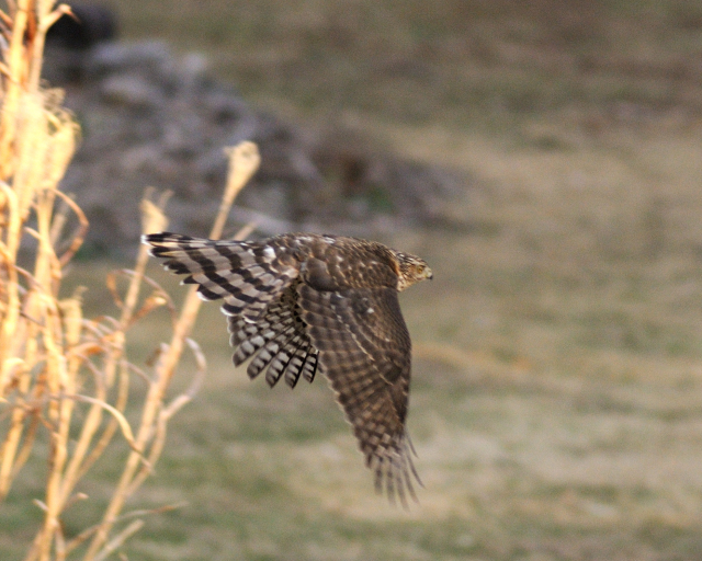
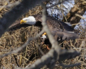
A cooper’s hawk flies off after landing in a holly tree where it jumped from branch to branch in an effort to flush a hiding songbird into the open.
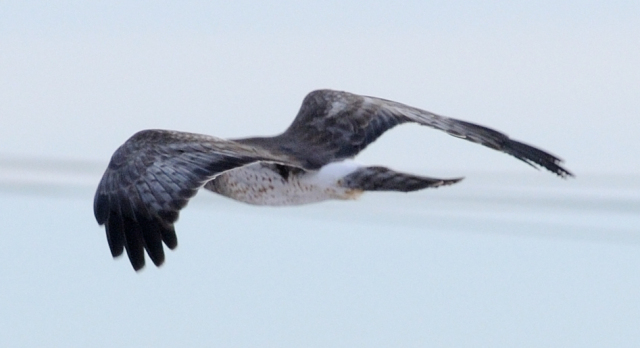
Midwinter is a great time to catch a glimpse of local wildlife, especially hawks, as these large birds stand in dramatic contrast to the gray-brown leafless trees in which they perch.
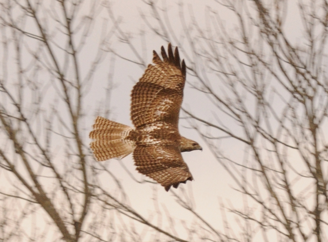
The most common hawk in our region is the red-tailed hawk. Comparatively large, the adults are recognized by the bright russet colored tail. This is the only hawk whose tail is not banded or bordered by a contrasting color. The young birds have barred tail feathers, alternating russet and white, with no distinct borders.

Easy to spot at highway speeds, the light breast and faded red tail stand out like a beacon when perched in trees along the roadway. Locally, I often see these hawks atop telephone poles near pastures and flood plains where they scan the open area for small mammals and ducks. Some red tails specialize in killing gray squirrels, a worthy meal for such a large bird whose energy expenditure in the winter would hardly be covered with mice or voles.
During a winter freeze when most of the river is solid ice, there are always open sections where ducks concentrate in the water and on the ice. A red tail will make an easy meal, especially of the smaller wood duck, flushing it into the air or catching it as it naps on the ice.
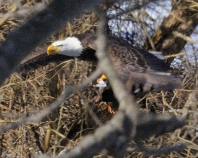
Last winter I watched an eagle feeding on a wood duck, speculation was the eagle took the duck from a red tail as eagles are notorious for stealing game from ospreys and hawks.
Muskrats are also high on the midwinter menu as the males often travel during the day over ice and snow as they seek food and females to breed.
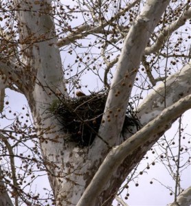
A hawk requires a large nest and now is the time to scan the treetops and high tension towers for these stick built structures. One local hawk has adapted to a giant oak in someone’s backyard bordering a cluster of recently constructed homes. I have seen several local nests situated high in sycamore trees along the river. Hawk nests are relatively flat and large, not to be confused with squirrel nests which are numerous and quite round, generally built at a lower level, among thinner branches. Red tails will also use ledges as a base for their nests.
The ultimate adaptation belongs to the red tail known as, Pale Male, whose life is well documented in film, media and print as he has mated and bred several generations of hawks among the skyscrapers in mid Manhattan. His age is estimated at 24 years. Here is one site dedicated to Pale Male.
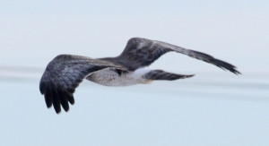
Marsh hawks share the sky with red tails and characteristically conduct ground hugging flights across overgrown fields, flood plains and grasslands and have an ability to hover in place. These hawks are slightly smaller than a red tail with dark brown coloration and a boldly banded tail. The key to identifying a marsh hawk is the bright white rump patch. These hawks are common, though not often seen and are known to migrate while red tails remain as full time residents.
Aside from red tails, the most often seen hawks are the coopers and sharp-shinned hawks. The coopers being slightly larger than the sharp shinned. Both hawks feed on songbirds and small rodents. As each is similarly marked, identification is always controversial. More often than not, someone will submit a photo of a hawk to a website asking if it is a coopers or sharp-shinned and the replies are often split, each summarizing why they made their choice. I see the larger coopers preferring doves and rabbits while the sharp shinned has left piles of bluebird, indigo bunting and flicker feathers about the yard.
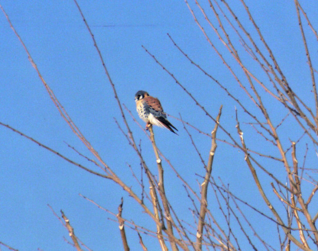
Lastly, look for the diminutive sparrow hawk, now known as the kestrel, typically perched on telephone poles and wires along open fields. This bird is about the size of a large dove, feeds on insects and small rodents. Kestrels are known for hovering before they dive on their prey and this stationary flight is a good identifying characteristic. The males are brilliantly marked with blue, shades of russet, black and white. At first glance a perched kestrel will appear as a songbird so be sure to give a second look. They are considered threatened in New Jersey and a nest box program and monitoring effort is having a positive effect on their recovery. The birds are easily baited and trapped for tagging and data collection.
This is the winter of the hawk and hardly a commute is possible without being evaluated by a feathered predator. They can see you, can you see them?
Author Joe Mish has been running wild in New Jersey since childhood when he found ways to escape his mother’s watchful eyes. He continues to trek the swamps, rivers and thickets seeking to share, with the residents and visitors, all of the state’s natural beauty hidden within full view. To read more of his writing and view more of his gorgeous photographs visit Winter Bear Rising, his wordpress blog. Writing and photos used with permission from the author.
by Heather Fenyk & Elizabeth Dabundo
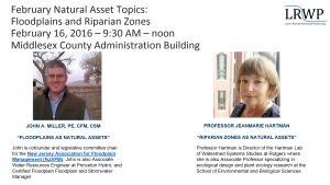
Join the LRWP from 9-noon on February 16th when we will hear presentations on Natural Resource Assets by John A, Miller, Princeton Hydro Water Resources Engineer and co-founder and legislative committee chair for the New Jersey Association for Floodplain Management and Rutgers Professor JeanMarie Hartman, Director of the Hartman Lab of Watershed Systems Studies at Rutgers.
Natural Assets Map Project Background
In February 2015 at a workshop on Impervious Cover Remediation (ICR) co-hosted by the LRWP and Rutgers Cooperative Extension Water Resources, the LRWP recognized a need for tools to help communities implement Green Infrastructure (GI) and meet ICR goals. At the ICR workshop municipal representatives expressed an interest in minimizing stormwater runoff, with many of of these reps suggesting that their communities set impervious cover reduction targets. But where to start? How could towns best prioritize resources for ICR and GI implementation?
To help LRW communities on this path the LRWP researched tools that would help with strategic location of ICR and GI sites. We found references to a process called “Natural Assets Mapping” that suggests not only a prioritization process, but also provides an approach to orienting community conversations around valuation of ecosystem services and the benefits supplied to human societies by natural ecosystems.
Working with input from the Middlesex County Department of Planning we shaped a speaker series for 2016 to guide development of a Natural Assets Map for the Lower Raritan Watershed (Watershed Management Area 9), and to prime municipal conversations regarding prioritization of GI and ICR.
Our goals for the project include:
- To evaluate, prioritize and map natural and cultural assets in the Lower Raritan Watershed.
2. To support community stewardship of Green Infrastructure (GI) / Nature-Based Solutions, including:
-Informing development of GI Master Plans
-Identifying opportunities to add GI to capital projects
-Helping communities link to GI performance rates
-Helping develop design standards for GI related to identified assets.
3. To identify potential investments to optimize the existing system.
4. To advance and support stormwater management planning at County / municipal levels.
5. To improve administration of environmentalism in the LRW.
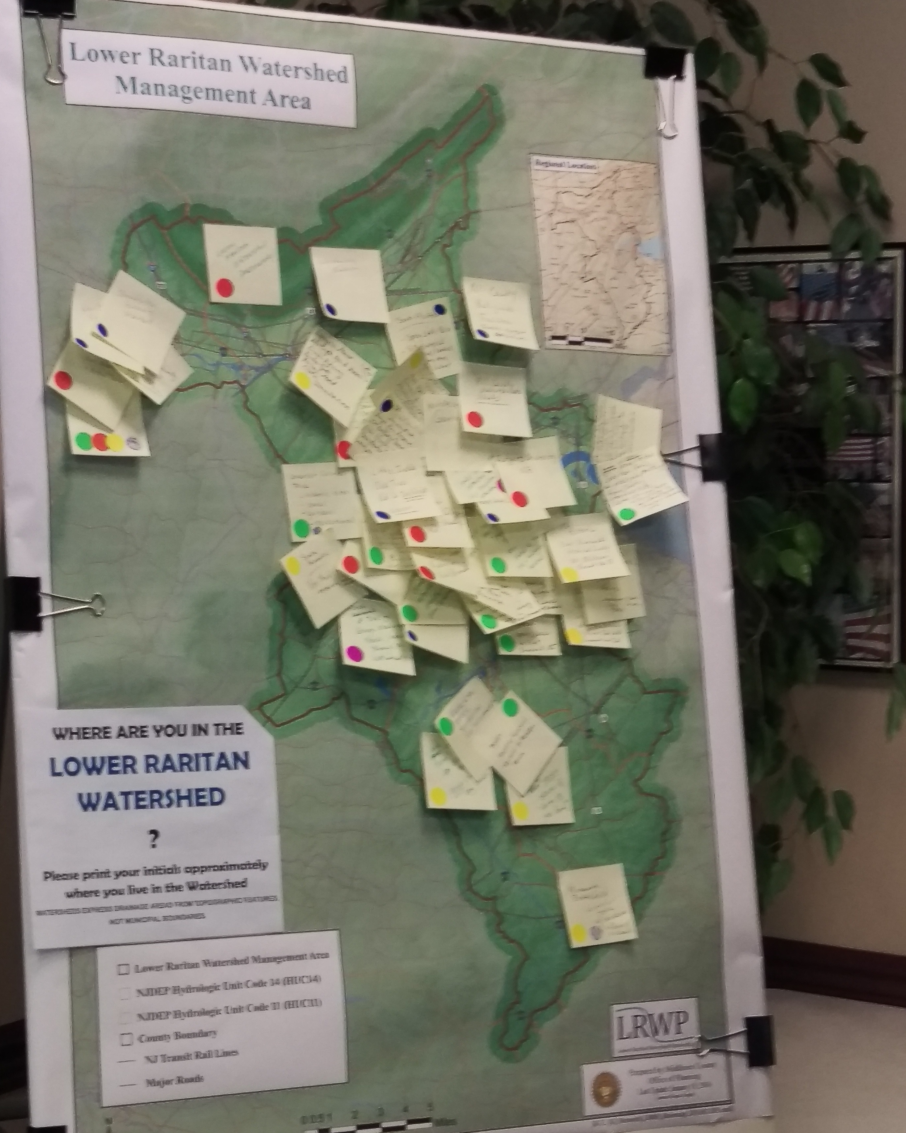
The 2016 Natural Assets Mapping kick-off
At the 2016 Natural Assets Mapping kick-off event on Tuesday January 26, LRWP Land Use Planner Angela Knowles gave an overview of the Natural Assets Mapping process as outlined by Karen Firehock at the University of Virginia. Angela provided highlights of the document we are using to guide our work (“Evaluating and Conserving Green Infrastructure Across the Landscape: A Practitioner’s Guide“) and described the various GIS layers the LRWP plans to discuss going forward.
Angela also explained how, using these layers, we will map environmental, cultural, historic, and human assets throughout the watershed in an interdisciplinary way. With GIS, LRWP communities will be able to see where particular features are found, what geographical patterns exist, and what changes have occurred over a given time period. We aim to identify the natural assets in the watershed and how they relate to other community assets so that we can conserve, and/or restore the natural features that are most valuable to communities. This further reduces the need to build engineered structures to deal with issues like stormwater runoff in favor of more cost effective, natural solutions.
At the kick-off, attendees brought attention to various environmental, cultural, historic, and human assets that they personally thought were valuable in a group mapping exercise. The LRWP will devote much of the year to reaching out to community members around the LRW to pinpoint certain areas that may be less known to many, but no less valuable.

Speaker themes for 2016 include natural resource assets, cultural and historic assets, transportation and mobility assets, seeing brownfields as community assets for restoration, and economic assets, innovation, & regional planning. We are very excited for the opportunity to have state and regional experts on these topics join us for these presentations, and we hope you will join us as well! Please see our events page for more information.