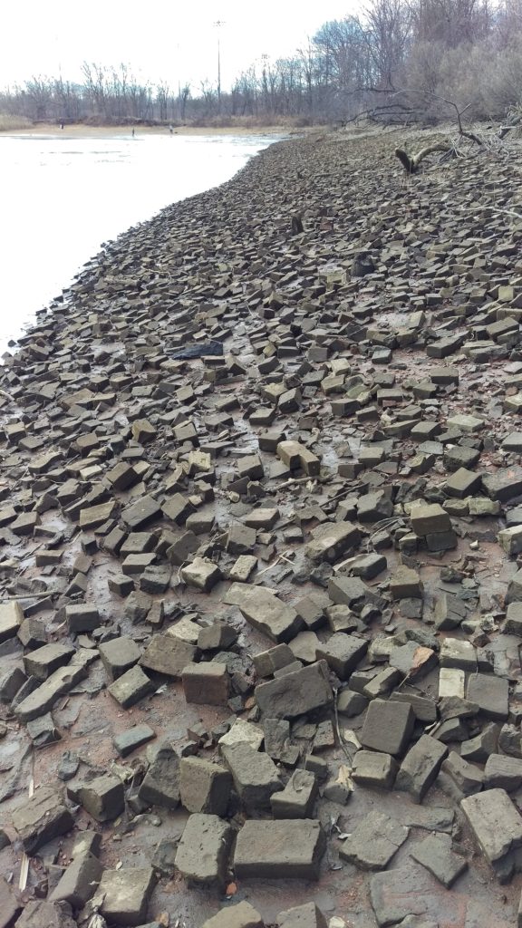
On March 16 the LRWP hosted a clean-up of South River’s Grekoski Park and the adjacent floodplain. Despite the biting wind we had a good turn out, and cleared several dozen bags of trash and plastic from the floodplain, stream, lake bottom, lake’s edge, and wooded areas. While we cleared out hundreds of plastic bottles and dozens of tires, we did not contend with the significant legacy industrial dumping issues at the site, perhaps the most visually striking of which is South River’s “Brick Beach.”
South River’s “Brick Beach” photo taken during the LRWP’s March 16 clean-up of Grekoski Park
This brick-strewn tidal floodplain is an especially curious aspect of central New Jersey’s industrial legacy. The American Enameled Brick and Tile Company operated at this site from 1893-1934, and many of New York’s brownstones and subways were made from our Lower Raritan clay. My father-in-law’s first job in America was as a brick maker just across the river at the Sayre and Fisher Brick Company.
The American Enameled Brick and Tile Co. was established in 1893 in South River by Julius Steurberg, his son Herbert Steurberg, and Francis Booraem. With offices in New York City, they were major players in New York City’s construction. In June, 1934, the South River plant was destroyed by fire, never to be rebuilt.
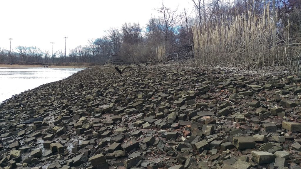
The visual experience here is bizarre: hundreds of thousands of 100+ year old bricks “shoring up” the southern embankment of the South River. The walk across this space is likewise disconcerting. It may look like stable ground but, being tidal (photo was taken at low tide) and heavily silted from upstream erosion, the bricks shift significantly beneath your feet.
The South River floodplain is tidal and heavily silted. Photo taken at low tide.
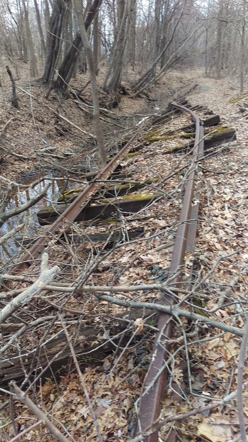
We stumbled across another visually compelling remnant of the the brick industry at this site in the form of an abandoned rail spur. This bit of railway led from from brick manufacture to boats that would travel the short distance along the South River to the Raritan River and across Raritan Bay to New York City.
Neglected rail spur leading from the former American Enameled Brick and Tile Company to boats waiting to ferry bricks to Manhattan.
This is the first of three articles in a series about stormwater management by Kate Douthat, a third year PhD candidate in the graduate program of Ecology and Evolution at Rutgers. Kate’s research is examining the plant communities that have formed in urban stormwater systems. She is interested in the extensive stormwater infrastructure network in New Jersey and how we can use plants to improve water quality. Kate loves to share her enthusiasm about plants and to teach the public about the stormwater systems in our backyards. She has agreed to develop a series of informative blogs for the LRWP’s readers and will also lead our #booksfortheriver book club starting Fall 2019. You can see more of her writing about plants and water resources on katedouthatecology.com
When it rains, water runs
across roads, parking lots, and lawns, picking up pollutants and debris. In
order to prevent flooding in developed areas, where the soil is not absorbent
because it is covered by pavement or buildings, this runoff, termed “stormwater,”
is channeled into storm drains. In nature, wetlands play an important role in
the landscape as regulators of flood waters and sinks for excess nutrients and
pollutants that are swept up in storm water. Green infrastructure is an
approach to water management that mimics natural storage and filtering
functions of wetlands by using plants and soils rather than drains and pipes.
We don’t yet have a good understanding of which plants are best suited to green
infrastructure, so that is the topic of my research.
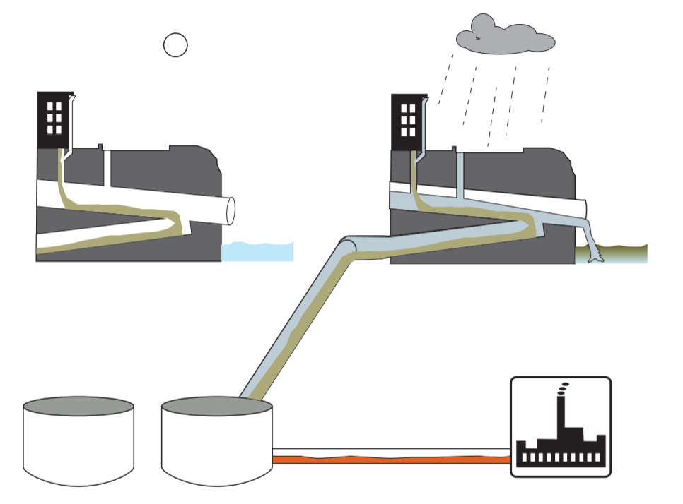
Once stormwater enters a drain, it can have different fates. One type of municipal sewer system is called a combined sewer system. A combined sewer system combines sewage from your house (toilet sewage) with stormwater runoff from storm drains. This creates a large volume of contaminated water that must be treated at water treatment plants. This type of system is more common in older cities in the U.S., and in 21 cities in New Jersey (https://www.nj.gov/dep/dwq/cso-basics.htm). In New Jersey, most combined sewer systems are in cities near NYC, and a few around Philadelphia. The NJ Department of Environmental Protection hosts a web map to show those locations.
Figure 1 A combined sewer system. On the left, in dry weather, sewage goes to the wastewater treatment plant. On the right, in the rain, stormwater combines with sewage. The volume is too much for the pipes and wastewater treatment plant, and a mix of stormwater and untreated sewage overflows to the river.
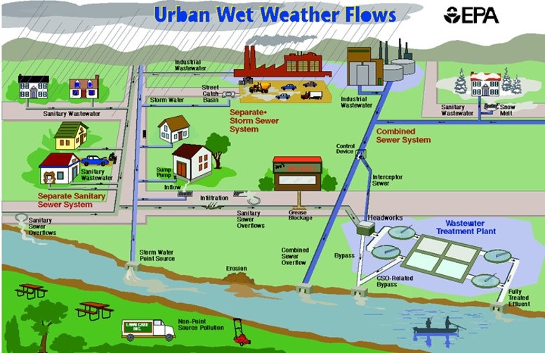
The second type of sewer system is a separate system. A separate system keeps sewage containing human waste in one set of pipes, and stormwater runoff from storm drains in another set of pipes. The latter has the the witty nickname MS4 (municipal separate storm sewer system). The sewage goes to a waste water treatment plant, while the stormwater is released to streams or rivers. This relieves pressure on waste water treatment plants and prevents overflows of untreated sewage. However, stormwater is usually contaminated with all of the urban dross it picks up, including pet waste, leaked gas and oil from our cars, excess lawn fertilizers and pesticides. Stormwater moves more quickly over smooth, paved surfaces than rough natural ones, so stormwater can accumulate quickly and cause floods.
Figure 2 An illustration of the different types of sewer systems. On the left: separate storm sewer system. On the right: combined sewer system.
In New Jersey and many places in the U.S., water from storm drains is temporarily stored in artificial detention basins or ponds before draining to streams and rivers. In principle this prevents the water from a rain storm from concentrating in a stream all at once and flooding its banks. A detention basin receives water from the storm sewer, then passively allows it to drain out the other side. The outlet pipe is small though, restricting the water leaving the basin to a low, steady volume. Detention basins were originally designed for flood control, but we are now realizing that they could be redesigned to provide more functions. The expanded functions for detention basins include pollutant filtering, ground water recharge, and provision of habitat.
Most detention basins are lined with grass that is mown weekly or biweekly like a lawn. In order to increase the functions of the basin, managers are changing to a mix of dense vegetation that is mown annually. This simple change can have a big impact and is the subject of my research. In my next post I’ll talk more about why I’m interested in studying detention basins, what I hope to find out, and how it can change our watershed for the better.
Article and photos by “Voices of the Watershed” Contributor Joe Mish
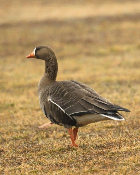
A white fronted goose, rarely seen west of the Mississippi river, enjoys grazing on central New Jersey grass.
Long before President Eisenhower signed the interstate highway bill into law in 1956, The Atlantic, Central and Pacific flyways served as major superhighways for migrating birds.
The primary exit ramps for these super flyways are the rivers which radiate out along the north-south migration routes to distribute the migrating birds far and wide.
New Jersey sits directly on the Atlantic flyway, bounded by the Delaware River and the Atlantic Ocean. Within the state’s interior flows the Raritan River, the longest inland river in the state which serves as a major migratory off ramp.
The confluence of the North and South Branches may then be considered the prime visitors center and rest area, as birds funnel down the Raritan to disperse inland.
Look at a colored distribution map in any bird book and discover that many species are specific to defined regions.
You might not expect to see a rufous hummingbird from the northern Pacific coast, sipping nectar in central New Jersey. However, in 2012, a rufous hummer showed up in our midst and stayed the winter, surviving by the kindness of human intervention. Marlene Scocco reached out to this wayward hummer providing food and shelter, causing a stir in the birding community which gratefully documented this migratory anomaly.
Checking the records for rare hummingbird visitors to New Jersey, other hummer species like the calliope and green violet eared were also documented.
How these birds end up on the east coast is pure speculation. The point is they do and they are here for you to discover.
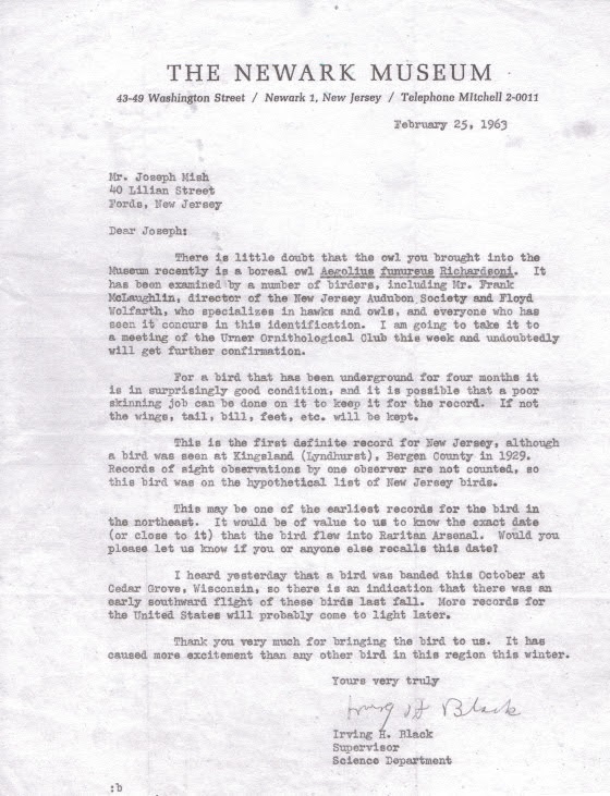
Feathered visitors from faraway places to the Raritan valley are not just limited to hummingbirds. In 1963 I was handed a small owl taken from a guard tower in the Raritan arsenal. It died shortly after. I mentioned this to a friend’s dad who was an avid bird watcher. Told him it was a boreal owl. He smiled and assured me it was probably a saw whet owl. We ended up at the Newark Museum and showed it to the curator, Irving H. Black. Confusion ensued and experts from across the country were consulted. The experts concluded the bird was indeed a boreal owl. It set a new record for the southernmost sighting in the US. The boreal owl, briefly known as the Richardson owl, is a fulltime resident of the coniferous forests of the arctic region. The owl is preserved as a study skin at the Newark museum.
The visitors keep coming. In mid March of this year I noticed an inconsistency in the color pattern of a flock of grazing geese, as I drove by. The geese blended together in one giant mosaic, painted with repetitive splashes of black, white and brown. I pulled over and focused on the colors that didn’t belong.
I was looking at a white fronted goose, another bird that was obviously unfamiliar with distribution maps found in bird books.
The white fronted goose is rarely seen east of the Mississippi river, the main artery of the central flyway. To see a white fronted goose in central NJ is therefore an unexpected surprise and evidence that nature has a tendency to violate scientific generalizations.
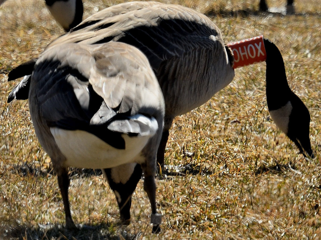
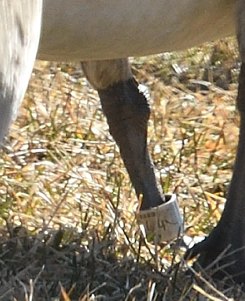
The following week, a Canada goose with an orange and white collar marked OHOX was observed along rt 22. It also had a metal band on its left leg. While editing images, I was shocked to see the goose standing next to it also wore a leg band. Reporting this goose to the USGS bird banding website I was provided with a certificate noting that the goose was a female, banded as a flightless gosling near Varennes, Quebec, Canada on the Fourth of July, 2016.
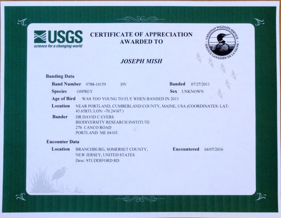
Adding to the distinguished list of local visitors was the osprey I observed April 7, 2016, just upstream of the confluence of the North and South branch. The osprey had a blue plastic band on its left leg, with stacked letters, DV, visible on one of the images taken. Again, making a report to the USGS banding website, a certificate soon arrived, stating the osprey was born on a bulkhead in Portland, Maine and banded on July 27, 2011. To report a banded bird, visit the USGS bird banding website, bandreports@usgs.gov
The spring migration is now in full swing. And along with colorful warblers, ruby throated hummingbirds, woodcock and osprey, come the errant travelers.
Diverging from their evolutionary migration patterns, these intrepid winged visitors explode the myth that, “birds of a feather stick together”.
Migrating birds that nest in our region, along with birds just passing through, are now appearing along our waterways. The confluence that forms the Raritan River is the staging area that hosts a feathered extravaganza of unimaginable variety.
Author Joe Mish has been running wild in New Jersey since childhood when he found ways to escape his mother’s watchful eyes. He continues to trek the swamps, rivers and thickets seeking to share, with the residents and visitors, all of the state’s natural beauty hidden within full view. To read more of his writing and view more of his gorgeous photographs visit Winter Bear Rising, his wordpress blog. Joe’s series “Nature on the Raritan, Hidden in Plain View” runs monthly as part of the LRWP “Voices of the Watershed” series. Writing and photos used with permission from the author. Contact jjmish57@msn.com. See more articles and photos at winterbearrising.wordpress.com.
Thirty years ago, my husband and I moved into a house down at the end of a quiet street in Highland Park. Beside the house, in a low area, ran a little stream, nameless as far as I knew. I imagined making a garden beside it until I saw the muddy water that rushed through after heavy rains, rooting out vegetation, clawing away at the stream banks, and depositing all manner of storm debris. I came to think of the stream as nothing but a source of problems. Years went by. I sought advice from various experts and made some progress in resolving some problems, though others remained.
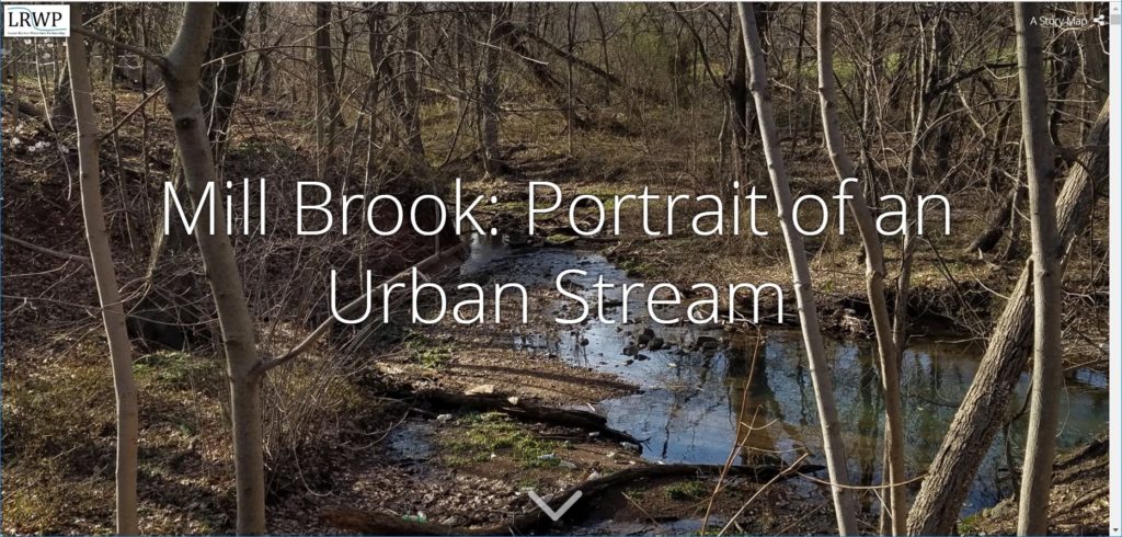
Eventually, in the Rutgers Environmental Stewardship program, I learned that the problems of urban streams are predictable and can, at least in theory, be mitigated. I learned that, with active community involvement, even large rivers have been significantly restored. The RES program led me to the Lower Raritan Watershed Partnership and a plan to document the stream that I now knew was called Mill Brook.
I took pictures and made lists of storm sewer outfalls, eroded portions of stream banks, retaining walls in various states of disrepair, and multiple types of litter, wondering how this information about predictable problems might be useful. Increasingly, my attention was caught by the magnificently tall trees in the Mill Brook stream corridor, the bird song high above me, the calming gurgle of the water at my feet, and the sense of being far away while actually only a few yards from the hubbub of one of the most densely populated regions in the United States. I have learned that Mill Brook has been a source of much happiness for others, too, over the years.
I composed this Story Map Mill Brook: Portrait of an Urban Stream to invite you, the reader, to experience for yourself this valuable natural resource that runs like a ribbon through our community. I hope that a virtuous circle may arise in which the value of Mill Brook is acknowledged in our communities so that we willingly do what it takes to resolve problems created by developments that include our own homes. In return, Mill Brook will increase in value to us because it is a healthier natural resource and because we will have the satisfaction of caring for it.