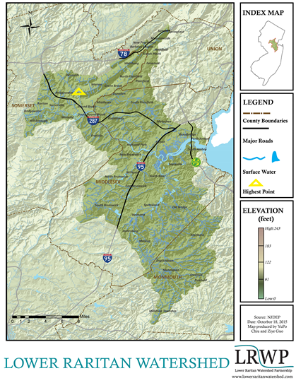
The Watershed
The Lower Raritan Watershed, New Jersey’s Watershed Management Area 9 (WMA9), is home to 846,446 residents (2017).
At 352 square miles, the Lower Raritan Watershed/WMA9 includes the Watchung Mountains to the Northwest, the coastal plain to the Southeast and the lowest point of the watershed at Perth Amboy and the Raritan Bay. Adjacent watersheds include the Upper Passaic to the north, the Arthur Kill and Monmouth Watersheds to the east, the Millstone to the southwest, and the North & South Branch to the west.
The northwestern section of the Lower Raritan Watershed lies within the Piedmont province while the south eastern portion of the watershed lies within the Inner Coastal Plain province. Major Waterways include the main stem of the Raritan River, Green Brook, South River, Lawrence Brook, and Manalapan Brook.
The Lower Raritan spans four Counties including Middlesex, Monmouth, Somerset and Union, and parts of fifty municipalities.
Significant open space areas include Thompson Park, Jamesburg Park and the Monmouth Battlefield.
Major Highways include Interstate 287, the New Jersey Turnpike, US Highways 1 & 9, and State Routes 18 & 28.
Do you live in the Lower Raritan Watershed? Check out our interactive map to find out!
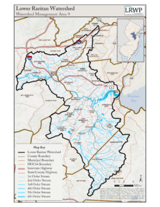
LRW Sub-watersheds
WMA9 is itself made up of six major watersheds, including the Lawrence Brook to the southwest of New Brunswick, and three watersheds along the Raritan, from the convergence of the North and South Branch in the northwest, down to the Lower Raritan, below Lawrence extending to the east and to the Raritan Bay. Read more….
History of the Watershed
Land Cover and Habitat
