Join LRWP Board Member Professor David Tulloch as he leads our second “Watershed Highlights and Hidden Streams” walking tour of 2019!
Professor Tulloch will help us connect the old constructed landscapes of the canal at Duke Island County Park through a new greenway / bikeway that has been developed along the Raritan and crosses over into the Duke Farms properties. Many area residents are likely familiar with individual pieces of these recreation spaces. Fewer have made the walk to connect them all.
We expect to traverse 3 municipalities (and a named community that locals assume is a 4th municipality), and learn about the role that James Buchanan Duke played in shaping the hydrology of the area including creating multiple dams on the Raritan River to channel water to man-made lakes on the Duke Farms grounds.
Professor Tulloch says: “With the pump house and former dam, I think this will really be more about history than the hidden streams. But there are some interesting spots along the river where small streams contort themselves to cross the greenway.”
Join us from 9-11 AM on Saturday May 18.
Please park at the lot marked as the Raritan River Greenway on Old York Road between Woodmere St and Chestnut St, just barely inside Raritan Borough.
Registration required.
As we will not enter into Duke Park lands, dogs are allowed on this walking tour.
Article and Photos by Margo Persin, Rutgers Environmental Steward
Editor’s Note: In 2018 Margo Persin joined the Rutgers Environmental Steward program for training in the important environmental issues affecting New Jersey. Program participants are trained to tackle local environmental problems through a service project. As part of Margo’s service project she chose to conduct assessments of a local stream for a year, and to provide the data she gathered to the Lower Raritan Watershed Partnership (LRWP). Margo keeps a journal of her experiences, excerpts of which are included in the LRWP’s “Voices of the Watershed” column.
As my year-long project entailing the assessment of the Ambrose Brook is now drawing to a close, I wanted to make one last observational visit to the site, which I completed on 31 December 2018. As I was driving over, in my mind I reviewed the year and wondered, at this point in the process, if there would anything more or new that I could possibly say about the Ambrose Brook. Well, was I in for a surprise, and a most captivating one at that! I arrived at just about 10:30 am, I was the only human around, and as I traversed the eastern side of the stream, I spied just one pair of mallards afloat on the lazy, meandering brook. The male’s plumage was blatantly obvious against the muddy, slow-moving current, whereas the female’s was camouflaged just about perfectly with the background: muddy water, brown earth, fallen leaves. The sky was overcast and the air was calm with a moderate 40 degree temperature that provided a welcome and silent capsule for my period of observation. My goal was to walk the bank, if possible on both sides, from a bit past the small waterfall all the way back to the footbridge and back again. And with this trajectory, nature provided me with a series of surprises.
As
I made my way south on the eastern side of the brook, a veritable flock of
mallard pairs came into view, comfortably resting on the water’s surface, the
first that I have seen in the entire year.
They gave me a slight if sneering glance, then turned away from me to
glide closer to the western bank. Secondly, as I walked along the bank farther
and farther from the street noise, I noticed that several trees had a
distinctive series of marks along the base up to about one foot, all around the
circumference of the trunk. I am not a
naturalist, but I wondered if by any chance it could be a family of beavers at
work. “Nah”, I said to myself, this
place has too many people around, “no way”.
Well, I suspect that I was proved wrong!
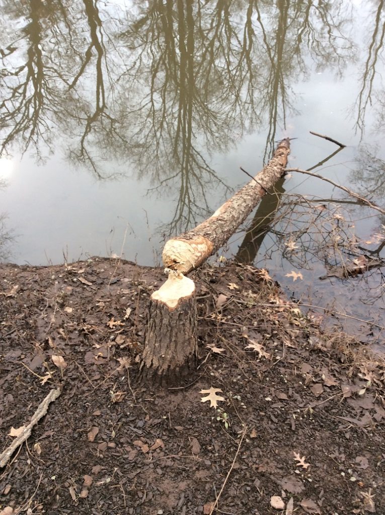
At another spot, a neatly chewed tree, gnawed to what looked like a
precise pencil point, had been felled and now was lying in the water, the
severed trunk just inches from the sad looking stump. “Aha!” I exclaimed, “nature wins again,
beavers’ resourcefulness as effective or more so as a mini-chainsaw”. I never did see any beavers but their handiwork
was a very good indicator of their presence.
At the farthest point away from the street, still on the eastern side of
the brook, felled trees were piled up very close to the water’s edge, and I
wondered whether that might be an indication of a lovely and cozy den. Hmmmm…..
Beaver handiwork. Very impressive!
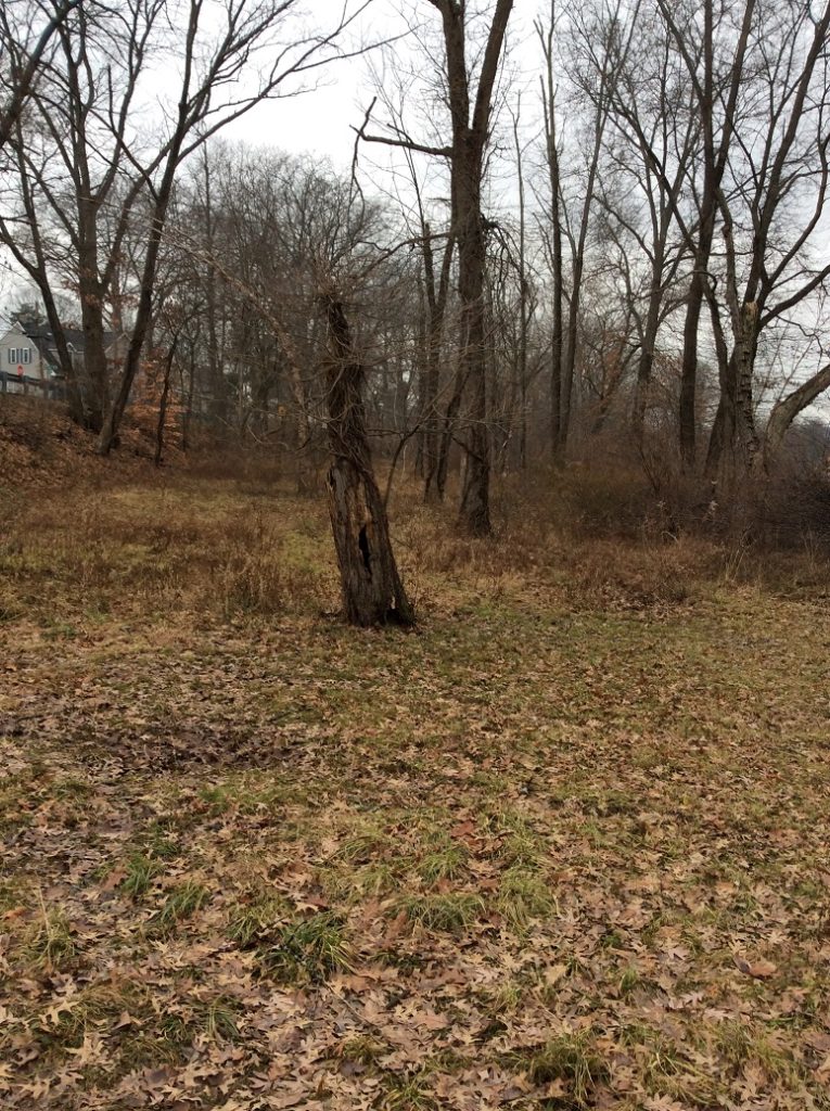
After
crossing the footbridge to the western side of the brook, I was presented with
another of nature’s surprises. Now that
winter is officially upon us and foliage has died back both above my head and
below my feet, I was able to make my way about three quarters of the distance
to the small waterfall. As I walked
among the brown brush, fallen branches, and dormant grasses, it dawned on me
that the brook had on this western bank a lovely and wide flood plain well
below street level that I had never noticed before, given the presence of a
daunting array of vegetation, including some very fierce brambles that had
heartily discouraged my passage in previous visits. Wow!
Talk about hiding in plain sight!
I presume that this flood plain accepts the surplus of storm water that
occasionally overflows the banks of the brook, which is then absorbed into the
ecosystem, but in turn does not flood area streets … or basements. Nifty!
West Bank flood plain, Brook is to the right, street to the left.
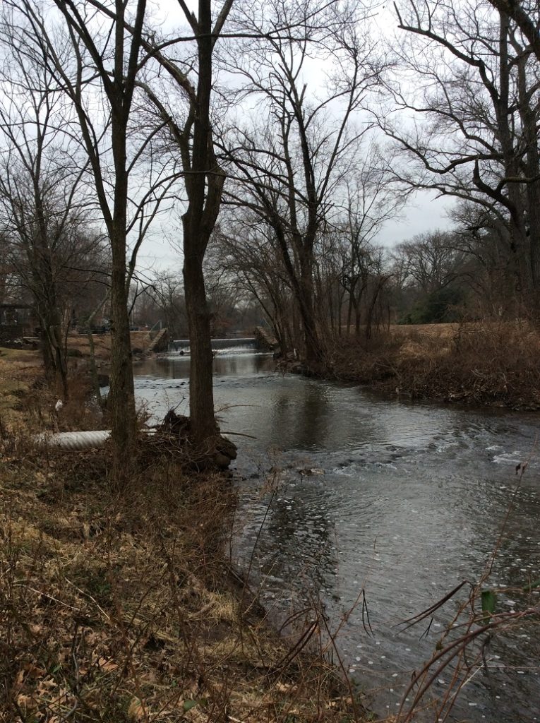
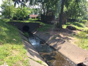
And two last affirmative surprises. Having crossed over once again to the eastern side, I noticed yet another storm water outlet that fed into the brook, close to the small waterfall. I had never noticed it before because of the verdant camouflage offered by the grasses that were presumably fed by its generous flow and overflow. It was right there all the time, but I had never seen it. It humbled me and made me smile – in this visit, I suspect that nature, anthropomorphized to be sure, was having a good chuckle at my expense because of my naiveté. To think that there would be ‘nothing more to see’ was pure hubris and I was given my comeuppance. In addition, the waterfall also had a surprise. Even though the water continues to flow, it was evident that it was starting to freeze at the base! The clumps of white ice shone unmistakably through the tumbling current, a solemn reminder that winter is upon us. I would have missed it if I had not walked closer to the waterfall than I had ever done on previous visits.
Waterfall view in winter. Great for a contemplative moment.
The
last surprise was not a very happy one.
As I made my way on both sides of the brook, I took note of several
places where the water was almost completely stagnant, where the current did
not have the opportunity to lend an active, cleansing presence. And in those small culverts at the water’s edge,
I noted that the water kept a glaze of oil slick of who knows what
composition. At first glance I had
guessed that the water might be beginning to freeze, but upon closer
inspection, the real reason for the discoloration was obvious: water pollution
of a chemical nature. Ugh.
So this was my visit, a combination
of wonder and despair. I plan to offer
in the coming weeks one last report, an estimation of the year’s trajectory as
applied to my original proposal for this project. Happy New Year, everyone! May nature be your guide and live in your
heart.
As we move toward the shortest and darkest day of the year, and as the winter constellations take their places in our night sky, my family seeks out landscapes freed from the trespass of streetlights to check in with Orion, Taurus, Auriga, Perseus, Cassiopeia, Gemini, and Canis Major. These forays are times to marvel at the grandness of the universe, and give us pause to reflect on our place in it.
Winter Constellations of the Northern Hemisphere
Image credit: Carolyn Collins Petersen
However, just like our terrestrial landscapes, even our views of the night sky need protecting. Did you know that fully 80% of the American population lives where they cannot see the Milky Way with the naked eye? Light pollution not only compromises our views of darkness and the heavens, it has implications for functioning of life on earth by changing bat and moth behavior, threatening rainforest regrowth, and contributing to the decline of firefly populations across the globe. Many towns around the world are adopting “Dark Sky Initiatives” to remind us that our lands and skies are interconnected, and that like our waterways and our forests, our dark skies need protecting.
It is the season of lights. Our houses and streets are glowing with color. We string the Christmas trees with miniature glowing orbs, set out the diya, and light the candle in the Menorah. The visual display is joyous, festive, welcoming and wonderful. But consider adding a new tradition to your holiday calendar: turn off your lights and go out to gaze at the brilliance of the winter sky.
My family will do just that during our annual visit to Rutgers’ Serin Observatory during “Public Open Nights.” There we observe the night sky through the 20-inch optical telescope. Barring inclement weather, on December 13, 20 and 27 the (unheated) observatory will be open for two hours starting at 8:30 p.m. We are hoping for clear views of M31, Almach, NGC 457, h & χ Persei, η Persei, M45, M42, Betelgeuse, Sirius, Neptune-Mars appulse, Uranus, and the Moon.
As we scan the skies and take in the vastness of things, remember to take stock of your power to affect positive change in the here and now. Even in urban light polluted areas like the Lower Raritan Watershed there are things we can do to save the stars:
Light only what you need
Use energy efficient bulbs and only as bright as you need
Article and Photos by Margo Persin, Rutgers Environmental Steward
Editor’s Note: In 2018 Margo Persin joined the Rutgers Environmental Steward program for training in the important environmental issues affecting New Jersey. Program participants are trained to tackle local environmental problems through a service project. As part of Margo’s service project she chose to conduct assessments of a local stream for a year, and to provide the data she gathered to the Lower Raritan Watershed Partnership (LRWP). Margo keeps a journal of her experiences, excerpts of which are included in the LRWP’s “Voices of the Watershed” column.
This visit to the Ambrose Brook in Middlesex, NJ took place on a sunny, blustery fully autumn day. I didn’t know what to expect in regard to this visit, given that Hurricane Michael had blown through NJ the previous day. What was most impressive about the site was that it was imbued with a sense of energy and even restlessness, perhaps a carryover from the weather event of the day before. As I wandered along the stream bank, my attention was caught by the wind, strong gusts that kicked up dust and a trail of early falling leaves that scattered along the footpaths, the banks of the moving brook, and settled momentarily on the water. There was plentiful sunshine, open blue sky, a few scattered clouds that gave scant shadow on the earth, but… fall is in the air. The surrounding trees have not yet lost all of their leaves, but it is evident that the summer heat and earth’s natural cycle are performing their annual duty: the tree color is washed out, leaves are drying out and there is more space between the upper branches, as evidence of the drying and falling leaves. The tall grasses at various points on the stream banks have taken on a brownish hue, in contrast with the deeper green of the earlier summer months. Is there a change in the sunlight’s power? I tend to think so. In resting for a few moments on the banks of the stream on a strategically placed bench, I noted that the angle of the sunlight was lower, so the sun’s rays and warmth were mitigated by the obvious change of season, the rotation and tilting of our green planet here in the northern latitude toward winter. Oh, don’t utter the word!
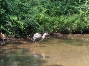
The restlessness that I noted previously can be attributed to the energy that is expressed in the pulsing of the planet via various sources: the movement of the wind, as noted in the trees, grasses and leaves, the rustling and creaking of overhead branches, and the comings and goings of the Canadian geese. For this visit, various groups of geese appeared to be organized into elite squadrons, squawking their arrivals and departures on clearly defined areas of the brook, which took on the function of an aquatic airport, an avian Newark Liberty, as it were. None were to be found on the grass or footpaths. In contrast with earlier visits during spring and summer; for this visit, the geese were supremely active, aggressive even, as if protecting given areas on the water’s surface for their landings and take-offs. I wonder if their ancient memory of paths of fall migration was contributing to their agitation. Their honking and hissing carried from all along the footpath. Other birds that were noted were hearty and intrepid blue jays, who with their size and weight, seemed to be able to tolerate the wind’s gusts and buffeting, as well as a privacy seeking blue heron. The latter was tucked into a quiet shallow at the base and to the side of the waterfall, likely an attempt to avoid and ignore the noisy Canadian geese. (This last comment is a glaring example of anthropomorphism, I know, but those geese really are quite vocal, pushy and …mildly annoying.) Ground squirrels, who appear to be in fine flesh, have begun to heed autumn’s warning, several were observed collecting and munching on the first fall of acorns from the surrounding oaks.
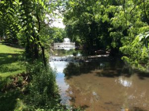
Ambrose Brook was swollen and fast moving, manifesting a steady and plentiful flow, with even some white water at the base of the waterfall. Although I had not brought any measuring equipment for this visit, my ‘guess-timate’ based on visual measurement alone as to water depth was approximately 8-10 inches closer to the bank and 12-15 inches toward the center of the stream and past the small waterfall, surely because of the rainfall from Hurricane Michael. The stream had lots of surface ripples, which acted as prisms for the sunlight, and thus produced a dancing refraction of water, waves, and light. Lovely.
So, this cycle of observation and assessment of mine will soon be drawing to a close. My commitment was for a year’s worth of visits and measurements. Given that I began in December of 2017, only a few more visits remain. Now that autumn is upon us, I am struck by the wholesomeness of this process and how the observation of nature’s constant change ironically demonstrates its sureness and constancy. The beauty of each season does not depend on human intervention – nature and the environment are enough, in and of themselves.
Article and images by Richard Sears Walling, Historic Preservation Planner
October 21, 2018
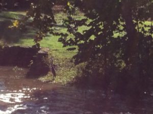
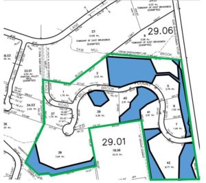
Hickory Swamp – at Hidden Wood proposed development site
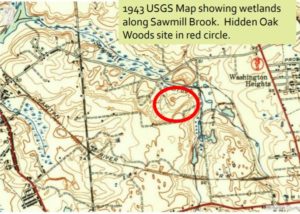
Along the Sawmill Brook corridor, part of the greater Lawrence Brook Watershed and Lower Raritan River basin, remains a unique geological remnant from the Wisconsin Ice Age of more than twelve thousand years ago – Hickory Swamp. This landform is the northern-most example of Pine Barrens in New Jersey. Although the area has remained undeveloped since the time of the Lenape, a major apartment development threatens the destruction of this habitat and poses irrevocable harm to the Sawmill Brook.
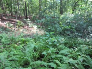
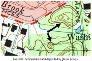
The Wisconsin Glacier ended at what is now the large hill just north of Exit 10 of the New Jersey Turnpike, about eight miles north of the proposed development site. At this point, the glacier was one-mile high, having descended from a height of 3 miles high further north. Beyond this massive glacier was a polar desert, with sand and loess being blown in by the wind from the north at a rate of 65 knots (75 miles) per hour. Wherever sand was deposited in enough quantity to create a habitat, sand barrens were formed. There are barrens at Albany and Long Island in New York, and the northern-most Pine Barrens in New Jersey is the wooded area along the portion of the Sawmill Brook, which runs through Harts Lane.
According to Mark Demitroff, internationally known and respected expert on Pine Barrens geology, this area was formed by proglacial and periglacial activity during the Late Pleistocene. The two dunes present at the site represent a unique periglacial landform resource. These high terraces served Paleo-Indian and later native peoples as natural high ground overlooking Hickory Swamp and the many nearby ponds. Associated natural ponds at Hickory Swamp may, upon further site examination, turn out to be spungs. Professor Demitroff describes the Hickory Swamp area as “having potential value in the study of Carolina Bays, of which Pine Barrens spungs are a variant of. Hickory Swamp ponds mark a transition from a proglacial to a periglacial realm; a little understood interface; at least in a North American context.”
Due to the environmental restrictions of the forty-five acre site proposed for development, there is a checker-board pattern of existing conservation areas. If the site is turned into a literal mini-city (net density of the developable land is over fourteen units per acre, with six hundred parking spaces), these scattered conservation areas will be further fragmented, and partially destroyed by construction activities.
Dr. Emile DeVito, Manager of Science and Stewardship for the New Jersey Conservation Foundation finds that “portions of the watershed which are currently in conservation easements will likewise be degraded and lost. By placing high-density development and impacting current slopes and water-drainage systems that have existed for eons, those natural communities of both fauna and flora will be isolated into small pockets of helter-skelter islands with no chance of moving beyond those small confines. The direct result is obvious, the very intent for which those conservation easements were created in the first place will be negatively affected, and the animal and plant life will be diminished as time goes by, to the point of virtual extinction from their habitat.”
The fight to preserve this unique landform is spearheaded by the Preserve East Brunswick Pine Barrens Coalition. The Sierra Club and the Lower Raritan Watershed Partnership have provided letters of support for conservation of this site, and it is hoped that this forty-five acre tract will be preserved and added to three adjoining preserved open space parcels, all connected by the Sawmill Brook corridor.
The Hidden Oak Woods development application is scheduled for a public hearing before the East Brunswick Planning Board for December 5, 2018 at 8 p.m. in the East Brunswick municipal courtroom. At that time, it is anticipated that the applicant will conclude its presentation and the Coalition will then present the counter case against the proposed mini-city. Interested persons and organizations are welcome to attend. For further information, please find the Preserve East Brunswick Pine Barrens Coalition on Facebook, or email richwalling@hotmail.com. Together, we can ensure that this vestige of our natural history will be preserved for future generations.
The LRWP is pleased to be part of Jersey Water Works, a collaborative effort of many diverse organizations and individuals who embrace the common purpose of transforming New Jersey’s inadequate water infrastructure by investing in sustainable, cost-effective solutions that provide communities with clean water and waterways; healthier, safer neighborhoods; local jobs; flood and climate resilience; and economic growth. The LRWP is active on the Green Infrastructure subcommittee.
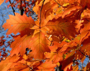
Shades of fluorescent orange, used to color the dawning day, dripped from the palette of the celestial artist to set the autumn woods on fire.
Waves of celestial orange roll over the treetops to set the autumn woods ablaze.
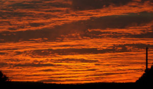
The white, early morning autumn mist hung motionless above the flowing dark water of the South Branch. As dawn approached, the rising sun turned the eastern horizon into a glowing red-hot coal that lit the pale mist with an orange blush.
The trees along the river were immersed in the flood of pre-dawn mist. Some completely hidden and others partially protruding as dark brown silhouettes floating adrift on a misty sea.
As the sun arose, it was as if watching an artist at work laying base colors and adding tints to bring a charcoal sketch to life. The changing light and rising temperature caused the orange mist to vanish as entire trees appeared from the mist, revealing splotches of vibrant fall color.
It is easy to imagine the changing colors of the sunrise were infused into the river mist to wash over the treetops and set their leaves ablaze.
The same spectrum of color seen in the eastern sky at dawn can be found in the fall foliage not flooded by river mist. The full visible spectrum from violet through red and orange, to pink, salmon and yellow are shared as the tree tops meet the sky’s loaded paint brush.
A mere splash of color in early autumn is all that is needed to set the late October woods ablaze. Each living drop of color slowly expands to cover the entire leaf as the season progresses. Its radiance now sets adjoining leaves aglow until the entire woodland canopy is bathed in bright color.
Retreating skyward to a time lapsed satellite view, the expanding colors can actually be seen migrating south. The green foliage appears to be consumed by the advancing flames of the autumnal fire.
Poetic inspiration imagines it is the weight of intense color that causes the leaf to depart the branch.
Gusts of wind stir the treetops to recruit a shower of shimmering color in a free fall final dance for which the tethered leaves had been rehearsing since spring.
The first leaves to fall are contributed by the black walnut and ash trees. Impatient for some reason to drop their leaves. They stand naked among the still well-dressed oak and maple associates just beginning to change color.
A stand of Norway maples grew thick along a low ridge that bordered a sloping cornfield. Their brilliant yellow leaves carpeted the ground and reflected light upward to brighten the understory and set the leaves aglow. The lowest leaves fought for their share of light all season and grew oversized in the effort. The reflected light penetrated the deep shade to illuminate these outsized yellow beacons to celebrity status.
The change of leaf color during autumn has a well-established scientific explanation. Though a longer held belief declared, without question, the color was the work of an ethereal magician.
It is easy to subscribe to that belief when you see a green leaf turn fluorescent orange, a color otherwise unknown in nature. The only place to see that color was in the flames of a fire or in the distant heavens to mark the sun’s arrival and departure.
The fall color is best seen as magic, to set your imagination free and escape to a quiet place where all things are possible.
Author Joe Mish has been running wild in New Jersey since childhood when he found ways to escape his mother’s watchful eyes. He continues to trek the swamps, rivers and thickets seeking to share, with the residents and visitors, all of the state’s natural beauty hidden within full view. To read more of his writing and view more of his gorgeous photographs visit Winter Bear Rising, his wordpress blog. Joe’s series “Nature on the Raritan, Hidden in Plain View” runs monthly as part of the LRWP “Voices of the Watershed” series. Writing and photos used with permission from the author.
Article by Joseph Mish, photos by Joseph Mish and Brian Zarate
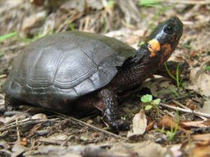
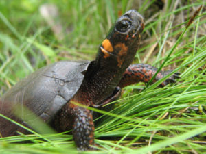
A moment in the sun. The elusive and rare bog turtle, aka Muhlenberg turtle, is captured in this image by Brian Zarate.
The smallest and rarest turtle in NJ has emerged from the obscurity of its muddy bog to celebrity status as the bog turtle was recently named New Jersey’s state reptile.
The bog turtle was first scientifically cataloged by botanist Gotthilf Muhlenberg at the approach of the 19th century. In honor of the discoverer, this diminutive reptile was named Clemmys muhlenbergii. It was commonly known as the Muhlenberg turtle until the vagaries of taxonomic nuance christened it the bog turtle, one hundred and fifty-six years later.
The bog turtle averages a bit less than four inches in length. To visualize its size, write its scientific name on a piece of paper and that length will approximate the size of the turtle.
The blaze orange patch on the side of its head provides unmistakable and instant identification. The orange color glows like a brilliant gem. Stare at it for a moment and the turtle magically materializes from its muddy background.
The overall appearance of the turtle is a grayish black, though on closer inspection there are varying degrees of dull orange skin and freckles especially at the base of the front legs, neck and face. The carapace or ‘top shell’ is covered by ridged scutes or horny segments, comparable to fingernails. Faint amber markings may sometimes be seen on the shell, their appearance dependent on age or accumulated mud.
The small size, secretive habits and specialized habitat requirements restrict the presence of this turtle to very defined regions of the state.
As its name suggest, these turtles prefer open boggy areas fed by clear springs or streams. Skunk cabbage and jewelweed, aka, ‘touch me not’, are easily identifiable plants commonly found in bog turtle habitat. Pasture lands are desirable locations as plants and grasses are kept in check by grazing cows to maintain optimum preferred habitat. Deep mud, constantly infused with spring water, provides ideal hiding places and protection from freezing during winter hibernation.
Tree stumps protruding from the bog and raised islands are preferred locations to lay eggs. Females seek these drier places within the bog to lay eggs as opposed to other turtle species which travel quite far from home.
To illustrate the secret life of the bog turtle, a friend who was a conservation officer, stopped to investigate a car parked alongside a road in north Jersey. He came upon two researchers following signals from a bog turtle equipped with a transmitter as part of a study project. Nothing could be seen to indicate a turtle was present. The signal, however, indicated its precise location and after digging deeply into the mud, there was the turtle alive and well!
Bog turtles are considered to one of the rarest turtle species in the United States.
The bog turtle had been declared ‘endangered’ by the state in 1974 and ‘threatened’ by the US Fish and Wildlife Service in 1997. Population estimates are speculative, as some articles cite the total population in the eastern US as 2,500 to 10,000 and ‘fewer than 2,000’ turtles in NJ. The Bog Turtle Project states 168 colonies have been identified. Equal distribution of 2,000 turtles over 168 locations cannot be assumed and further emphasizes the rarity of this precious gem.
Among the locations identified, there are a select few, which have a large enough gene pool to ensure a viable population into the future. While turtles found in isolated micro habitats are vulnerable to insufficient genetic variation.
In both situations the loss of contiguous habitat is a deadly threat, as a segmented environment limits migration and thus genetic variation as well as exposing animals to predators, mowers and vehicles.
Loss of habitat is a major threat to bog turtles as well as many other species.
Invasive plants, like the familiar purple loosetrife and phragmites, dominate areas to destroy plant diversity and alter soil porosity which in turn eliminates the cascade of insect and invertebrate life upon which the bog turtle feeds.
More turtles may yet be found by wild chance, though by no means can their presence be considered widespread as is the case with more common species like painted and snapping turtles.
Suffice to say the description of ‘rare’ is understated when used to describe the bog turtle.
The designation of ‘state reptile’ is not an endearing term to the general population. I like to think of the bog turtle, as one in a series, of New Jersey’s unheralded natural treasures.
Whenever I see a turtle, I always wonder how old it might be and compare it to events in my life. Most age ranges provided for wild creatures are speculative and based on captive animals or hard data collected from tagged wild animals. A bog turtle tagged in 1974 and estimated to be about 30 plus years at the time was again found in 2017, which places its estimated age at around 65 – 70 years old! That age range allows young and old to ponder what was going on in their life at any point in that turtle’s parallel life.
Thirty something years ago when that turtle burrowed deep into the mud to hibernate, my daughter was born in Muhlenberg hospital. A local hospital named after the son of the discoverer of the bog turtle, aka Muhlenberg turtle. The legislation to proclaim the bog turtle the official state reptile was co-sponsored by Kip Bateman of Branchburg. It would be a further coincidence to find and report the discovery of a bog turtle community within Branchburg!
Author Joe Mish has been running wild in New Jersey since childhood when he found ways to escape his mother’s watchful eyes. He continues to trek the swamps, rivers and thickets seeking to share, with the residents and visitors, all of the state’s natural beauty hidden within full view. To read more of his writing and view more of his gorgeous photographs visit Winter Bear Rising, his wordpress blog. Joe’s series “Nature on the Raritan, Hidden in Plain View” runs monthly as part of the LRWP “Voices of the Watershed” series. Writing and photos used with permission from the author.
The Community Collaborative Rain, Hail, and Snow Network (CoCoRaHS) is looking for volunteer weather observers in the Raritan Basin. CoCoRaHS is a nationwide volunteer precipitation-observing network, with over 15,000 active observers in all 50 states, Puerto Rico, Canada, the Bahamas, and the US Virgin Islands, including over 250 in New Jersey. The NJ program is run out of the Office of the NJ State Climatologist at Rutgers University. Working with the Rutgers Sustainable Raritan River Initiative, NJ CoCoRaHS is looking to enlist volunteers of all ages within the basin. Volunteers take a few minutes each day to report the amount of rain or snow that has fallen in their backyards. All that is required to participate is a 4″ diameter plastic rain gauge, a ruler to measure snow, a computer or cell phone, and most importantly, the desire to report weather conditions.
Observations from CoCoRaHS volunteers are widely used by scientists and agencies whose decisions depend on timely and high-quality precipitation data. For example, hydrologists and meteorologists use the data to warn about the potential impacts of flood and drought within the Raritan Basin.
“Weather matters to everybody –meteorologists, car and crop insurance companies, outdoor enthusiasts and homeowners,” according to CoCoRaHS founder and national director Nolan Doesken. “Precipitation is perhaps the most important, but also the most highly variable element of our climate.”
As Dave Robinson, NJ State Climatologist and NJ CoCoRaHS co-coordinator, notes, “The addition of new observers in your community will provide a detailed picture of rain and snowfall patterns to assist with critical weather-related decision making.”
“Rainfall amounts vary from one street to the next,” says Doesken. “It is wonderful having large numbers of enthusiastic volunteers and literally thousands of rain gauges to help track storms. We learn something new every day, and every volunteer makes a significant scientific contribution.”
CoCoRaHS volunteers are asked to read their rain gauge or measure any snowfall at the same time each day (preferably between 5 and 9 AM). Measurements are then entered by the observer on the CoCoRaHS website where they can be viewed in tables and maps. Training is provided for CoCoRaHS observers, either through online training modules, or preferably in group training sessions that are held at different locations around NJ.
“Anyone interested in signing up or learning more about the program can visit the CoCoRaHS website at http://www.cocorahs.org,” says Mathieu Gerbush, Assistant NJ State Climatologist and program co-coordinator. “We’re looking forward to welcoming new volunteers into the NJ CoCoRaHS program.”
For more information, contact the NJ CoCoRaHS state coordinators:
Article and Photos by Margo Persin, Rutgers Environmental Steward
Internship Diary / June, 2018
So summer is in full swing – I made a visit to the Ambrose Brook immediately after the summer solstice, on 24 June 2018. The environs have changed in several ways, both passive and active. There are several aerating fountains that spray a cool mist that is distributed by the shifting breezes off the water. The highwater mark on the center island has changed since I last visited, probably because of late spring run-off. But the water has even been higher, as evidenced by the residue on all of the banks, the tree roots that extend into the water, and the low-lying bushes. All are wearing a dusty mud color that gives evidence of water that has since receded. Water flow has significantly strengthened, as is noticeable over the modest waterfall close to Rte. 28. In addition, the rain run-off in the two drains has increased, so that more than a trickle from both of them is observable as it enters the brook after the waterfall.
Fauna have increased. One of my prize observations was that of a somewhat lazy or perhaps sleepy but wary blue heron standing on just one leg somewhat in the middle of the stream, past the waterfall. I tried to ease my way in a stealthy and languorous manner along the bank to not call attention to myself, but alas, the heron quickly reacted to my not so subtle approach, was on to me as I slowly worked my way toward the lovely bird . S/he dropped the second leg into the water, turned a cold shoulder in my direction, then deliberately moved away from where I had planted myself on the bank opposite to his/her position. Even though the distance between us stayed about the same, I was so taken by the proximity of this lovely creature and my ability to observe without causing a startled reaction. S/he continued a slow and deliberate saunter down the creek and disappeared around the bend. What a treat to be able to be a silent observer of a stream visitor. Nice!
I also noted that the population of Canadian geese has multiplied to a startling extent. And the birds have become so accustomed to human presence that they barely move when a vertical mammal saunters among them, even when they are settled down and roosting on the grass, the available paths or the cement. In order not to encourage their presence, the township has placed signs that pointedly give the command NOT to feed the waterfowl. Obviously, they greatly outnumber any other visitors to this place, either animal or human. And needless to say, mementos and tokens of their presence are all around, some pleasant and others not so much. An addition to the command to not feed the waterfowl would be “Watch your step and be sure to check your shoes before getting in your vehicle.”
Another observation is that butterflies and moths inhabit the environs, with several Monarchs making their graceful presence known as they fluttered past and through my line of vision. Their wingbeats cast a silent beat to the pulse of the planet as they made their way over and through the environs.
Human presence has also increased. It should be noted that the four walkways that run over and parallel to the stream offer an unobstructed view. And all of them are handicap accessible either all or in part. In other words, on all of them ramps are available so that proximity to the stream can be achieved. People who are fishing on the walkways are only part of the traffic. There were several runners, families with tots and strollers, and other quiet observers to finish out the panorama. My next visit in July will be for another stream assessment, boots, thermometer, floating duck, ruler at the ready Happy summer, everyone!