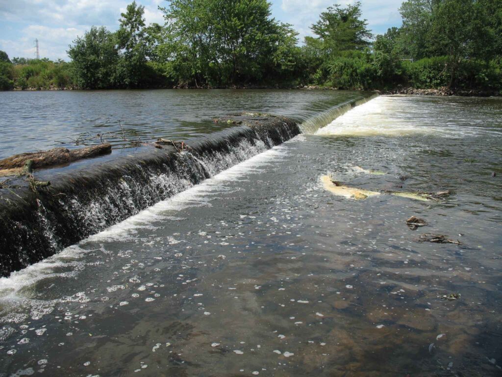
Please join us Saturday, August 14th for a three hour tour of the Headgates, Robert Street and Nevius Street dams. This tour will be led by the very wonderful and informative hydrogeologist John Jengo, PG, LRSP. The tour will include discussion of past and future dam removals, and will be a chance to see the scale of the dams so that downstream removals can be understood in context.
We will kick things off promptly at 8:30 am at Headgates Dam, followed by the Robert Street and Nevius Street dams. We estimate the trip will be approximately 3 hours. We will be walking along the river banks to see these sites, so plan on wearing appropriate footwear. For those interested, we can also visit the Weston Mill Dam site at the end of the day, which can be viewed from the Weston Causeway Bridge.
The LRWP is grateful to John Jengo for offering this opportunity. Registration is limited to 18 people. Directions and parking information will be sent to registrants in advance of the event.
ABOUT JOHN W. JENGO, PG, LSRP: John is a licensed Professional Geologist in several Northeastern and Southeastern states and a Licensed Site Remediation Professional in New Jersey. John works as a Principal Hydrogeologist in an environmental consulting firm in southeastern Pennsylvania. He has degrees in geology from Rutgers University (1980) and the University of Delaware (1982). Over the last 30 years, he has conducted the characterization and remediation of large, complex contaminated industrial sites throughout New Jersey, Pennsylvania, and Delaware. He played a key role in Natural Resource Damage (NRD) assessments that led to groundbreaking legal settlements to remove numerous low head dams on the Raritan and Millstone Rivers to restore historically significant migratory fish spawning runs. As technical project manager, he planned, permitted, and successfully managed the removal of the Calco Dam, the Robert Street Dam, and the Nevius Street Dam between 2008-2013, and the removal of the Weston Mill Dam on the Millstone River in 2017, along with leading the archaeological investigation of the former Weston Mill in the Borough of Manville and Franklin Township.
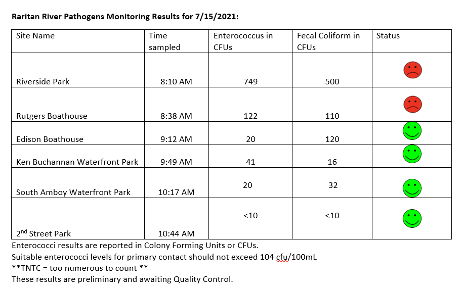
The Lower Raritan Watershed Partnership and Rutgers Cooperative Extension of Middlesex County run a volunteer pathogens monitoring program from May to September every Summer. On Thursdays we collect water quality samples at 6 non-bathing public access beaches along the Raritan River, and report out the results on Friday afternoons. Our results for 7.15.2021 look pretty good! See here for more information on our pathogens monitoring program.
Happy Weekend!
We had a great team out for pathogens monitoring, and put all hands to work catching samples, documenting habitat, and recording data. THANK YOU VOLUNTEERS!!
Surrounded by colorful tree buds, a newborn great horned owl left its nest to begin ‘branching’. The owl will walk, hop, flap its wings and glide short distances in preparation for its first flight, only a few weeks away.
The gentle month of May steps out of character to finally terminate winter’s lease on the land. May does what March and April were unable to do and does it with authority and grace.
Winter has been served an ironclad, last frost warning, and nature celebrates. Delicate plant life now bursts from its dormancy to join their hardier kin who dared unpredictable early spring conditions.
Floral scent now fills the morning air to conjure pleasant memories of warm weather suppressed by winter doldrums.
Walking through the meadow grass, canoe balanced on my shoulders, the scent of multiflora rose fills the air. My path meanders around these thorny bushes and prickly eastern redcedar as if I were bouncing around in a pinball machine.
As I walked into the wind, aromatic meadow grass replaced the floral scent of the scattered bouquets of wild rose. A three-strand barbed wire fence, intended to keep generations of dairy cows honest, now delineated the lush meadow, but could not contain the whimsical direction of the perfumed air. I slid the boat under the sagging bottom wire, laid face down on the grass and inched to the other side.
The river was flowing gently, sun sparkling off its rippled surface which lay just beneath a parallel current of air which carried, intermittent quantums of the unmistakable perfume of black locust blossoms.
Though my olfactory senses were immersed in the current of scent, I had to walk further into the river to set my boat in water deep enough to float, with me aboard. I had to walk-in ankle-deep water to the main channel and each step sent a cloud of muddy water downstream, while upstream, the water ran clear. A pickerel frog escaped my intrusion by lying motionless on the bottom of the shallow water. His spots blending in so well among the small stones. Fresh water clams showed telltale depressions in the mud that revealed their presence. I stopped for a moment to pull up a clam, check to see if it was alive and set it back down to watch it bury itself out of sight.
I had been dragging my boat by a short bow line through the shallows. As I near the main flow and deeper water the current swung the stern downstream. I pulled the boat back up to the center seat to set my paddle in against the forward thwart and snapped my spare into clips mounted on the seats’ pedestal. Then secured my pack behind the center seat with a figure eight knot and two half hitches. Swinging the boat around with the bow now facing downstream, I gingerly got in, sat down, picked up the paddle and just drifted for a long minute before I made a correction. I began to slowly paddle downstream, careful to take in a 360 view. The clear water, blue, cloudless sky, both lush overgrown river banks and the water ahead all held my interest.
May is the time of year to see young creatures of all species and thier parents gathering food to feed hungry pups or kits freshly weaned.
The first week in May I saw and photographed a mink transferring her kits to a new den. That was certainly unexpected. Fox will also move pups from one den to another. One den with six pups, situated in the pasture, was abandoned after two weeks. The pups were moved further uphill and closer to human habitation. As the meadow was really a flood plain, the vixen made a smart move, perhaps for the wrong reason, but her pups did survive the next week’s flood.
A high vertical bank, perhaps constructed by a muskrat and remodeled by a groundhog, now served as harbor for a daydreaming raccoon. A masked face momentarily peered out as a face might be seen glancing out behind the sheer drapery of a window in a high-rise city building. Yellow, white and purple flowers screened the den’s doorway.
Further downstream a flightless great horned owl perched in a tangle of a fallen tree beneath a red shale cliff. It was now old enough to ‘branch’. The stage where the owl leaves the nest and begins to walk, climb and flap its wings, strengthening them for a first attempt at flight.
The sights sounds and smells that appear in late spring under the banner of May, whether from the perspective of the rivers or backyard gardens, are the first floral wrapped gift box, filled to the brim with new life, to be opened after winter’s reign has ended.
Author Joe Mish has been running wild in New Jersey since childhood when he found ways to escape his mother’s watchful eyes. He continues to trek the swamps, rivers and thickets seeking to share, with the residents and visitors, all of the state’s natural beauty hidden within full view. To read more of his writing and view more of his gorgeous photographs visit Winter Bear Rising, his wordpress blog. Joe’s series “Nature on the Raritan, Hidden in Plain View” runs monthly as part of the LRWP “Voices of the Watershed” series. Writing and photos used with permission from the author. Contact jjmish57@msn.com. See more articles and photos at winterbearrising.wordpress.com.
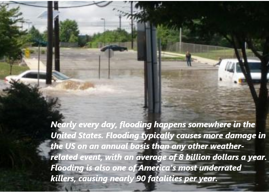
Although abundant snow fell in New Jersey’s Lower Raritan Watershed in January and February, March is still the wettest month. Good preparation and knowing what to do in a flood will increase your safety and chances of survival if it happens in your area. It can also help minimize potential flood damage and accelerate recovery efforts.
Flood Preparedness: Before, During, After a Flood
Turn around, don’t drown!
As little as six inches of moving water can sweep an adult off their feet, and just 12 inches of it can carry a small car. A foot of swiftly moving water can also carry away an SUV or truck. Even if you think you know how deep a particular part of the road is, it is better to avoid driving or walking through it altogether. It’s not just the depth alone, either — there’s also the potential for hazardous debris or downed active power lines in or nearby the water. Especially at night after a significant rainfall or flooding event when your vision is not as strong, play it safe and find an alternate route until the water recedes.
Flooding on Joyce Kilmer Avenue, New Brunswick – 2015
2. Sign up for local news and community alerts
The Weather Channel provides free forecasts, radar, and severe weather alerts on their desktop site. The Emergency Email & Wireless Network and Weather Underground offer free email subscriptions of weather and other alerts. By signing up for push alerts to your cellphone, home phone, or email, you can get up-to-the-minute information about flooding. NOAA Radio also broadcasts weather alerts around the nation, and local meteorologists send out alerts when heavy rains or coastal flooding is possible.
3. Know the risks where you live
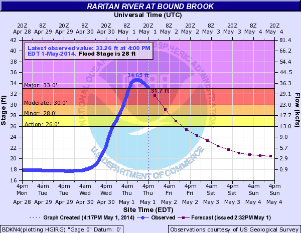
Ask neighbors about flooding risks. Visit your local library to find hyper-local topographical maps of your community, or use the USGS TopoView Viewer tool to get an idea of where nearby water bodies are so you can estimate your chance of being directly affected by flooding. Check your flood insurance policy to ensure appropriate coverage. The LRWP relies on the USGS flood gauge at Bound Brook to give us a sense for local conditions.
You can also take a page from the LRWP’s book of landscape decoding and #lookfortheriver by observing water flows, tracing land contours, and re-discover our buried streams using historic maps.
4. Prepare a “go kit” for flood season and other emergencies
Do you have an evacuation plan in place for your family and pets in cases of fire or other threats? Does it include a “go kit”? A “go kit” is a great way to always stay prepared. Some items you can keep in this waterproof kit are:
Non-perishable food
Water bottles
Sleeping bag and blankets for each person
A full change of clothes for each person, and an extra set of masks
Important documents sealed in a waterproof case
Cash or traveler’s checks
Pet food
Baby formula
A 30-day supply of any necessary medications
You can find a full list of items that are good to have at the ready year-round here.
The actions listed above are just some of many actions each of us can take to prevent loss of lives, jobs and homes in the face of flooding. We also must start “thinking regionally” about preparedness, which will help us all be more resilient in a climate uncertain future.
COVID-19 showed what can happen when our states and nation is under-prepared for a pandemic. The recent storms in Texas give us insights into how we can prepare for future weather related crises. Regions that are not prepared for climate change will suffer lost lives, jobs, and homes. This is especially a concern for coastal communities, including many in our Lower Raritan Watershed.
For example, we do not yet have a true flood risk assessment for the Lower Raritan. FEMA flood maps are incomplete, and often inaccurate. And many homes in Lower Raritan communities like South River, Sayreville and Woodbridge are excluded from flood plains for political reasons. Not surprisingly, the maps and processes that communicate risks associated with flooding are often highly politicized. The risk maps often reflect the politics of property developers in flood plains, pressures to keep property values high, and fears of the overwhelming cost of adapting at-risk homes to rising seas and flooding, more than the actual risk.
As part of #ResilientNJ, the LRWP and regional partners are working to conduct an accurate regional risk assessment to understand the magnitude of flood risks and threats for our area. From there we aim to make plans to protect lives, homes and employment that may be vulnerable to flooding, and likewise seek to identify ways to adapt to and mitigate climate change impacts. In coming months the LRWP and County and municipal partners will launch a website, outreach campaign, app and more to engage the larger Middlesex/Lower Raritan community in regional resilience planning. We look forward to working with you!
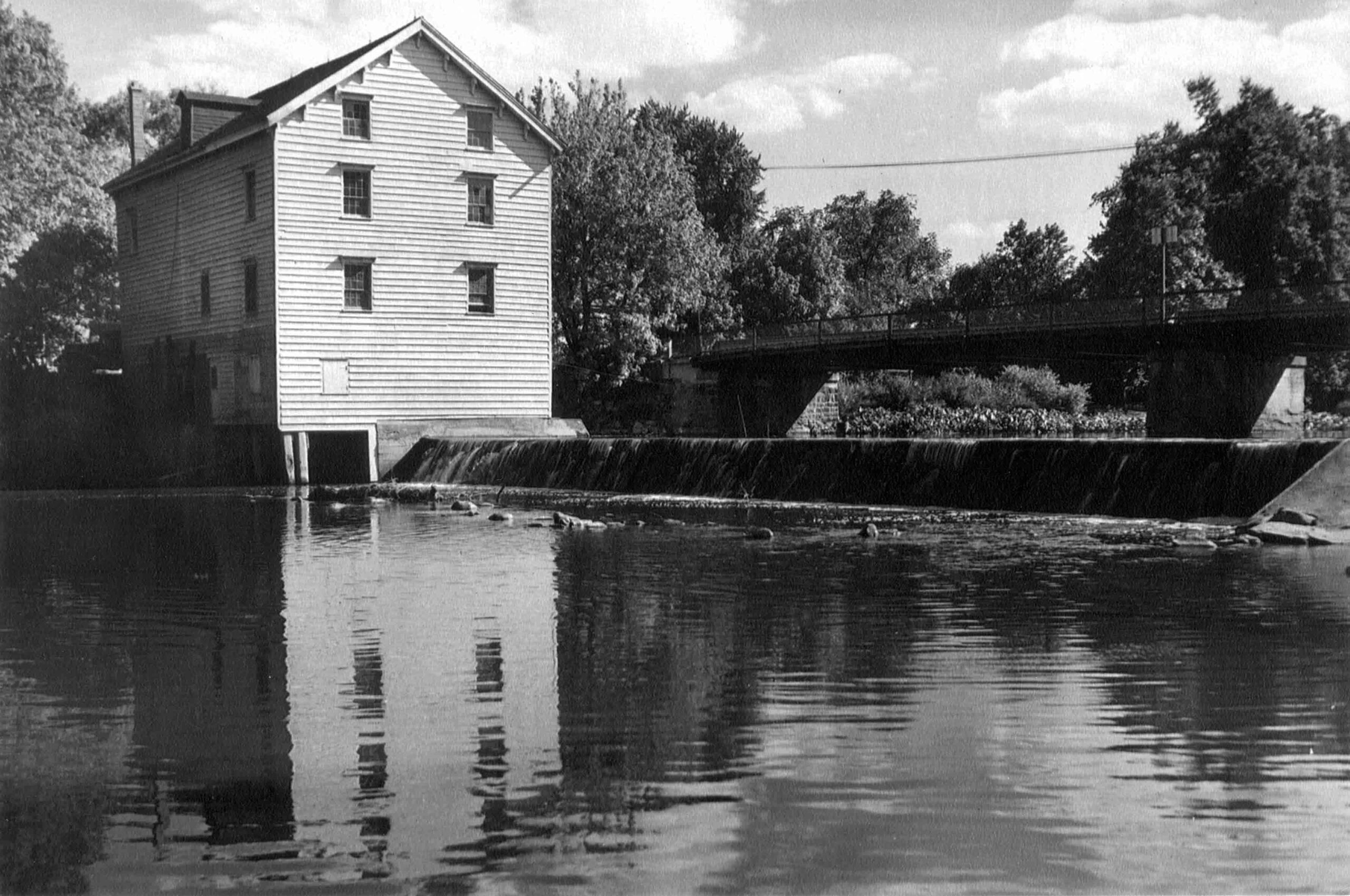
The Weston Mill Dam and the former Weston Mill gristmill and sawmill site are located approximately 1.5 miles upstream of the Millstone River’s confluence with the Raritan River, and immediately downstream of the Weston Causeway (Wilhousky Street) Bridge in the Borough of Manville and the Township of Franklin, Somerset County, New Jersey. The dam crest length was approximately 112.5 feet long and there was a concrete approach apron that ranged in thickness from 5 to 6.75-inches that extended 17.5 to 18.5 feet upriver of the dam spillway. The location of the mill was depicted on early Colonial-era and Revolutionary War military field maps, and the mill and dam were picturesque landmarks that were often photographed by local residents, including images included in the book Franklin Township [NJ] – Images of America, published in 1997.
Weston Mill Post-1948 to Early 1960s, Photographer Unknown
Through an intensive deed search, I determined that a gristmill and dam were established on the east bank of the Millstone River at the project area circa 1747, most probably built by Abraham Brokaw, and the mill was subsequently involved in a Revolutionary “Forage War” skirmish between British and American forces on January 20, 1777 while under the ownership of Abraham Van Nest. Recovery of two cornerstones during 1983 salvage operations suggest major mill building and rebuilding efforts occurred in 1803 and 1844 by John M. Bayard and Isaac R. Cornell, respectively. Though the mill remained active at this site into the early twentieth century (it was the most productive mill in the Millstone River/Stony Brook drainage), under various private owners and incorporations (Weston Mill Company, Inc.; Community Flour Mill and Grain Company; Union Mills Company, Inc.), and the dam underwent significant structural repairs between circa 1922 and circa 1948 by its last owner (Wilbur Smith), it ultimately fell into disuse and disrepair. On May 31, 1982, the mill building partially collapsed into the Millstone River. Mill artifact salvage operations were initiated on June 25, 1983 but were abandoned when arson claimed the collapsed structure on July 7, 1983.
Weston Mill Dam Initial Breach, Photo: Charles Kahler, PE
Weston Mill Initial Breach, Photo: John W. Jengo, PG
When I first began assessing this dam in 2009 as a candidate for removal, the Weston Mill site included the brownstone and concrete foundation remains of a gristmill that had enclosed a turbine room (formerly the water wheel pit) and a tailrace room, and there were associated powertrain components scattered throughout the site, including multiple bevel gears, possible mortise and pin gears, sprocket gears, drive shafts, counter shafts, flat belt pulleys, and other mill-related power-train apparatuses. A concrete coring project conducted in August 2015 at five representative locations on the dam approach apron (the same effort that determined the thickness of the apron) revealed two concrete approach aprons, which suggested that the dam was reinforced or rebuilt with concrete in two different periods in the early- to mid-twentieth century and that this run-of-the-river dam may have been built on top of a timber crib dam of unknown age.
Routine visits to the dam site over the next eight years would indicate that beginning in 2015, the eastern 78 feet of the dam crest (i.e., the top of the spillway) and spillway began to noticeably subside and detach from the concrete approach apron, placing undue stress on the riverward mill foundation wall to the east. By mid-2017, the collapsing dam crest and spillway had subsided almost to the level of the downstream pool elevation, had deflected outward some five feet downriver, and in doing so, the flow of the river was redirected toward the mill ruins on the east bank, potentially causing adverse effects to the mill foundation and complicating the dam removal.
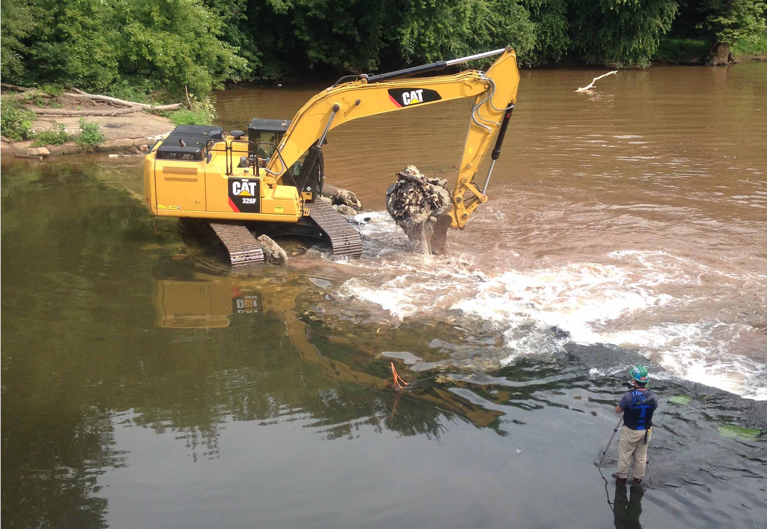
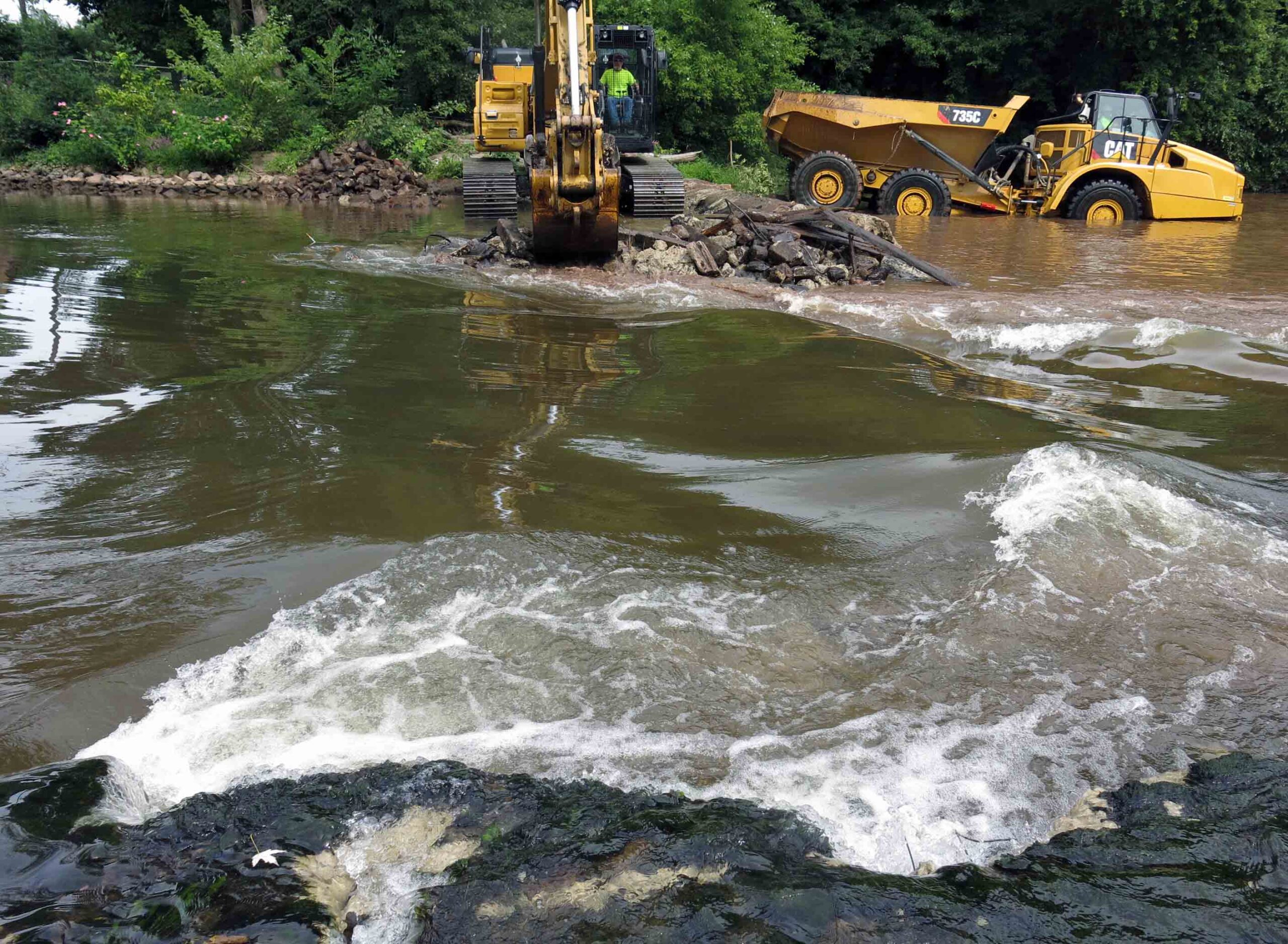
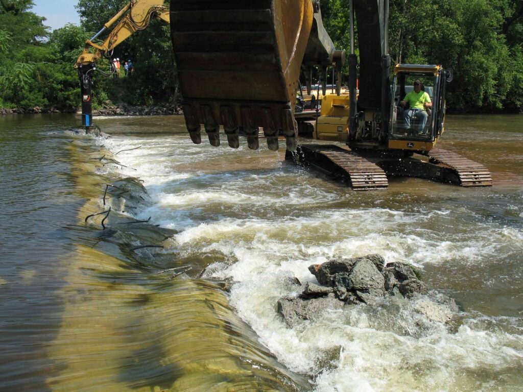
The dam removal and the engineering plans were re-designed to include emplacing scour protection around the Weston Mill foundation walls to arrest the damage to the ruins and preserve the remaining fabric of the site for future study. The first step in the dam removal process, which commenced on August 14, 2017, was to initially breach a portion of the dam to reduce the differential head between the upstream and downstream pools. The initial breach width of 35 feet, located near the center point of the dam, produced the desired upstream pool drawdown and a relatively low current velocity through the breach. Once the upstream impoundment had drained, the contact between the concrete approach apron and the riverward mill foundation wall was accessible to be saw cut to isolate the apron from the mill wall prior to further demolition. This was done to ensure that neither the weight of the demolition excavator or the vibration of the hydraulic hammer would destabilize the riverward foundation wall.
Weston Mill Dam Spillway Removal, Photo: John W. Jengo, PG
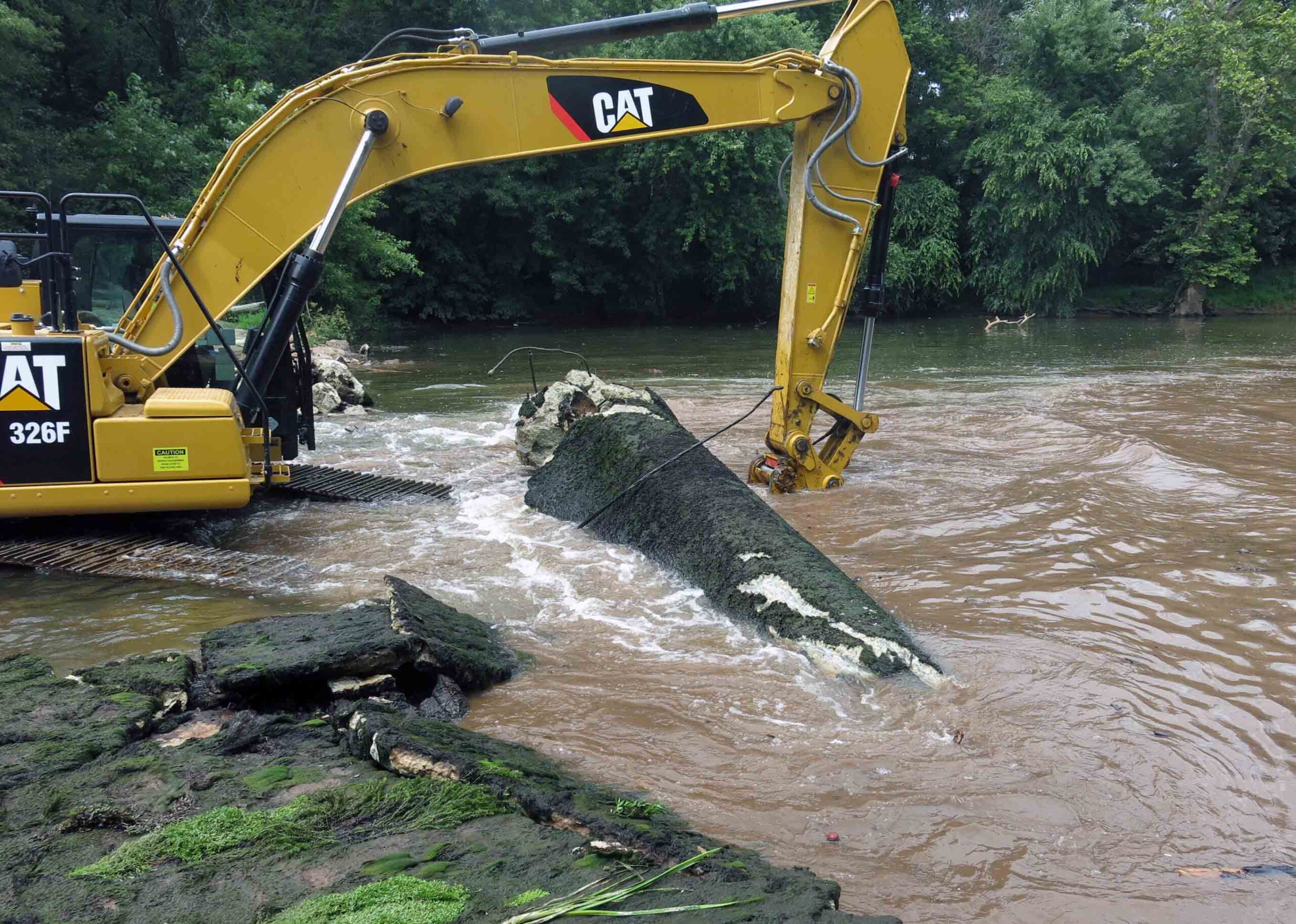
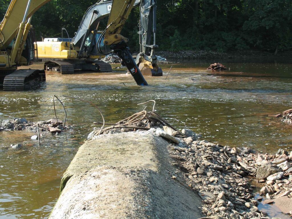
After the saw cut was completed, the concrete approach apron, an underlying concrete sub-apron, and dam spillway were carefully detached and removed. Imported rip rap was then emplaced around the mill foundation walls. My experience working on the rivers of this watershed indicated that natural sedimentation from storm events would eventually blanket and in-fill the rip rap, enhancing the stability of the scour protection armament. Finally, a restored river channel thalweg were excavated and contoured appropriately. It was during these excavations that segments of a timber crib dam, secured to the river bed by using 17.5-inch to 20.5-inch long, 1.125-inch square iron spikes, were extracted that clearly indicated that the pre-concrete dam structure was a timber crib construction. Three primary types of roughly square timbers believed to be part of the timber crib dam were identified: 13-foot long lap jointed foundation logs with iron spikes, 9.25- to 9.75-foot timbers with two mortise joints (some with intact dowels), and 3.8-foot timbers with tenons at one end. Several timbers of this historical structure were saved and donated to the Borough of Manville, Delaware and Raritan Canal State Park, and NJDEP, who had purchased the dam site in 2013 from a private owner, an acquisition that allowed the dam removal to proceed.
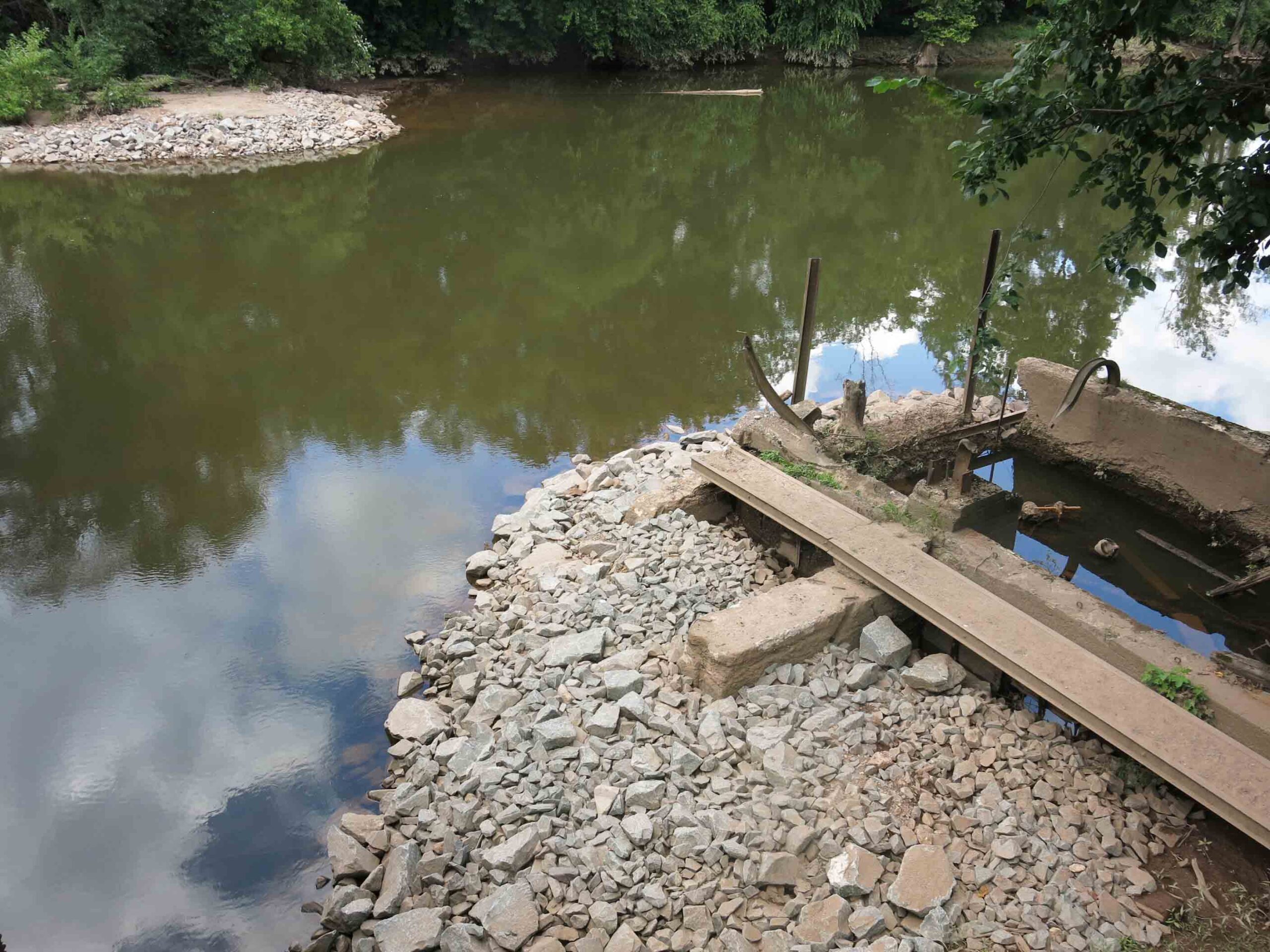
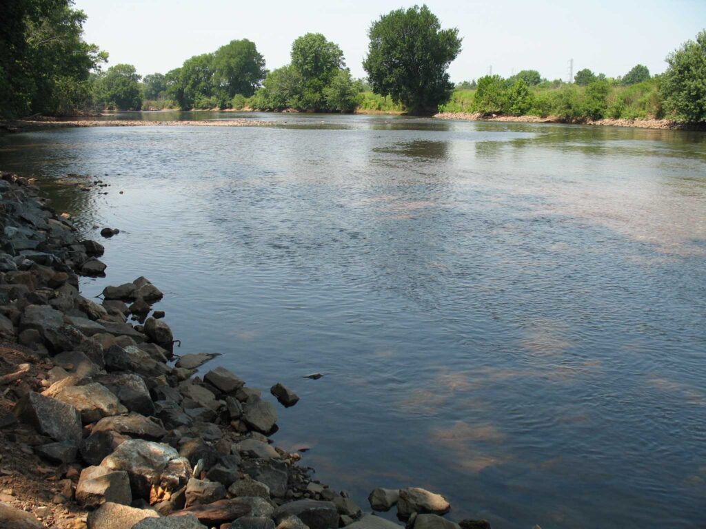
Weston Mill Dam Post Removal, Photo: John W. Jengo, PG
Monitoring of the river reach above the former Weston Mill Dam in spring 2018 following the August 2017 dam removal found definitive evidence of successful American shad spawning, an astonishing and long-awaited result given this river reach had effectively been blocked to migratory fish for over 270 years. Five juvenile shad averaging 4.3 inches in length were found 4.5 miles upstream of the dam at the base of Blackwells Mills Dam during a monitoring visit, highlighting yet again the dam removals can yield near-instantaneous positive results even after centuries of impeding fish migration and spawning.
Video of the Weston Mill Dam removal can be viewed here:
Endnote: Because of the archaeological discoveries made before and during the dam removal, and the rich cultural history of Weston Mill, a standalone video on the History of Weston Mill was developed and can be viewed here:
John W. Jengo, PG, LSRP is a licensed Professional Geologist in several Northeastern and Southeastern states and a Licensed Site Remediation Professional in New Jersey. John works as a Principal Hydrogeologist in an environmental consulting firm in southeastern Pennsylvania. He has degrees in geology from Rutgers University (1980) and the University of Delaware (1982). Over the last 30 years, he has conducted the characterization and remediation of large, complex contaminated industrial sites throughout New Jersey, Pennsylvania, and Delaware. He played a key role in Natural Resource Damage (NRD) assessments that led to groundbreaking legal settlements to remove numerous low head dams on the Raritan and Millstone Rivers to restore historically significant migratory fish spawning runs. As technical project manager, he planned, permitted, and successfully managed the removal of the Calco Dam, the Robert Street Dam, and the Nevius Street Dam between 2008-2013, and the removal of the Weston Mill Dam on the Millstone River in 2017, along with leading the archaeological investigation of the former Weston Mill in the Borough of Manville and Franklin Township.
Calco Dam, positioned at Raritan River Mile (RM) 20.9, was located in Bridgewater and Franklin Townships, Somerset County, New Jersey just upriver from the Borough of Bound Brook. Calco Dam, technically a low-head loss dispersant weir, was constructed in 1938 by the Calco Chemical Company, Inc. as part of the effluent conveyance system for a synthetic dyestuff manufacturing operation that had been established at this location in 1915. To direct effluent flow to Calco Dam, a diversion structure was built on a natural stream (Cuckels Brook) 800 feet north of the dam, and as part of the diversion construction, a canal was dug from that structure to Calco Dam; a screening structure was installed at the end of the canal to prevent debris from flowing into the dispersant pipe inside the dam. The center dispersant weir section of Calco Dam was 123 feet long and was composed of a 36-inch-diameter effluent tile pipe encased in concrete, which had on its downstream side a total of 41 8-inch-diameter outlets spaced three feet apart. The weir structure was connected to the river banks by approximately 50- to 55-foot-long solid concrete abutments, making Calco Dam a run-of-the-river structure. According to the original design drawings, Calco Dam varied in width between 21.25-23 feet and it had a structural height of approximately seven feet. There was an 18-inch-thick, 12-foot-wide concrete apron extending downstream from the dam crest, ending in an apron toe section extending 3 feet below the river bed.
Calco Dam Before Removal
When the Somerset Raritan Valley Sewerage Authority (SRVSA) purchased the manufacturing site’s wastewater treatment plant operations in 1985, ownership of Calco Dam also transferred to SRVSA because the dam was an integral part of the facility wastewater effluent discharge system. Although SRVSA was utilizing Calco Dam for discharging treated municipal effluent into the Raritan River when I approached them in 2008 about removing the dam, they were already in the process of designing and permitting an alternative effluent discharge route and outfall to the Raritan River, which would allow Calco Dam to be abandoned and removed. SRVSA immediately recognized the value of eliminating the potential liability of a dam and they became the model of a cooperative dam owner in the subsequent contractual negotiations to grant us permission to remove Calco Dam.
The Calco Dam removal was successfully accomplished between July 18 and August 1, 2011, but the removal had an unique engineering component. In planning the dam removal, I ascertained that the southernmost end of the dam had been incorporated into and under the towpath berm of the historic Delaware and Raritan (D&R) Canal, although a fair portion of this dam section had been subsequently exposed by scour eddies caused by water flowing over the dam. The effect of any further excavation on the stability of the D&R Canal towpath berm was considered too risky to implement so a decision was to made to leave that southernmost section of the dam intact and rebury the section that had become exposed from the river’s scouring action. To isolate this dam section from the remainder of the structure that was to be removed required that a methodology be devised to cut through the entire dam structure with a minimal amount of disturbance to the towpath berm (the dam was much too thick to be saw cut). Taking advantage of the same scour pool that had dangerously eroded into the base of the towpath berm, we built a temporary coffer dam around this section of the dam, dewatered it, and proceeded to drill and extract dozens of overlapping 6.5-inch diameter concrete cores across the width of the dam in the process known as “stitch coring.” Once the isolation of this section of the dam was completed, we imported tons of properly-sized rock riprap and rebuilt the base of the D&R Canal towpath berm back into its original configuration with the southernmost dam fragment now serving as a stable foundation for the reconstruction. Success of this restoration was tested just a few weeks later during back-to-back record flooding events from Hurricane Irene and Tropical Storm Lee when this section of the repaired D&R Canal towpath berm held firm while other sections along the D&R Canal route suffered washouts and breaches.
Calco Dam During Initial BreachingCalco Dam During Final BreachingCalco Dam Stitch Coring
The number of returning migratory fish in the Raritan River the following spring heralded the remarkable and rapid recovery of the Raritan River at the Calco Dam location. Based on observations at the upstream Island Farm Weir (IFW) fish ladder viewing window in the first spring migration season (March-May 2012) following the dam removal, the number of American shad migrating upstream increased 500% and the total number of fish passing through the IFW fish ladder increased by 200%. This essentially instantaneous result propelled the planning of the next two dam removals, which were accomplished in just the next two years (Robert Street Dam in 2012 and the Nevius Street Dam in 2013), and this succession of three dam removals in just three years is considered to be one of the most ambitious river restoration efforts that have implemented to date.
Calco Dam After Removal
John W. Jengo, PG, LSRP is a licensed Professional Geologist in several Northeastern and Southeastern states and a Licensed Site Remediation Professional in New Jersey. John works as a Principal Hydrogeologist in an environmental consulting firm in southeastern Pennsylvania. He has degrees in geology from Rutgers University (1980) and the University of Delaware (1982). Over the last 30 years, he has conducted the characterization and remediation of large, complex contaminated industrial sites throughout New Jersey, Pennsylvania, and Delaware. He played a key role in Natural Resource Damage (NRD) assessments that led to groundbreaking legal settlements to remove numerous low head dams on the Raritan and Millstone Rivers to restore historically significant migratory fish spawning runs. As technical project manager, he planned, permitted, and successfully managed the removal of the Calco Dam, the Robert Street Dam, and the Nevius Street Dam between 2008-2013, and the removal of the Weston Mill Dam on the Millstone River in 2017, along with leading the archaeological investigation of the former Weston Mill in the Borough of Manville and Franklin Township.
Article by Angely Melendez, written as part of the Rutgers Spring Semester 2020 Environmental Communications course
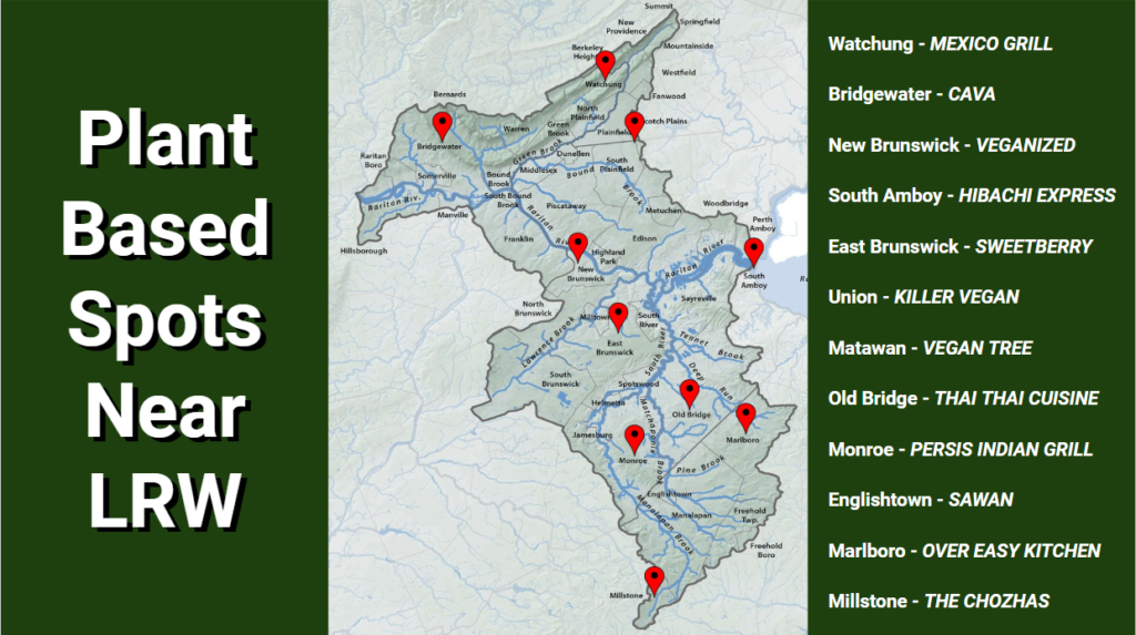
November 1, 2020 is World Vegan Day. Want to celebrate? See below for a listing of the many vegan and vegetarian restaurants in the Lower Raritan Watershed to choose from!
Plant Based Restaurants in the Lower Raritan Watershed
Ask someone just 20 years ago if they’d go vegetarian or vegan and they’d say no, you’re crazy. Meat has always been a staple within American cuisine and continues to be so, but even in the last 3 years there has been a 600% increase in Americans who consider themselves vegan. A staggering percentage, to say the least, but although those numbers are great, that’s still only 6% of American consumers in 2017 (“Veganism is at an All-Time High: Is it A Fleeting Fad or The New Norm?” 2018).
For the meat eaters out there that are still unsure of what the excitement is all about, I want to introduce World Vegan Day. This day visits us every November 1, and introduces the idea of the ever so popular diets: vegetarianism and veganism. Maybe the possibility of seeing what the hub-bub is all about intrigues you, and if that’s the case, then this is the day for you. See the map above for a route around the Lower Raritan River with stops all along it at plant based restaurants or others that feature plant based options.
So, what can these diets offer you? A slew of things, actually. One of the big factors to go plant-based is due to health. According to Harvard Medical School, a vegetarian diet offers some wonderful benefits and takes out some of the harmful negatives, “… As a result, [making them] likely to have lower total and LDL (bad) cholesterol, lower blood pressure, and lower body mass index (BMI), all of which are associated with longevity and a reduced risk for many chronic diseases.”
Besides personal gains, you’d also be doing the Earth (and our Lower Raritan Watershed) a huge solid. A big sign of inefficiency within agriculture lies within the raising of animals for their meat. About 70% of grain and cereals grown in the U.S. are fed to farm animals. Keeping that in mind, 16lbs of grain goes into producing 1lb of meat. And since demand for meat is so high, these farms continue to expand, knocking down natural ecosystems for the production of corn. Instead of using all those resources and high amounts of energy to produce that little amount of consumable meat, it could instead be used for humans.
So, come out to the Lower Raritan River during World Vegan Day, check out what local vegan and vegetarian restaurants have on offer, and learn why the grass is greener on the other side!
Effective communication about the environment is critical to raising awareness and influencing the public’s response and concern about the environment. The course Environmental Communication (11:374:325), taught by Dr. Mary Nucci of the Department of Human Ecology at Rutgers University, focuses on improving student’s writing and speaking skills while introducing students to using communication as a tool for environmental change. Students not only spend time in class being exposed to content about environmental communication, but also meet with communicators from a range of local environmental organizations to understand the issues they face in communicating about the environment. In 2019 and 2020, the course applied their knowledge to creating blogs for their “client,” the Lower Raritan Watershed Partnership (LRWP). Under the guidance of LRWP Founder, Dr. Heather Fenyk, students in the course researched topics about water quality and recreation along the Raritan. Throughout 2020 the LRWP will share student work on our website.
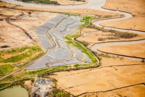
One of many Raritan River-adjacent landfills/Superfund sites at-risk of flood impacts Photo by Alison M. Jones, No Water No Life – taken during a LightHawk flight, April 2019
On Tuesday May 12, 5:30-6:30 pm join Heather Fenyk with the Lower Raritan Watershed Partnership, Alison M. Jones with No Water No Life, and Joe Mish (aka Winter Bear Rising) author of the LRWP series “Nature on the Raritan, Hidden in Plain View” for a virtual tour of the Raritan Basin.
During this hour long tour Heather, Alison and Joe will share and discuss images taken during a LightHawk flight on April 2019. With many thanks to LightHawk, Inc. for the experience – we look forward to sharing some the experience with you.
This was a very special flight. We expect it to be a very special conversation.
The Watershed Illustration Curriculum was developed to raise awareness about the endangered species of New Jersey, especially the flora and fauna of the Lower Raritan Watershed. Every species in the curriculum, from the Bald Eagle to the Closed Bottled Gentian, is in immediate danger due to human activities. These human activities are responsible for loss of species habitat due to habitat fragmentation and deforestation, over-exploitation of resources, disturbances, disease, introduction of invasive species, pollution and climate change. The survival of every species of wildlife is critical to preserving our state’s rich biodiversity and unique natural history.Unlike other natural threats, man-made threats are threats that we can prevent by changing our behavior.
These curriculum guides combine art and science to help students develop their creativity and artistic skills, while advancing their knowledge of the endangered species and plants that are in close proximity to them. By focusing on art, we also try to make the connection to the environment a personal experience. To save wildlife requires positive action. It requires changes in lifestyle and way of thinking.
As humans, we have the ability to understand the consequences of our actions, both present and past. We are capable of learning more about the effects our actions have on the world around us and how changes in those actions could help to alter future events. By examining how human activities have adversely impacted life on earth, we can take steps to reverse past damages and prevent future damage.
Thank you for learning about the special wildlife in the Lower Raritan, and how you can help protect them!
“I have two doctors, my left leg and my right.”-G.M. Trevelyan
The silver lining in COVID-19-related time off from work and school? More hours to get outside.
Time out-of-doors yields illness-fighting benefits (a few are listed below). Check out the Lower Raritan Watershed Partnership’s map of open space in the Lower Raritan or find a park map for your area, lace up your shoes, and head outdoors. Getting outside may be just what the doctor ordered.
1. Breathe fresh air. Although the viruses that cause flu and colds are more common in the winter months, the circulated air in closed environments is the main cause of illness. Windows are closed, germs are recycled through air vents, and the general tendency in cooler months is to stay indoors. The thing is, the more time spent inside, the more you risk exposure. In fresh outdoor air the chance for spreading infection is reduced.
2. Strengthen the immune system. Time outside gives you an escape from indoor germs and bacteria. Increased time outside is associated with stronger autoimmune systems, and a resistance to allergies. Studies have shown that children in rural areas, or who are active outside, have the best overall health.
3. Engage in physical exercise. Time outside is associated with greater physical activity, and physical activity gives your immune system a power surge for a full 24 hours. A stronger immune system leads to less illness and less use of antibiotics.
4. Shift your perspective. Time outside can be a welcome break from the technology-focus of our 21st century lives. Get out for a wildlife hike and watch the birds and other critters – many of them are in full throttle nest building this time of the year. Taking a break out-of-doors, connecting with local ecology, is great for your mental health!