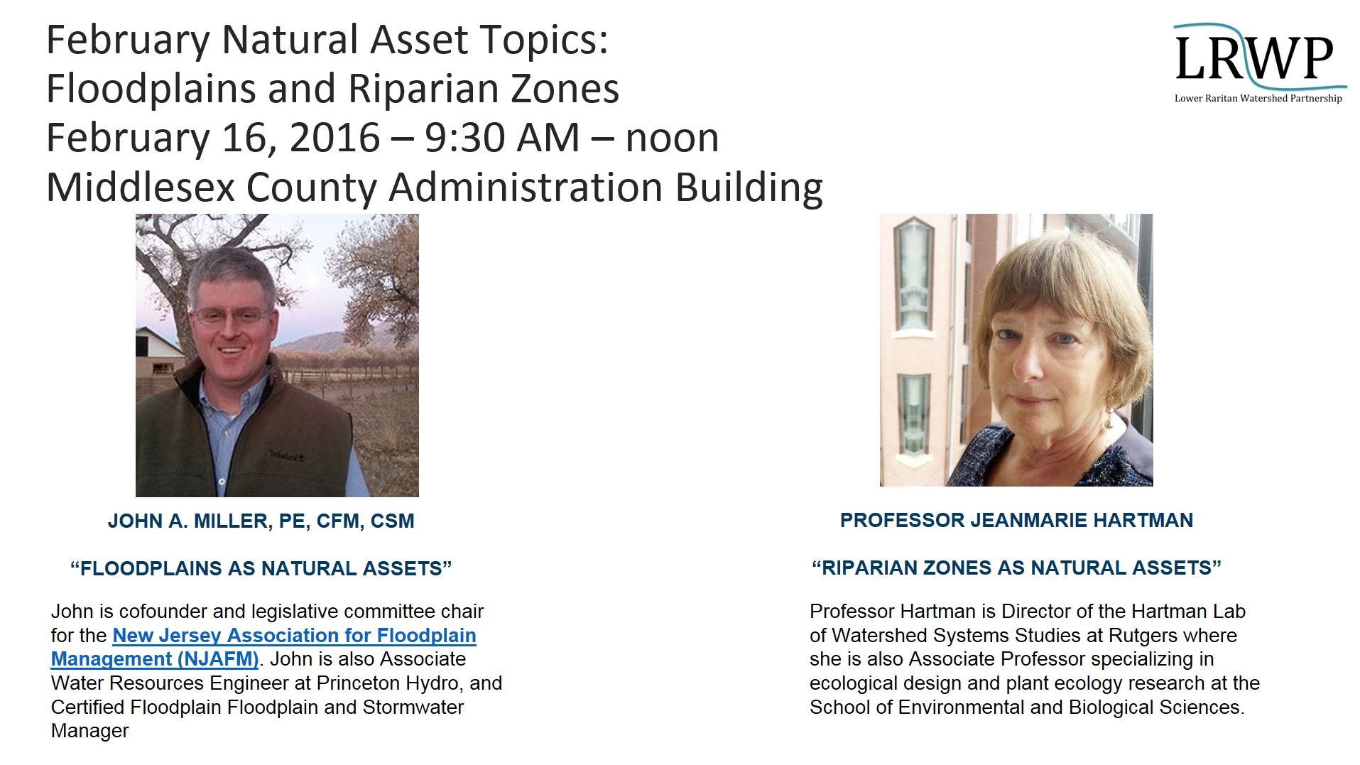
Join the LRWP from 9-noon on February 16th when we will hear presentations on Natural Resource Assets by John A, Miller, Princeton Hydro Water Resources Engineer and co-founder and legislative committee chair for the New Jersey Association for Floodplain Management and Rutgers Professor JeanMarie Hartman, Director of the Hartman Lab of Watershed Systems Studies at Rutgers.
Natural Assets Map Project Background
In February 2015 at a workshop on Impervious Cover Remediation (ICR) co-hosted by the LRWP and Rutgers Cooperative Extension Water Resources, the LRWP recognized a need for tools to help communities implement Green Infrastructure (GI) and meet ICR goals. At the ICR workshop municipal representatives expressed an interest in minimizing stormwater runoff, with many of of these reps suggesting that their communities set impervious cover reduction targets. But where to start? How could towns best prioritize resources for ICR and GI implementation?
To help LRW communities on this path the LRWP researched tools that would help with strategic location of ICR and GI sites. We found references to a process called “Natural Assets Mapping” that suggests not only a prioritization process, but also provides an approach to orienting community conversations around valuation of ecosystem services and the benefits supplied to human societies by natural ecosystems.
Working with input from the Middlesex County Department of Planning we shaped a speaker series for 2016 to guide development of a Natural Assets Map for the Lower Raritan Watershed (Watershed Management Area 9), and to prime municipal conversations regarding prioritization of GI and ICR.
Our goals for the project include:
To evaluate, prioritize and map natural and cultural assets in the Lower Raritan Watershed.
2. To support community stewardship of Green Infrastructure (GI) / Nature-Based Solutions, including:
-Informing development of GI Master Plans
-Identifying opportunities to add GI to capital projects
-Helping communities link to GI performance rates
-Helping develop design standards for GI related to identified assets.
3. To identify potential investments to optimize the existing system.
4. To advance and support stormwater management planning at County / municipal levels.
5. To improve administration of environmentalism in the LRW.
The 2016 Natural Assets Mapping kick-off
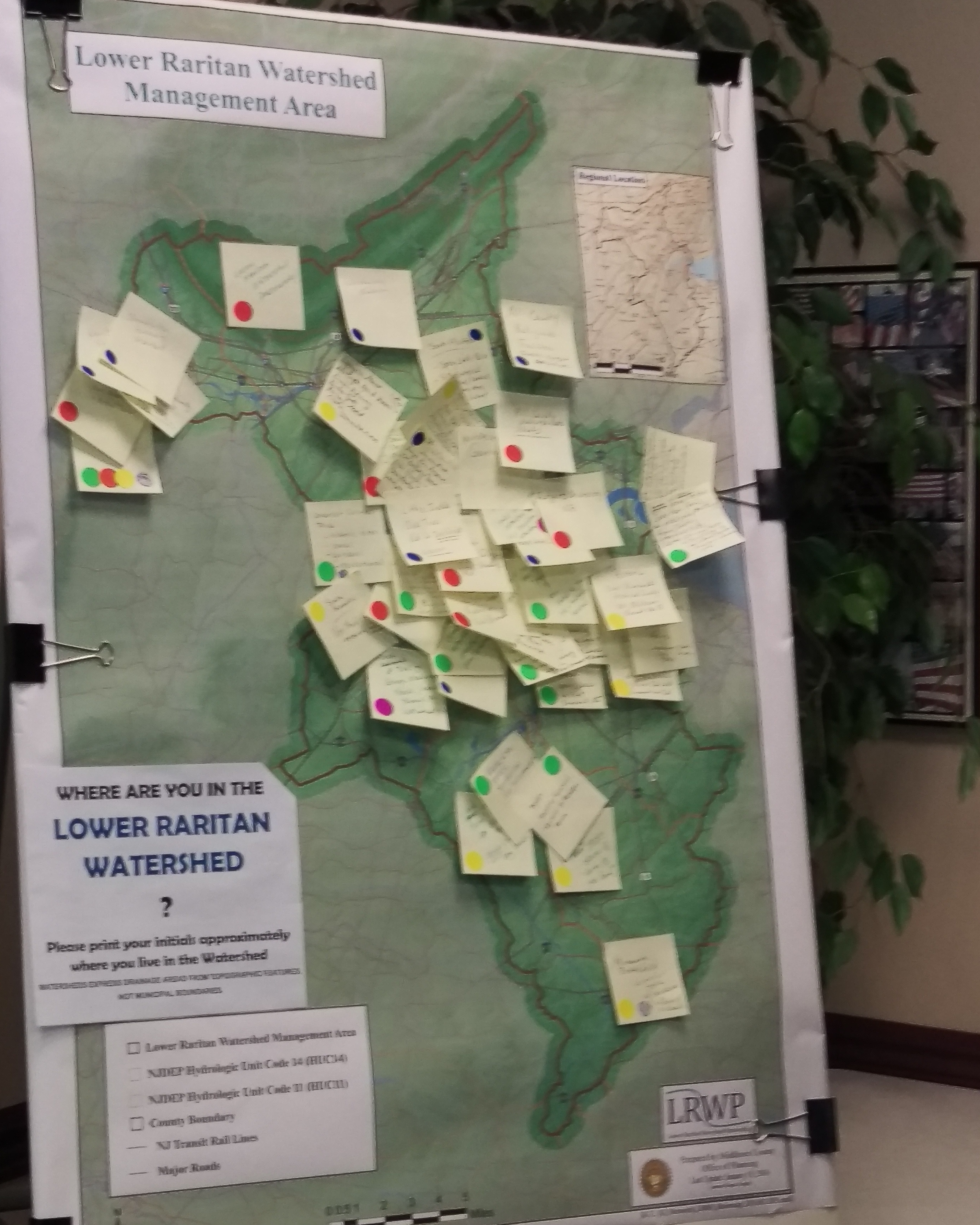
At the 2016 Natural Assets Mapping kick-off event on Tuesday January 26, LRWP Land Use Planner Angela Knowles gave an overview of the Natural Assets Mapping process as outlined by Karen Firehock at the University of Virginia. Angela provided highlights of the document we are using to guide our work (“Evaluating and Conserving Green Infrastructure Across the Landscape: A Practitioner’s Guide“) and described the various GIS layers the LRWP plans to discuss going forward.
Angela also explained how, using these layers, we will map environmental, cultural, historic, and human assets throughout the watershed in an interdisciplinary way. With GIS, LRWP communities will be able to see where particular features are found, what geographical patterns exist, and what changes have occurred over a given time period. We aim to identify the natural assets in the watershed and how they relate to other community assets so that we can conserve, and/or restore the natural features that are most valuable to communities. This further reduces the need to build engineered structures to deal with issues like stormwater runoff in favor of more cost effective, natural solutions.
At the kick-off, attendees brought attention to various environmental, cultural, historic, and human assets that they personally thought were valuable in a group mapping exercise. The LRWP will devote much of the year to reaching out to community members around the LRW to pinpoint certain areas that may be less known to many, but no less valuable.
Speaker themes for 2016 include natural resource assets, cultural and historic assets, transportation and mobility assets, seeing brownfields as community assets for restoration, and economic assets, innovation, & regional planning. We are very excited for the opportunity to have state and regional experts on these topics join us for these presentations, and we hope you will join us as well! Please see our events page for more information.
The LRWP thanks Professor Lathrop, the newly-appointed Johnson Family Chair in Water Resources and Watershed Ecology at Rutgers University, for sharing his vision for how Rutgers can provide academic leadership to improve the health of the Raritan River. For more information about the Johnson Family Chair and Professor Lathrop’s new position please see the Rutgers Today Press Release.
By Richard G. Lathrop Jr.
Modern society is increasingly coming to recognize water as a critical resource, on a par with oil and gas. Water scarcity, whether due to prolonged drought, political instability, regional conflict or any combination of the above, is at a crisis stage on the US West Coast, across the Middle East and elsewhere around the globe. Point sources of water contamination or more diffuse sources of pollution related to urban, suburban or agricultural land uses is also of increasing concern. Ensuring access to clean and abundant water to sustain both human society and healthy ecosystems over the 21st century will require a concerted effort on the part of government, academic, private and non-profit sectors. From an academic standpoint, addressing this challenge will require not only an interdisciplinary approach bridging the social, political and natural sciences but also a watershed perspective that links the land surface to downstream aquatic systems. The Johnson Family Chair in Water Resources and Watershed Ecology is intended to undergird such an effort here at Rutgers University.
In the heart of the most densely populated region in the nation, the Raritan River Watershed serves as a “natural laboratory” to study how human actions and policies both negatively and positively affect ecological health of a watershed system. One of my major focal areas as Johnson Family Chair will be co-leading the Sustainable Raritan River Initiative (SRRI). The objective of the SRRI is to work with various stakeholders in the watershed to balance social, economic and environmental objectives towards the common goal of restoring the Raritan River, its tributaries and its estuary for current and future generations. Since the founding of the SRRI in 2009, the Edward J. Bloustein School of Planning and Public Policy has provided academic leadership in the policy realm and the School of Environmental and Biological Sciences in the scientific realm. The SRRI in turn partners with the Sustainable Raritan River Collaborative (SRRC) representing a network of over 130 organizations, governmental entities and businesses in the Raritan River Basin. As Johnson Family Chair, I will provide strong scientific leadership to chart SRRI’s future direction and ensure that issues of critical significance to the Raritan watershed are addressed. In addition to my own research, I will coordinate with various individual scientists, departments and research centers to make sure that Rutgers University’s scientific and technical expertise is brought to bear. Working in concert, we should be able to achieve tangible results towards restoring the Raritan River and Bay to a vibrant and biologically diverse ecosystem for the benefit of present and future citizens of the state and region. Further, the lessons learned from the science and policy research conducted under SRRI’s rubric will transcend the local environs and have relevance elsewhere in the United States, as well as globally.
Within the University, as the Johnson Family Chair I will play a key role in developing and promoting an academic agenda centered on the Raritan River and its watershed. Such an academic agenda will seek to engage a variety of curricula, both on- and off-campus, to make greater use of the Raritan River and the Rutgers Ecological Preserve as part of their educational program. These places provide experiential learning sites where students can observe and collect data as well as get their “hands dirty” by undertaking experimental manipulations and be involved in hands-on restoration and enhancement, design or arts projects. Within the EcoPreserve or on the Raritan, students can put into practice classroom or online learning in a real world environment. These field experiences will be coupled with advanced information technology to integrate field data collection with real-time sensor networks and geospatial information systems to make the EcoPreserve and the River a natural classroom as well as a living laboratory. One great advantage of the EcoPreserve and the River is that they are right on campus and accessible to students via the campus bus system; thus making their use for instructional purposes both time and cost effective. While our alma mater celebrates the University’s location “on the banks of the old Raritan” the University does not have ready access to the river proper. To help rectify this situation, the Chair will spearhead a feasibility study for the development of a Raritan River Watershed teaching/research field facility to be able to bring classes to and out on the water.
The Rutgers New Brunswick-Piscataway campus is blessed to have 400 acres of open space right at its very core, the Rutgers Ecological Preserve and Natural Teaching Area. As Johnson Family Chair, I will serve as Faculty Director of the Ecological Preserve, building on past success to further integrate the EcoPreserve into the life of the University and the surrounding community. As outlined above, the University has the opportunity to build a world-class educational program around the EcoPreserve and lead the United States in the academic pursuit of natural areas/open space stewardship, ecological restoration and leadership training. As the “voice” for the EcoPreserve as the University moves towards implementing the recently announced Physical Master Plan, I will strive to ensure that the role of the EcoPreserve to enhance student instruction and community quality of life is more fully realized.
Personal Background: Richard G. Lathrop Jr.
I have 25+ years of experience working with a diverse array of federal, state, and local government agencies and non-governmental organizations (NGOs) including watershed associations, land trusts, environmental NGOs, federal and state environmental agencies, and regional land/ocean management agencies. My interaction with these various groups has been to integrate insights from ecology and geography with the application of geo-spatial information science and technology to provide a “big picture” view that spans from an individual wetland or forest to the watershed to multi-state regions. More specifically, I have focused on measuring and modeling the how human land use activities and natural habitat change in the watershed affect downstream aquatic and estuarine structure and function. For example, as part of the Barnegat Bay National Estuary Program, I have been investigating the spatial and temporal dynamics of salt marshes and seagrass beds, both key nursery habitats for a number of commercially important fish and shellfish species, as key indicators of estuarine health. Working with the above partners, I have attempted to translate that understanding into effective and appropriate approaches and policies to improve natural resource management and land use planning. For example, in collaboration with the Nature Conservancy and other local partners, we have created the Restoration Explorer, an online tool that provides communities with a simple way to visualize where beneficial coastal restoration and enhancement projects are most appropriate based on ecological and engineering data. In my work, I have on multiple occasions assembled and lead multi-disciplinary teams to address water resources and watershed ecological issues. While much of my work has been conducted using New Jersey and MidAtlantic case studies, the implications of this research are relevant much more broadly, to elsewhere in the United States, as well as globally.
In 2009, Dean Robert Goodman appointed me as Faculty Director of the Rutgers Ecological Preserve with the charge to actively promote its teaching, research, active/passive recreation, and resource protection mission. I sought this position as a means to further my understanding of ‘on-the-ground’ natural resource management by being engaged personally in managing and restoring this 400 acre property, as well as an opportunity to further student engagement in learning and appreciation of the natural environment.
During my tenure:1) use of the Preserve has increased for academic purposes though a range of formal and informal instructional activities engaging middle and high school (including underserved youth), undergraduate, graduate and ROTC students; 2) use has increased for student research projects investigating such topics as the dispersal and control of invasive plants; 3) service learning opportunities have been provided to Rutgers courses (Principles of Natural Resource Management) and clubs (RU Outdoors Club, Naturalist Club) and outside groups (4-H, middle-high school environmental clubs); 4) natural resource values have been promoted though proactive meadow management, deer population control, riparian zone restoration, and wildlife habitat enhancements; 5) a forest vegetation inventory undertaken to provide a baseline on the forest community composition and health; 6) access has been increased by developing an extensive (7.5 miles), well maintained trail system and the opening up a new trailhead on Livingston campus; and 7) outdoor recreational opportunities have been enhanced through organized events that accommodate hundreds of participants (RU Muddy, Run for the Woods, Orienteering meets).
In closing, I grew up in the Raritan River Watershed and have lived 40 of my 56 years here. I hike its woods, paddle its waters and observe its wildlife. Thus I am personally invested in making the Raritan River Watershed a better place to live for its human inhabitants as well as its flora and fauna.
by Maya Fenyk (age 11), LRWP youth consultant and “Endangered & Threatened Species” series contributor
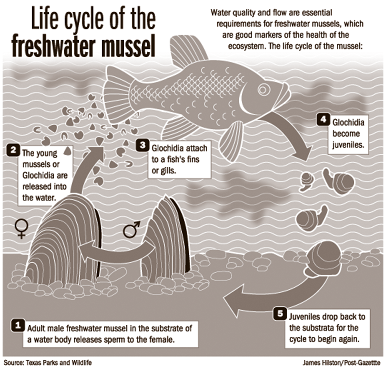
Hello! I’m Maya, a green floater mussel (less commonly known as Lasmigona subviridis). I live in the Lower Raritan Watershed of New Jersey, but my relatives can be found as far south as the Cape Fear River Basin in North Carolina, and as far north as the Lawrence River Basin in New York. I am two years old, no longer a baby glochida relying on a host fish for food and safety. Now that I’m a juvenile I bury under the sediment at the bottom of the Raritan River for protection. My favorite foods are plankton and little bits of plant matter that drift through my filter.
Green Floater Mussel Life Cycle (Image: Texas Parks & Wildlife)
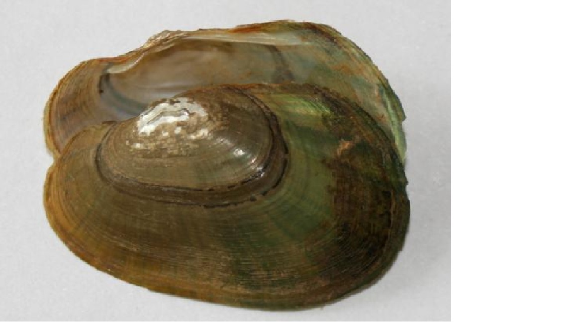
I bet you are wondering what I look like. Well, I have a trapezoid bivalve and my outer shell is yellow and brown with many green streaks. My nacre (the inside, or lining of my shell) is white or blue and iridescent. I am also very small, just a little more than an inch now, but when I’m a grown up I’ll be almost 5 inches! It will take me another four years to get that big, and I can’t wait! Then I will be able to float around the Raritan River looking for food. Some of my relatives have lived until they were 100. If I’m lucky to live that long, I’ll be able to explore a lot of the River in my lifetime!
Green Floater Mussel (Image: New Jersey Conservation Foundation)
Unfortunately, there are a lot of reasons why I might not live to be 3 years old let alone 100. I might be eaten by predators like raccoons, muskrats, bears, otters, heron, waterfowl, turtles or sturgeon. Or my species might go extinct for human-caused reasons. You careless humans are using my home as a trash can, dumping waste right into my river! You have also built a lot of dams, which had led to the removal of some of the host fish our baby glochida rely on to survive until we are juveniles.
Another huge issue is the introduction of foreign species like the Asian clam to our neighborhood. These non-native species compete with us for the same limited food supply and sometimes we don’t get enough to eat. Another problem I’m facing now as a juvenile is the erosion of the sediment on the bottom of the river. This sediment is supposed to be a cozy blanket of protection for me and friends, keeping us hidden from predators as we grow into adults. But erosion makes the silt move, threatening to reveal my hiding place. This erosion happens from things like building and farming, and the use of road salt on the roads in the winter. My corner of the Raritan River also has a history of people dumping not just sewage but toxic industrial waste. Yuck!
Unfortunately, a lot of the river habitat in the United States has been used as a trash can for centuries. Although the 1972 Clean Water Act has made a huge difference in reducing point source pollution, the erosion of sediment in my habitat contimues primarily because of non-point source (NPS) pollution. EVERYONE can do things to help stop NPS, and I would REALLY appreciate your help keeping me safe.
Some of the things you can do to help me survive include:
-Keep debris (litter, pet waste, leaves) out of street gutters and storm drains
-NEVER dispose of used oil, antifreeze, paints or other household chemicals in storm drains or down the sink
-Eat less meat! Animal manure, and the impacts of agriculture (water, fertilizer and pesticide use) associated with animal feed, really does a number on aquatic ecosystems
-Landscape with native plants and plants that have low requirements for water, fertilizers and pesticide
-Leave lawn clippings on your lawn
-Stabilize erosion-prone areas
-Use less water when showering, washing dishes or clothes, or brushing your teeth
-Drive less! Automobiles release a lot of pollution, which increases acid rain that ends up in my River
-Clean up after your pets!
Nice talking to you, but I have to hide quick! I just spotted a hungry sturgeon heading my way!
If you want to know more about me and how to protect my habitat check out this video by Maya and Heather with the Lower Raritan Watershed Partnership:
Click here to read more from the “Voices in the Watershed blog” series.
As I hiked through Jamesburg Park, Jimmy Talnagi stood outside his cabin, lighted punk in hand.
Strange, I thought, I just had an online discussion with fellow, local baby-boomers about punks, or cat-tails. As children, we would light the cigar-like flower, ostensibly to keep mosquitoes away, but more likely to be one of the kids. Jimmy was not part of the recent discussion, but here he was, as if waiting for me, with the smoking punk. And, this being November, was not part of the season for mosquitoes.
I had three punks left from the warmer weather, what am I going to do? Jimmy said. They just start shredding, like a big puff ball.
True, the fluffy vegetation of this punk was coming apart, sticking to my sweatshirt. So, either light them for the heck of it or let them disintegrate.
Jimmy and the punk were one of various unexpected discoveries on today’s walk – a walk on the edge of the woods. The walk was meant to combine two things: one, a hike into nature, and, two, a pragmatic commute to the other side of the woods to Krygier’s Nursery, whose owner, Jimmy Krygier, was giving me a ride to pick up my Jeep, which was getting some mechanical work done about 8 miles away near Englishtown. Because I was tired and busy with house projects, I did not really have the will or the time to get into the woods. So, I compromised, turning down Jimmy picking me up at home, but sort of walking the woods – that is, walking on the edge of the woods – to Jimmy’s house.
So, around 2 p.m. on this overcast day of 55 to 60 degrees that was calm to having a light breeze, I set off toward Cranberry Bog. The idea was to walk the Pipeline to the ConRail railroad tracks, then to the bog, past Shekiro’s Pond into Jamesburg Park and out the woods at Jimmy’s, roughly a walk of two miles.
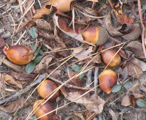
Walking the edge of the woods is not as good as walking deeply into the woods, but I made my first discovery hardly off the beaten track. On the natural gas Pipeline, I came across plentiful and huge acorns. This year is a “mast year,” somewhat of a mystery when oaks really kick out acorns. An oak in my yard was covered with acorns; Here, they were huge.
Huge and plentiful acorns during this “mast year” Here, on the Pipeline.
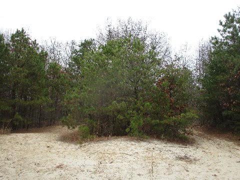
Classic Pine Barrens ecosystem of white sand, pitch pine, Virginia pine, and oak.
Continuing on, I turned toward Helmetta, briefly walking the ConRail freight tracks, before turning toward the Bog. Almost immediately I came across a microcosm of the Pine Barrens: white, beach sand-like soil mixed with oak, pitch pine and Virginia pine. If someone doubts this area is part of the Pine Barrens, have that person look at this scene.
As I continued, I came across blazing red tree leaves, the changing colors of vegetation during the transition from hot to cold weather. What a beautiful scene, but nearby there was evidence a local neighborhood is dumping its vegetative waste in the area. At the Bog, too, I was greeted by another sad scene: invasive phragmites. Not only overtaking the bog as a whole, but overtaking a nice stand of valuable punks.
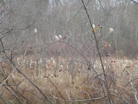
As I moved on, the phragmites invasion continued. I counted five plants growing in Shekiro’s Pond. Five now, but how many in a short time? On the bright side, literally across the unpaved road from the pond, I found nice stands of winterberry. Not only beautiful, but food for birds and decorative material for my Christmas decorations.
Five shoots of very invasive phragmites, with the tassel at top, begins an invasion at Shekiro’s Pond.
I dipped back into civilization at the former worker houses of the George W. Helme Snuff Mill, then worked my way out again into the woods passing Jimmy’s cabin and a few other homes. Finally, I was back in the woods, but out all too soon, my walk done.
Sometime, life gets in the way of doing fun things, such as playing in the woods. So, one has to take advantage of snippets here and there.
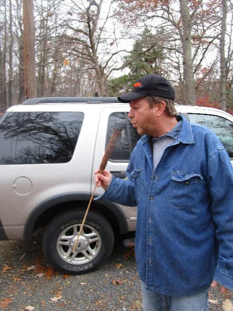
As for the lighted punk, Jimmy insisted I take it as I continued hiking. But it was dry and leaves heavily littered the woods.
I don’t want to set the woods on fire, I said.
This went back and forth, with me finally agreeing. I took the punk, bit into its stem, and held it like a cockeyed version of President Franklin D. Roosevelt and his cigarette.
I tromped on, looking like a swamps-around-Helmetta aristocrat.
Jimmy Talnagi with a lighted punk
Joe Sapia, 59-years-old, grew up in and lives in the Pine Barrens around Helmetta, where his family has resided for more than 100 years. He can be reached at Snufftin AT aol.com or at P.O. Box 275, Helmetta, 08828.