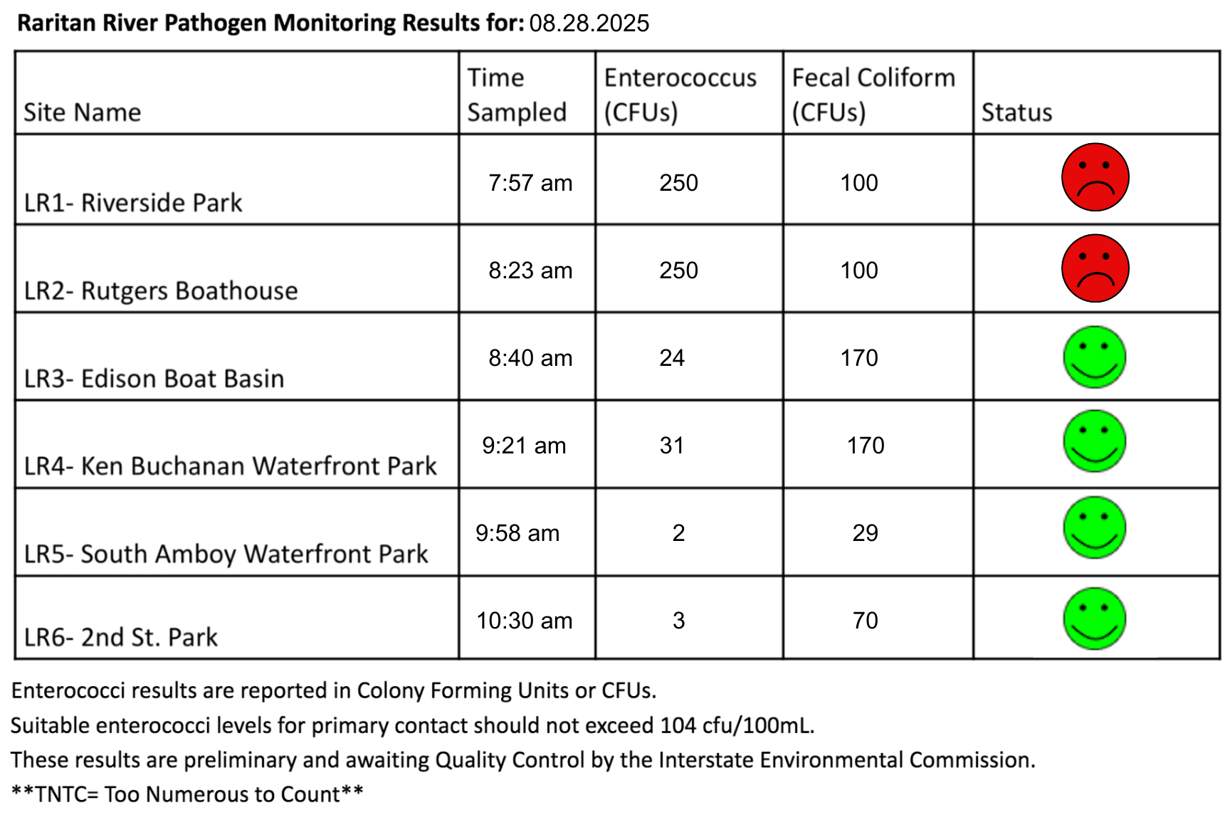
The last pathogen monitoring session of the month took place on Thursday, August 28th. Each week during the summer, from May to October, the Lower Raritan Watershed Partnership and Rutgers Cooperative Extension of Middlesex County run a volunteer-based monitoring program along the Raritan River. We collect water quality samples at six non-bathing public access beach sites, provide our samples to the Interstate Environmental Commission for analysis in their laboratory, and report the results to the public. Our mission is to share this data with the community and partners to ensure the safe use of the Raritan river for all.
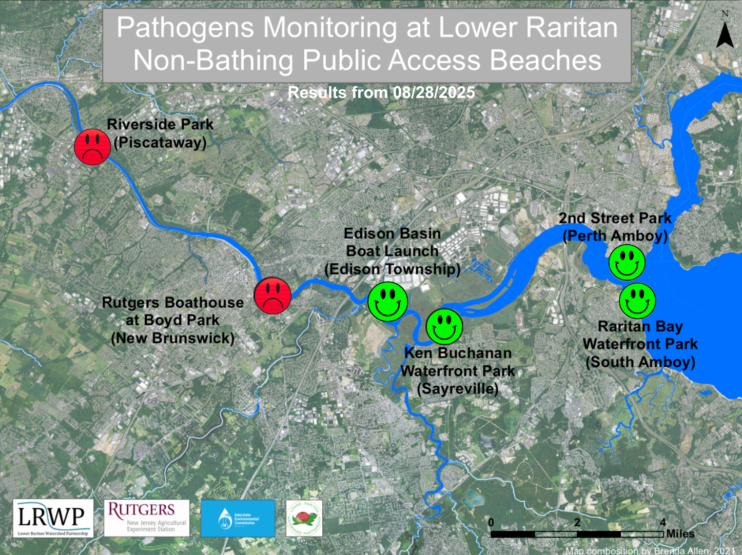
Our lab results for water quality samples taken on Thursday, August 28, 2025 show Enterococcus bacteria levels exceeding the EPA federal water quality standard of 104 cfu/100mL at two of our monitoring sites this week. Problem sites would be indicated by red frowns on the map and chart which includes: Riverside Park (Piscataway) and Rutgers Boat House (New Brunswick). Green smiles on the chart and map indicate the sites with bacteria levels safe for recreation, and include the following: Edison Boat Basin(Edison Township), Ken Buchanan Waterfront Park (Sayreville), Raritan Bay Waterfront Park (South Amboy), and 2nd Street Park (Perth Amboy).
Pathogens/Enterococci levels are used as indicators of the possible presence of disease-causing bacteria in recreational waters. Such pathogens may pose health risks to people coming in primary contact with the water (touching) through recreational activities like fishing, kayaking or swimming in a water body. Possible sources of bacteria include Combined Sewer Overflows (CSOs), improperly functioning wastewater treatment plants, stormwater runoff, leaking septic systems, animal carcasses, pet waste, wildlife waste, and runoff from manure storage areas.
Our goal in reporting these results is to give residents a better understanding of the potential health risks related to primary contact during water-based recreation. If you are planning on recreating on the Raritan this weekend, make sure to stay safe and wash up after any activities!
Two white-tailed deer (Odocoileus virginianus) sprint through Riverside Park. Photo credit: J.M. Meyer.
The range of the Chesapeake blue crab (Callinectes sapidus) extends far beyond the Chesapeake Bay. This deceased specimen was spotted floating in the Raritan River by Riverside Park, Piscataway. Photo credit: J.M. Meyer.
Beautiful weather draws Perth Amboy residents to recreate along the shore of the Raritan River at 2nd Street Park. Photo credit: J.M. Meyer.
The LRWP appreciates all of the hard work Ashley has put in this summer, and we wish her well as she returns to Rutgers for the fall semester! Photo credit: J.M. Meyer.
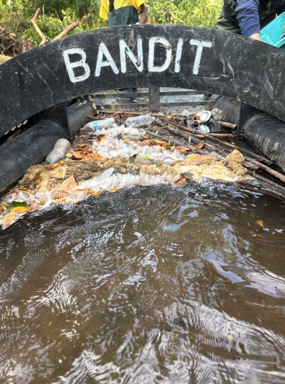
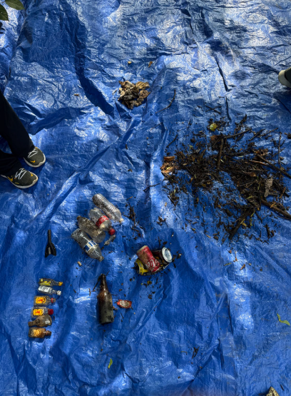
The LRWP and SEWA volunteers went out to the litter trap in the Green Brook on Saturday, August 9th, 2025, to conduct a litter tally. Huge thanks to our SEWA International Central Jersey youth partners! Thanks to their efforts, we’ll have much better data on how the litter trap keeps our watershed clean. Learn more about the litter trap initiative here. And learn more about the LRWP’s litter tally project with SEWA here. Below, you’ll find Sewa’s Nilesh Bhat describing the litter we picked up and conditions surrounding the litter trap.
Blog post by Yashashvi Pabbisetty
After several weeks of cleaning up and observing the Greenbrook stream and the litter trap, we have finished our final cleanup. During this meeting we noticed a significant amount of litter built up inside the trap as well as outside in the stream, met with two board members of the Lower Raritan Watershed Partnership, and ended the meeting by testing how various different pieces of litter go through the trap.
Trash Inside the Litter Trap:
4 plastic bottles
2 aluminum cans
1 glass bottle
1 paper wrapper
6 shot bottles
1 foam rocket
15-20 pieces of styrofoam
1 piece of cardboard
4 cigarette butts
Trash Outside the Litter Trap
1 broken down mattress
18 broken glass pieces
5 ceramic pieces
3 glass bottles
16 plastic bottles
8 aluminum cans
17 plastic wrappers
1 metal rod
2 tires
1 styrofoam food container
2 shot bottles
1 piece of fabric
1 strap
1 purse
1 toolbox piece with nails
26 plastic bags
1 umbrella
5 styrofoam pieces
1 piece of paper
During this meeting we had the opportunity to present to two members of the LRWP board, Nandini Checko and Anton Getz. First, we presented our findings from our group report on the storm which took place on July 14th, and then we discussed what we’ve learned about the litter trap. Afterwards, Dini and Anton shared their professional experiences with us, as well as their path to careers in environmental activism, safety, and science.
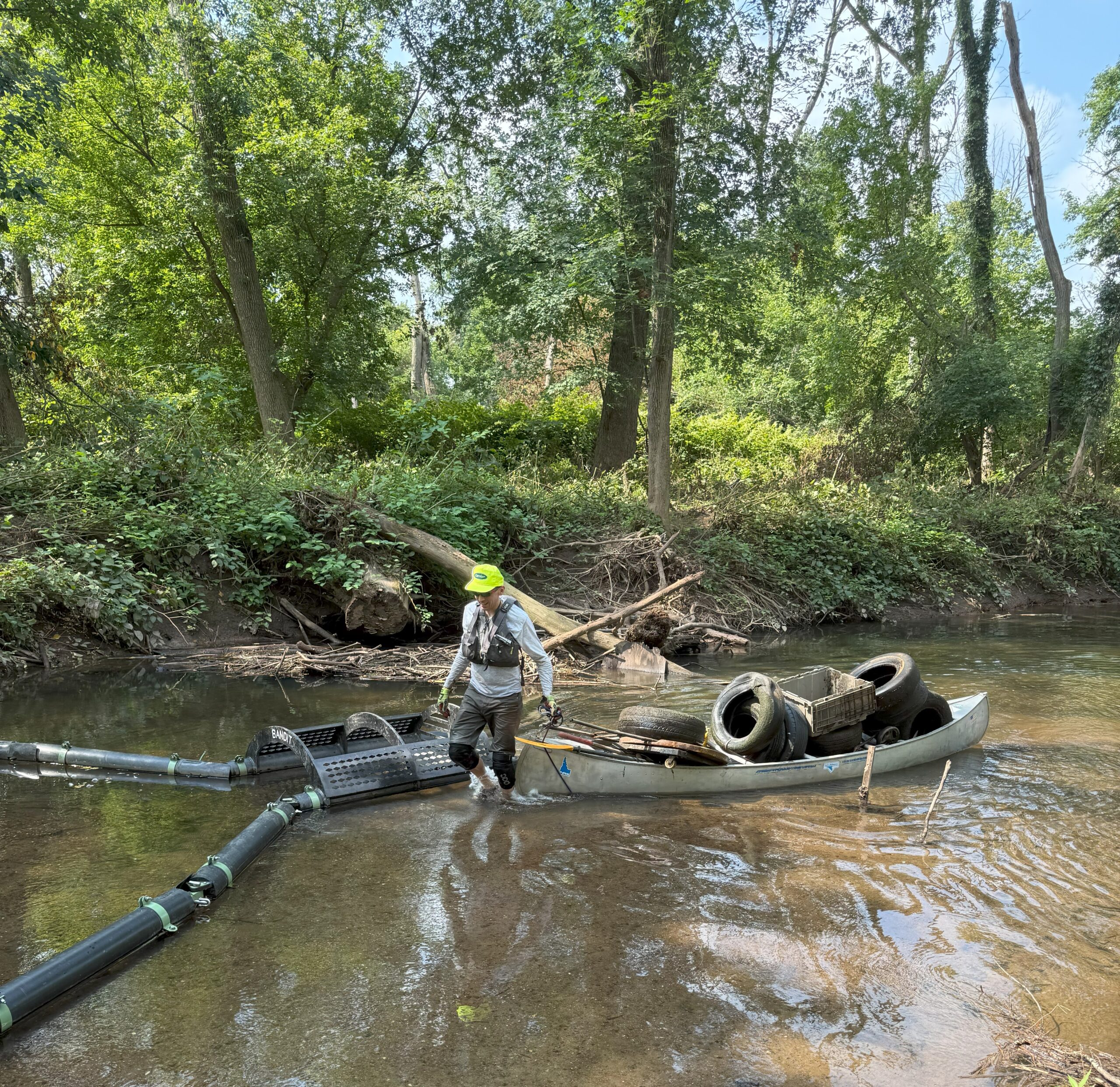
After our discussion, we collected and counted the litter. Anton helpfully brought a metal canoe to move swiftly through the stream, and collect tires and large objects; his canoe allowed him to float heavy debris up and down the stream.
Our meeting with Nandini and Anton gave us insights into the importance of the work that we do each week, how it fits into the bigger picture, and the ways in which volunteer organizations fill important gaps in the fight against plastic pollution.
To finish off our final meeting, we decided to each pick an item from the day’s cleanup to put back in the stream behind the litter trap and had a race; whichever item went into the trap first, would be victorious. This final experience answered a question that was on many of our minds: what item moves through the stream the fastest. The item which ended up winning was a piece of a styrofoam tray. This collaboration between the Sewa central jersey chapter volunteer organization and LRWP turned out as a huge success; we have gained accurate data about the trash flows in the Green Brook, and learned a tremendous amount about riparian floodways, environmental activism, plastic pollution, and community engagement!
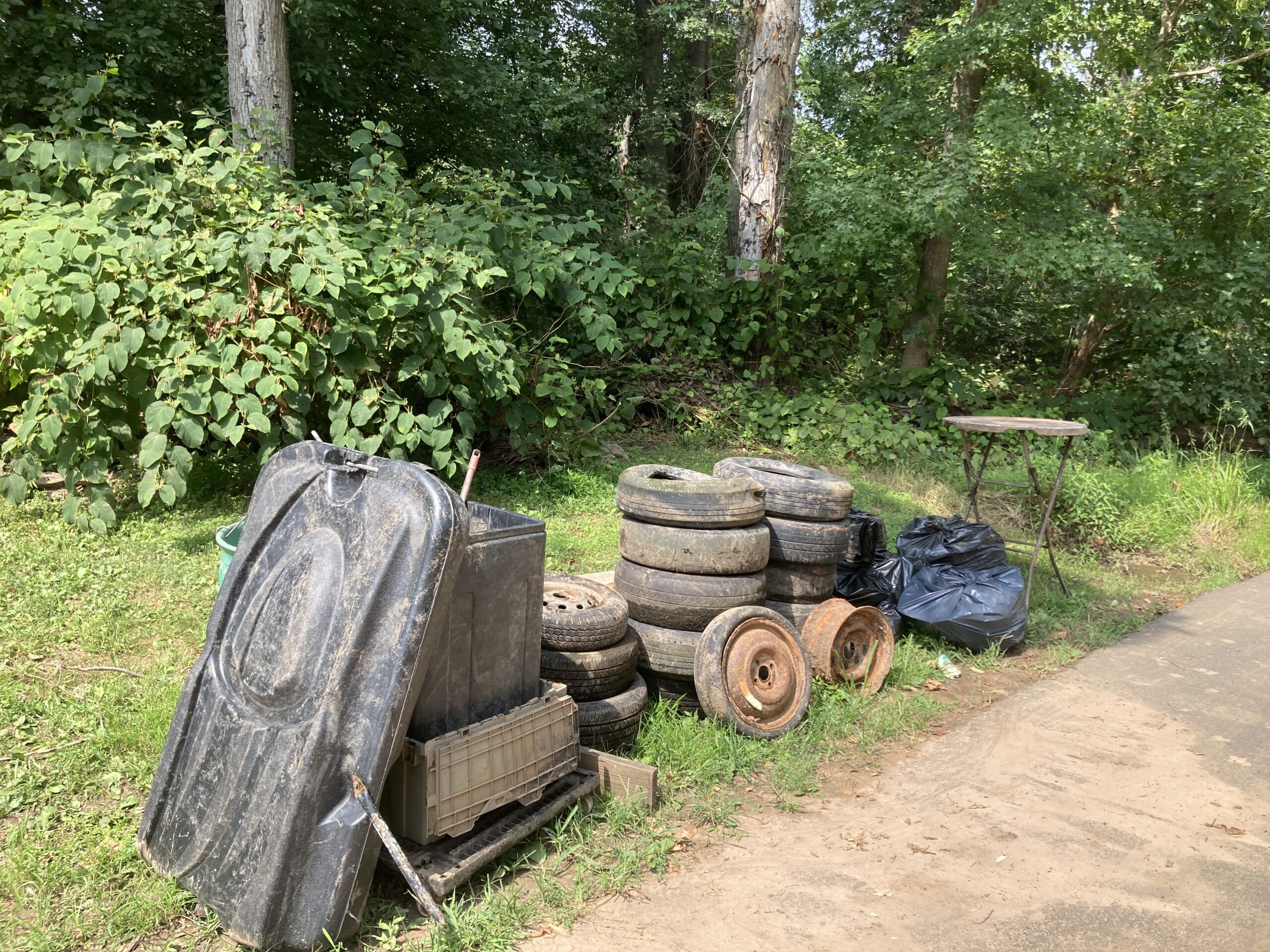
The trash is neatly stacked and ready for pickup by our partners at the Dunellen Department of Public Works. Thank you, Dunellen!
The LRWP and SEWA volunteers went out to the litter trap in the Green Brook on Saturday, August 9th, 2025, to conduct a litter tally. Huge thanks to our SEWA International Central Jersey youth partners! Thanks to their efforts, we’ll have much better data on how the litter trap keeps our watershed clean. Learn more about the litter trap initiative here. And learn more about the LRWP’s litter tally project with SEWA here. Below, you’ll find Sewa’s Nilesh Bhat describing the litter we picked up and conditions surrounding the litter trap.
Blog post by Aasmi Bora
This past week, the litter trap was heavily impacted by the flash floods that occurred on 7/31. Unlike our usual schedule, this cleanup was after two weeks and not one. The trap had accumulated hundreds of tree branches: caught inside, lodged under it, or beside it. Luckily, with the help of our Sewa volunteers, we were able to completely remove all of the organic matter surrounding the litter trap, restoring its ability to freely collect waste without any obstruction.
This week, we collecting the following litter from inside the trap:
11 shot bottles
1 prescription container
20 plastic bottles
1 glass bottle
1 bottom of a basketball hoop
1 soccer ball
1 marker
1 headlight
1 cigar
8 aluminum cans
1 eye drop
1 nail separator
about 20-30 pieces of styrofoam
1 tire
1 wooden slab
1 juice box
We also found litter outside the trap:
6 glass bottles
1 hand sanitizer
1 lighter
1 tennis ball
22 plastic bottles
4 shot bottles2 plastic container
2 eye drops
1 half of an easter egg
5 aluminum cans
4 plastic bottle caps
1 fishing bobble
1 straw
About 110 pieces of styrofoam
1 test kit
1 plastic piece
2 slabs of insulation
1 shovel bottom
1 shoe
16 plastic bags
2 balloons
1 piece of glass
1 marker
This week, we observed that the majority of the styrofoam we collected had been damaged by fire. The styrofoam pieces were also much larger in comparison to what we have collected in the past. There was also a multitude of building materials in the collection this week.
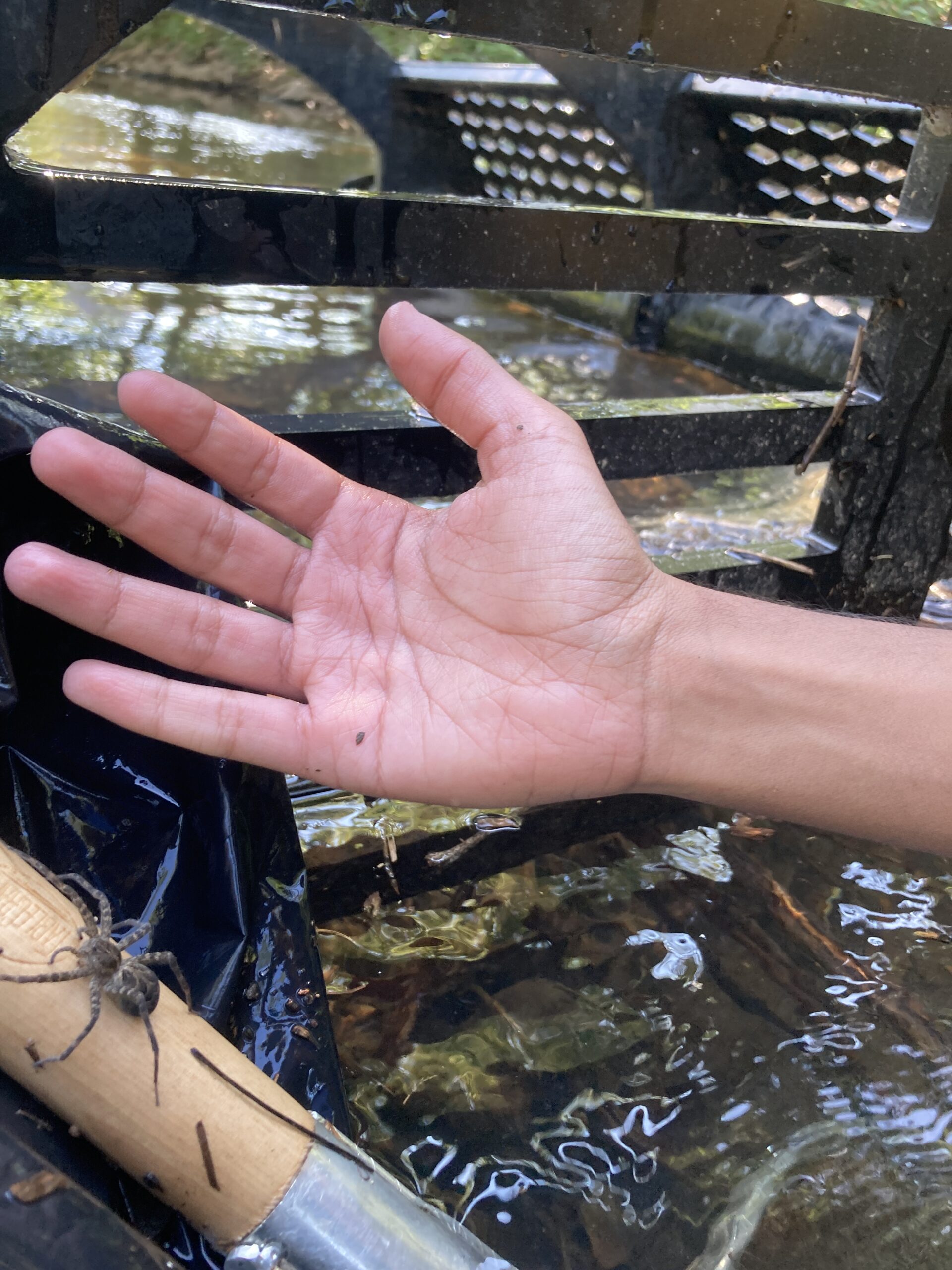
Finally, we found a large fishing spider hiding among the trash in the debris!
A fishing spider (dolomedes tenebrosus) was found in the litter trap.
As we have been conducting this project for the past few weeks, we have been exploring ways to improve the litter trap’s design. This week’s cleanup allowed us to witness how organic matter, such as a tree branch, was able to act as a net and catch a large portion of the litter that was collected in the trap. We found that organic matter is used in many countries, especially in smaller villages, to prevent the debris from moving forward. Often known as debris barriers, the use of organic matter is especially convenient when collecting smaller pieces of waste like Styrofoam which can be tedious to collect by hand due to the size of some Styrofoam pieces. However, we also have to consider that these natural barriers may require some upkeep in order to remain effective.
This cleanup was very insightful and provided us with more ways to make the litter trap a much more convenient and more efficient mechanism.
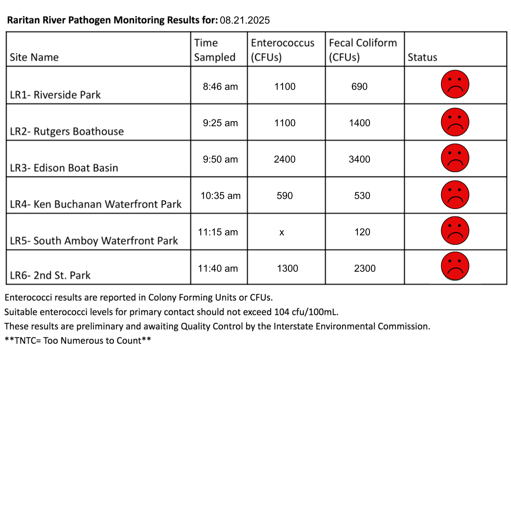
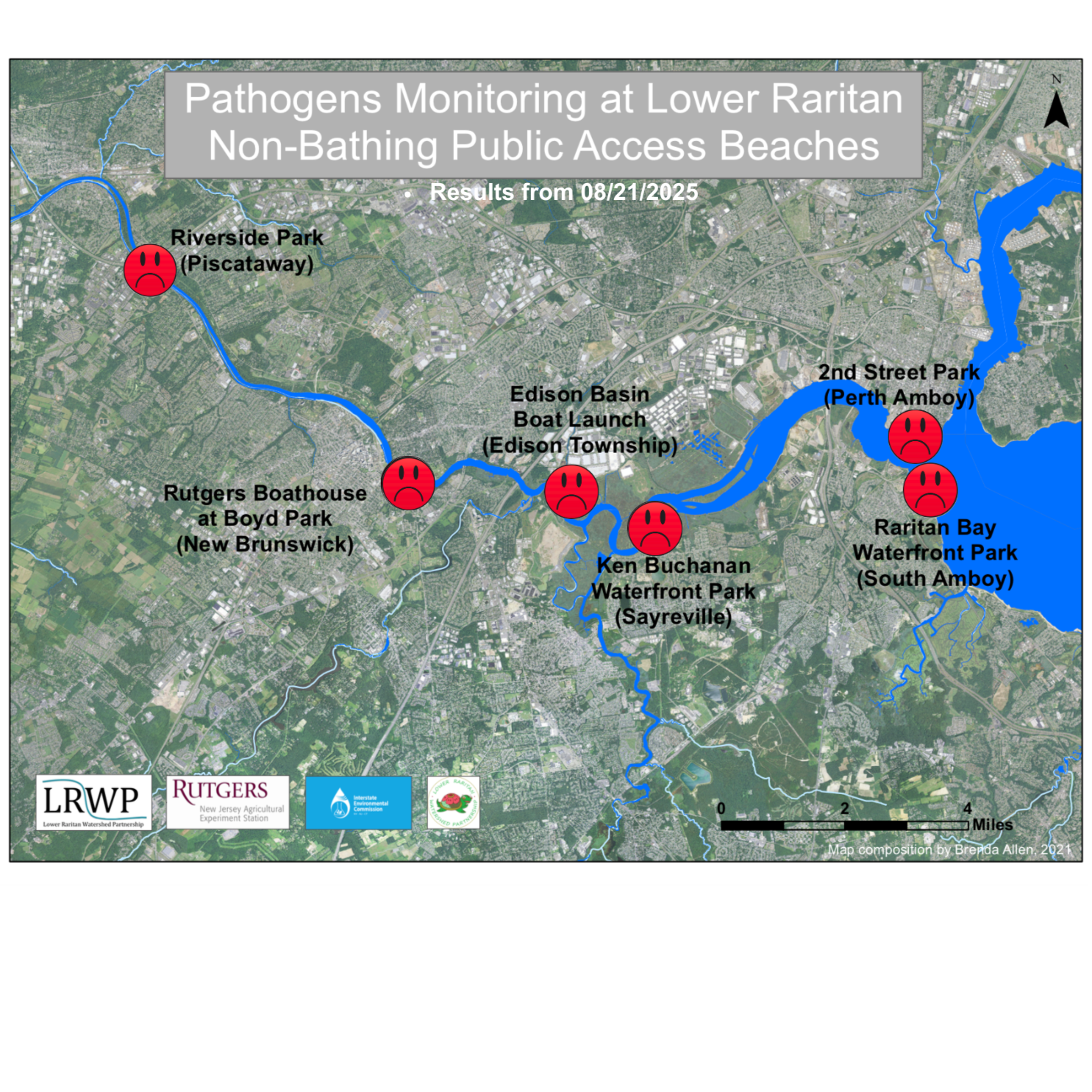
The third pathogen monitoring session of the month took place on Thursday, August 21st. Each week during the summer, from May to October, the Lower Raritan Watershed Partnership and Rutgers Cooperative Extension of Middlesex County run a volunteer-based monitoring program along the Raritan River. We collect water quality samples at six non-bathing public access beach sites, provide our samples to the Interstate Environmental Commission for analysis in their laboratory, and report the results to the public. Our mission is to share this data with the community and partners to ensure the safe use of the Raritan river for all.
Our lab results for water quality samples taken on Thursday, August 21, 2025 show Enterococcus bacteria levels exceeding the EPA federal water quality standard of 104 cfu/100mL at five of our monitoring sites this week. On the chart below, red frowns indicate problem sites, and these include Riverside Park (Piscataway), Rutgers Boat House (New Brunswick), Edison Boat Basin(Edison Township), Ken Buchanan Waterfront Park (Sayreville), and 2nd Street Park (Perth Amboy).
We do not have complete data for South Amboy due to an abnormality in the lab results. Out of an abundance of caution, we are issuing a red smiley face to South Amboy as well. If the status of the lab result changes and we receive a different verdict from the Interstate Environmental Commission (IEC), then we will update our chart and map on this blog and on our social media.
Green smiles on the chart and map indicate the sites with bacteria levels safe for recreation. Unfortunately, we are not handing out any green smiles this week.
Pathogens/Enterococci levels are used as indicators of the possible presence of disease-causing bacteria in recreational waters. Such pathogens may pose health risks to people coming in primary contact with the water (touching) through recreational activities like fishing, kayaking or swimming in a water body. Possible sources of bacteria include Combined Sewer Overflows (CSOs), improperly functioning wastewater treatment plants, stormwater runoff, leaking septic systems, animal carcasses, pet waste, wildlife waste, and runoff from manure storage areas.
Our goal in reporting these results is to give residents a better understanding of the potential health risks related to primary contact during water-based recreation. If you are planning on recreating on the Raritan this weekend, make sure to stay safe and wash up after any activities!
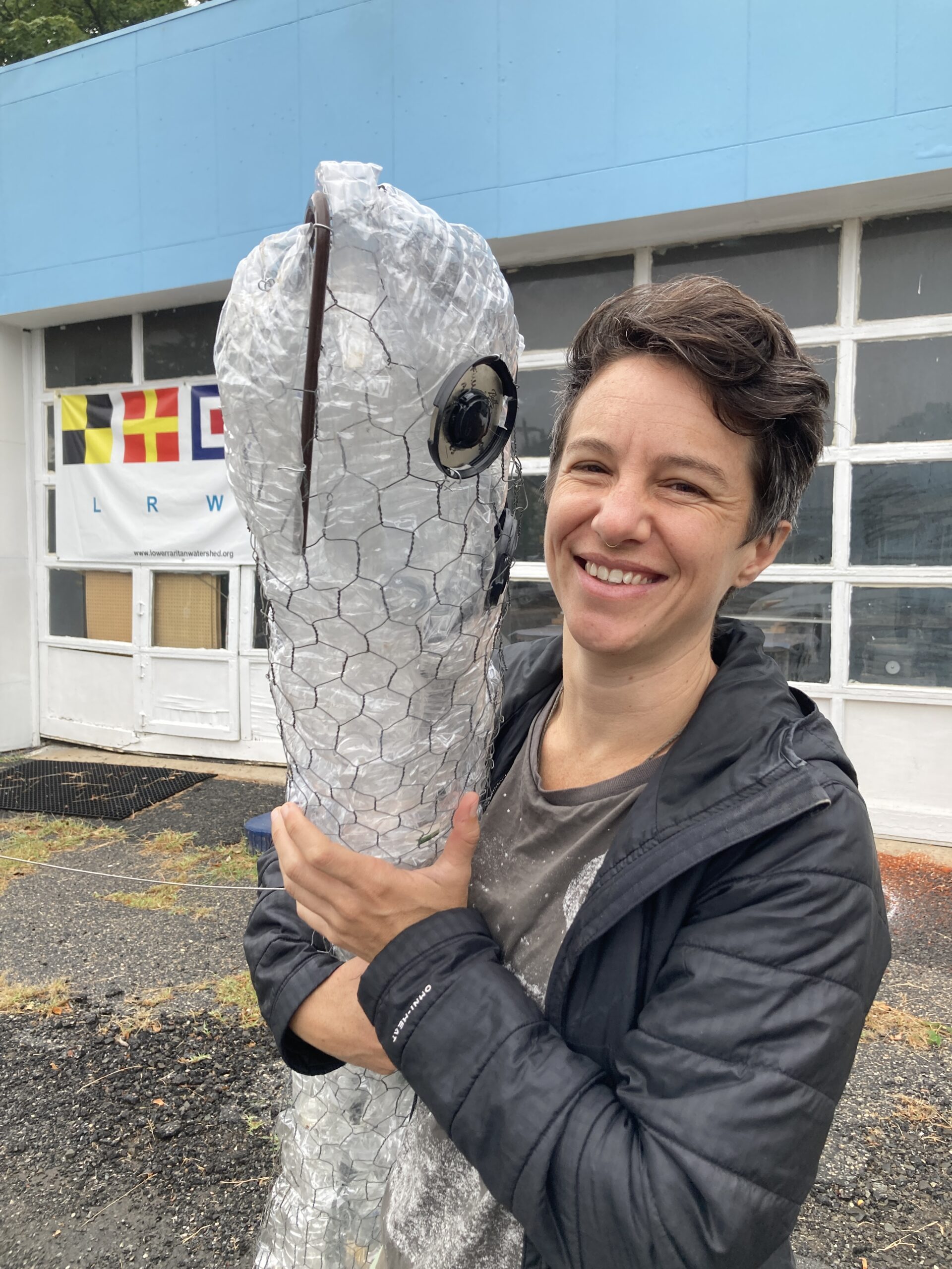
Internationally-acclaimed artist Ania Upstill volunteered for pathogen monitoring this week! In this photo, Ania greets Elver the eel. At each of our sites, Ania picked up litter and learned about how the Raritan River Watershed has been affected by nonpoint source pollutants. Photo credit: –J.M. Meyer.
A fisher at Edison Boat Basin takes advantage of the cloudy day and the dock ramp. Photo credit: –Art Allgauer.
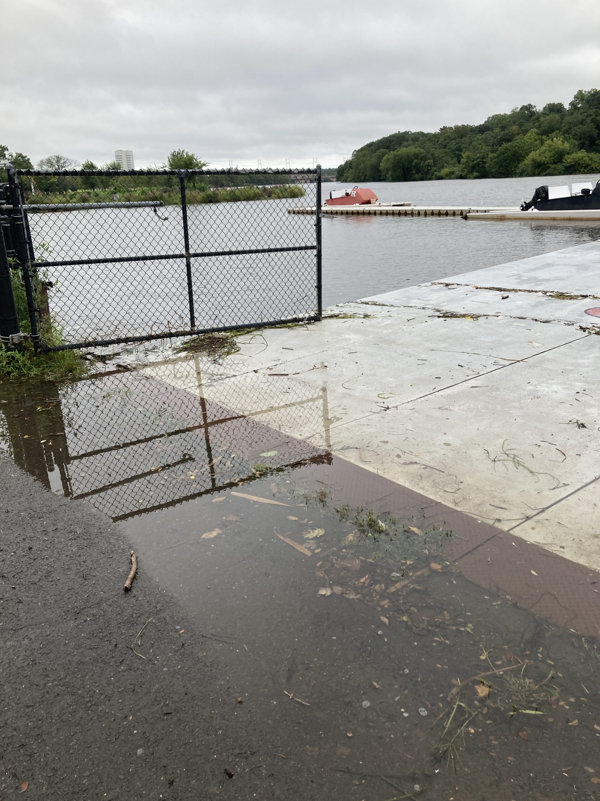
High tide combined with the outer bands of Hurricane Erin led to flooding at the Class of 1914 Rutgers Boat House in New Brunswick. Photo credit: –J.M. Meyer.
Rutgers coaches help their athletes navigate a swollen Raritan River near Rutgers Boat House. Photo credit: — Art Allgauer.
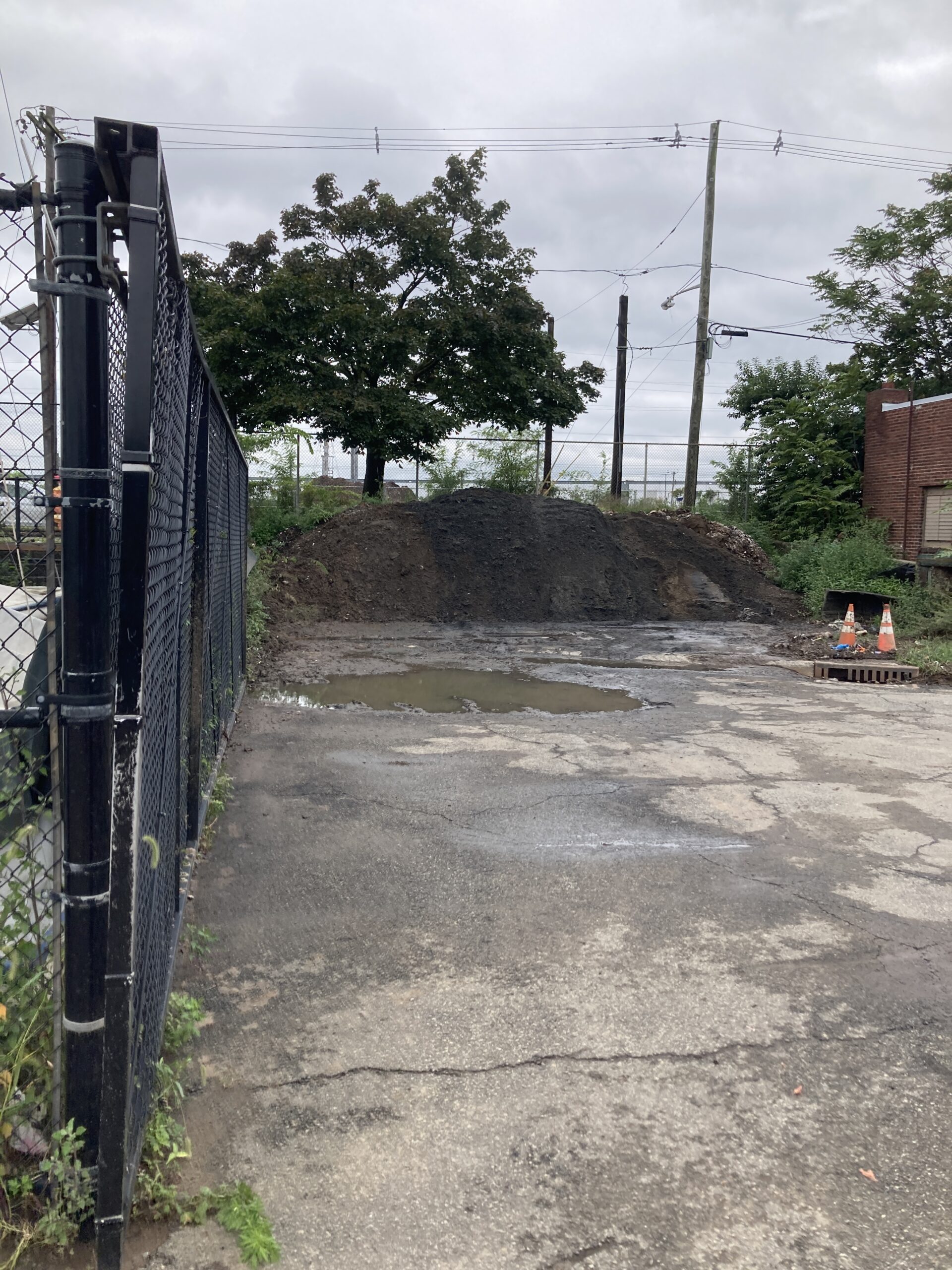
In Perth Amboy, the pile of sanitary products and sewage sediment has been partially capped by top soil. The sewage smell is less noticeable compared to previous visits, but still present. Photo credit: –J.M. Meyer.
In the sample from Sayreville, our IEC lab technicians found a moon jellyfish (Aurelia aurita)! Though jellyfish are often thought of as ocean animals, some species enjoy the brackish waters such as those found at the Ken Buchanan Waterfront Park. Photo credit: –Ruby Alcorn.
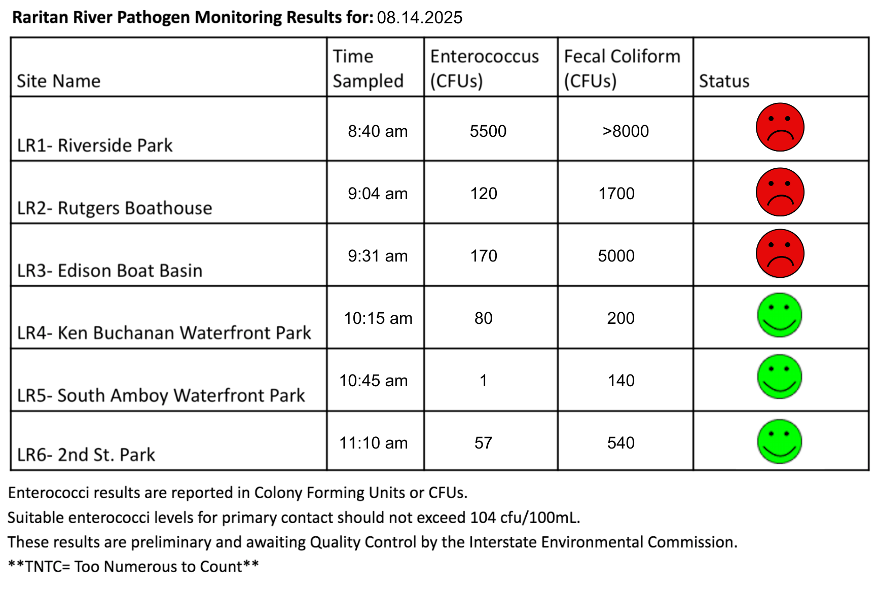
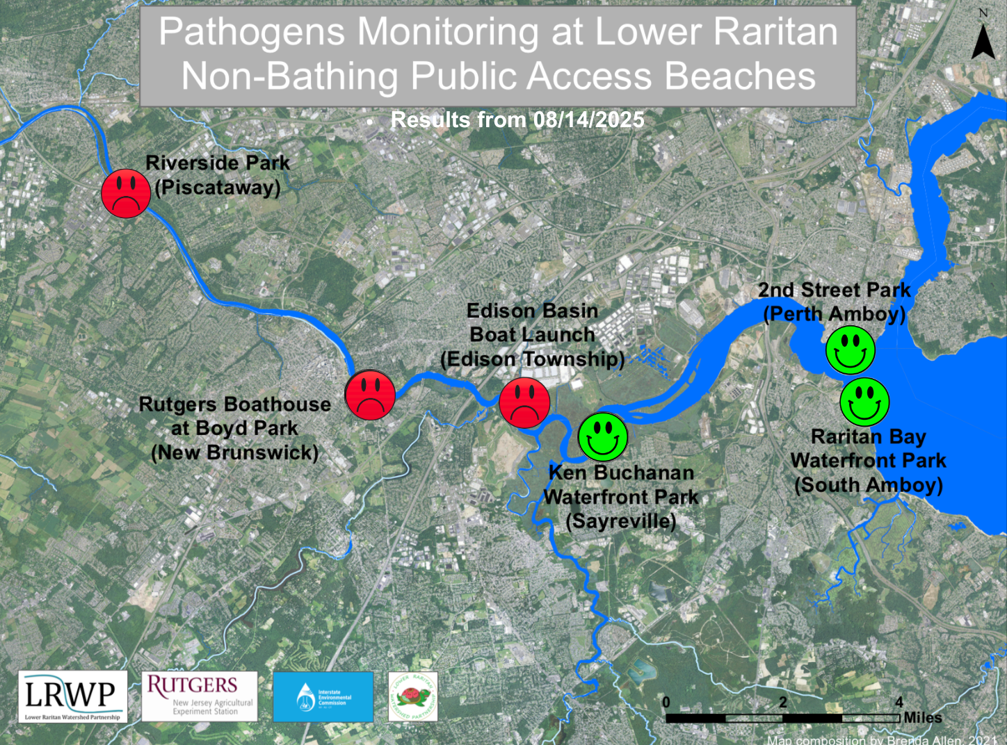
The second pathogen monitoring session of the month took place on Thursday, August 14th. Each week during the summer, from May to October, the Lower Raritan Watershed Partnership and Rutgers Cooperative Extension of Middlesex County run a volunteer-based monitoring program along the Raritan River. We collect water quality samples at six non-bathing public access beach sites, provide our samples to the Interstate Environmental Commission for analysis in their laboratory, and report the results to the public. Our mission is to share this data with the community and partners to ensure the safe use of the Raritan river for all.
Our lab results for water quality samples taken on Thursday, August 14, 2025 show Enterococcus bacteria levels exceeding the EPA federal water quality standard of 104 cfu/100mL at three of our monitoring sites this week. Problem sites would be indicated by red frowns on the map and chart which includes: Riverside Park (Piscataway), Rutgers Boat House (New Brunswick), and Edison Boat Basin(Edison Township). Green smiles on the chart and map indicate the sites with bacteria levels safe for recreation, and include the following: Ken Buchanan Waterfront Park (Sayreville), Raritan Bay Waterfront Park (South Amboy), and 2nd Street Park (Perth Amboy).
Pathogens/Enterococci levels are used as indicators of the possible presence of disease-causing bacteria in recreational waters. Such pathogens may pose health risks to people coming in primary contact with the water (touching) through recreational activities like fishing, kayaking or swimming in a water body. Possible sources of bacteria include Combined Sewer Overflows (CSOs), improperly functioning wastewater treatment plants, stormwater runoff, leaking septic systems, animal carcasses, pet waste, wildlife waste, and runoff from manure storage areas.
Our goal in reporting these results is to give residents a better understanding of the potential health risks related to primary contact during water-based recreation. If you are planning on recreating on the Raritan this weekend, make sure to stay safe and wash up after any activities!
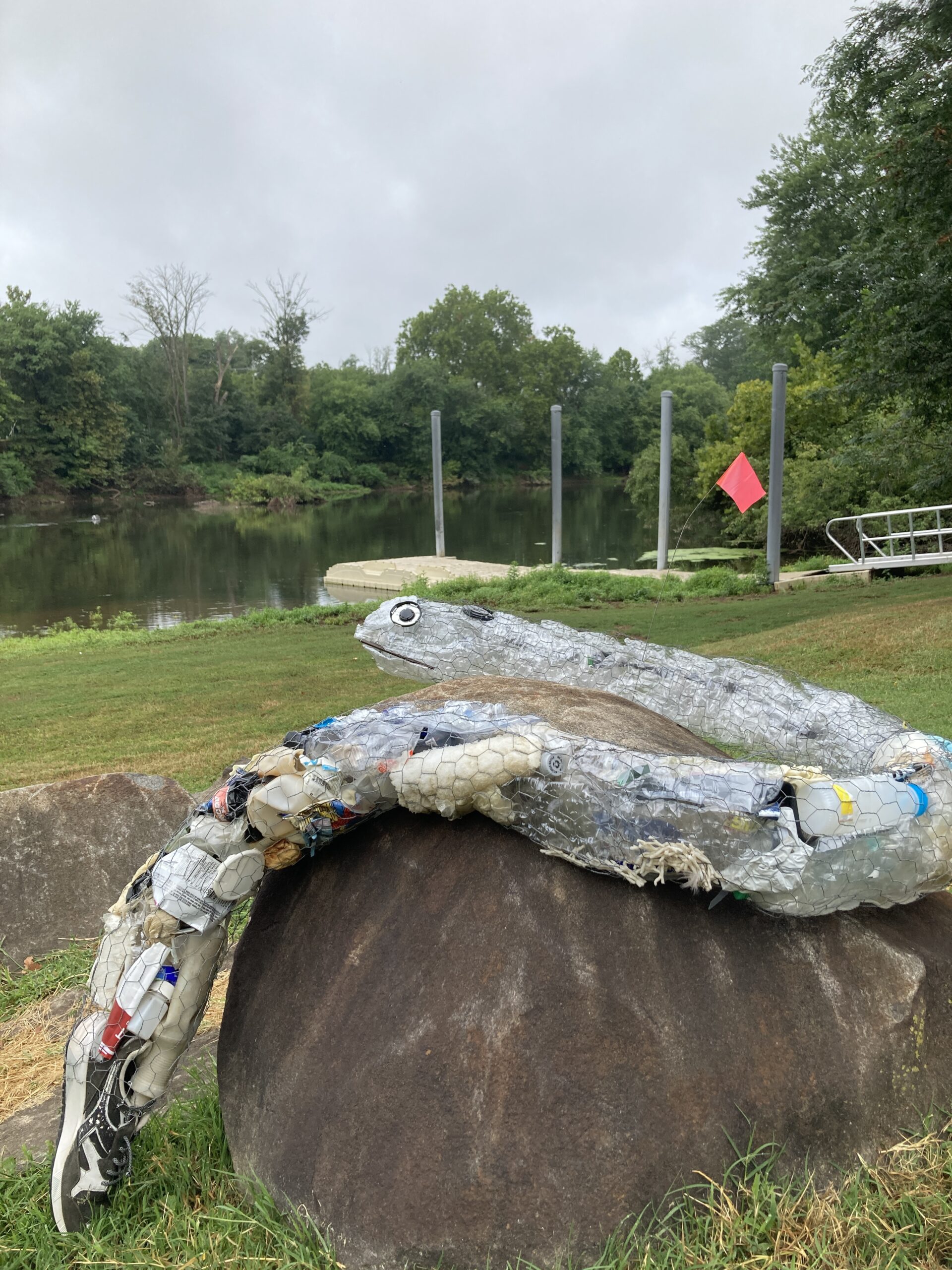
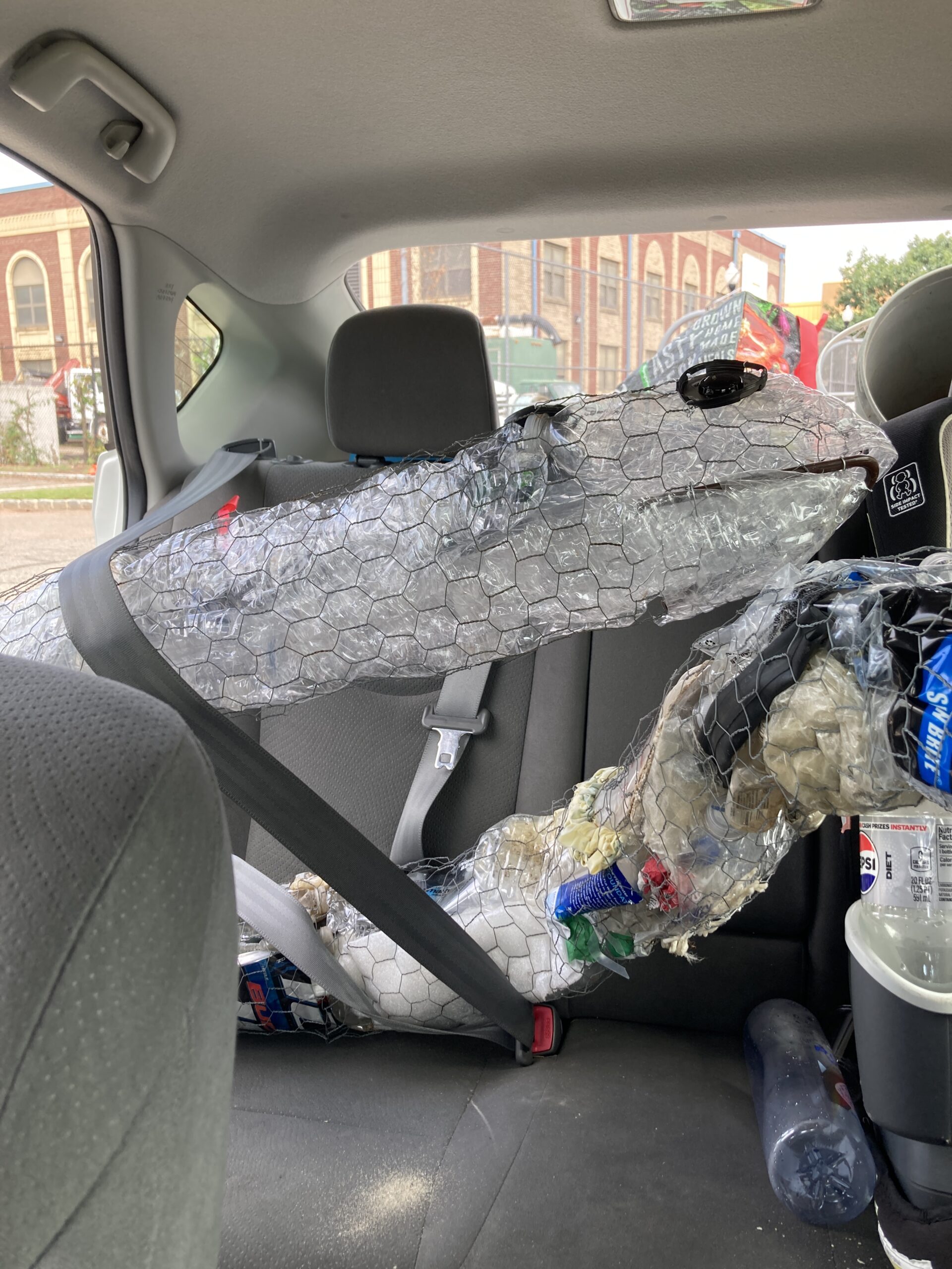
Elver the Eel joins volunteers for water monitoring at Riverside Park. Artist Lisa Bagwell constructed Elver entirely out of trash from the Raritan River, making him the only American eel (Anguilla rostrata) able to survive out of water for so long! Instead of migrating to the Sargasso Sea to mate with other eels, Elver migrates from school to school to educate students about water quality. Photo credit: J.M. Meyer.
During a visual habitat assessment of Riverside Park, Elver notices the land has been mowed down right to the water line. Unfortunately, this prevents the riparian plant life from filtering pollutants out of our water. This can contribute to poor water quality. Photo credit: J.M. Meyer.
Invasive emerald ash borers (Agrilus planipennis) have killed many of the white ash trees (Fraxinus americana) near the Raritan River. Less shade means hotter water and more algal blooms, making it unpleasant for Elver to swim. Photo credit: J.M. Meyer.
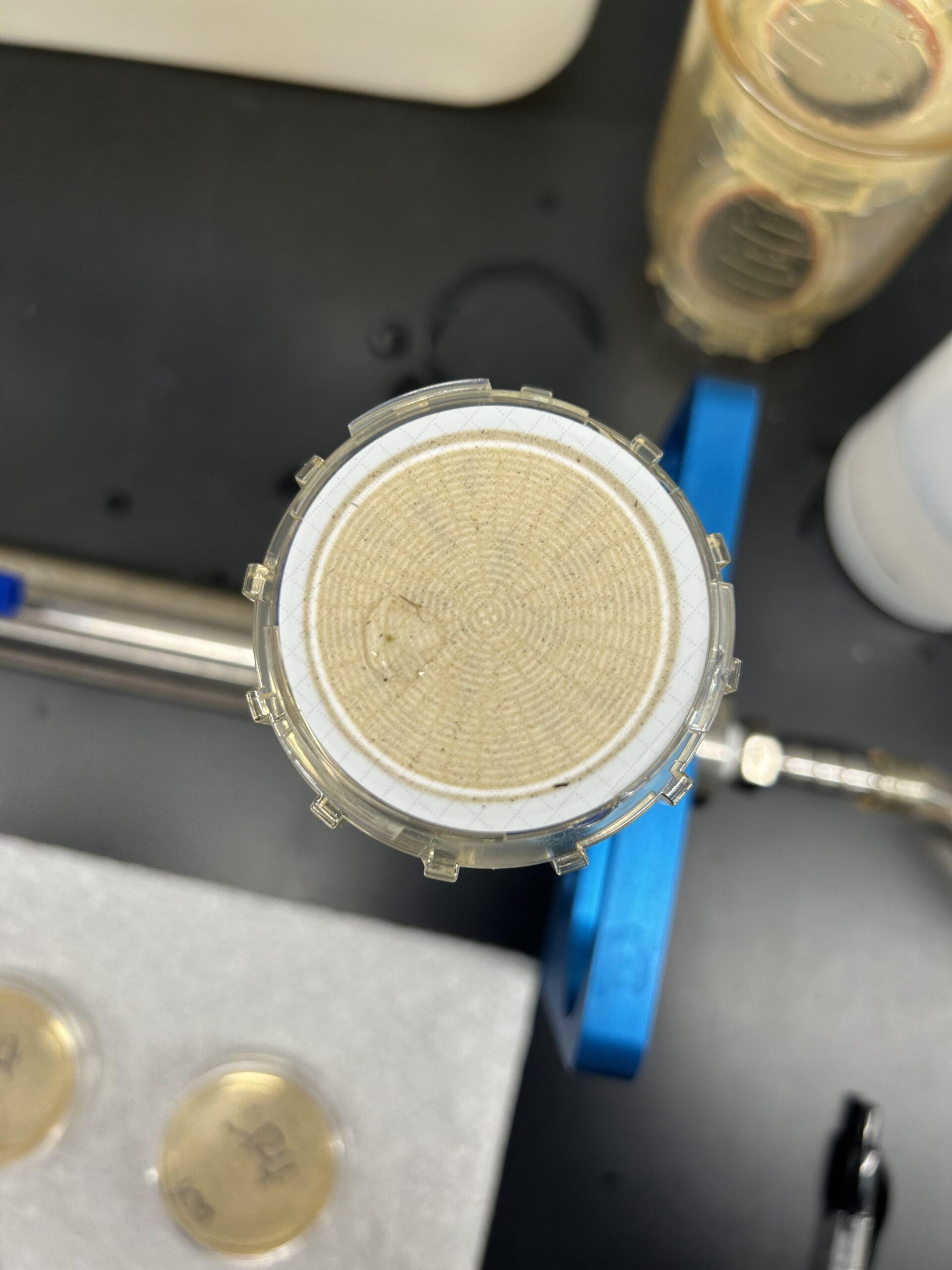
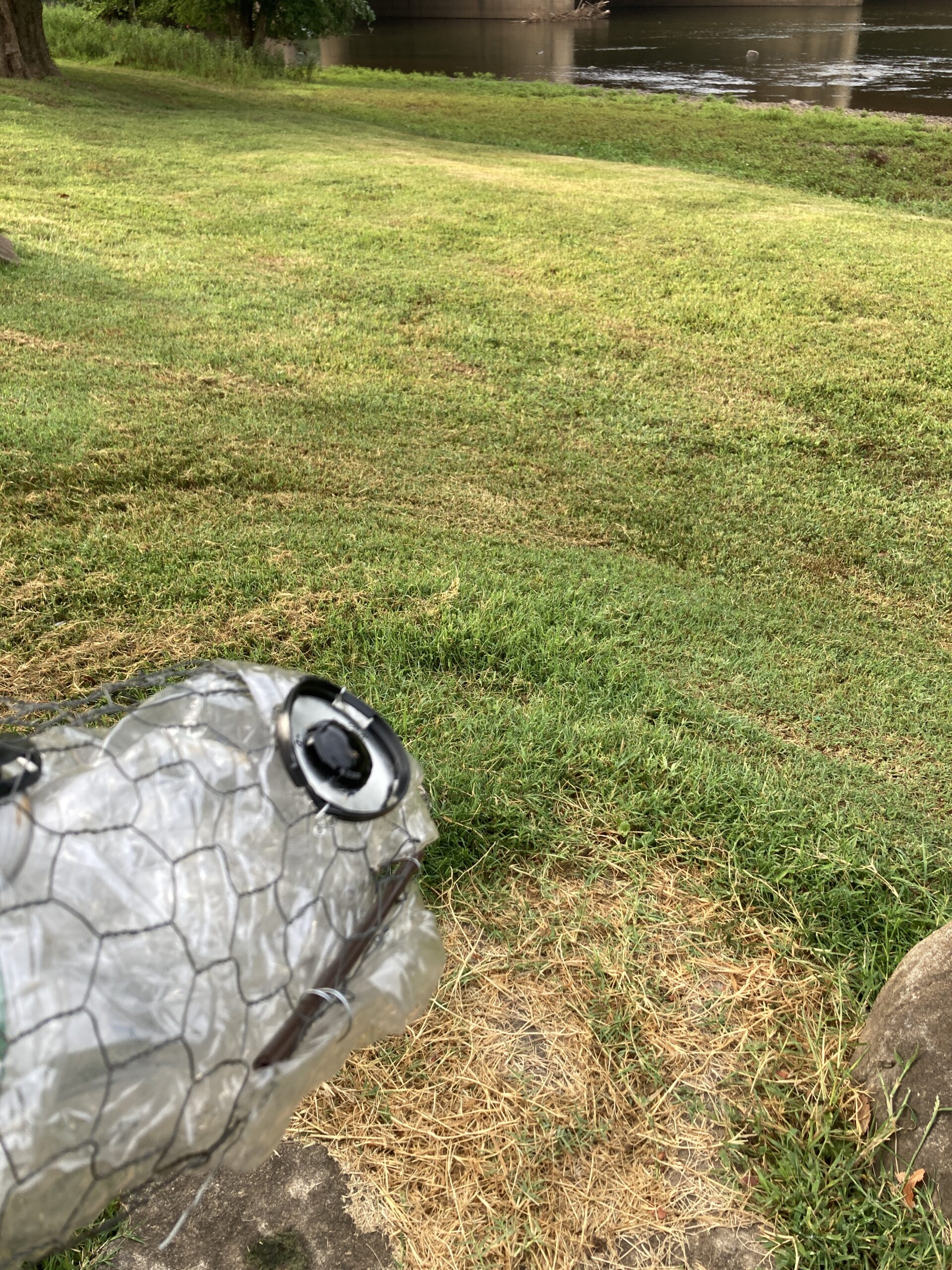
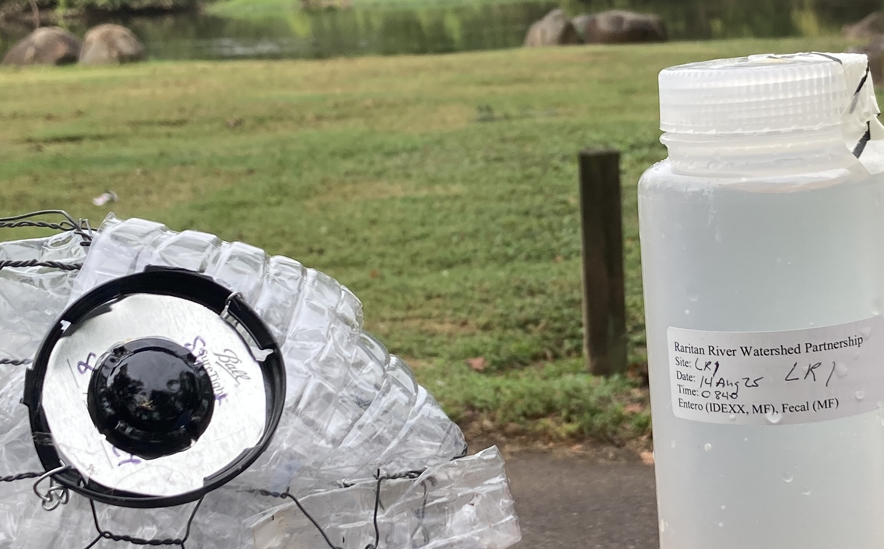
Elver visually inspects the Riverside Park (LR1) water sample before sending it off to the lab. Yikes! Lab analysis the next day showed that Piscataway’s Riverside Park is suffering from fecal polluted water. Photo credit: J.M. Meyer.
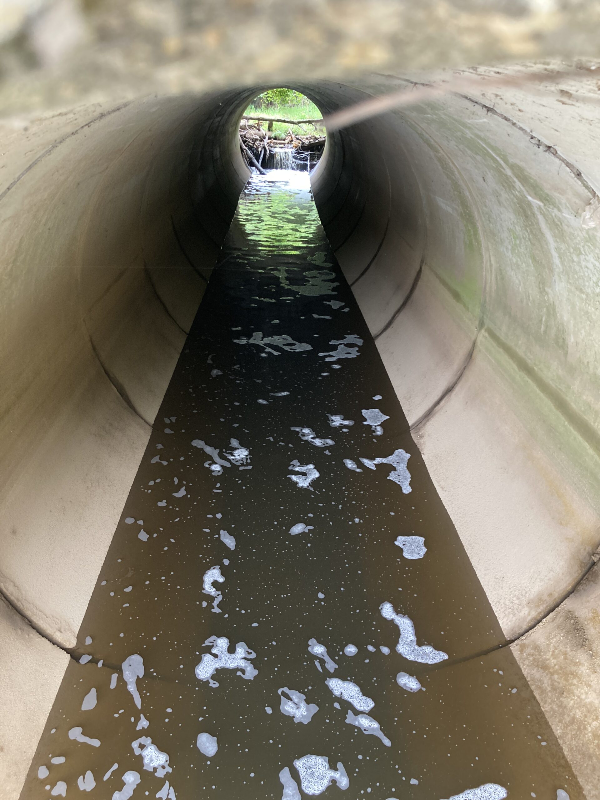
Ashley observes how the massive culvert of Mill Brook flows into the Edison Boat Basin, eroding the far shore and carrying debris from the Kin-Buc Landfill Superfund Site. Photo credit: J.M. Meyer.
Natural sources of foam include plant matter decaying, runoff, and turbulence, such as the waterfall at the mouth of the culvert. Photo credit: J.M. Meyer
An ash log creates a waterfall flowing into the culvert at Mill Brook in Edison Boat Basin. Photo credit: J.M. Meyer.
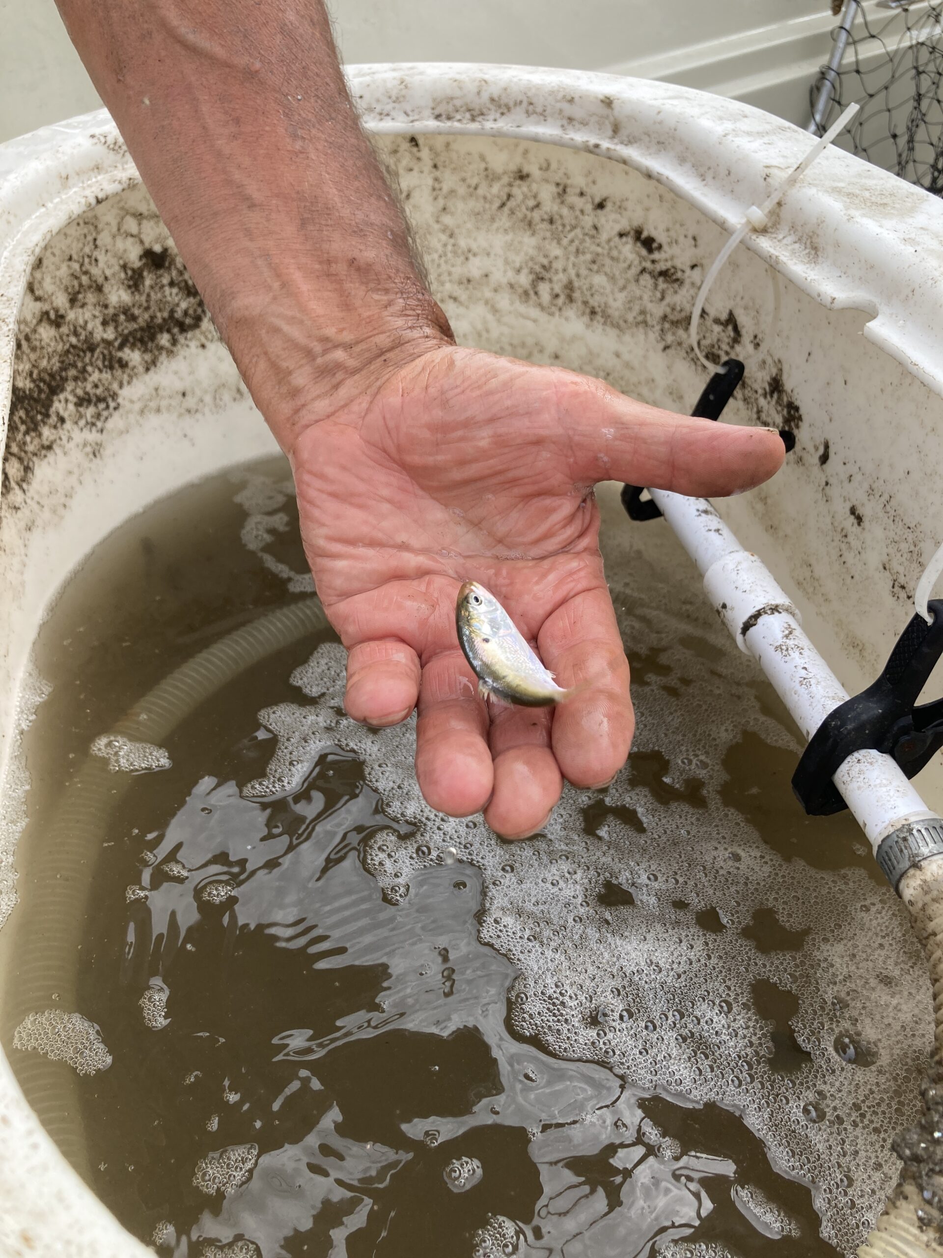
A fisherman displays a juvenile white mullet (Mugil curema) he caught in Sayreville. When handling fish like this juvenile white mullet, be gentle and return them to the water as quickly as possible! Photo credit: J.M. Meyer.
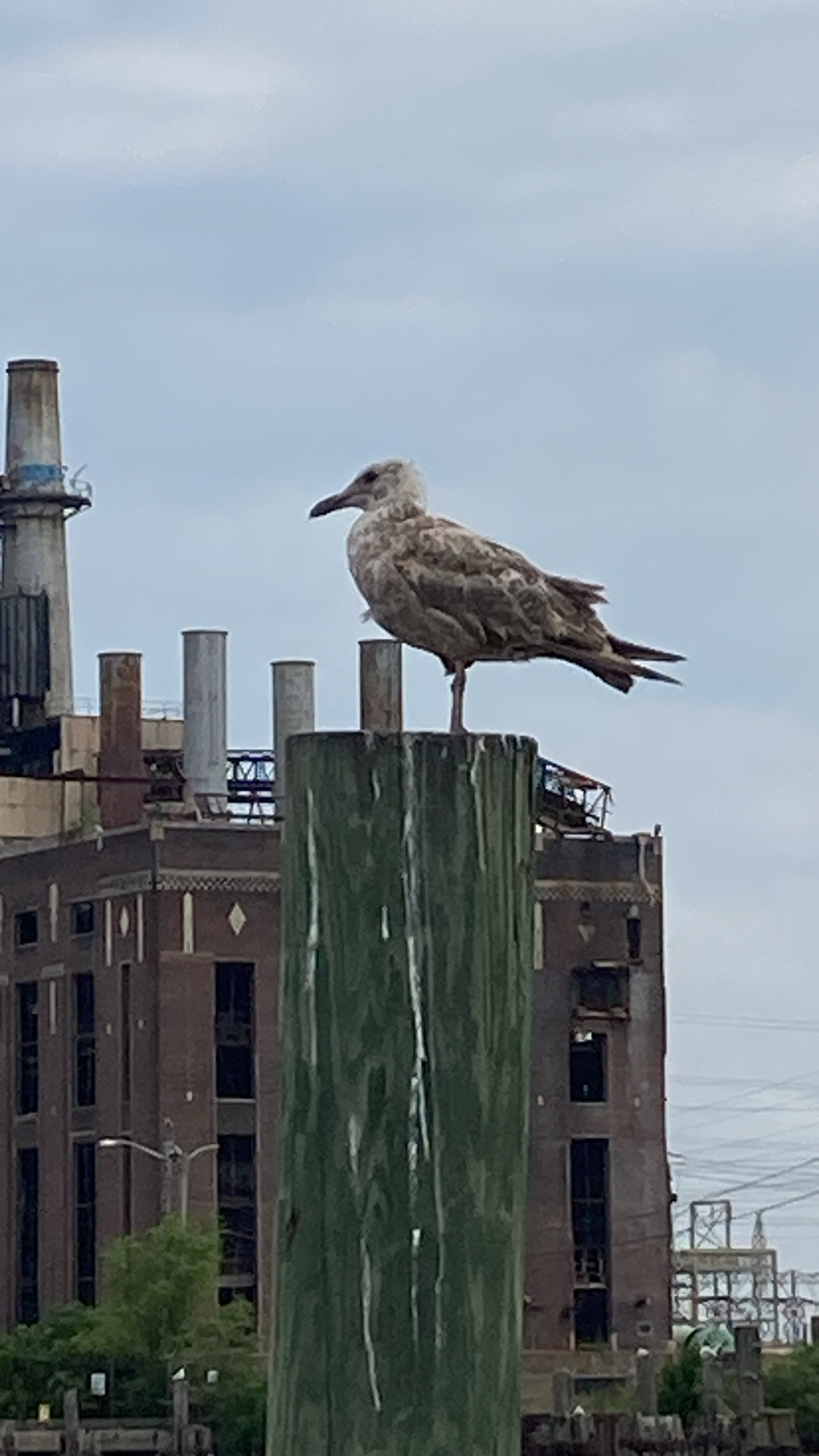
This juvenile European herring gull (Larus argentatus) will look very different as an adult, trading its mottled white and brown feathers for a mostly white body with gray wings and black accents. Photo credit: J.M. Meyer.
Driving between sites is perhaps the most dangerous part of water monitoring. Buckle up, Elver! Photo credit: J.M. Meyer.
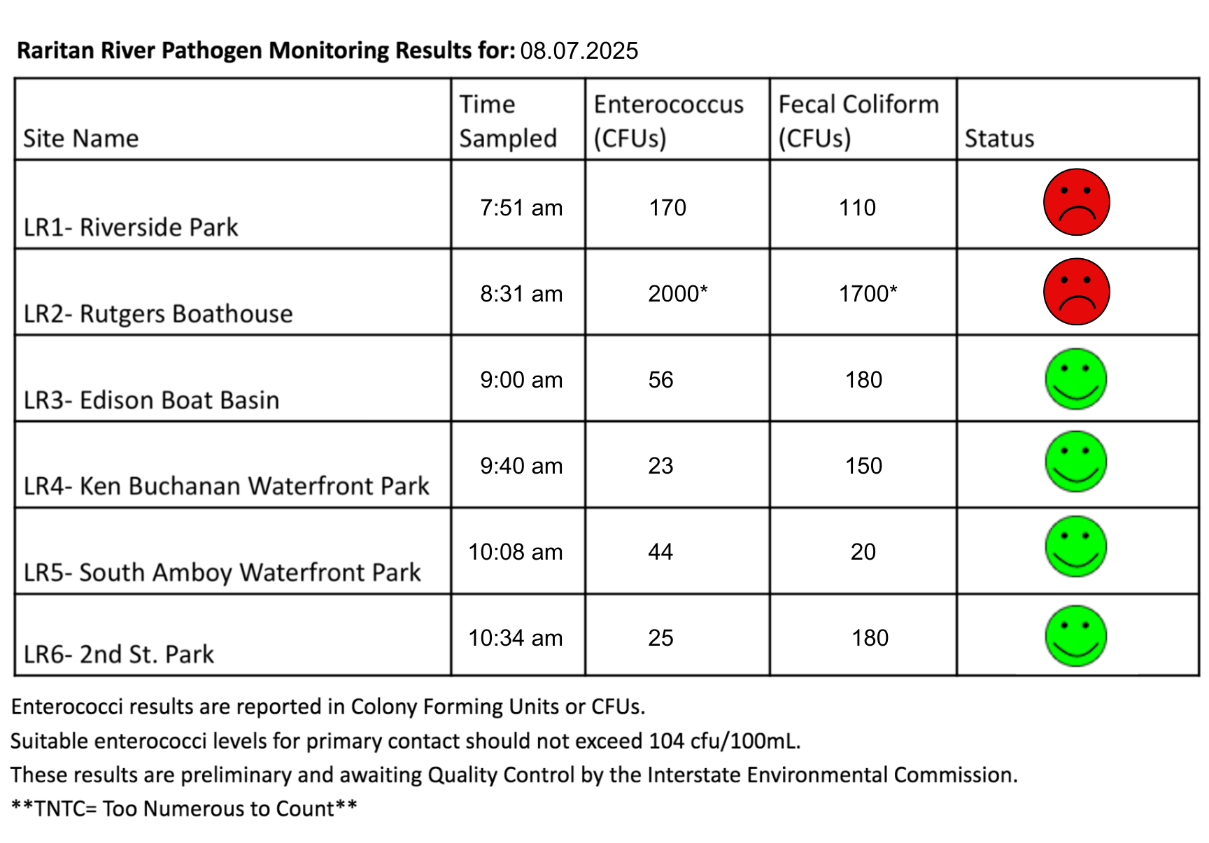
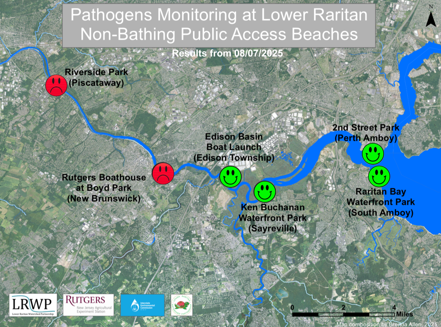
The first pathogen monitoring session of the month took place on Thursday, August 8th. Each week during the summer, from May to October, the Lower Raritan Watershed Partnership and Rutgers Cooperative Extension of Middlesex County run a volunteer-based monitoring program along the Raritan River. We collect water quality samples at six non-bathing public access beach sites, provide our samples to the Interstate Environmental Commission for analysis in their laboratory, and report the results to the public. Our mission is to share this data with the community and partners to ensure the safe use of the Raritan river for all.
This week, we were so pleased that Piscataway Council Members Laura Leibowitz and Sarah Rashid joined us for our monitoring session at Riverside Park. Ultimately, we’ll need the help of talented leaders like Laura and Sarah in order to find ways of solving the challenges presented by non-point pollutants in our community.
Our lab results for water quality samples taken on Thursday, August 8, 2025 show Enterococcus bacteria levels exceeding the EPA federal water quality standard of 104 cfu/100mL at two of our monitoring sites this week. Problem sites would be indicated by red frowns on the map and chart which includes: Riverside Park (Piscataway) and Rutgers Boat House (New Brunswick). Green smiles on the chart and map indicate the sites with bacteria levels safe for recreation, and include the following: Edison Boat Launch (Edison Township), Ken Buchanan Waterfront Park (Sayreville), Raritan Bay Waterfront Park (South Amboy), and 2nd Street Park (Perth Amboy).
Sampling in New Brunswick was conducted 100m further downstream than usual, at the Boyd Park boat ramp instead of Rutgers Boat House. The water at the ramp is stagnant and immediately downstream of an outfall, and those factors may have contributed to the unusually high amount of Enterococci recorded at LR2 this week.
Pathogens/Enterococci levels are used as indicators of the possible presence of disease-causing bacteria in recreational waters. Such pathogens may pose health risks to people coming in primary contact with the water (touching) through recreational activities like fishing, kayaking or swimming in a water body. Possible sources of bacteria include Combined Sewer Overflows (CSOs), improperly functioning wastewater treatment plants, stormwater runoff, leaking septic systems, animal carcasses, and runoff from manure storage areas.
Our goal in reporting these results is to give residents a better understanding of the potential health risks related to primary contact during water-based recreation. If you are planning on recreating on the Raritan this weekend, make sure to stay safe and wash up after any activities!
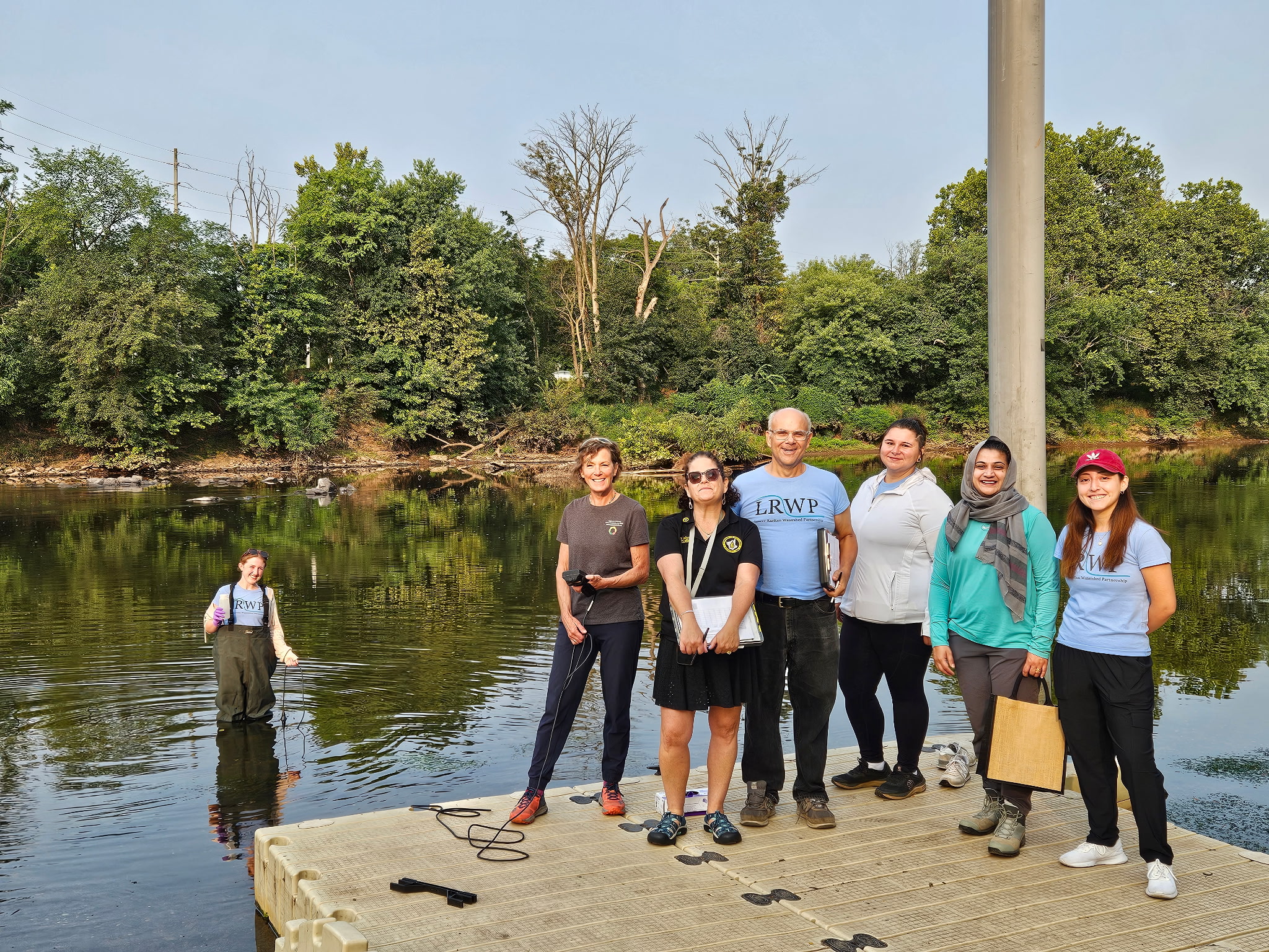
At Riverside Park, we were thrilled that Piscataway Council Members Laura Leibowitz and Sarah Rashid joined us for the water monitoring session! Special thanks to volunteers Ashley Fritz (in waders), Amy Hahn, Art, and Rose — and yes, that’s Jocelyn on the far right! She covered down on water monitoring duties so that Dr. John could lead a nature walk for our partners at CoLab. Thank you, everyone! Photo credit: — Heather Fenyk.
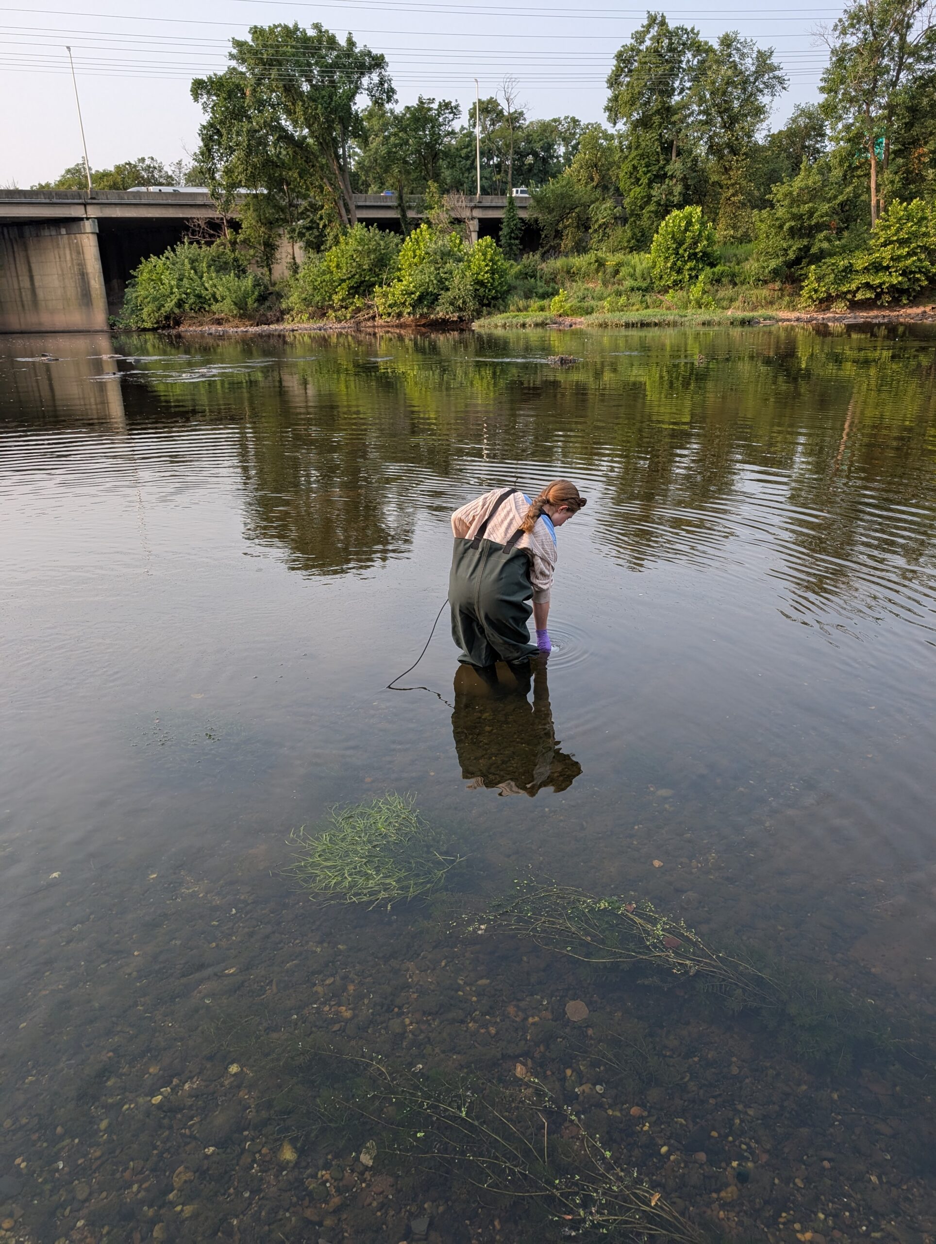
Ashley wears gloves while collecting a sample at Riverside Park to prevent contamination and keep herself safe. Photo credit: Rose Lawless.
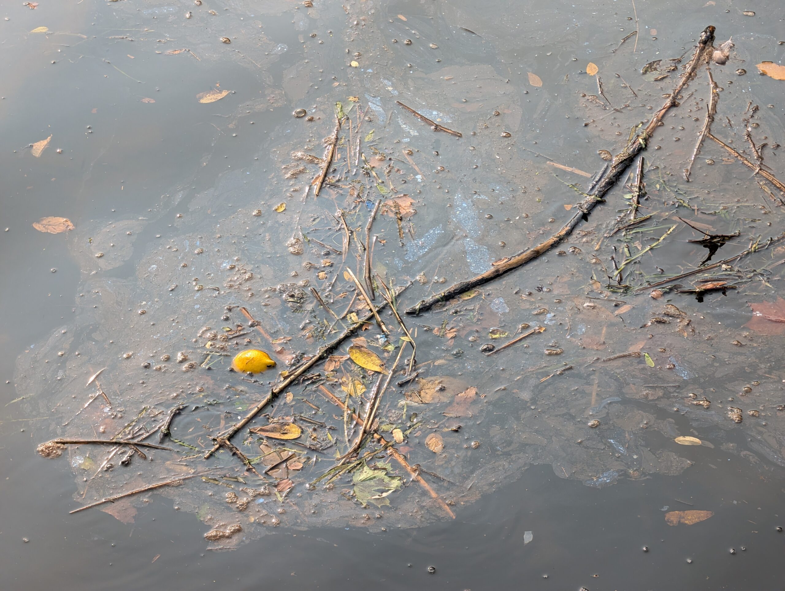
Debris and oily film float atop stagnant water in New Brunswick. Photo credit: Rose Lawless.
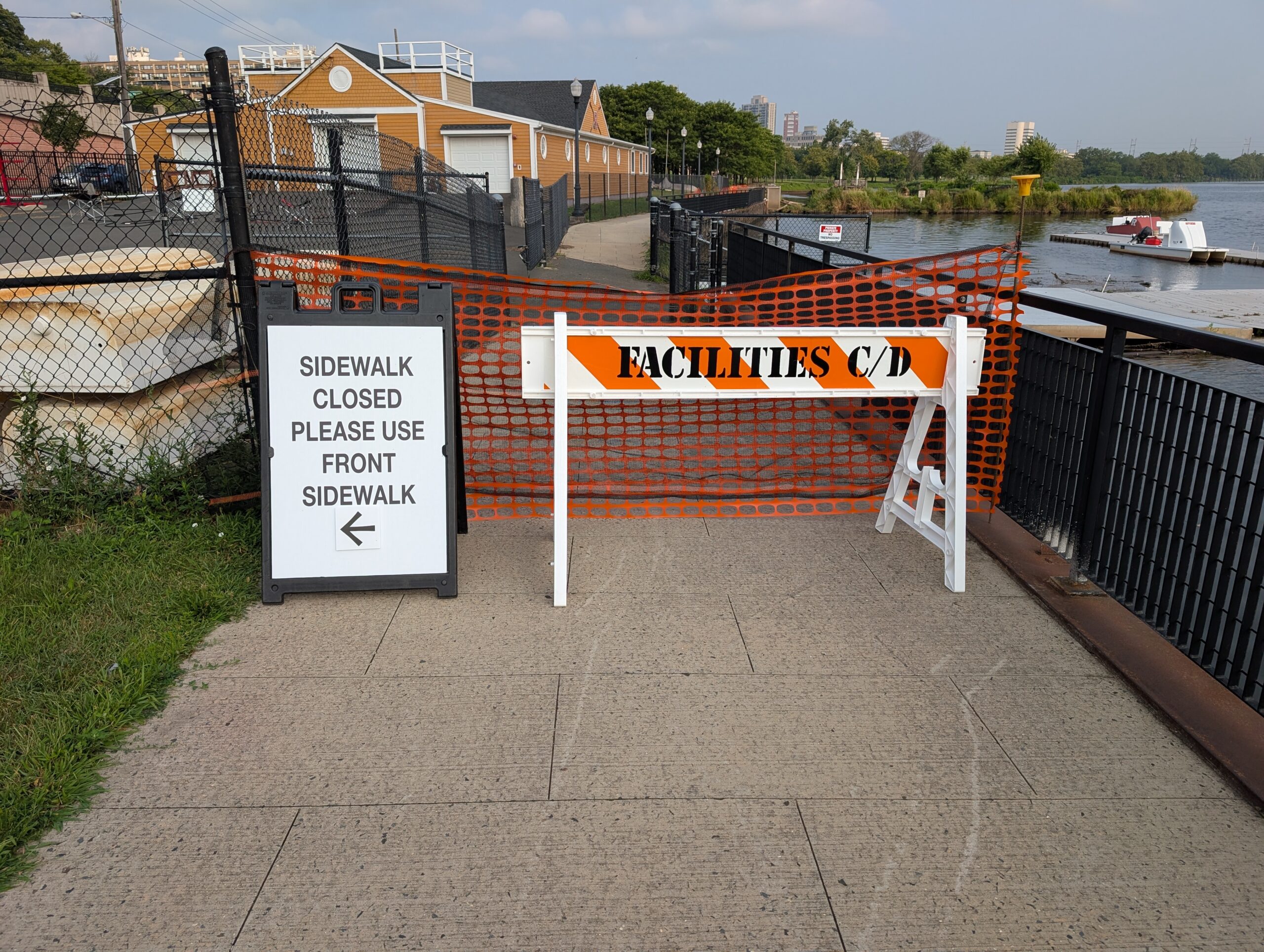
Blockades at Rutgers Boat House forced volunteers to move the sampling location for New Brunswick this week. Photo credit: Rose Lawless.
Art’s volunteer spirit compels him to pick up litter in Edison. Photo credit: Rose Lawless.
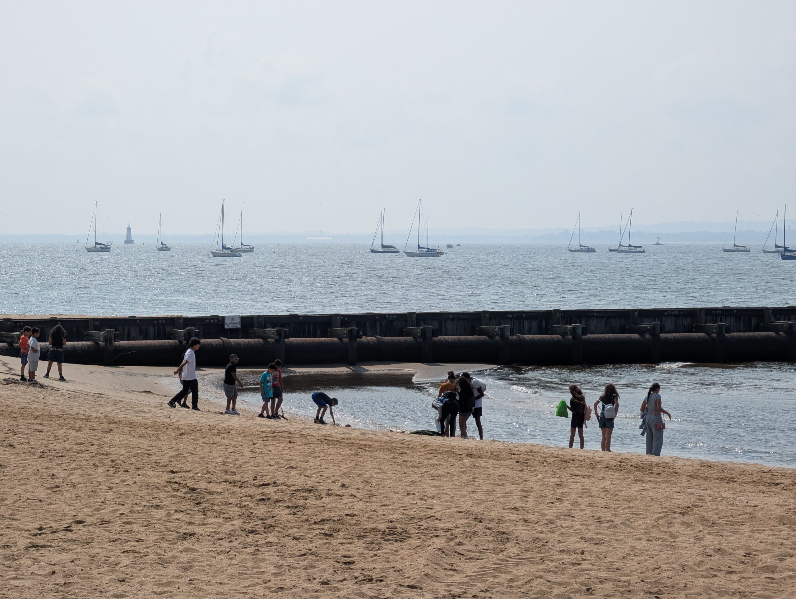
Families recreate on the shore of the Raritan River in Perth Amboy and watch the boats. Photo credit: Rose Lawless.
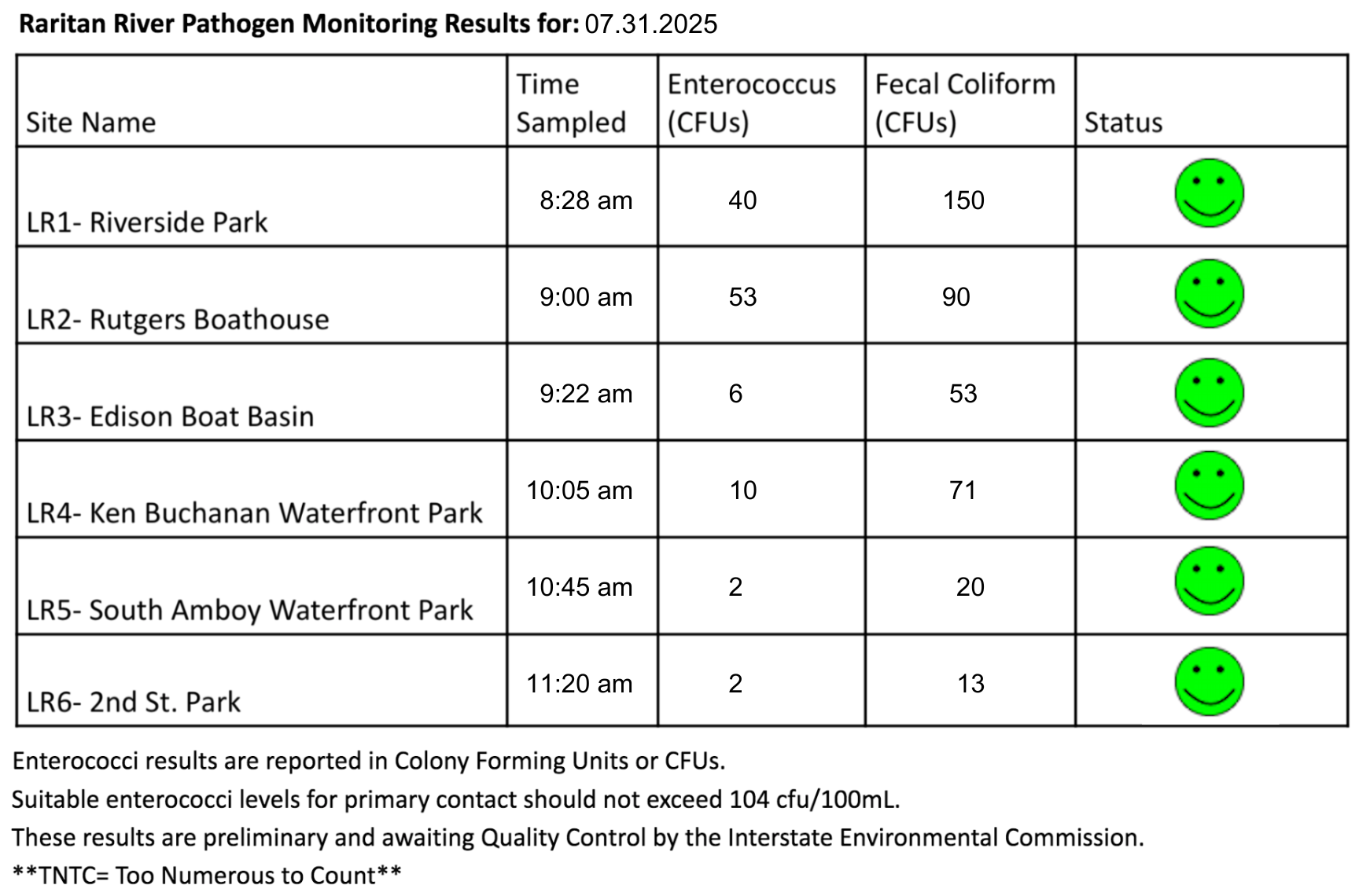
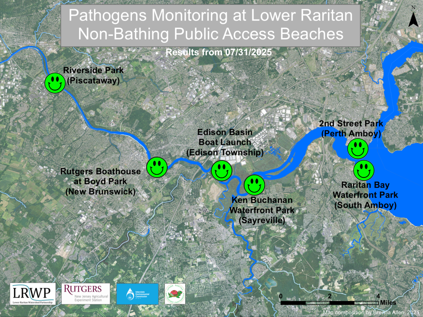
The last pathogen monitoring session for the month took place on July 31st. Each week during the summer, from May to October, the Lower Raritan Watershed Partnership and Rutgers Cooperative Extension of Middlesex County run a volunteer-based monitoring program along the Raritan River. We collect water quality samples at six non-bathing public access beach sites, provide our samples to the Interstate Environmental Commission for analysis in their laboratory, and report the results to the public. Our mission is to share this data with the community and partners to ensure the safe use of the Raritan river for all.
Our lab results for water quality samples taken on Thursday, July 31, 2025 show Enterococcus bacteria levels exceeding the EPA federal water quality standard of 104 cfu/100mL at none of our monitoring sites this week. Problem sites would be indicated by red frowns on the map and chart. Green smiles on the chart and map indicate the sites with bacteria levels safe for recreation, and include the following: Riverside Park (Piscataway), Rutgers Boat House (New Brunswick), Edison Boat Launch (Edison Township), Ken Buchanan Waterfront Park (Sayreville), Raritan Bay Waterfront Park (South Amboy), and 2nd Street Park (Perth Amboy).
While we are thrilled to see such great results along the Lower Raritan, we want to advise the public that our watershed experienced heavy rain almost immediately after our testing period on Thursday morning. Heavy rainfall tends to wash pollutants into the river. Therefore, we suspect at least some of our sites would fail our test if we were to repeat the sampling session this morning. Please take the following table and map with a grain of salt, and enjoy your weekend!
Pathogens/Enterococci levels are used as indicators of the possible presence of disease-causing bacteria in recreational waters. Such pathogens may pose health risks to people coming in primary contact with the water (touching) through recreational activities like fishing, kayaking or swimming in a water body. Possible sources of bacteria include Combined Sewer Overflows (CSOs), improperly functioning wastewater treatment plants, stormwater runoff, leaking septic systems, animal carcasses, and runoff from manure storage areas.
Our goal in reporting these results is to give residents a better understanding of the potential health risks related to primary contact during water-based recreation. If you are planning on recreating on the Raritan this weekend, make sure to stay safe and wash up after any activities!
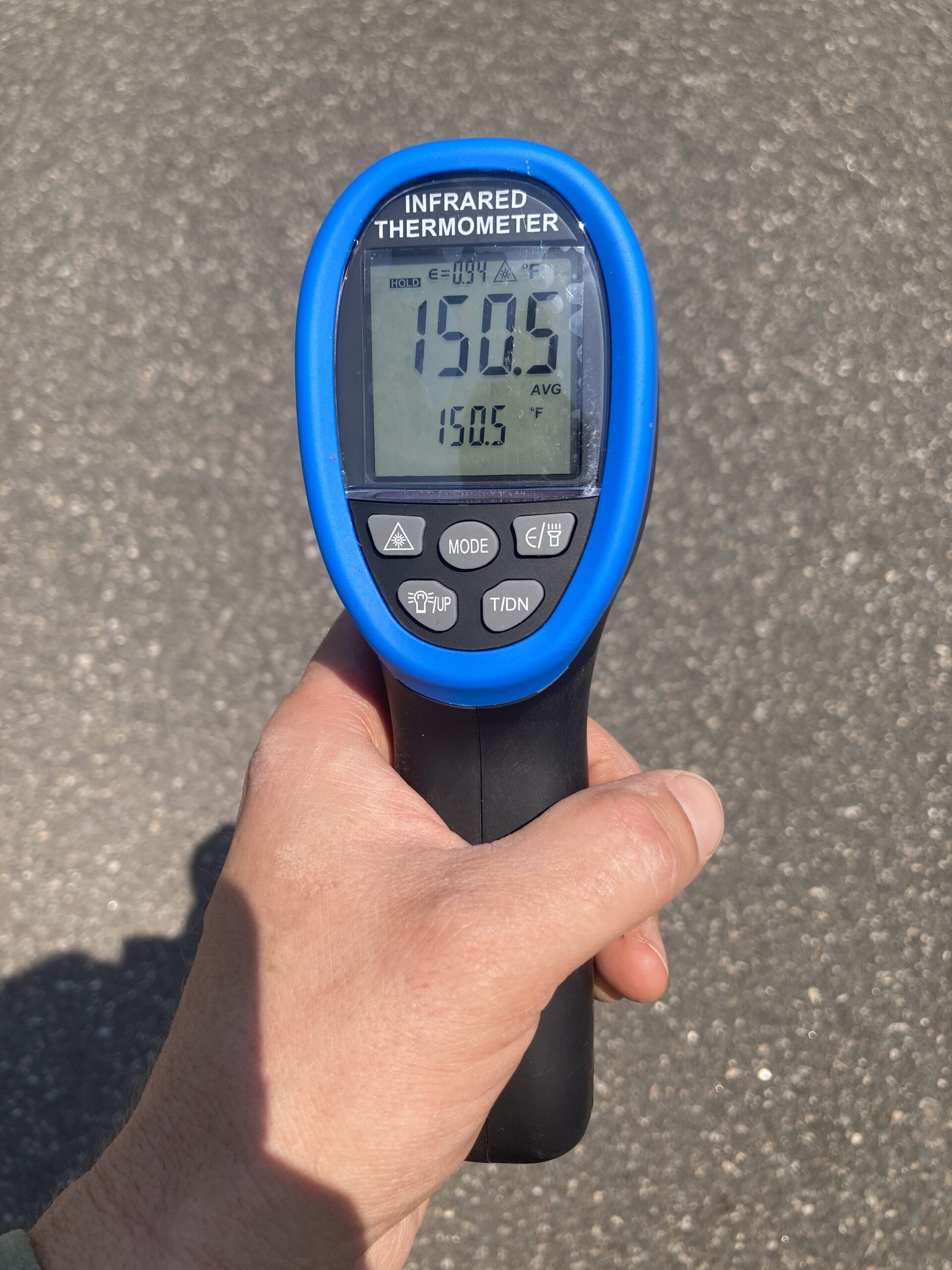
We found surface temperatures of more than 150 degrees Fahrenheit on the asphalt parking lot in New Brunswick. Please be careful this summer. Drink water, stay in the shade, and advocate for our municipalities to use cooler, more permeable surfaces in our parks and neighborhoods. Photo credit: — J.M. Meyer.
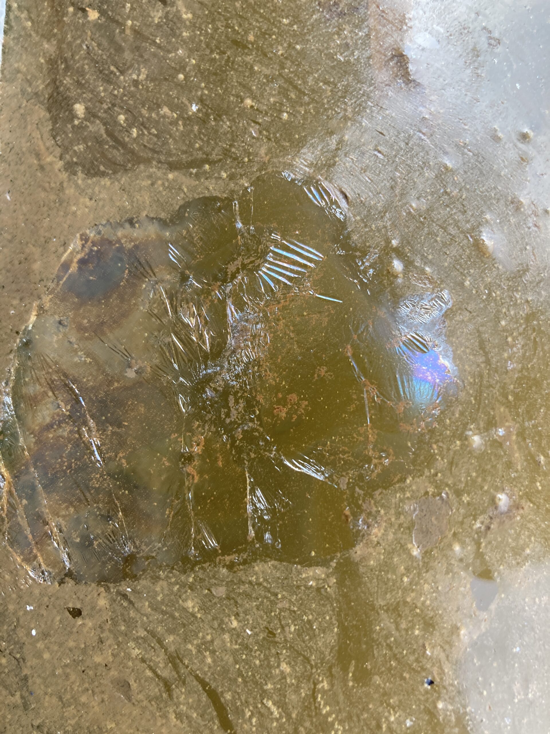
What’s in your water? In Sayreville, Edison Boat Basin, and New Brunswick we often find shiny pieces of film with a crackly texture. Some of our colleagues in the New York City area have suggested that this substance is ‘coal tar,’ a hazardous waste often produced when refining coal. But we would like more information! Have you seen anything strange in the Raritan River? Please contact us and let us know. Photo credit — J.M. Meyer.
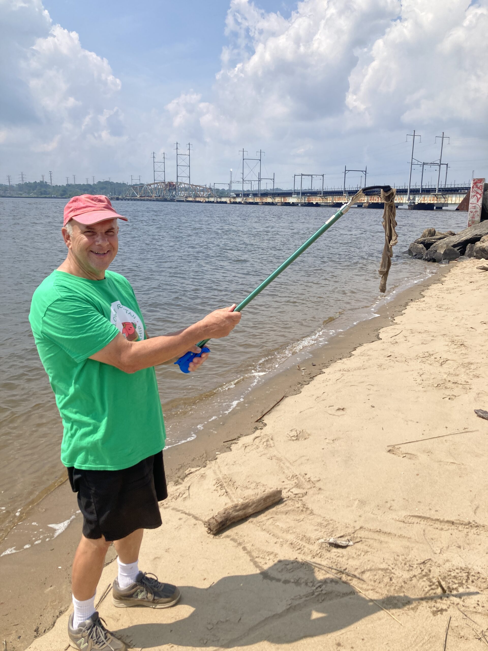
As we move through the monitoring sites, we always try to pick up the litter we stumble across. In this photo, Art courageously removes a sanitary cloth from the waters along Perth Amboy. Photo credit: — J.M. Meyer.
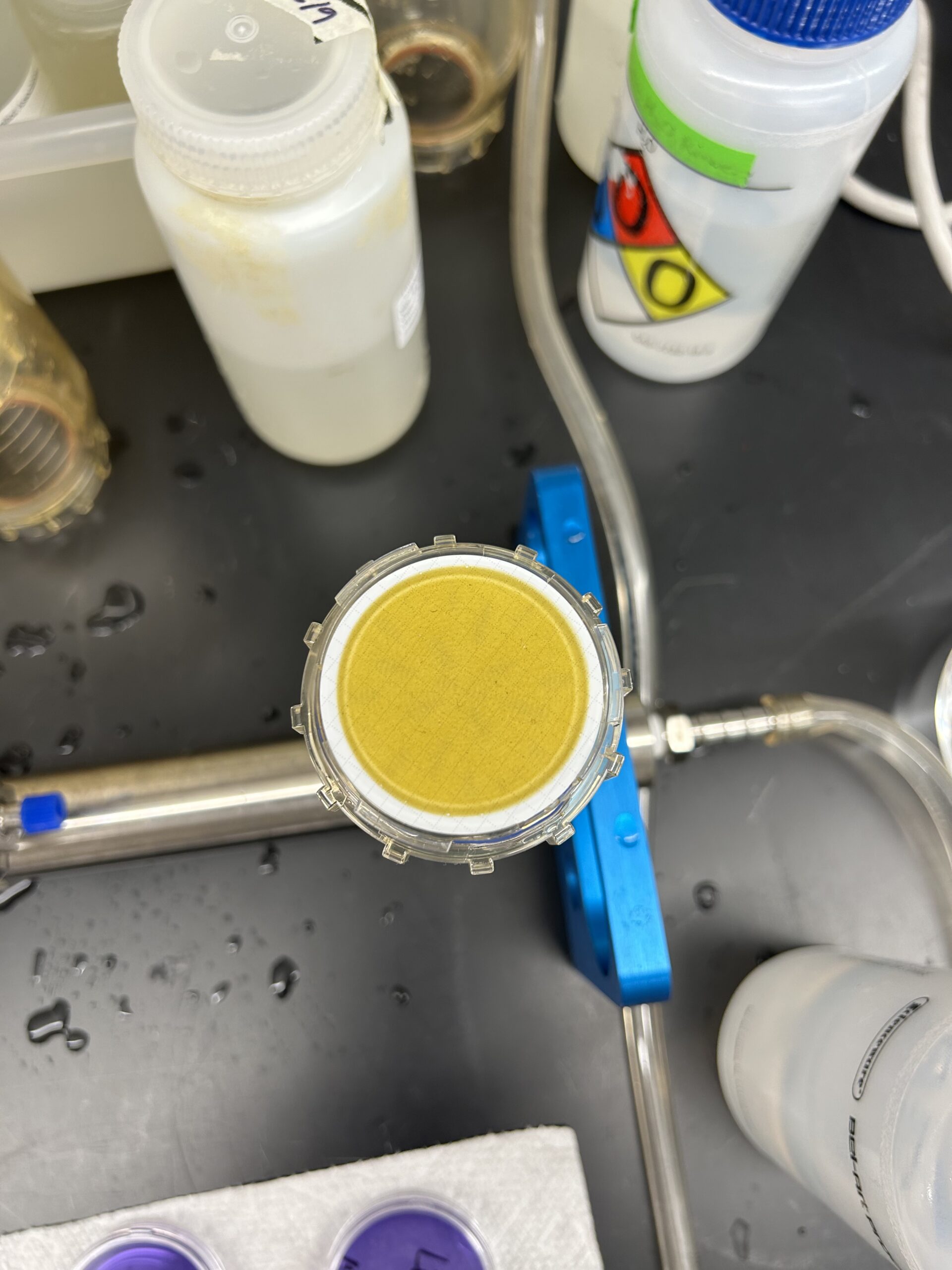
In South Amboy, our testers may have stepped into an active algae bloom. We found the highest concentrations of chlorophyl of the season, with a reading of over 41 Chlorophyll-a Relative Fluorescence Units (RFU). Chlorophyll-a RFU is a measurement used to quantify chlorophyll-a, a pigment found in algae and plants, based on the intensity of fluorescence emitted when the pigment is excited by light. In our lab analysis, our filtration process confirmed the finding. We’ll continue to monitor the water quality at South Amboy and elsewhere. Photo credit: — Ruby Alcorn.
The LRWP and SEWA volunteers went out to the litter trap in the Green Brook on Saturday, July 26th, 2025, to conduct a litter tally. Huge thanks to our SEWA International Central Jersey youth partners! Thanks to their efforts, we’ll have much better data on how the litter trap keeps our watershed clean. Learn more about the litter trap initiative here. And learn more about the LRWP’s litter tally project with SEWA here. Below, you’ll find Sewa’s Nilesh Bhat describing the litter we picked up and conditions surrounding the litter trap.
Blog post by Nilesh Bhat
On July 26th, Sewa leads checked on the litter trap for the 6th week. The litter trap only collected a few pieces of Styrofoam and some plastic. This was much less compared to other weeks. We moved on to picking up litter that we could see outside the trap. Here, we found a lot of plastic bags, plastic bottles, and other such litter. We also found a discarded appliance that we theorized to be either a wax melter or a humidifier. We also planted some seeds by the support rods holding the litter trap. This was in hopes that the roots could stabilize the ground and mitigate erosion during storms. We had put bug spray on as always, but we were swarmed with mosquitoes regardless. This resulted in one of the leads having a minor allergic reaction. The mosquitoes might have been higher in number this week due to high temperatures exceeding 100ºF and recent storms increasing water levels. It was an interesting week, and we will continue to monitor the trap.
The second-to-last pathogen monitoring session for the month took place on July 25. Each week during the summer, from May to October, the Lower Raritan Watershed Partnership and Rutgers Cooperative Extension of Middlesex County run a volunteer-based monitoring program along the Raritan River. We collect water quality samples at six non-bathing public access beach sites, provide our samples to the Interstate Environmental Commission for analysis in their laboratory, and report the results to the public. Our mission is to share this data with the community and partners to ensure the safe use of the Raritan river for all.
Our lab results for water quality samples taken on Thursday, July 24, 2025 show Enterococcus bacteria levels exceeding the EPA federal water quality standard of 104 cfu/100mL at two of our monitoring sites this week. Problem sites are indicated by red frowns on the map and chart which includes: Riverside Park (Piscataway) and 2nd St. Park (Perth Amboy). Green smiles on the chart and map indicate the sites with bacteria levels safe for recreation, and include the following: Rutgers Boat House (New Brunswick), Edison Boat Launch (Edison Township), Ken Buchanan Waterfront Park (Sayreville), and Raritan Bay Waterfront Park (South Amboy).
Pathogens/Enterococci levels are used as indicators of the possible presence of disease-causing bacteria in recreational waters. Such pathogens may pose health risks to people coming in primary contact with the water (touching) through recreational activities like fishing, kayaking or swimming in a water body. Possible sources of bacteria include Combined Sewer Overflows (CSOs), improperly functioning wastewater treatment plants, stormwater runoff, leaking septic systems, animal carcasses, and runoff from manure storage areas.
Our goal in reporting these results is to give residents a better understanding of the potential health risks related to primary contact during water-based recreation. If you are planning on recreating on the Raritan this weekend, make sure to stay safe and wash up after any activities!
The sonde helps us evaluate the water quality at Riverside Park in Piscataway. The water looks lovely, but unfortunately this site consistently performs the worst in our water quality tests. Please use caution if you enter the Raritan River in Piscataway. Photo credit — Christina Best.
Christina braves the oft polluted waters of Piscataway to gather data. As is usually the case, Piscataway once again proved the dirtiest of our six sites. — Photo credit: Karen Alvarado.
Local fishermen Salem and Levi update John on local happenings at the New Brunswick boat ramp. — Photo credit: Christina Best.
Ashley records the results from the YSI. — Photo credit: Karen Alvarado.
Sanitary wipes, a common sight at Perth Amboy due to the Combined Sewer Overflow system, wave in the breeze. — Photo credit: Karen Alvarado.
The LRWP and SEWA volunteers went out to the litter trap in the Green Brook on Saturday, July 19th, 2025, to conduct a litter tally. Huge thanks to our SEWA International Central Jersey youth partners! Thanks to their efforts, we’ll have much better data on how the litter trap keeps our watershed clean. Learn more about the litter trap initiative here. And learn more about the LRWP’s litter tally project with SEWA here. Below, you’ll find Sewa’s Pravith Venkat describing the litter we picked up and conditions surrounding the litter trap.Tragically, a terrible storm tore through our area of study on July 14th. Almost 6.5 inches of rain fell in one hour. Scores of homes flooded up and down the brook, and at least two homes saw their foundations ripped out by the current. At least two people drowned when their car was washed off a bridge.
Blog post by Pravith Venkat.
This week’s cleanup at the Greenbook stream was heavily influenced by a recent flash flood, which caused a surge in water flow and significant changes to the litter trap’s effectiveness. While we recovered a large volume of debris, much of it had either escaped the trap or washed up on the banks. This highlights the powerful impact natural disasters can have on our cleanup efforts.
Trash Found Outside the Trap:
1 mattress
29 aluminum cans
1 food can
1 glove
1 glass bottle
3 plastic lids
1 battery
1 safety razor
1 paint sample container
1 plastic container
1 boot
1 white bucket
26 plastic bottles
About 50 plastic wrappers
Few pieces of styrofoam
1 water reservoir
1 green trash can
2 straws
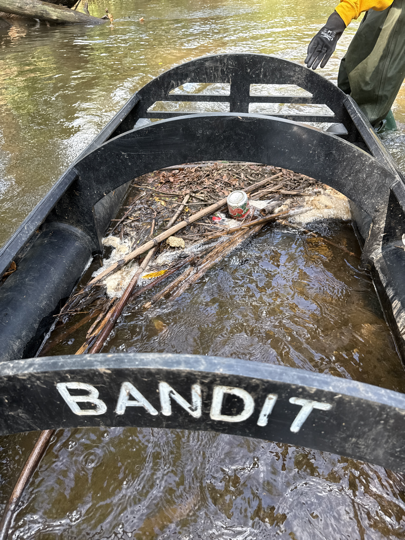
During the storm event, the Litter Bandit broke loose from the southern bank. It then swung into the current and broached the northern bank. Interestingly, when this happened, its large buoys trapped a substantial amount of trash that we were able to recover:
38 plastic bottles
1 plastic lid
1 cigarette case
3 plastic shot bottles
1 glass liquor bottle
4 aluminum cans
1 plastic bag
Lots of styrofoam
2 small soccer balls
1 flip flop
1 wooden piece
3 plastic wrappers
1 plastic gum container
1 paper cup
1 fishing lure
1 plastic cap
1 trashbag
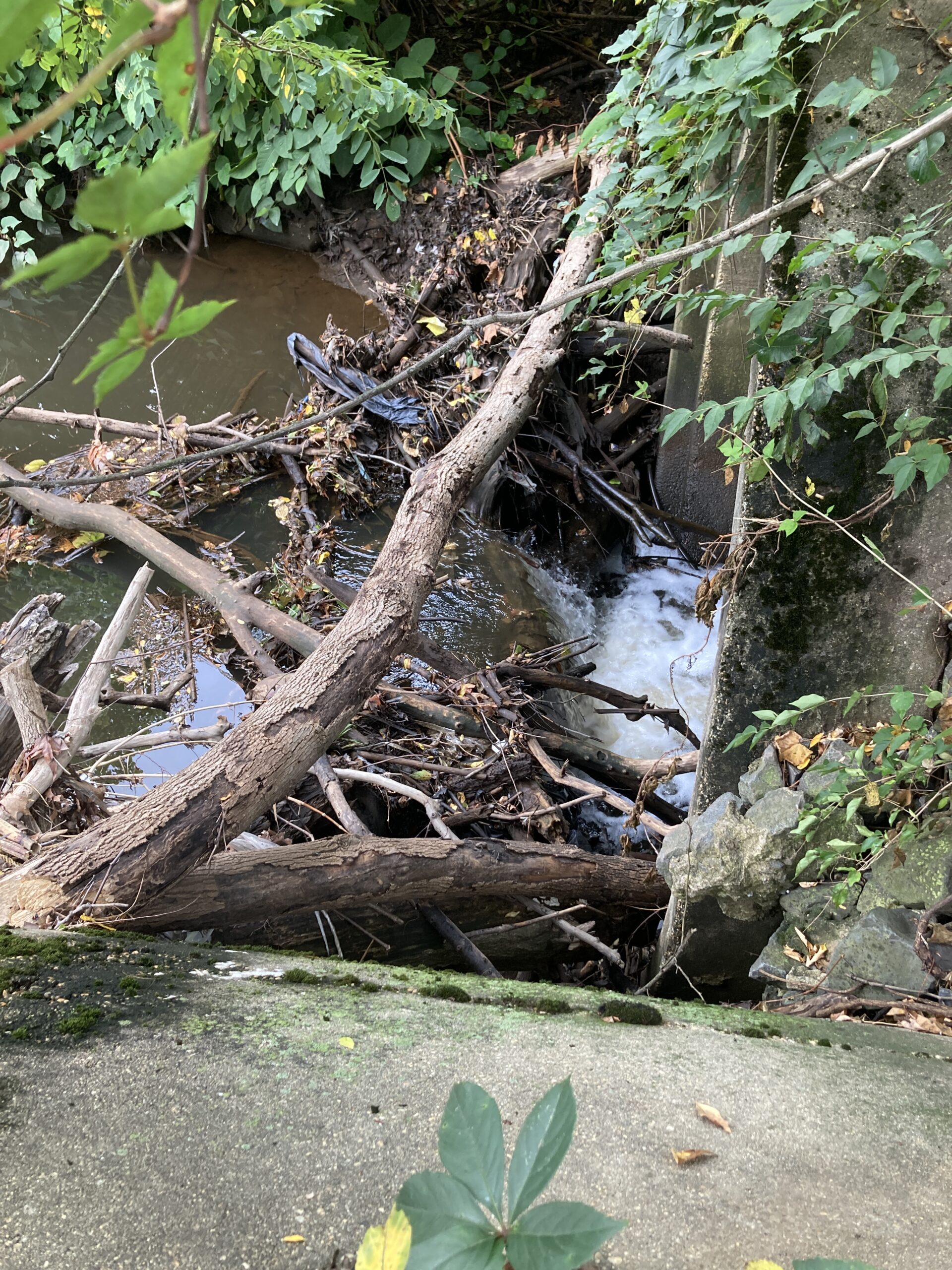
In this image, we can see how the buoys from the litter trap held tremendous amounts of debris against the northern bank after it detached from the southern bank. Photo credit: –Aasmi Bora.
After the storm, the Dunellen Department of Public Works reattached the Litter Bandit to the southern embankment.
Other observations:
The southern bank exhibited only minimal plant life in the area where the Litter Bandit had been attached, whereas the northern bank had a tremendous amount of riparian vegetation. The vegetation on the northern bank may have saved the litter trap from detaching from both banks.
The roots of two dead as tree roots still support the bank behind the trap, but they are deteriorating. Without these roots, the erosion from the storm could have been much more severe.
We saw many examples of ash trees destroyed by the Emerald Ash Borer beetle. While the Emerald Ash Borer beetle is usually thought of us a pest that destroy urban and suburban ash trees, its worst effects may be the damage done to its native habitat of stream and river banks.
Due to a strong odor, we believe a dead animal is trapped among the woody debris washed against the northern bank.
This week highlighted one of the biggest challenges with installing litter traps in streams: How can we prepare a litter trap to handle extreme weather events? Once the water level rose too high, the current became too strong, causing debris to escape the trap. Then, the water pressure on the stream bank and the buoys caused the attachment to fail on the southern bank.
We are also noticing more signs of ecosystem damage, such as the presence of the Emerald Ash Borer beetle, which destroys the ash trees that hold together stream banks.
Going forward, we will continue to evaluate the trap’s structure and location. This could mean relocating it, or tying the rope to a stronger tree to improve stability. Our goal is to stop litter from reaching the river. To do that, we need a trap that can handle both normal water flow and extreme weather.