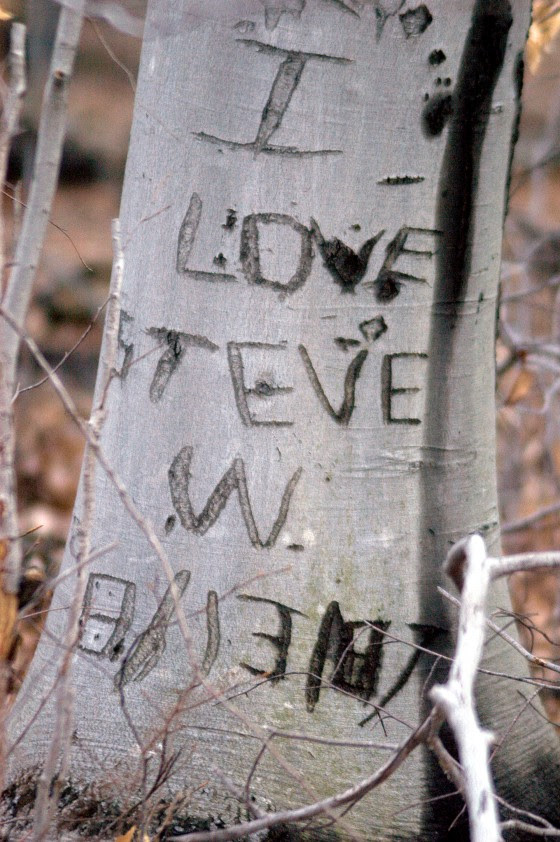
Message from the early nineteenth century remains in place. Hand carved declaration memorializing the men involved in the construction of the bridge. No so different in style and material than petroglyphs from paleo times. Words replace symbols to convey a message deemed important to future travelers.
The stone plaque set in the fieldstone bridge over Cat Tail Brook is crudely chiseled with the date 1825 along with the name of the mason and men who directed its construction.
The graves of the early settlers preserved in a small patch of land are marked with red shale stones, some with hand carved epitaph’s, other small, weathered stones barely decipherable, some messages completely eroded.
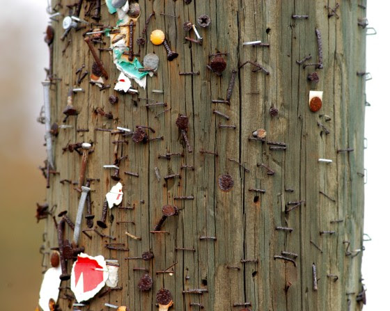
A block of shale rests in the river with the inscription J N Stout along with the Roman numeral XVI. Well into the twentieth century, property lines were represented by rocks or trees with slash marks.
The need to communicate is an innate human behavior, messages scribed on whatever canvas is available, whether it be scribbled on a napkin, roadside billboard, or graffiti on the side of a building. From the Chauvet Pont d’ arc caves of France and their well-preserved pictographs, to the Parsippany petroglyphs in north Jersey, each generation of humans, worldwide, expressed themselves in the most rudimentary ways, using whatever medium was on hand.
My interest is in the paleo or pre-colonial people who lived in our area whose rationale for leaving signs and messages is no different than those seen today. Messages that were the precursor of books, told stories of the hunt or other rituals in pictographs, dendroglyphs and petroglyphs. Pictographs are paintings placed in a protected area, dendroglyphs were images carved into a tree who bark had been partially stripped, petroglyphs were figures carved or etched into stone, usually in the open for travelers to see.
Just as the local Indians used trees to convey messages along travel paths, the desire for humans to communicate is as strong today as it was when paleo people walked the North and South Branch of the Raritan river. The search for petroglyphs is not confined to the realm of certified experts.
In the book, “Rock Art of Eastern North America”, the author notes the scarcity of primitive art in the eastern woodlands versus the numerous examples in the western states, primarily due to climate. As trees were the dominant canvasses of the woodlands, trees carved with dendroglyphs are not likely to be found. The rock strewn Sourland mountains would be a prime location for glyphs, while in the glacial scoured highlands of northern NJ, petroglyphs been authenticated.
An example noted in the book explains dendroglyphs were located on well-travelled trails, river crossings and prominences. The topography of the land was also a factor as it restricted or directed travel around obstacles, along rivers or mountain trails. Humans as well as wildlife seek out paths of least resistance as well as places which provide a view. What traveler has not succumbed to the temptation to climb a huge boulder alongside a hiking trail? In paleo times that rock was a safe place to camp, seek refuge from a wolf, or ambush a deer. Some successful hunter might leave a mark to commemorate his luck.
Without having read or heard of such a ritual, I would leave a coin where a deer fell to my arrow. I don’t know why I did that; no one will ever find that coin. Maybe a lingering primal behavior acted out to ensure my clan’s survival by telling another hunter, that the location was a good place to hunt.
The South and North branch and Raritan rivers are prime places to look for petroglyphs on the shale cliffs. You are not likely to discover one, but certainly these would be the places to look. Indian artifacts abound and stories of local collectors are many. The cliffs protruding from the flood plain attracted passersby to the precipice, to see what they might see. We can only imagine a glyph carved into a nearby tree by the Unami clan, represented by the image of a turtle. Perhaps it marked territory, a place to camp or images of a turtle holding a tomahawk to signify a war party, as mentioned in the Rock Art book. Chance of finding artifacts at these outcroppings are greater than finding stone carvings.
Knowing that our rivers were the highways of pre-colonial times, I cannot resist re-examining one particular, smooth red shale cliff, for the remains of an eroded petroglyph. That rare, smooth red shale canvas must have served as a primitive billboard with images of fish and deer taken by the Unami clan. I can’t find a sign, but I keep on looking at that cliff as if the imagined carvings were somehow transcribed to mental images perceived only by kindred spirits who traveled the same watery path.
I keep staring at this smooth cliff face along the river, hoping imagination will be the key to discovering an actual petroglyph. There is no way an early traveler could resist leaving a message on that unusual, smooth red shale tablet!
Further proof of the unbroken, innate need for humans to communicate along travel routes. Just as in paleo times a message board would be updated with symbols perhaps to show the results of a raiding party or successful hunt.
Author Joe Mish has been running wild in New Jersey since childhood when he found ways to escape his mother’s watchful eyes. He continues to trek the swamps, rivers and thickets seeking to share, with the residents and visitors, all of the state’s natural beauty hidden within full view. To read more of his writing and view more of his gorgeous photographs visit Winter Bear Rising, his wordpress blog. Joe’s series “Nature on the Raritan, Hidden in Plain View” runs monthly as part of the LRWP “Voices of the Watershed” series. Writing and photos used with permission from the author. Contact jjmish57@msn.com.
By LRWP Board President Heather Fenyk, Ph.D., AICP/PP
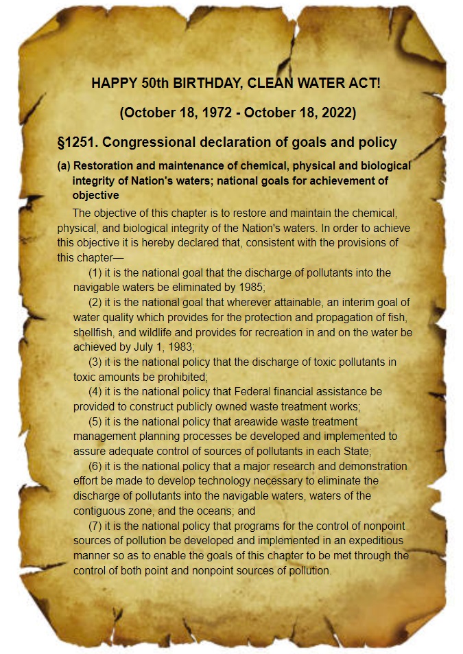
Today, October 18, 2022, marks the 50th anniversary of the Clean Water Act (CWA). To be sure, we owe a debt of gratitude to the shapers of the 1972 CWA for creating a law that significantly stemmed the flow of noxious point source pollutants into the nation’s waters. While we celebrate the successes of this seminal legislation, it is important to acknowledge the still unmet mandate of the CWA to bring about drinkable, fishable, swimmable waters. Water pollution remains a profound problem, with more than forty-seven thousand US waters still impaired. This includes every single stream, brook and river in the Lower Raritan Watershed. The major source of pollution into waters US and globally? Non-point source runoff from farm fields and the hardscape surfaces of our developed landscapes.
The LRWP believes we must chart a new path to meet drinkable, fishable, swimmable goals in the next 50 years:
In terms of strategy, centering the health of watersheds in environmental policymaking is key to realizing healthy waters.
This strategy must include integrated watershed management approaches that: 1) minimize impacts of land uses and development on waterways (good stormwater management is a start, however it does not go far enough as preventive practice); 2) require wastewater and stormwater be managed as assets; and 3) center the hydrologic cycle and aquatic systems in maintaining and restoring habitat connectivity.
On October 22 the LRWP will host a clean-up of the South River floodplain to recognize the 10th anniversary of SuperStorm Sandy. Reflecting on the impact of this storm we recall the catastrophic failure of Middlesex County Utilities Authority’s centralized sewage treatment facility. Sandy-related failure of the MCUA facility resulted in direct point source discharge of hundreds of millions of raw, untreated sewage into our waters. Observing how MCUA continues to discharge treated sanitary sewage into the Raritan River gives us pause. A holistic watershed management approach views wastewater as an asset, with water reclamation and reuse closing the loop between water supply and wastewater disposal. Setting an agenda for clean water for the next 50 years we must prioritize these better ways to clean up our waterways while meeting other sustainability goals.
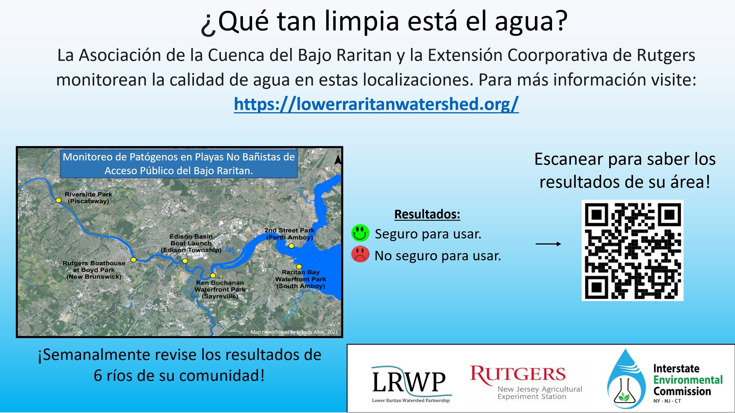
By LRWP Monitoring Outreach Coordinator Jocelyn Palomino
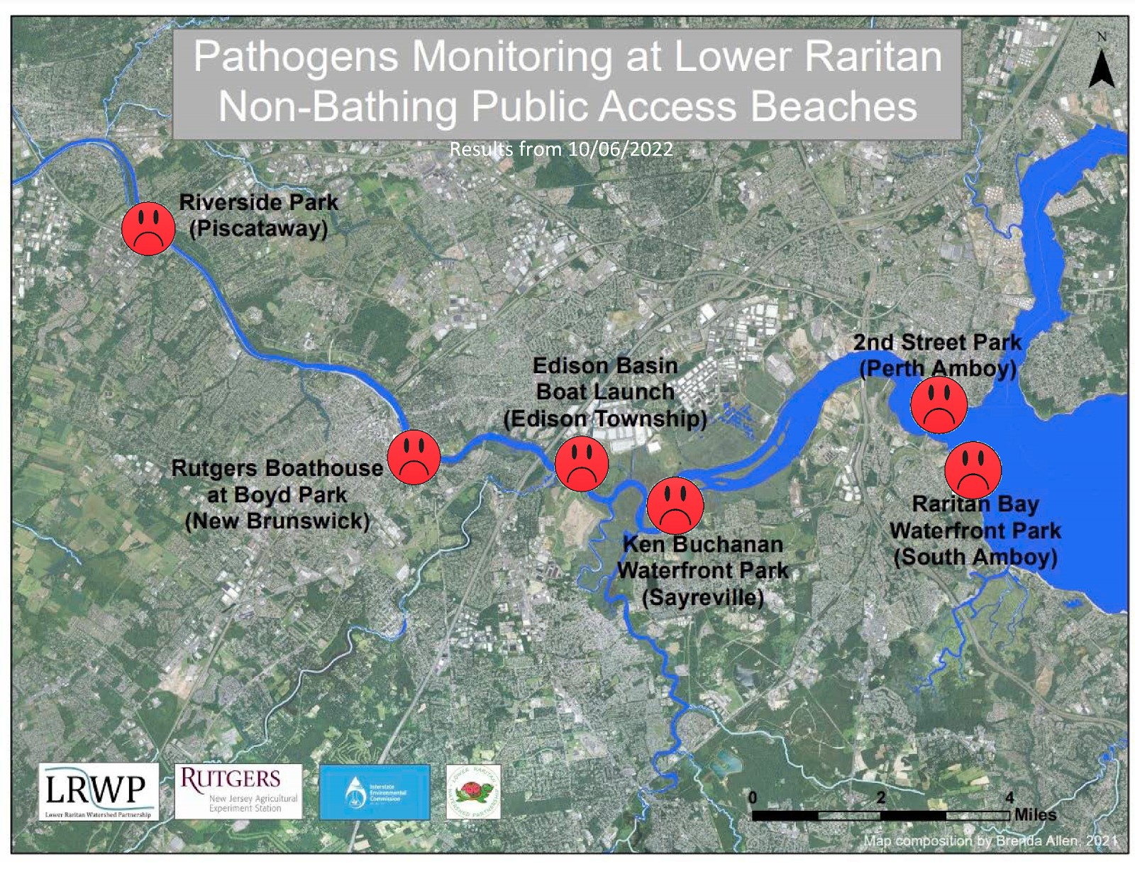
The Lower Raritan Watershed Partnership and Rutgers Cooperative Extension of Middlesex County run a volunteer pathogens monitoring program from May to September every Summer. On Thursdays we collect water quality samples at six (6) non-bathing public access beach sites along the Raritan River, provide our samples to the Interstate Environmental Commission for analysis in their laboratory, and report the results to the public on Friday afternoons. Our goal in reporting these results is to give area residents an understanding of potential health risks related to primary contact (touching) the water during water based recreation.
Our lab results for our final water quality sampling session of the season on October 6, 2022 indicate Enterococcus bacteria levels exceeding the EPA federal water quality standard of 104 cfu/100mL at ALL of our Lower Raritan sites. This is not surprising given the abundance of rainfall earlier in the week. We received as much as 4.5 inches of rain in some parts of the watershed from October 1-5. We know that the more rain that falls on the land, washing waste off impervious surfaces and into the waters, the higher the Enterococci pathogens counts in our water quality samples. And at our Perth Amboy Combined Sewer Overflow (CSO) site we observed point source sanitary waste flows directly into the River, with abundant pulverized toilet paper floating in the water.
Our problem sites for October 6, indicated by red frowns on the map and chart, include: Riverside Park (Piscataway), Rutgers Boathouse (New Brunswick), Edison Boat Ramp and Ken Buchanan Waterfront Park (Edison), South Amboy Waterfront Park (South Amboy), and 2nd Street Park (Perth Amboy).
Pathogens/Enterococci levels are used as indicators of the possible presence of disease-causing bacteria in recreational waters. Possible sources of bacteria include Combined Sewer Overflows (CSOs), improperly functioning wastewater treatment plants, stormwater runoff, leaking septic systems, animal carcasses, and runoff from manure storage areas. Such pathogens may pose health risks to people fishing and swimming in a water body. If you choose to recreate on the Raritan, please do so safely and be sure to wash thoroughly after all activities!
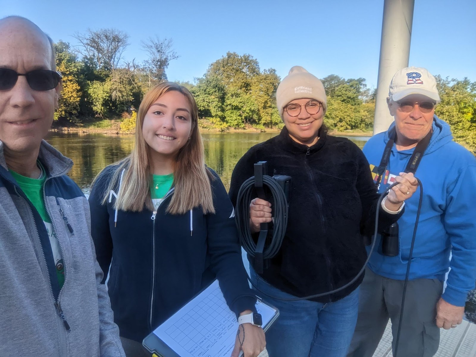
That’s a wrap for our Summer 2022 Pathogens Monitoring Program! Special thanks to our partners Michele Bakacs at Rutgers Cooperative Extension, Samantha Wilder and Evelyn Powers the Interstate Environmental Commission, and Nicole Fahrenfeld, Cristian Sanlatte, and Genevieve Ehasz with the Fahrenfeld Lab at Rutgers University. And extra special thanks to our amazing team of volunteers: Andrew Gehman, Frank Dahl, Julisa Collado, and Doreen Camardi.
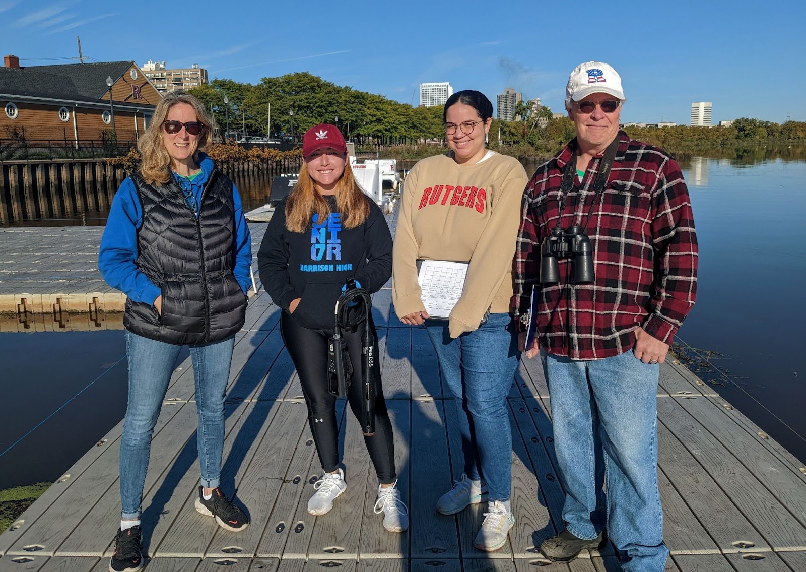
A great picture of the team at the Rutgers Boat Dock during our last monitoring run this season.
Pictured left to right: Heather Fenyk, Jocelyn Palomino, Julisa Collado and Frank Dahl.
Photo Credit: Andrew Gehman
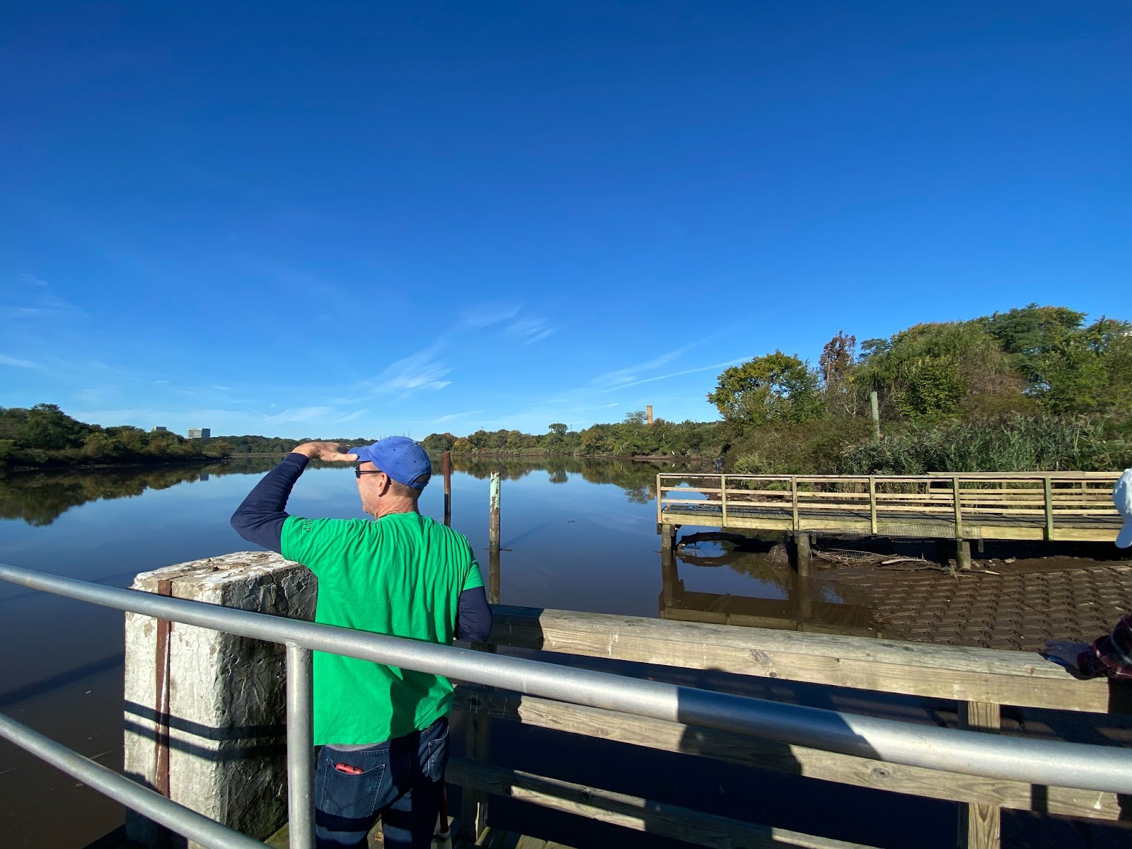
Andrew Gehman observes birds flying by at our Edison Site, Photo Credits: Jocelyn Palomino
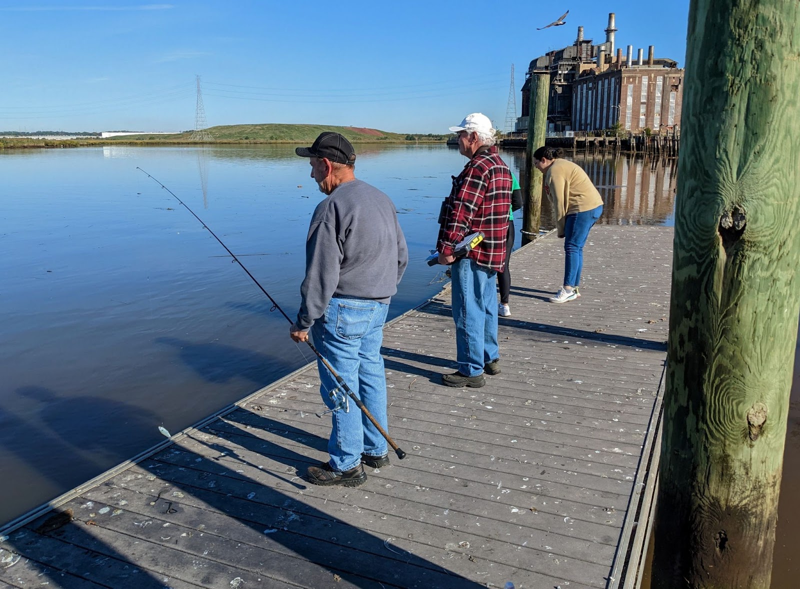
While we were sampling at the Ken Buchanan Waterfront Park, we shared the dock with a local man who had just caught a 27-inch striped bass, Photo Credits: Jocelyn Palomino
With an active discharge coming from the CSO at Perth Amboy’s 2nd St. Park, the water was filled with pulverized toilet paper along with an overwhelming odor after the heavy rainfall from the week, Photo Credits: Jocelyn Palomino
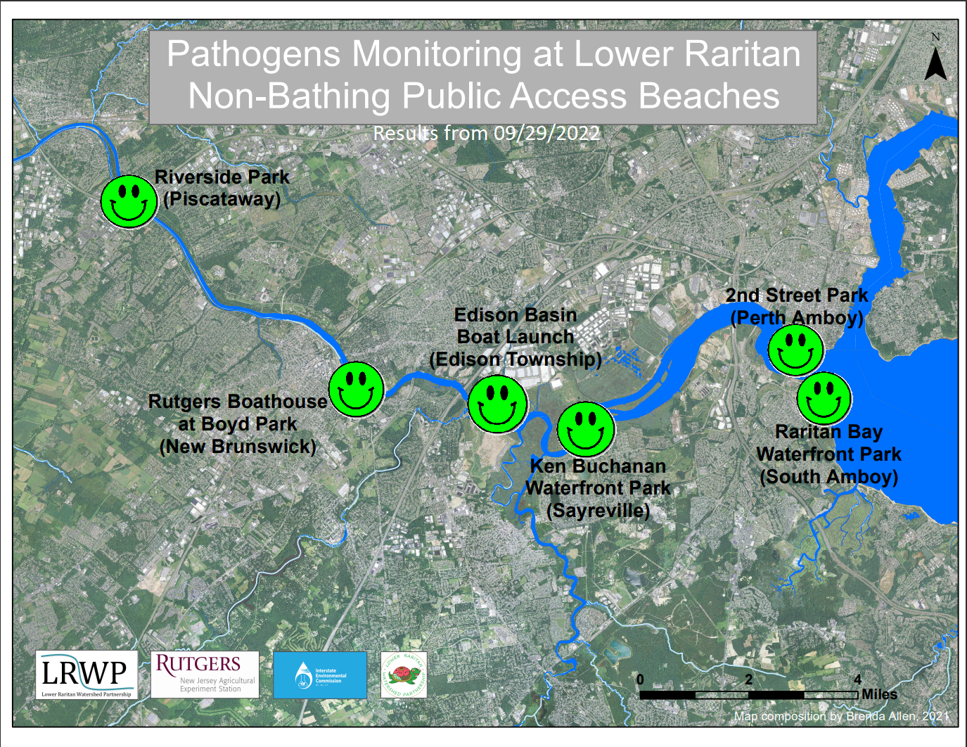
By LRWP Monitoring Outreach Coordinator Jocelyn Palomino
The Lower Raritan Watershed Partnership and Rutgers Cooperative Extension of Middlesex County run a volunteer pathogens monitoring program from May to September every Summer. On Thursdays we collect water quality samples at 6 non-bathing public access beach sites along the Raritan River, provide our samples to the Interstate Environmental Commission for analysis in their laboratory, and report the results to the public on Friday afternoons. Our goal in reporting these results is to give area residents an understanding of potential health risks related to primary contact (touching) the water during water based recreation.
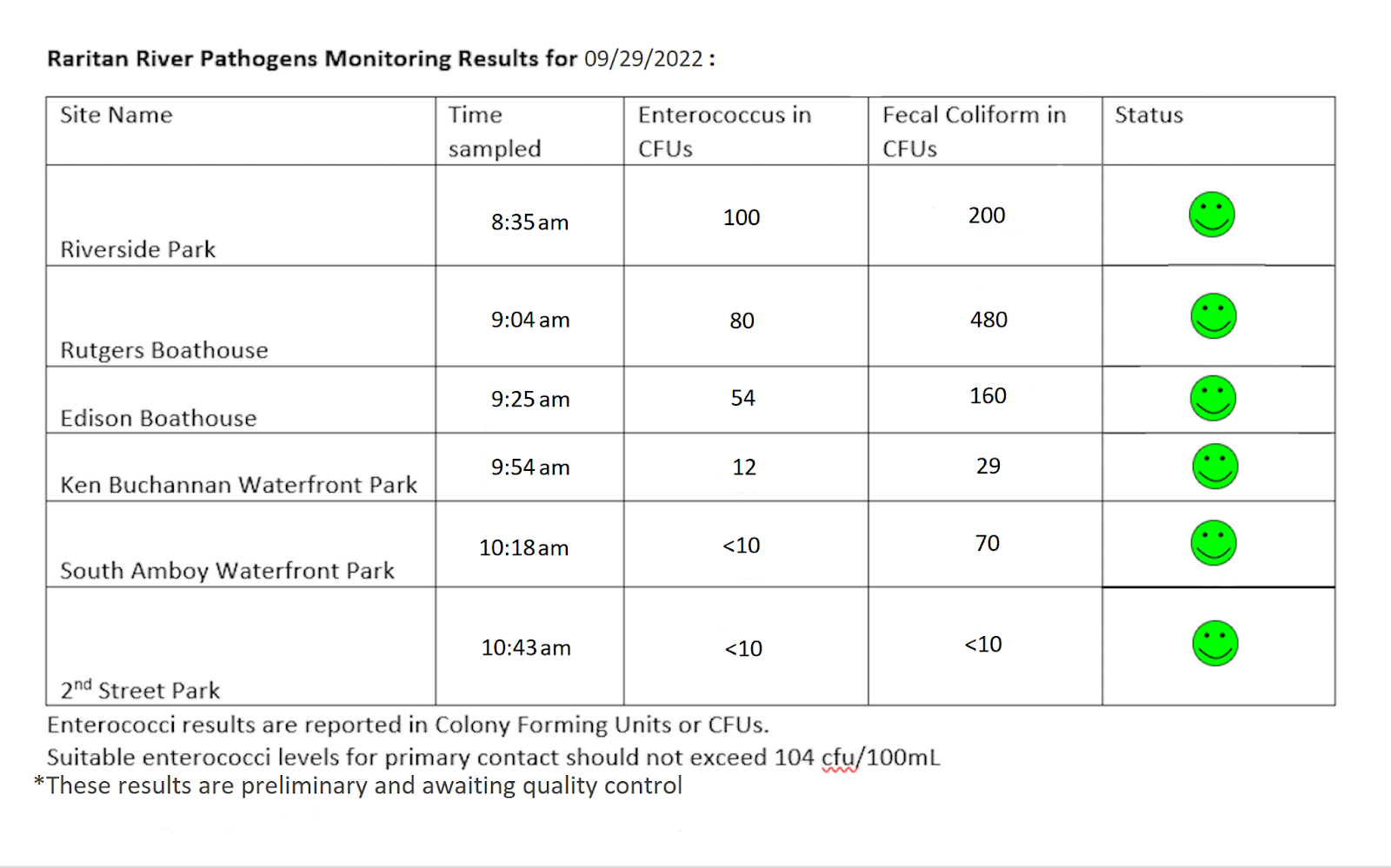
Our lab results for water quality samples taken on September 29, 2022 show that Enterococcus bacteria levels do not exceed the EPA federal water quality standard of 104 cfu/100mL at any of our sites this week! Problem sites are normally indicated by red frowns on the map and chart, but the green smiles represent sites with bacteria levels below the federal standard for recreation including: Riverside Park (Piscataway), Rutgers Boathouse (New Brunswick), Edison Boat Ramp and Ken Buchanan Waterfront Park (Edison), South Amboy Waterfront Park (South Amboy), and 2nd Street Park (Perth Amboy).
Pathogens/Enterococci levels are used as indicators of the possible presence of disease-causing bacteria in recreational waters. Possible sources of bacteria include Combined Sewer Overflows (CSOs), improperly functioning wastewater treatment plants, stormwater runoff, leaking septic systems, animal carcasses, and runoff from manure storage areas. Such pathogens may pose health risks to people fishing and swimming in a water body. Please note: disease causing pathogens may be present in local waters even if lab results indicate levels below state or federal thresholds. If you choose to recreate on the Raritan, be safe and wash thoroughly after all activities.
Our team for this week geared up for the chilly morning we had on Thursday, Photo Credit: Andrew Gehman
While at the Rutgers Boat House, we encountered some folks who were fishing recreationally and caught some big ones as we did our sampling, Photo Credits: Frank Dahl
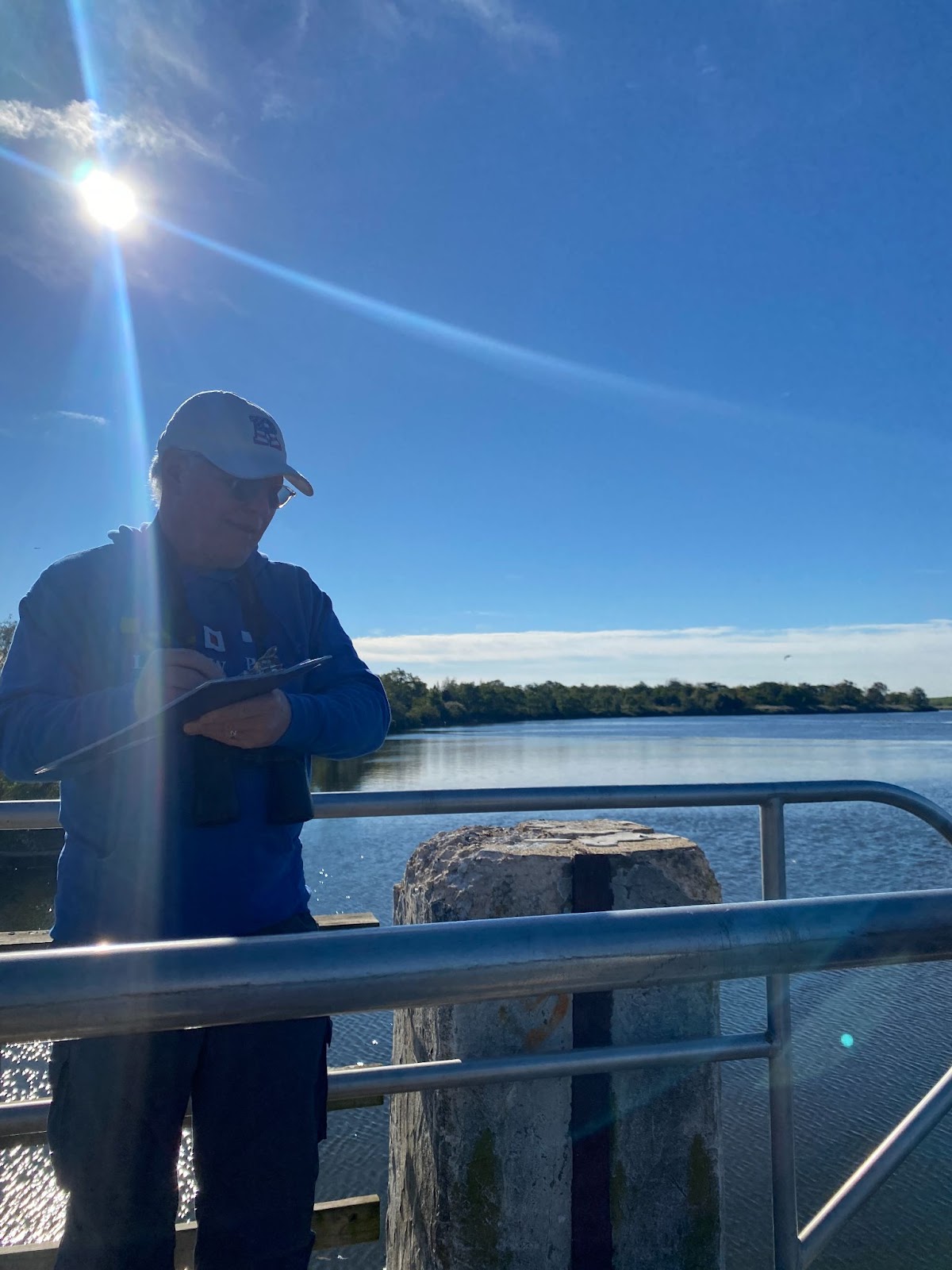
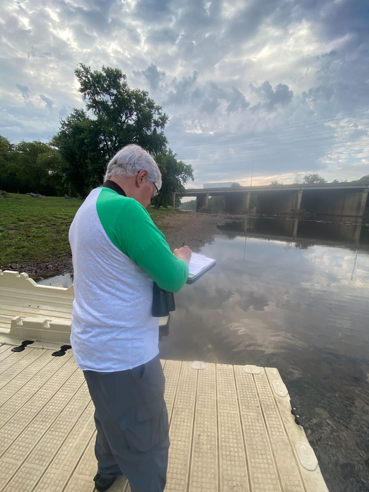
Volunteer Frank Dahl at the Edison Boat Basin completing a field observation datasheet to collect data on the environmental conditions and recreational activities at the time of sampling, Photo Credits: Jocelyn Palomino
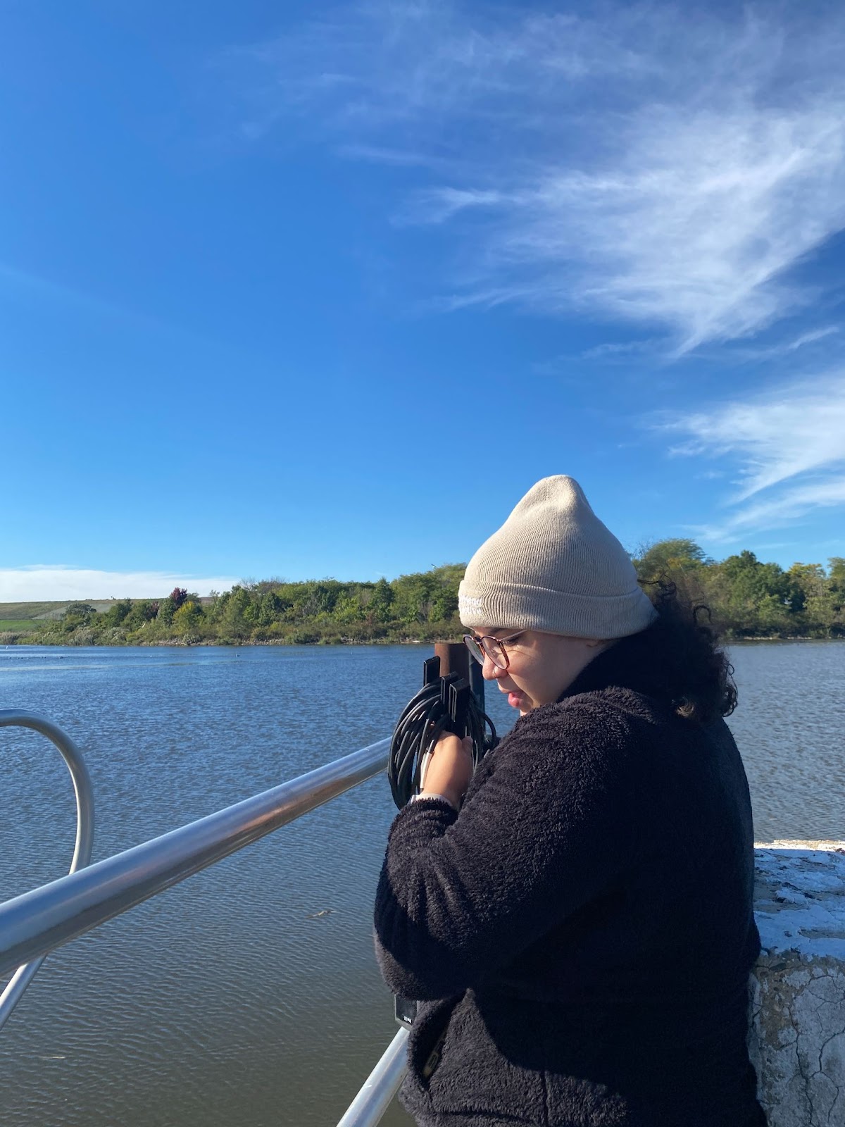
Julisa Collado took charge of using our monitoring equipment this week at our sampling sites, Photo Credits: Jocelyn Palomino
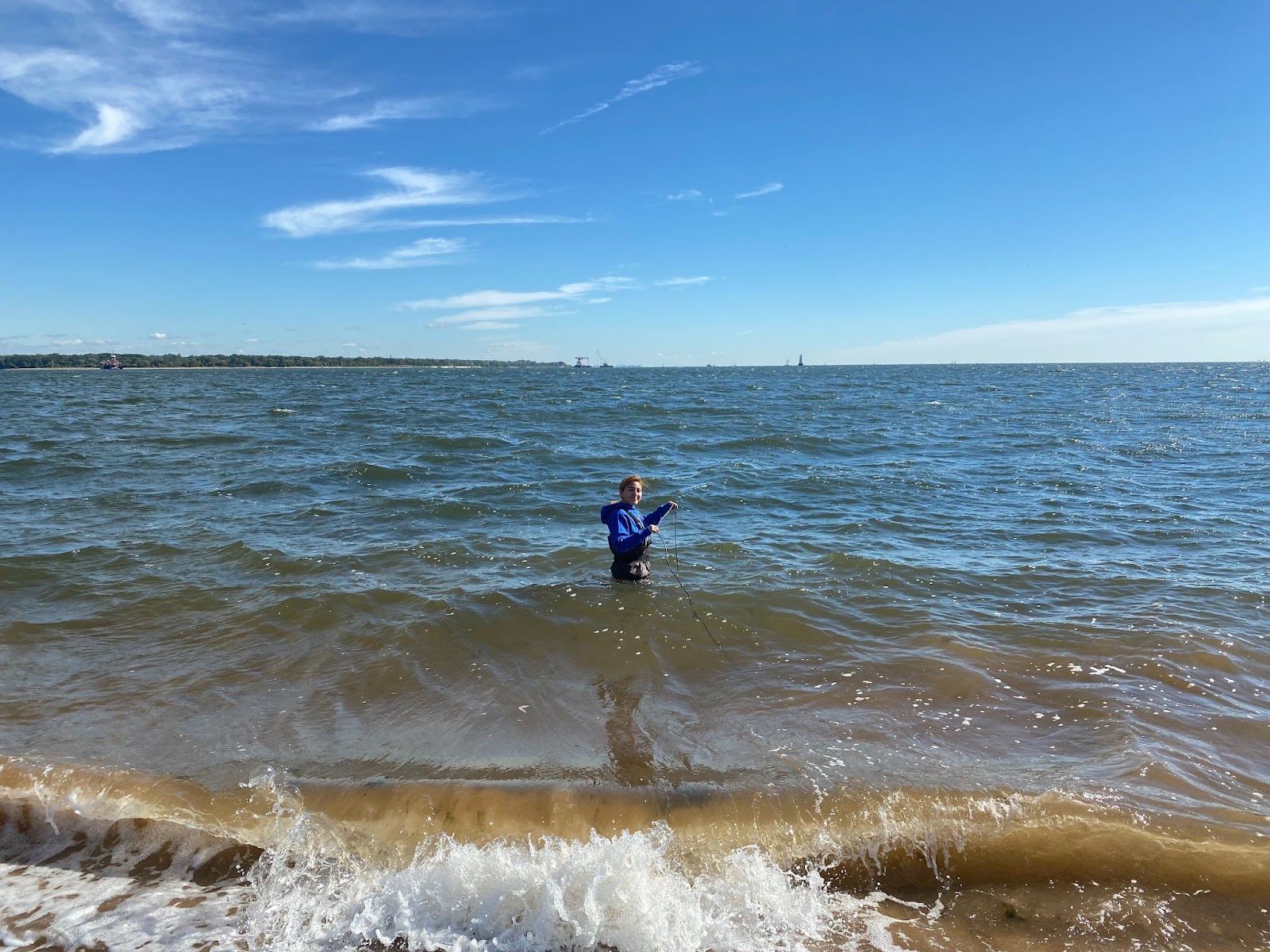
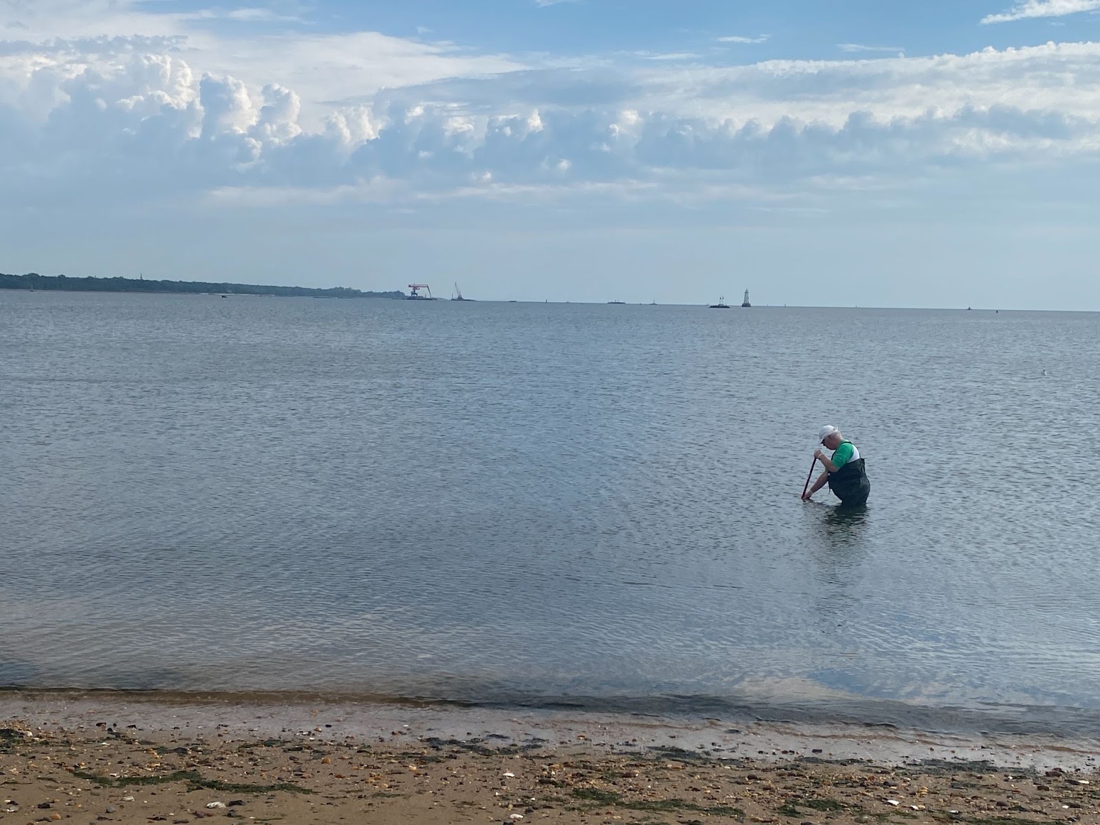
At our South Amboy site, Jocelyn had to endure some strong waves to reach our weekly sampling point, Photo Credits: Julisa Collado
By LRWP Monitoring Outreach Coordinator Jocelyn Palomino
The Lower Raritan Watershed Partnership and Rutgers Cooperative Extension of Middlesex County run a volunteer pathogens monitoring program from May to September every Summer. On Thursdays we collect water quality samples at 6 non-bathing public access beach sites along the Raritan River, provide our samples to the Interstate Environmental Commission for analysis in their laboratory, and report the results to the public on Friday afternoons. Our goal in reporting these results is to give area residents an understanding of potential health risks related to primary contact (touching) the water during water based recreation.
After receiving about 0.25 inches of rain on Wednesday, lab results for water quality samples taken on Thursday, September 22, 2022 show Enterococcus bacteria levels that exceed the EPA federal water quality standard of 104 cfu/100mL at our three most upstream sites. Problem sites are indicated by red frowns on the map and chart and include Riverside Park (Piscataway), Rutgers Boathouse (New Brunswick), and the Edison Boat Ramp (Edison). The green smiles represent sites with Enterococcus bacteria levels below the federal standard for recreation and include Ken Buchanan (Sayreville), South Amboy Waterfront Park (South Amboy), and 2nd Street Park (Perth Amboy).
Pathogens/Enterococci levels are used as indicators of the possible presence of disease-causing bacteria in recreational waters. Possible sources of bacteria include Combined Sewer Overflows (CSOs), improperly functioning wastewater treatment plants, stormwater runoff, leaking septic systems, animal carcasses, and runoff from manure storage areas. Such pathogens may pose health risks to people fishing and swimming in a water body. If you choose to recreate on the Raritan this weekend, please do so safely and be sure to wash thoroughly after all activities!
Frank Dahl came out to volunteer with the monitoring team again this week, as pictured here completing a field observation sheet with the overcast sky behind him at our Piscataway site, Photo Credit: Jocelyn Palomino
Another dedicated volunteer of the program, Andrew Gehman, captured here collecting samples from the Rutgers Boat Dock, Photo Credits: Jocelyn Palomino
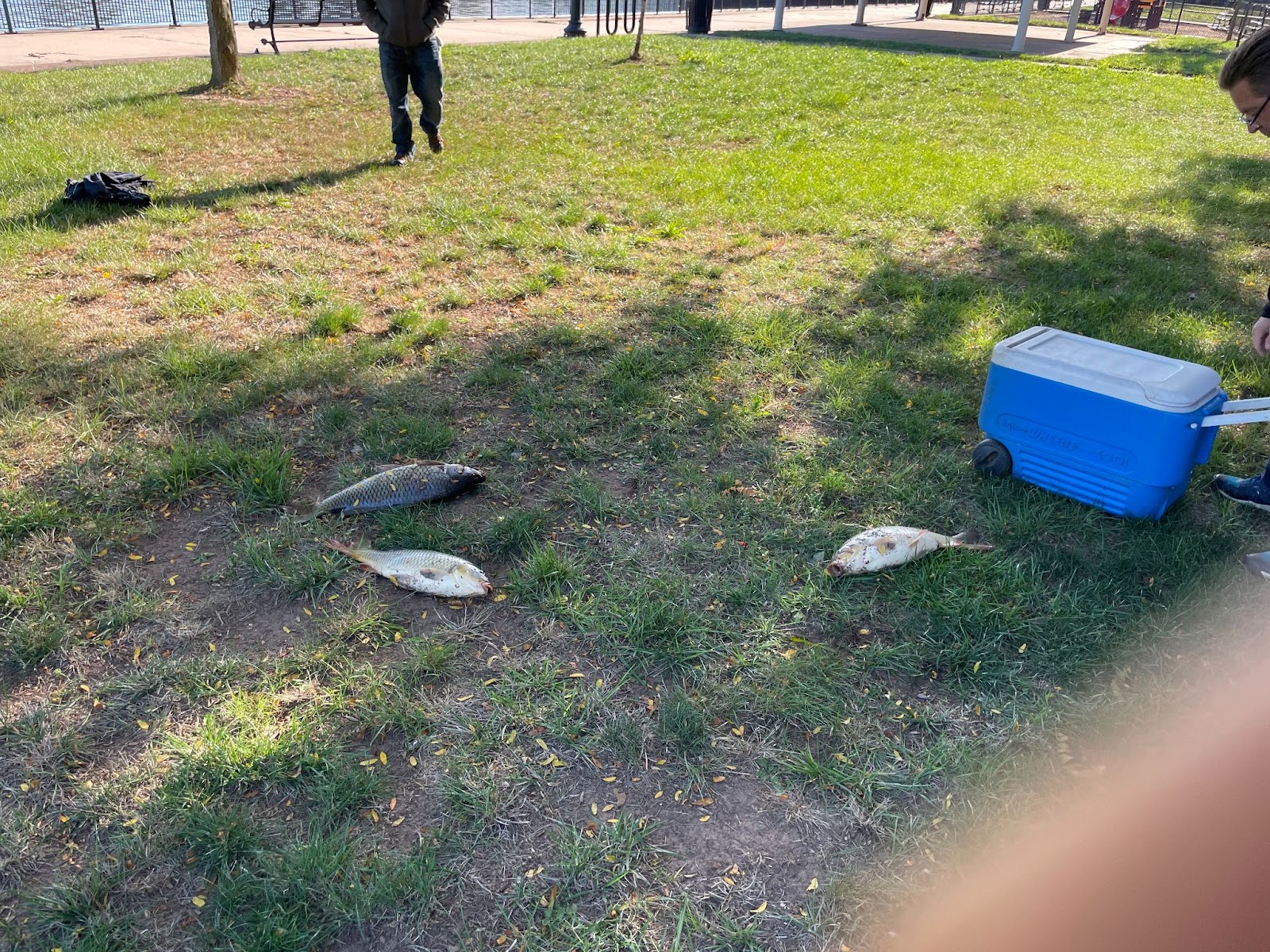
This week, we observed dozens of fish kill at our Edison and Sayreville sites likely from the low levels of dissolved oxygen we recorded, Photo Credits: Andrew Gehman
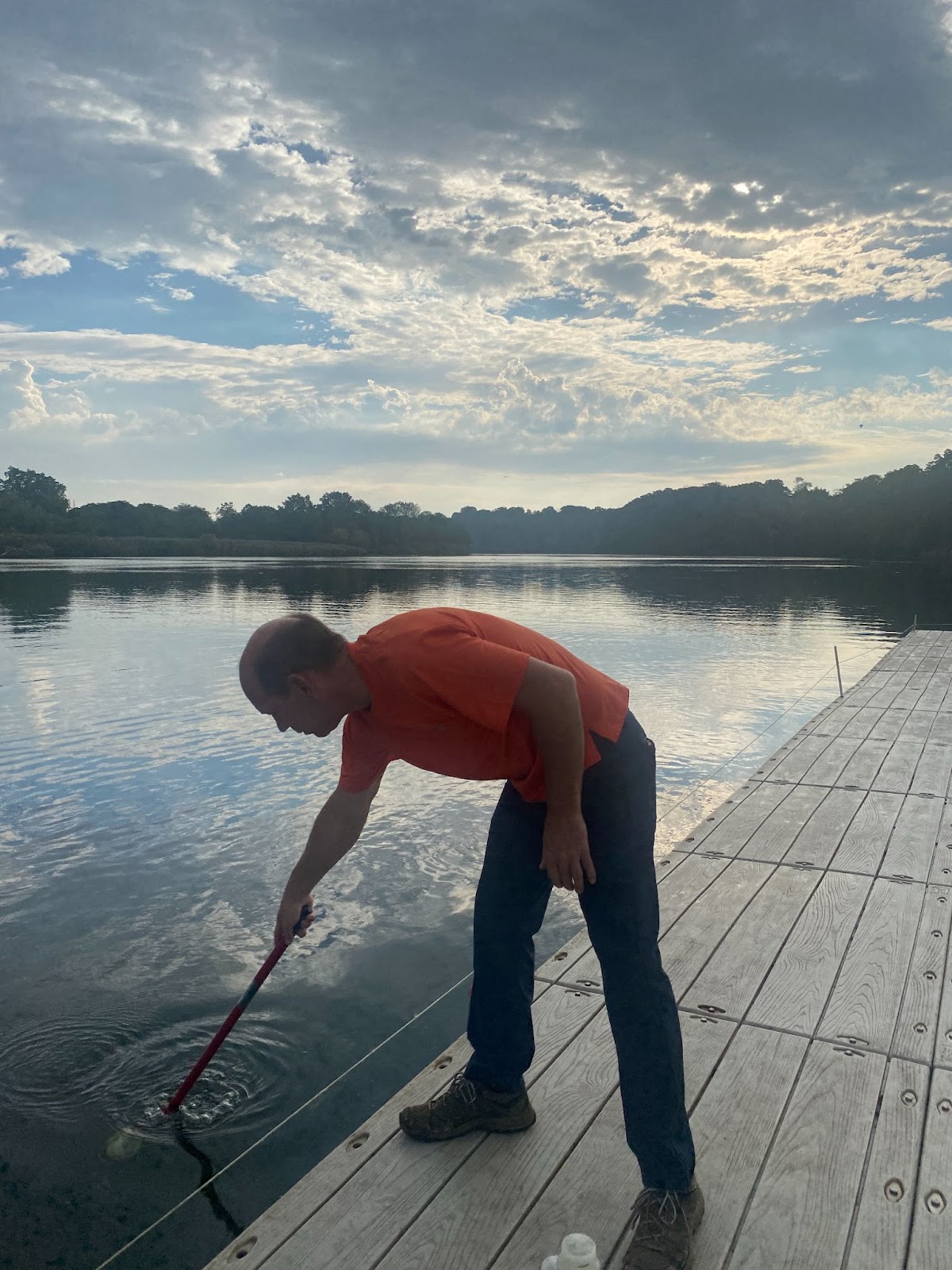
Frank was eager to wade into the water at our South Amboy site this week, he wanted to take samples from the River before the end of the season, Photo Credits: Jocelyn Palomino
The Lower Raritan Watershed Partnership lost a dear friend, Scott G. Yaede, who passed away on Friday September 16, 2022 at home in New Brunswick, NJ.
The environment was Scott’s passion, and he was a member of the New Brunswick Environmental Commission for decades, serving as chairman for many of those years. He conducted yearly environmental clean ups with the City of New Brunswick and was a steadfast volunteer at the annual Raritan River Environmental Festival. Scott was a member of the American Littoral Society and served as one of the first water quality monitors on the Raritan River for the New Jersey Baykeeper in the 1970s.
Scott was involved in early conversations to start up the Lower Raritan Watershed Partnership and was a cheerleader as the organization grew and developed. He was especially supportive of, and involved with, the community boat build program. Until last year he joined most of the LRWP boat build sessions and stream clean ups. Scott was an avid kayaker and could often be seen cleaning up trash as he kayaked along the Raritan River.
With gratitude for your friendship and stewardship, Scott. You are missed!
Scott Yaede shows off the smallest tire found during a clean-up of the Raritan River floodplain in Donaldson Park, October 26, 2019.
Blaze orange leaves adorn this local black oak. Nature’s seasonal clock has struck 10, autumn has arrived as October takes out a full page ad to showcase its array of brilliant color.
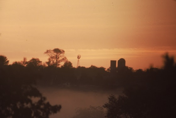
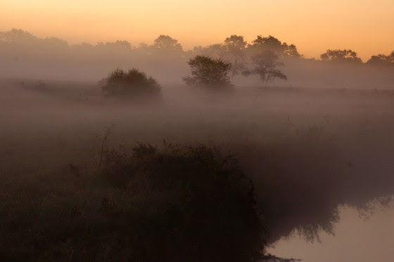
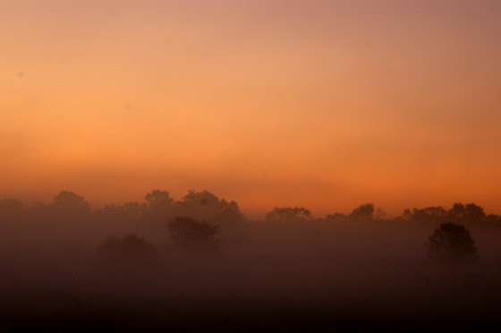
The hot breath of August turns September mornings into a smoldering mist as embers of summer’s end burst into an explosion of October color.
The early morning autumn mists, so prominent along the rivers and brooks that flow gently across the landscape, stir the imagination to reach back in time to a place where magic was the accepted answer to the wonders of nature.
Dark green leaves turning to fluorescent orange is the stuff of wonderment. The purpose of which is to generate thought and build creative answers to perplexing questions. It is as if nature is guiding human evolution to higher intelligence by flashing colorful prompts to articulate a creative response. Creativity is the foundation of knowledge and its application. A warm up exercise for the immersion into disciplined technology, ruled by logic and reason.
The heavy white mist, rising from the river, overflows the pastures, providing a blank slate, into which the light of dawn infuses clouds of ever-changing color. A band of intense pastels emerge from the night and rest upon the horizon to await the sun’s arrival. The first color to appear is a layer of fireball red which cools to an orange glaze, so intense, it appears the world is on fire. Purple streaks fading to rose, pink and salmon support layers of golden yellow, chartreuse and sulfur. This celestial palette, stirred by the rushing wind, spurred on by the sun’s heat clashing with the night’s cool air, disperses the colors to tint the rising river mist.
The predawn light begins to color the rising mist along the South Branch
The early morning light show vanishes into thin air as the sun rises to its zenith above earth. Brilliant blue sky, unmarked by clouds, stand in contrast to the colorful October foliage. Late afternoon herds of fluffy white clouds appear animated as their structures are constantly reshaped by the whim of the wind. Each bold cloud, composed of delineated puffs of white, bordered by shades of gray, compel interpretation as they resemble earthbound faces, animals and objects. Again, a playground for the imagination to run wild, compliment of autumn weather. It is easy to understand how humans used the sky to interpret messages from the beyond, as true in paleolithic times as it is today. Playing with clouds is to share the exact same emotion and interpretive conclusions as long-gone ancestors. The clouds become a portal in that way, piercing the impenetrable wall of time to prompt creative interpretation, likely more aligned than different.
Fluffy white clouds invite the viewer to ride the sea of imagination.
It is the colorful autumn foliage which garnishes the late day clouds and dramatic morning river mists of October. At a distance, woodlands appear as a single undulating blanket, woven with colorful threads, showing irregular swatches of yellow, green and scarlet. Viewed as a time lapse, the colors expand southward, while the northern edge reverts to earth tones of grayish brown as if consumed while on the run, from the hungry wolves of winter.
Brilliant, blaze orange oak leaves defy imagination in their intensity, and stand in bold contrast to the conservative green, brown and gray tones that dominate the landscape. Like a flash of fire, its sight demands our absolute attention as sure as the flash of a lightning bolt. In that long moment of awe, imagination, held in abeyance by reality, rushes in to disrupt the continuity of time.
October is totally dedicated to autumn and all its glorious color, a time when golden mists and billowy white clouds mark the transition between summer and winter; a perfect agreement between two polar opposites.
The trail of Octobers past, is a familiar well-worn path through time, lit with the brilliance of golden leaves, beckoning the traveler deeper into a world of timeless beauty.
The trail of Octobers past, is a familiar well worn path through time, lit with the brilliance of golden leaves, beckoning the traveler deeper into a world of timeless beauty.
Author Joe Mish has been running wild in New Jersey since childhood when he found ways to escape his mother’s watchful eyes. He continues to trek the swamps, rivers and thickets seeking to share, with the residents and visitors, all of the state’s natural beauty hidden within full view. To read more of his writing and view more of his gorgeous photographs visit Winter Bear Rising, his wordpress blog. Joe’s series “Nature on the Raritan, Hidden in Plain View” runs monthly as part of the LRWP “Voices of the Watershed” series. Writing and photos used with permission from the author. Contact jjmish57@msn.com.
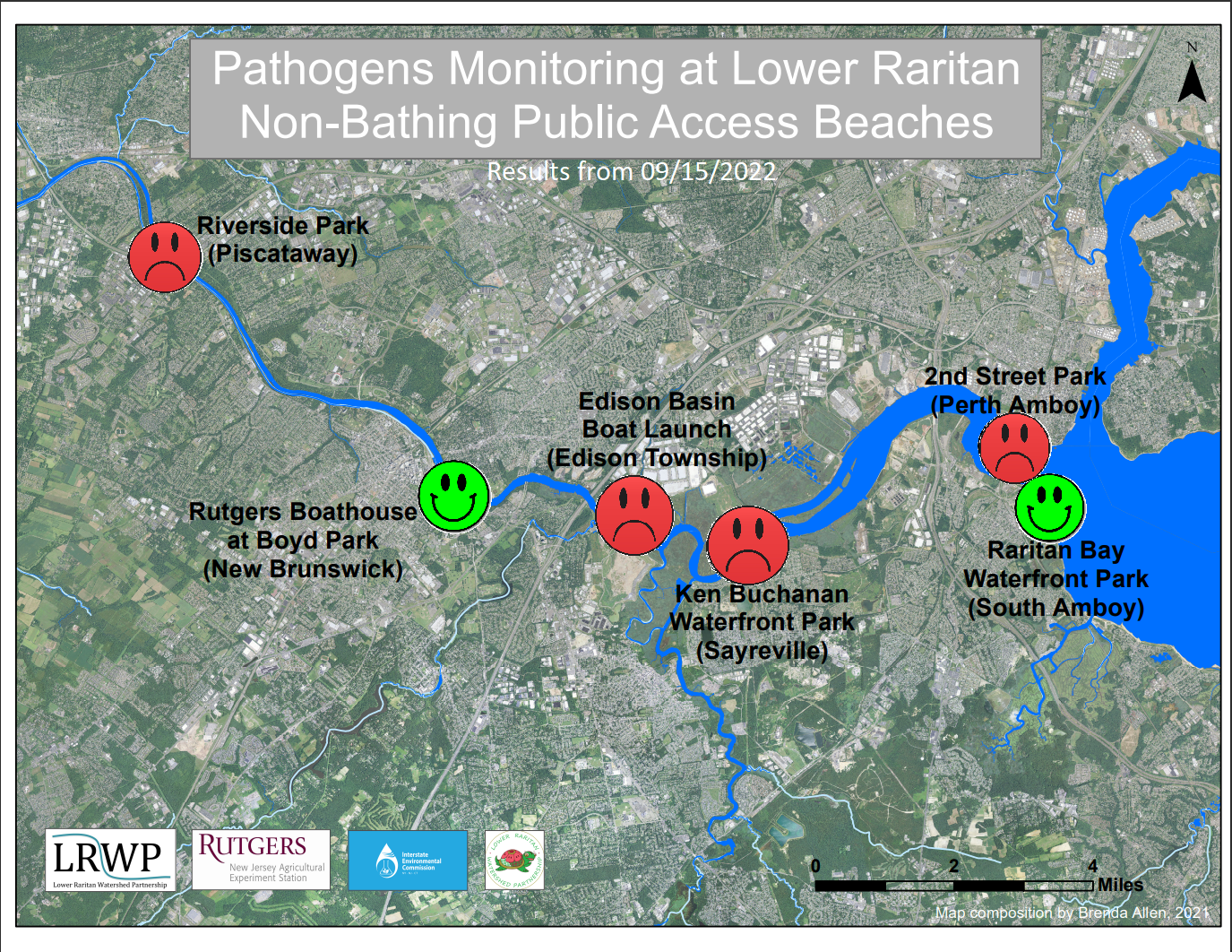
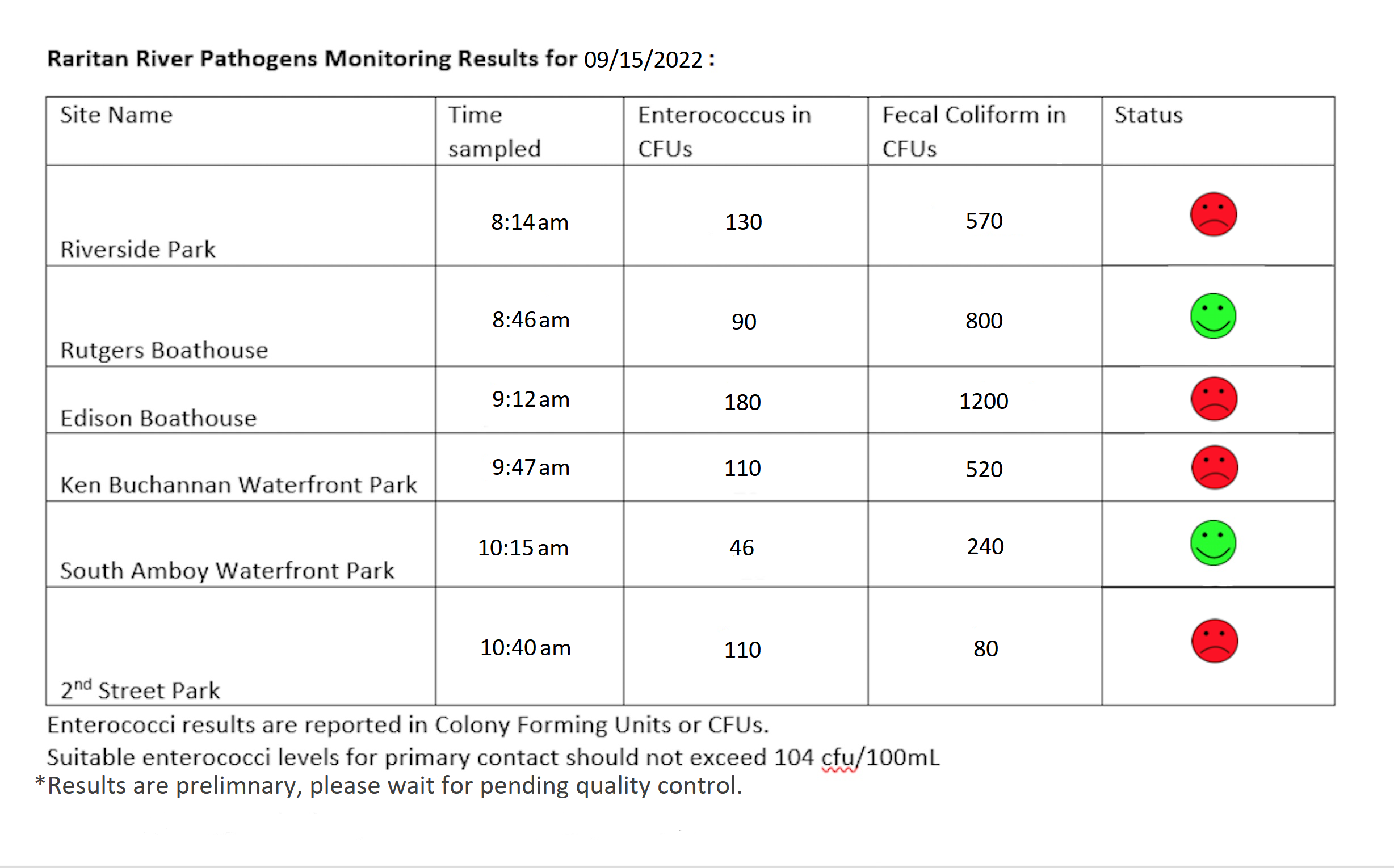
By LRWP Monitoring Outreach Coordinator Jocelyn Palomino
The Lower Raritan Watershed Partnership and Rutgers Cooperative Extension of Middlesex County run a volunteer pathogens monitoring program from May to September every Summer. On Thursdays we collect water quality samples at 6 non-bathing public access beach sites along the Raritan River, provide our samples to the Interstate Environmental Commission for analysis in their laboratory, and report the results to the public on Friday afternoons. Our goal in reporting these results is to give area residents an understanding of potential health risks related to primary contact (touching) the water during water based recreation.
Lab results for water quality samples taken on September 15, 2022 show Enterococcus bacteria levels that exceed the EPA federal water quality standard of 104 cfu/100mL at a majority of our monitoring sites. Problem sites are indicated by red frowns on the map and chart and include Riverside Park (Piscataway), the Edison Boat Ramp (Edison), Ken Buchanan Waterfront Park (Sayreville), and 2nd St. Park (Perth Amboy). The green smiles represent sites with Enterococcus bacteria levels below the federal standard for recreation and include Rutgers Boathouse (New Brunswick) and South Amboy Waterfront Park (South Amboy).
Pathogens/Enterococci levels are used as indicators of the possible presence of disease-causing bacteria in recreational waters. Possible sources of bacteria include Combined Sewer Overflows (CSOs), improperly functioning wastewater treatment plants, stormwater runoff, leaking septic systems, animal carcasses, and runoff from manure storage areas. Such pathogens may pose health risks to people fishing and swimming in a water body. If you choose to recreate on the Raritan, please do so safely and be sure to wash thoroughly after all activities!
Welcome to the LRWP’s new Raritan Scholar intern Jonathan Kim! Volunteer Frank Dahl showed Jonathan how to fill out the data forms. Photo Credit: Andrew Gehman
Andrew Gehman multi-tasked while in the water collecting samples – YSI in one hand, camera in the other taking photos of our beach-based monitoring team! Photo Credits: Andrew Gehman
Frank returned the favor and captured Andrew in action while he held the YSI in place so we could document real-time data of the water , Photo Credits: Frank Dahl