Every Thursday during the summer, from May to October, the Lower Raritan Watershed Partnership and Rutgers Cooperative Extension of Middlesex County run a volunteer-based monitoring program along the Raritan River. We collect water quality samples at SIX non-bathing public access beach sites, provide our samples to the Interstate Environmental Commission for analysis in their laboratory, and report the results to the public on Friday afternoons. Our mission is to share this data with the community and partners to ensure the safe use of the Raritan river for all.
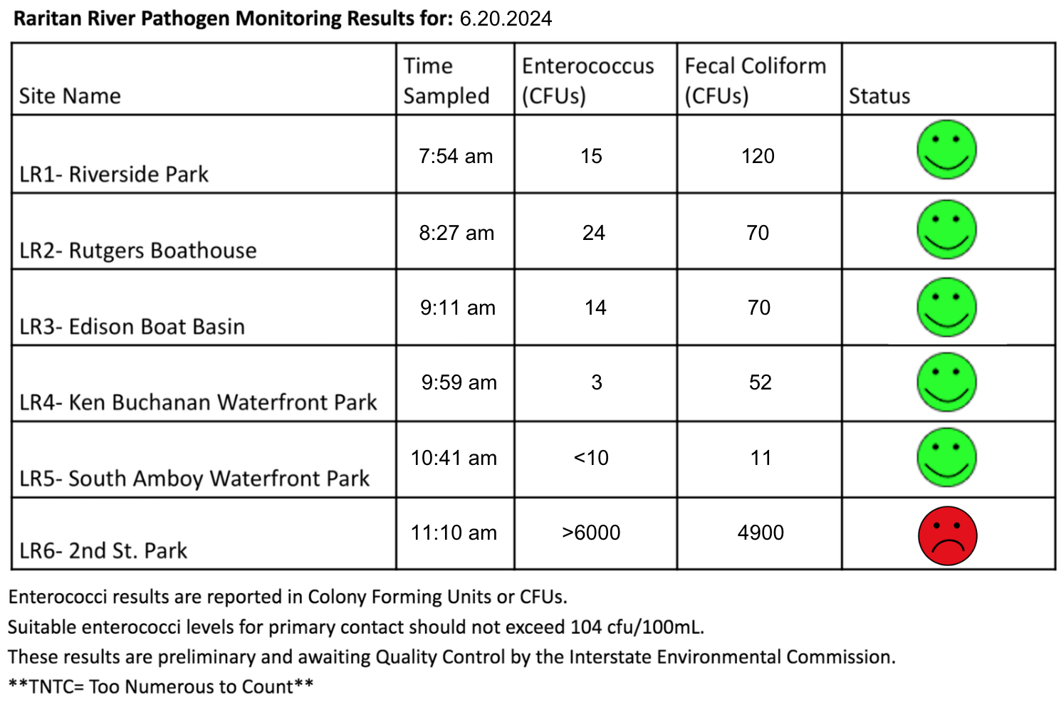
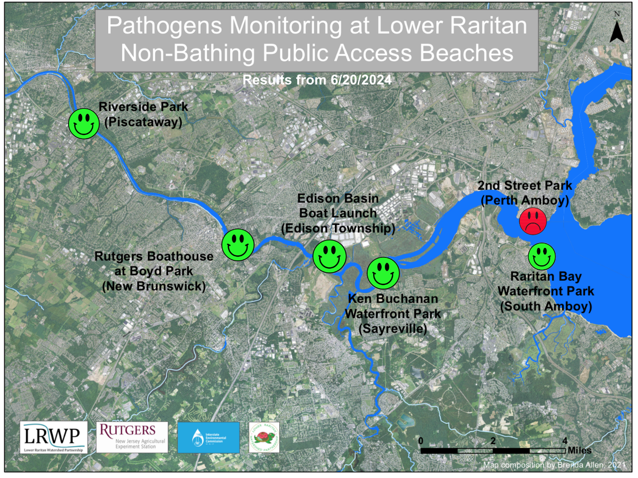
Our lab results for water quality samples taken on Thursday June 20, 2024 show Enterococcus bacteria levels exceeding the EPA federal water quality standard of 104 cfu/100mL at only one of our monitoring sites this week. Problem sites are indicated by red frowns on the map and chart for 2nd Street Park (Perth Amboy) this week. Green smiles on the chart and map indicate the sites with bacteria levels safe for recreation, and include the following: Riverside Park (Piscataway), Rutgers Boathouse (New Brunswick) , Edison Boat Basin and Ken Buchanan Waterfront Park (Sayreville), and South Amboy Waterfront Park (South Amboy).
Pathogens/Enterococci levels are used as indicators of the possible presence of disease-causingbacteriain recreational waters. Such pathogens may pose health risks to people coming in primary contact with the water (touching) through recreational activities like fishing, kayaking or swimming in a water body. Possible sources of bacteria include Combined Sewer Overflows (CSOs), improperly functioning wastewater treatment plants, stormwater runoff, leaking septic systems, animal carcasses, and runoff from manure storage areas.
Our goal in reporting these results is to give residents a better understanding of the potential health risks related to primary contact during water-based recreation. If you are planning on recreating on the Raritan this weekend, make sure to stay safe and wash up after any activities!
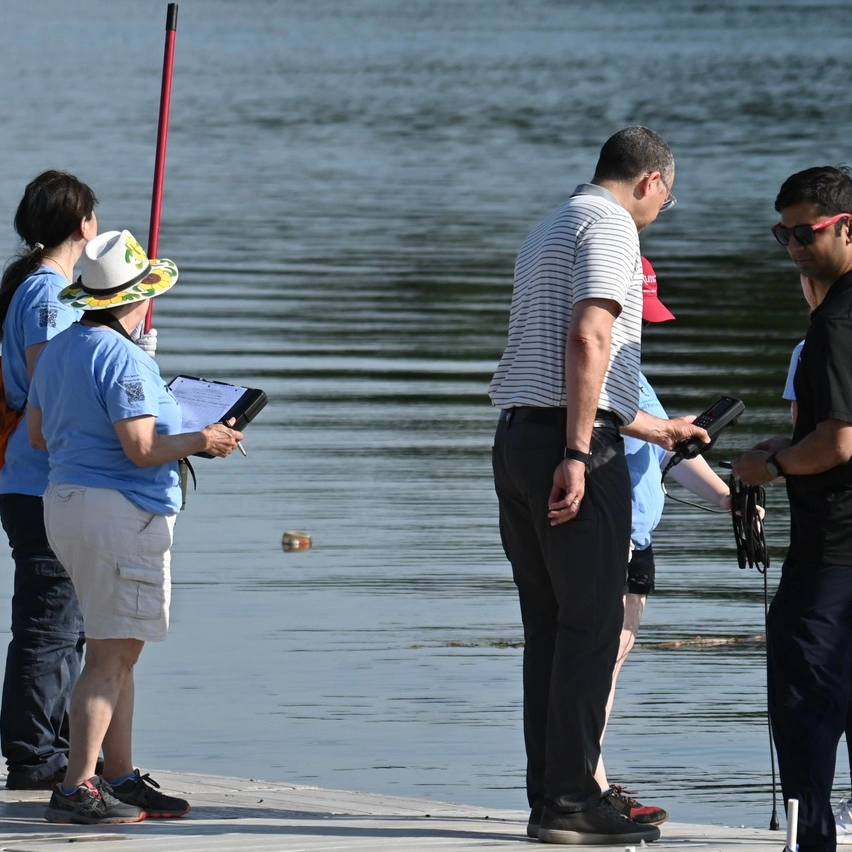
This week, we were fortunate enough to be joined by Rutgers President Holloway at our second monitoring site: The Class of 1914 Rutgers Boathouse! Photo Credit: Trish Maguire
Our volunteers took the reins yesterday and demonstrated how we conduct water quality monitoring as a collective team, check out President Holloway holding our YSI equipment!Photo Credit: Trish Maguire
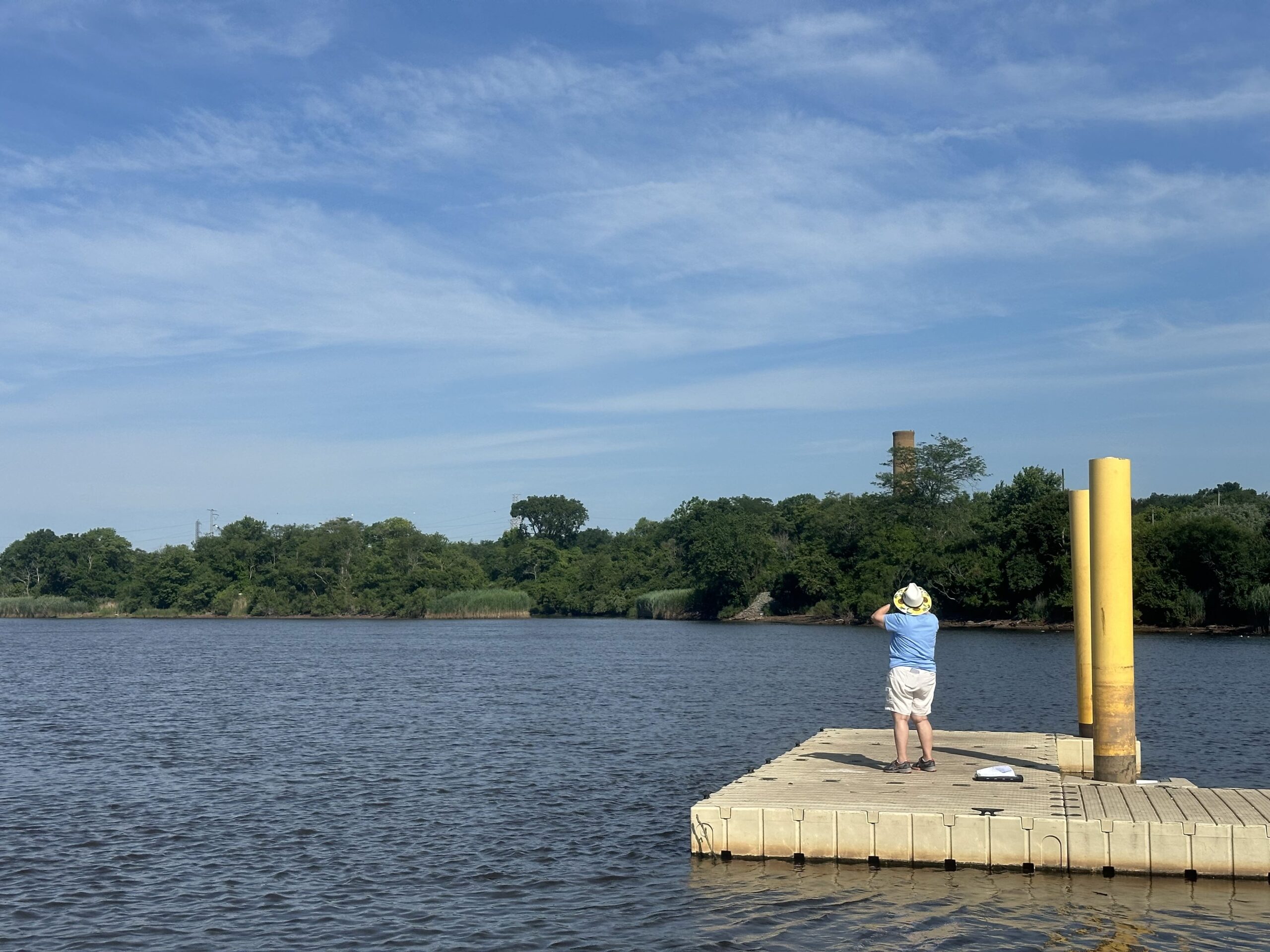
Irene Riegner looking intently through her binoculars to complete our field observation and identify any wildlife present in the area at the time of sampling, Photo Credit: Jocelyn Palomino
Can you spot the osprey nest at our Sayreville site? Photo Credit: Jocelyn Palomino
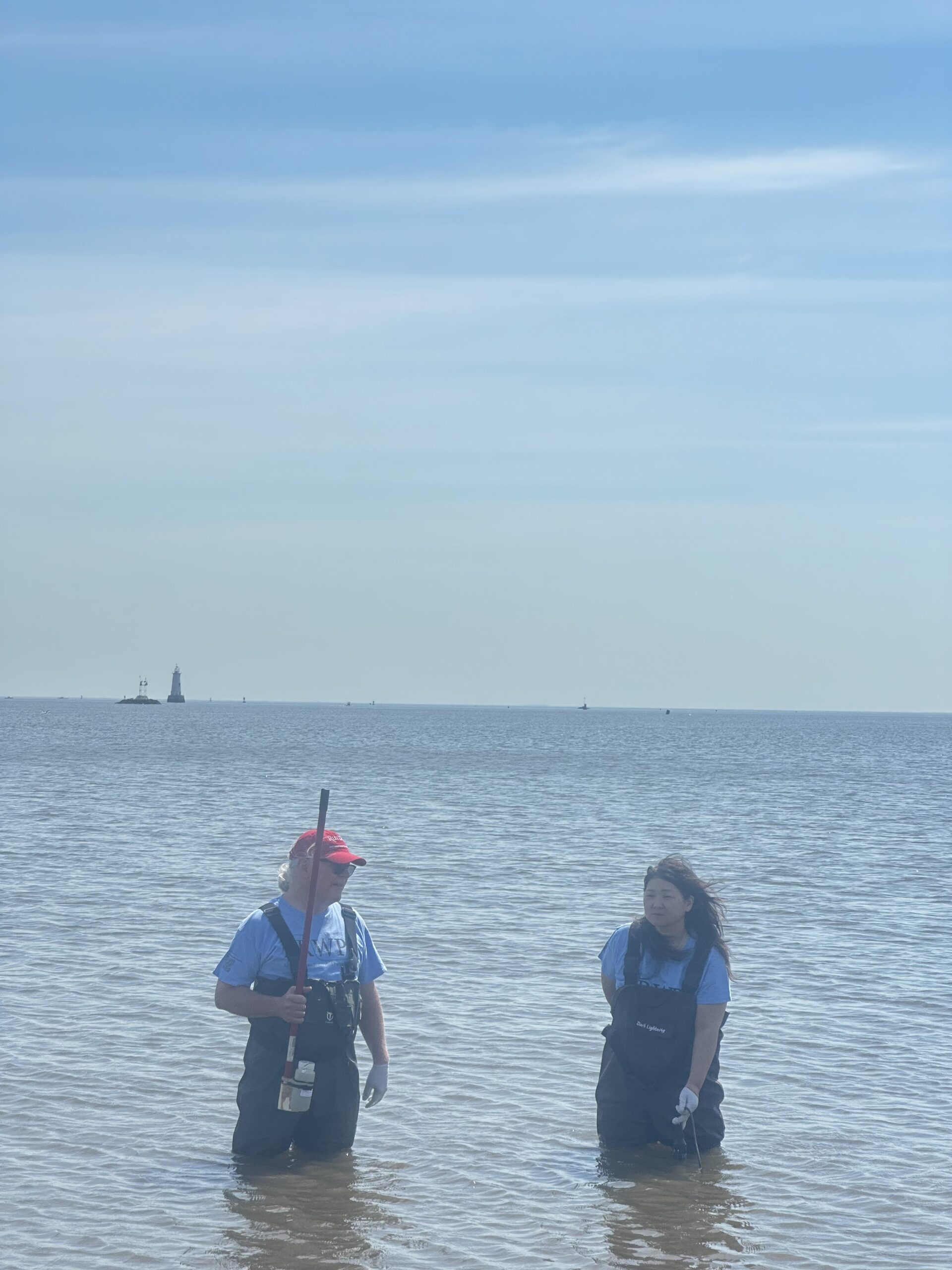
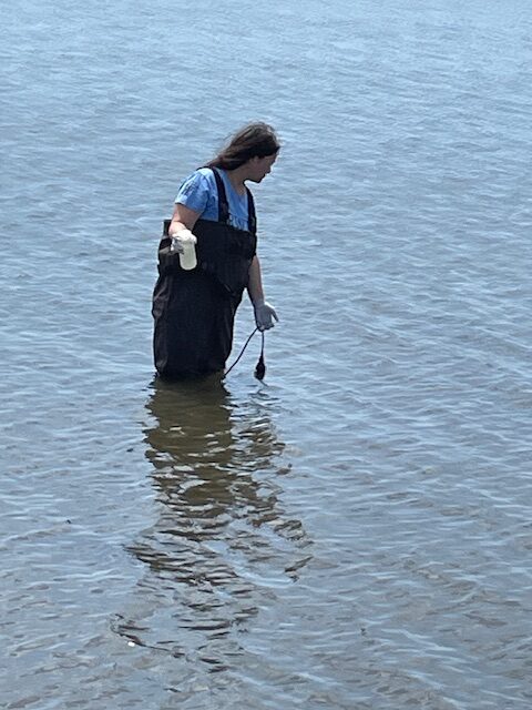
Frank Dahl and Amane Kariya suited up in waders together to collect our sample and data for our South Amboy site, thank you both! Photo Credit: Jocelyn Palomino
The team pictured at our last monitoring location of the day, helping Amane who managed to handle the YSI and sample catching all-in-one go, Photo Credit: Frank Dahl
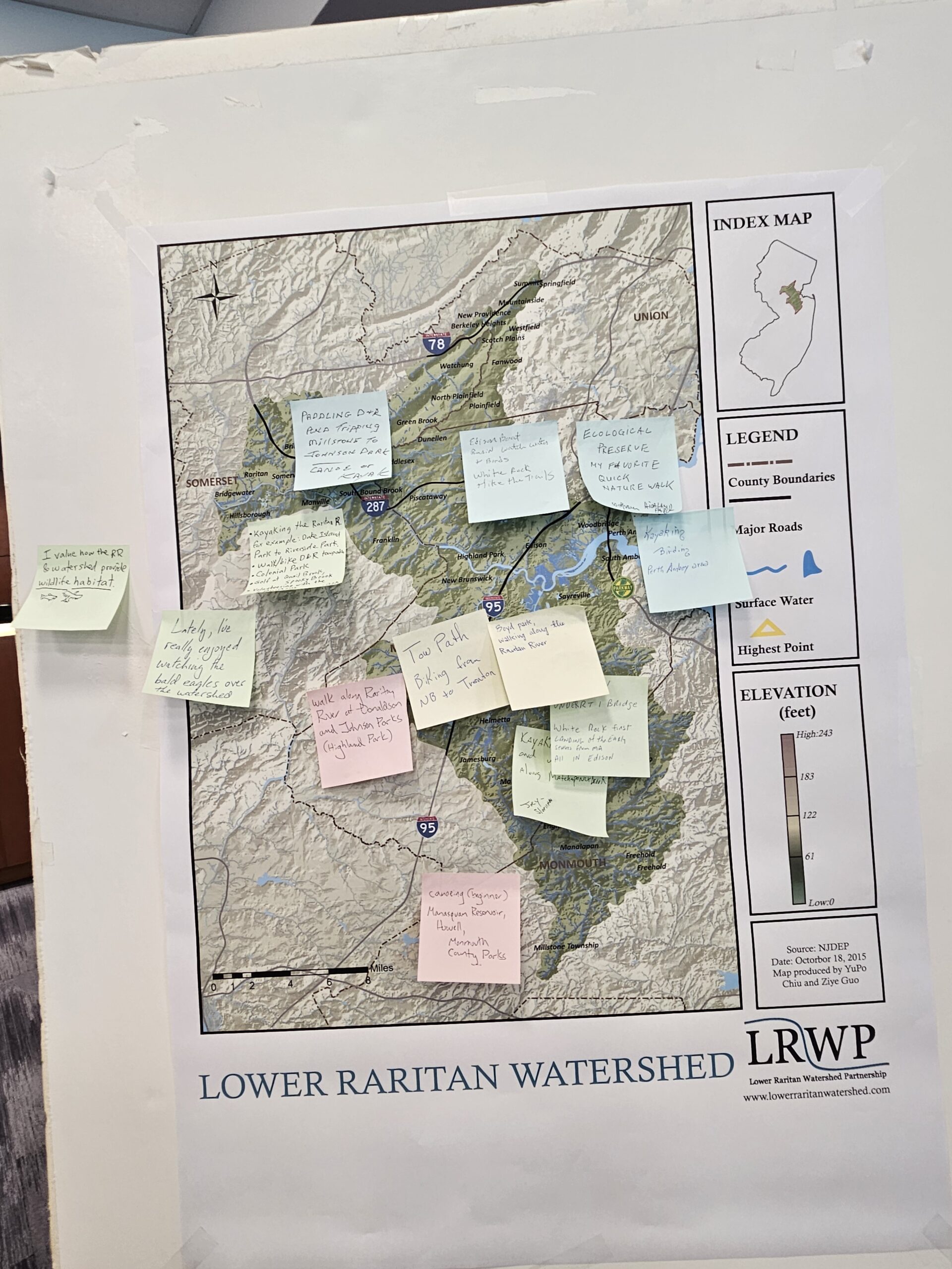
Yesterday, at a special listening session on recreational access to blue and green spaces within the Lower Raritan Watershed, one watershed resident shared their favorite way to access nature: “Lately, I’ve really enjoyed watching the bald eagles over the River.” Even 20 years ago, the idea that bald eagles could be a regular facet of our highly industrialized central New Jersey environment would have sounded like a fever dream, and now it is reality. During the June 11, 2024 listening session, hosted by the Lower Raritan Watershed Partnership (LRWP) and NY/NJ Harbor & Estuary Program (HEP), participants communicated a vision for the next 20 years: a robust network of blueways and greenways connecting local parkland and foot and bike paths within the Lower Raritan Watershed to larger regional and national networks of trails.
The input from this session, summarized below, will not only inform the LRWP’s understanding of recreational priorities but also help shape the HEP Action Agenda for recreation in our region for the next decade and beyond. The session was attended by 31 community members who contributed thoughts on recreational access and the larger state of the watershed. A recording of the session will be available on the LRWP youtube channel, and a bulleted summary of community member responses to a set of questions framed by HEP, is shared here:
Key takeaways can be summarized in response to two questions. The first, “If you could pick one change that’s necessary to have a greener, healthier, and more resilient community — what would that be?” and the second, “What are the challenges and obstacles that face local communities connection and access to nature?”
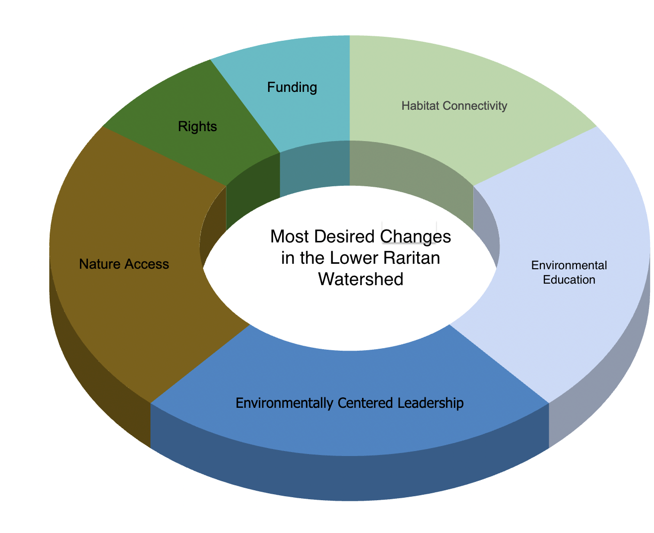
To the first question regarding required changes to realize a greener, healthier, more resilient community, participants communicated six core visions:
23% of respondents advocated for a shift towards environmentally centered leadership, policy, and planning, emphasizing the urgent need for eco-conscious governance.
23% of respondents voiced their desire for increased access to natural features, highlighting the intrinsic connection between human well-being and proximity to nature.
23% of respondents emphasized the critical role of environmental education, advocating for initiatives to raise awareness and empower communities to become stewards of their surroundings.
15% of participants underscored the importance of enhancing habitat connectivity, recognizing the significance of preserving ecological corridors for biodiversity and ecosystem resilience.
8% of respondents pinpointed increased funding as the key catalyst for change in the Lower Raritan Watershed, emphasizing the tangible impact of financial investment in environmental initiatives.
8% advocated for granting rights — akin to human rights — to the Raritan River, signaling a growing movement towards recognizing the intrinsic rights of natural entities.
To the second question regarding challenges and obstacles to realizing this vision, central concerns focused on infrastructure, transportation, and habitat fragmentation.
One participant highlighted how infrastructure like Route 18 acts as a formidable barrier, impeding access to many natural areas. Others pointed to lost opportunities for retrofits that could remedy past disconnections to natural spaces through, e.g. reengineering roadways or repairs of Landing Lane Bridge. As was noted in our session, the construction of Route 18 started as a slum clearing project. This reflects a historical pattern of social injustices where urban planning decisions disregarded not only the environmental impacts but also equity impacts on our communities, and highlights the need for a holistic approach to restoring community health. By acknowledging the historical context of such projects and their environmental implications, we can work towards more equitable and environmentally responsible solutions for our communities.
Limited mass transit connections to green/blue spaces was another concern voiced by participants, with suggestions made to not only prioritize transportation between live-work activities, but also to open and natural spaces. Addressing these challenges requires advocacy for infrastructure improvements, such as championing Boyd Park’s transformation into a state park, as suggested by community members at the session yesterday.
Additional questions included:
Do you wish you had more and/or different opportunities to experience the natural environment?
What kind of opportunities come to mind?
What are other concerns or stressors that your community is currently facing?
How has climate change impacted your community?
Are there places/sites in your community where these concerns are more prevalent?
We invite you to read through the full set of ideas generated during the community engagement session (see above), to watch the video of the session, and welcome your thoughts on how to improve recreational access to blue and green spaces within the Lower Raritan Watershed and beyond.
Although the information in this document has been funded wholly or in part by the United States Environmental Protection Agency under agreement to the Hudson River Foundation for the New York-New Jersey Harbor & Estuary Program, it has not undergone the Agency’s publications review process and therefore, may not necessarily reflect the views of the Agency, and no official endorsement should be inferred. The viewpoints expressed here do not necessarily represent the belief or opinions of the New York-New Jersey Harbor & Estuary Program, Hudson River Foundation, or United States Environmental Protection Agency. They assume no responsibility or liability for the contents or use of the information herein nor does mention of trade names, commercial products, or causes constitute endorsement or recommendation for use.
Article and photos by Theo McDermott-Hughes. The LRWP is grateful to the PSEG Foundation for generous funding support through the PSEG Neighborhood Partners Grant Program for our “Youth Empowerment Through Boat Building”.
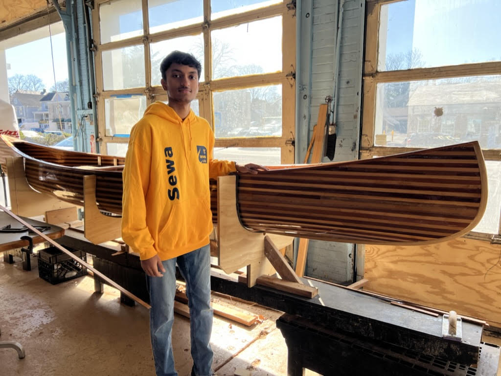
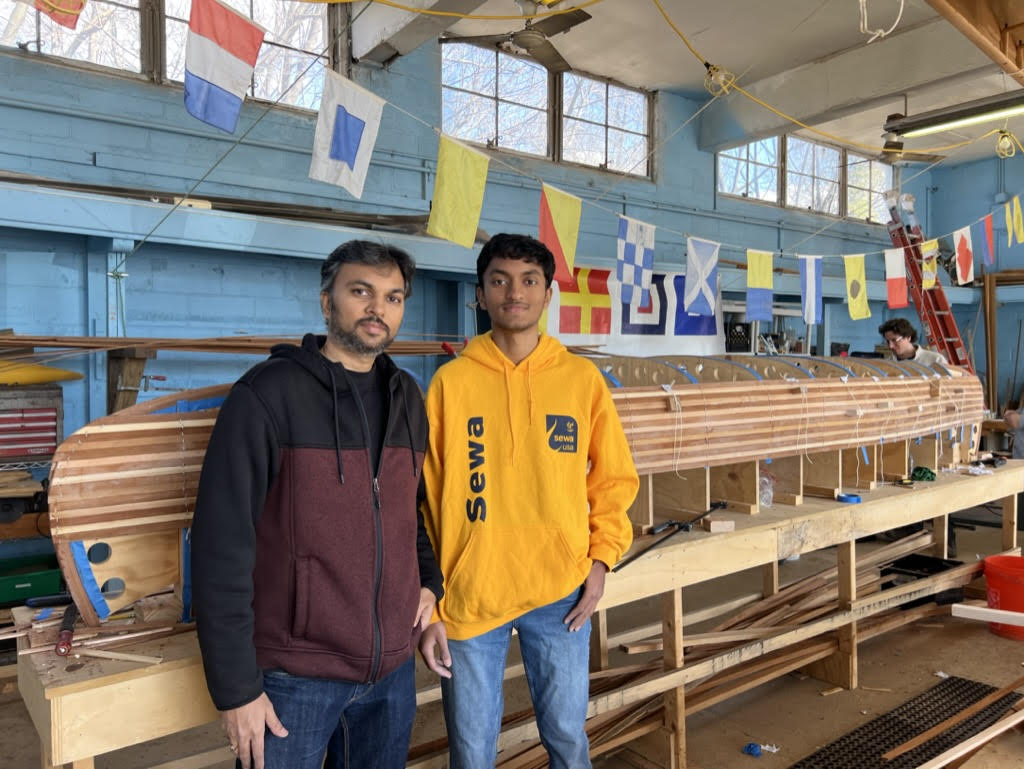
Aadharsh, 16, has always feared the water, making him a perhaps unlikely volunteer for the Lower Raritan Watershed Partnership boat build. This LRWP program aims to increase engagement with and understanding of the Raritan River. Moving water is something Aadharsh had avoided for years, yet this was his second year participating in building a canoe as a member of the Sewa International Central Jersey youth program, which he participates in as a junior at JP Stevens high school.
Aadharsh was drawn to the boat building project and the LRWP because of his love for the environment and dream of being an engineer. After building these boats, starting from the paper designs and research all the way through the construction process of fixing the panels in place and weaving the cane seats, Aadharsh now leads his engineering class at school as they use the same processes and skills he’s already learned in the boat house.
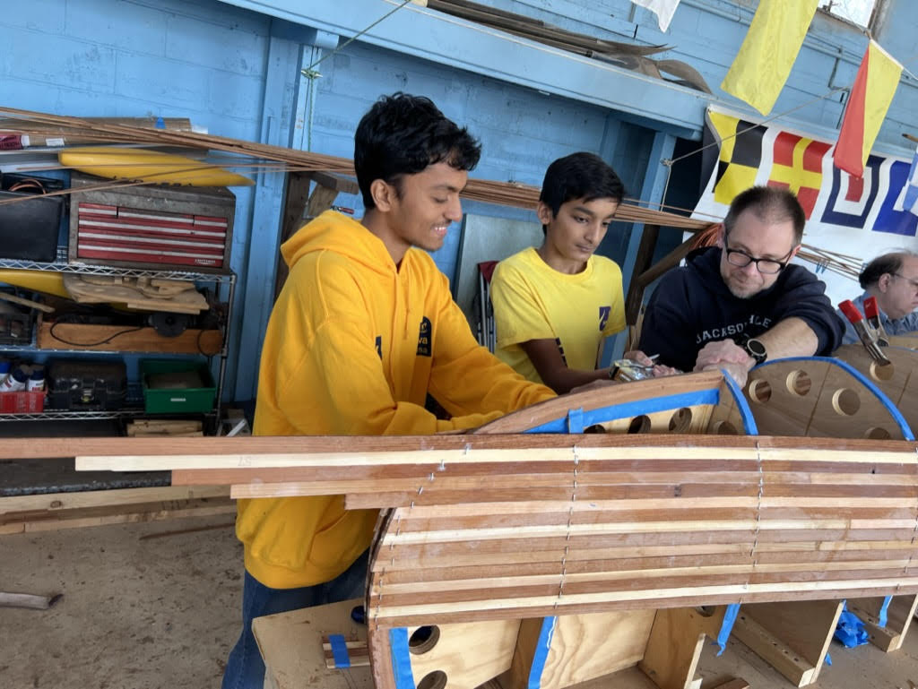
Even more than practical skills and insight into the engineering process, he’s gained deep sense of fulfillment, one he struggled to express as he laid his hands on the lacquered hull of last year’s canoe. “Watching the boat come to life” under his hands gives him the energy to come back each week. He gazed at the panels striping the side of the boat with a sense of awe, bordering on reverence. “You see that?,” he said. “We did that.”
As Aadharsh’s father, Sakkaravarthy, watched his son work with other volunteers to attach the paneling, he expressed his great pride. He always tries to sign up to chaperone the teen volunteers when Aadharsh comes to the build. Not only does he get to watch his son explore his passion, when they return home and Aadharsh inevitably spends dinner enthusiastically talking about what he did at the boat build, Amid can smile along with understanding and pride.
Now, both father and son look forward to the boat launch, when the new canoe will hit the water for the first time this summer along with past years’ boats. Aadharsh can’t wait to paddle down the river that was once such a source of fear.
Join LRWP volunteers like Aadharsh and Sakkaravarthy at our boat-building session on Wednesdays from 6-8 and Saturdays 9-11. Pre-registration required. See you soon!
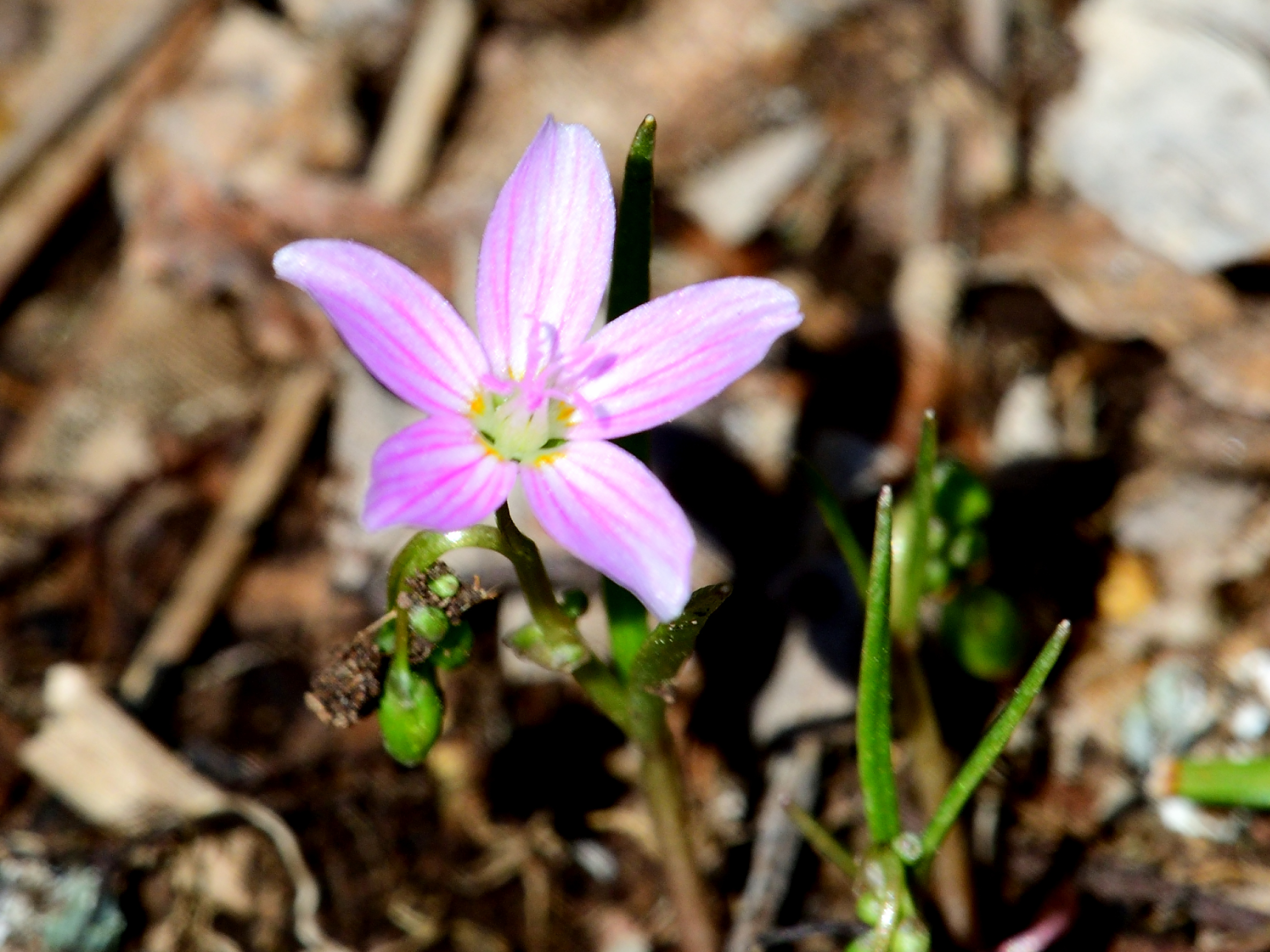
There is magic in the first wildflowers which dare to dance in April’s cool breeze. Look closely at the pinstriped Spring Beauty to see the face of an impish sprite staring back.
March knocks on April’s door, and standing there on the dim lit stoop is a visage surrounded by swirling ice and snow, dripping mud and melting frost. Without hesitation, April invites the disheveled traveler in and notices a small parcel wrapped in green, wet with melted snowflakes. It is the gift of spring, and with it comes the remnants of the wintry month’s mercurial weather. As April encourages the sun to stay a while longer each day, the influence of March’s wintry heritage is diminished. A mere promise of favorable conditions is enough to encourage a veil of green to emerge from the cold ground in a resurrection of dormant life.
Within this transitional framework, the brilliant tints of green enliven the dull gray landscape to rouse curiosity and focus attention toward the earth. Energy is a key element in attraction and April is a time of palpable and boundless energy. The invisible movement of time appears betrayed as plants seem animated and grow before our eyes. Many spring plants have a narrow window of opportunity to emerge and mature, so their growth is accelerated.
Spring beauties are ephemerals which grow in isolated patches in open woods and among short pasture grass, their pink and white stripped flowers linger into May. Each short-stemmed flower is distinctly different in petal stripe and color. Some variants are almost all white with faint pink stripes, while a neighboring patch may be dominated by deeper pink petals and dark pink stripes. Color and pattern variations are the rule, which makes this flower so interesting. The variation in a way, compliments the vagaries of early spring weather and the individual character each April presents.
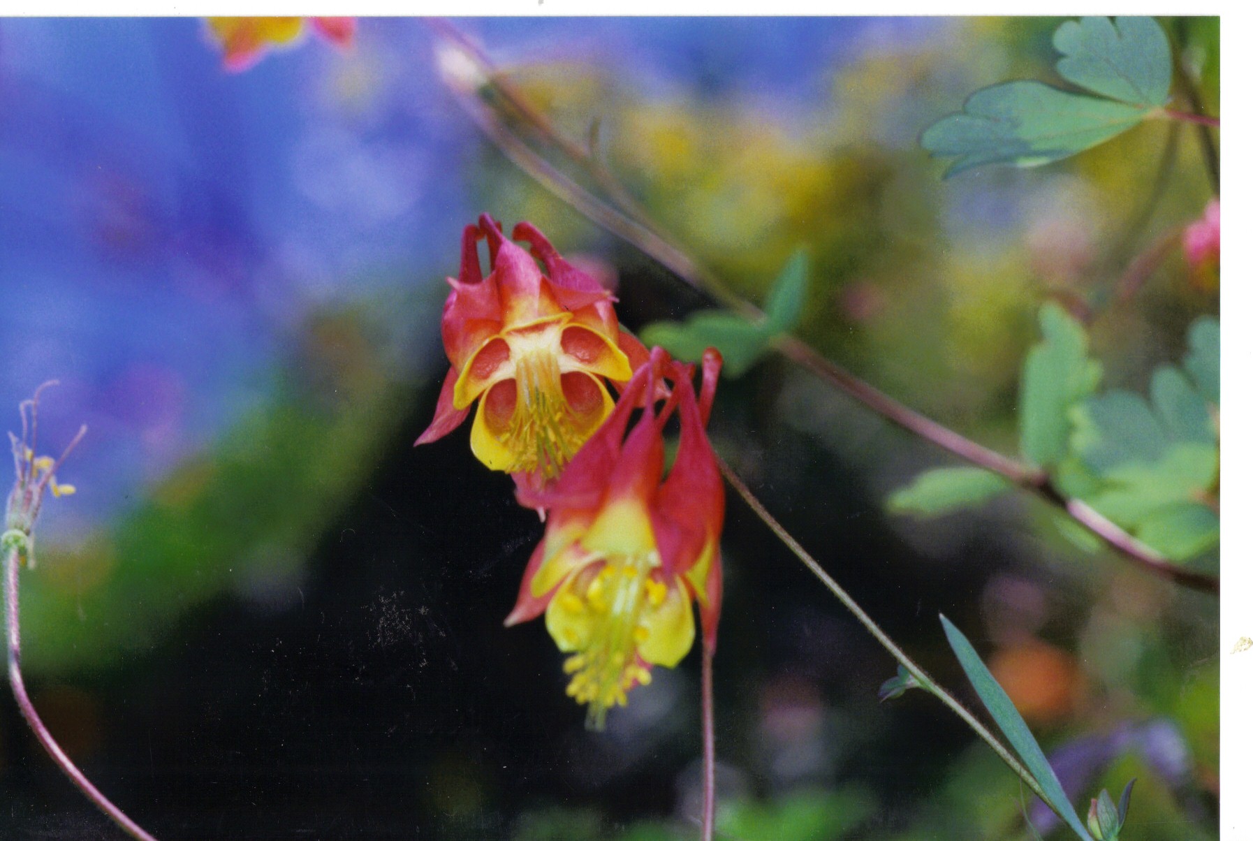
A calendar is not needed to know April has arrived. The appearance of native columbine on the red shale cliffs along the South Branch of the Raritan are as dependable a sign as any numeric score card. There is security in predictability and despite changing weather patterns, columbine remains faithful to April.
Native columbine is a delicate long stem, dark red, inverted, single bloom, composed of four or five individual vase shaped tubes, which collectively terminate in the appearance of a crown where the inverted flower meets the stem. Each tube within the red flower is lined with bright yellow. A distinctive broad, three lobed, pale green leaf adorns each stem and easily catches a breeze to help disperse seeds when the plant matures in early May. Columbine does not grow in profusion and is best described as being found in isolated villages, tucked in among the maroon cliffs. I wonder how many Aprils these cliff dwelling plants have seen, as their existence in such an austere shale environment is not conducive to random dispersal. I think of Brigadoon, a mythical village that appears once every one-hundred years, when native columbine appear during April, on the face of ancient cliffs, otherwise devoid of life.
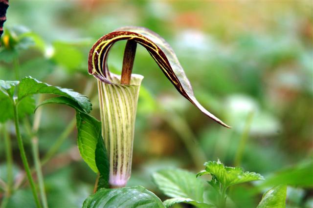
April’s charm and promise find a spokesman in the form of Jack in the pulpit. As the name implies, this early spring plant appears to portray a minister standing in a raised pulpit, leading the congregation in prayer and praise for the gifts of nature. The personification of this unique plant, based on its shape and form, perfectly fit myth, magic, and folk lore promoting a human/ plant interface. The appearance of Jack standing in a pulpit, could be perceived as a reincarnation or memorial to a revered patriarch.
Any natural phenomenon begs for an explanation, and in this way, April delivers a lesson in the most critical of survival tools, creativity, and imagination. The earliest flowers to appear under April’s umbrella are a sign of hope as they stand in sharp contrast to the stark landscape about to awaken. Consider that flowers are living things that in some magical way, recruited man to further their propagation in exchange for a glimpse of eternal beauty, dreams and imagination. All combined to expand the universe of human potential with unbounded creativity and expression.
April has opened the gift of spring March delivered, and has swept its fresh green carpet clean of any wintry remnants tracked in when the gift was delivered. Conscious of its fleeting time allotted, April honors the delivery of the next month’s explosion of blooms by taming the weather and warming the soil. When may flowers arrive, April deserves a special thanks.
Author Joe Mish has been running wild in New Jersey since childhood when he found ways to escape his mother’s watchful eyes. He continues to trek the swamps, rivers and thickets seeking to share, with the residents and visitors, all of the state’s natural beauty hidden within full view. To read more of his writing and view more of his gorgeous photographs visit Winter Bear Rising, his wordpress blog. Joe’s series “Nature on the Raritan, Hidden in Plain View” runs monthly as part of the LRWP “Voices of the Watershed” series. Writing and photos used with permission from the author.
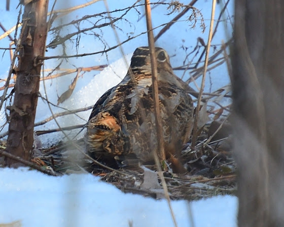
A fox sparrow takes refuge from a late March snowstorm as it migrates north to its breeding grounds
The fluffy white blanket of an early March snowstorm, preserved by the cold days that followed, began to shrink as the sun fought the darkness for dominance. The snow cover was still unbroken as it grudgingly settled lower each passing day. Eventually the white blanket would lose its loft and become threadbare, unveiling the gravid brown earth.
The days following the storm dawned clear and cloudless. The night sky was a showcase of brilliant white diamonds, alive with energy as they sparkled in the infinite celestial darkness.
An hour before sunrise the west facing snow covered hillside reflected enough light to reveal the fine detail of the skeletal silhouettes of every tree and bush that stood above the white ground cover. Even as the sky began to brighten, the entire hillside remained in shade, preserving the dramatic pre-dawn contrast. For a few slow minutes, the sky above the hill was bathed in a diffuse aura of gold, fading into white, which blended into the palest blue, growing more intense as the brightest stars lingered and were lost among the deepening blue background. For a long moment, night and day, past and present coexisted at one glance. The dynamic scene, frozen on an imaginary vertical tapestry, the black and white hillside held in sharp contrast to the gold and sunlit blue sky above.
In a way, that dawn was symbolic of the dichotomy of March, as the month ushers in the last cold breath of winter and departs amid life emerging from dormancy under the influence of increasing daylength.
Maroon, orange, green, and red buds decorate the bare tree branches to rival fall color, as early spring flowers tolerate the mercurial weather and defiantly poke through any errant late Match snowfall.
Bird migration is now in full swing as flycatchers, osprey, and colorful warblers make their appearance.
Great horned owls, hatched a month earlier, are flightless and near adult size.
March is the best time to find migrating woodcock and observe the unique mating flights performed by the males at dusk, choreographed to impress a potential mate. Woodcock were common locally in open woods and damp fields. As habitat dwindles, any sighting becomes a rare treat. When March rolls around I head for a likely spot where a swale is formed by the earlier mentioned hillside. The hillside is drained by a seasonal stream which remains wet where the gradient levels. The saturated soil creates a perfect environment for earthworms, the main food source for migrating woodcock. Woodcock, also known as Timberdoodles, will often sit tight and allow a close approach.
All migrating birds must deal with unpredictable weather anywhere along their migration path. So, arrival at any one location will vary from year to year. It is somehow comforting when birds that migrate through, show up on schedule. All is right with the world. When snow buntings, headed to points north, stop over at a specific location year after year, a dependence of sort can develop on behalf of the observer. The snowbirds become a reference point, much as a birthday or anniversary.
March provides the ‘wind beneath the wings’ of migrating birds as well as sweeps the land and grooms the trees, wind and March are inseparable.
March has earned the reputation as the month of relentless wind as it rushes mercurial weather on and off the stage to stir the breeze. Think about the wind and the scale of expression from hurricanes and tornadoes to a gentle whisper, where the wind uses a dried stem of grass or tree branch to etch its thoughts in the snow or on the side of an old wooden barn.
The first day of spring will happen on the nineteenth day of March, 2024, at 11: 06 pm. Day and night reach perfect equilibrium for a split second as winter surrenders to spring.
Author Joe Mish has been running wild in New Jersey since childhood when he found ways to escape his mother’s watchful eyes. He continues to trek the swamps, rivers and thickets seeking to share, with the residents and visitors, all of the state’s natural beauty hidden within full view. To read more of his writing and view more of his gorgeous photographs visit Winter Bear Rising, his wordpress blog. Joe’s series “Nature on the Raritan, Hidden in Plain View” runs monthly as part of the LRWP “Voices of the Watershed” series. Writing and photos used with permission from the author.
By LRWP Monitoring Outreach Coordinator Jocelyn Palomino
The Lower Raritan Watershed Partnership and Rutgers Cooperative Extension of Middlesex County run a volunteer pathogens monitoring program from May to September every summer along the Raritan River. We collect water quality samples at non-bathing public access beach sites, provide our samples to the Interstate Environmental Commission for analysis in their laboratory, and report the results to the public on Friday afternoons.
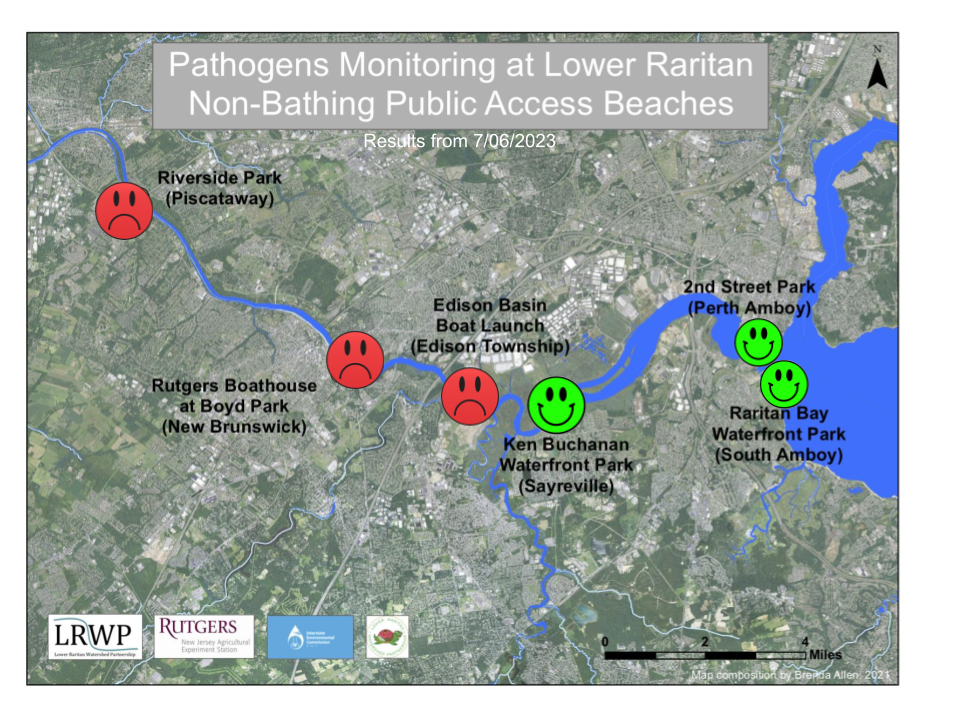
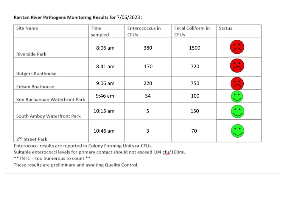
Our lab results for water quality samples taken on July 06, 2023 show Enterococcus bacteria levels exceed the EPA federal water quality standard of 104 cfu/100mL at three of our monitoring sites this week. Problem sites are indicated by red frowns on the map and chart which includes: Riverside Park (Piscataway), Rutgers Boathouse (New Brunswick), and Edison Boat Basin (Edison). Green smiles on the chart and map indicate sites with bacteria levels safe for recreation and includes: Ken Buchanan Waterfront Park (Sayreville), South Amboy Waterfront Park (South Amboy), and 2nd Street Park (Perth Amboy).
Pathogens/Enterococci levels are used as indicators of the possible presence of disease-causing bacteria in recreational waters. Such pathogens may pose health risks to people fishing and swimming in a water body. Possible sources of bacteria include Combined Sewer Overflows (CSOs), improperly functioning wastewater treatment plants, stormwater runoff, leaking septic systems, animal carcasses, and runoff from manure storage areas.
Our goal in reporting these results is to give area residents an understanding of potential health risks related to primary contact (touching) the water during water based recreation. Please remember to always wash thoroughly after all activities if you choose to recreate on the Raritan!
A few cormorants joined us on the water at Riverside Park, Photo Credit: Rose Lawless
The beautiful weather this Thursday allowed us to get some nice shots while we were sampling, Photo Credit: Rose Lawless
Our volunteers enjoy coming together every week to collect the necessary data the community needs for their weekend plans, Photo Credit: Jocelyn Palomino
Piash Ahamed and Rose Lawless helping out Genevieve Ehasz who’s geared up to collect our samples at the South Amboy Waterfront, Photo Credit: Jocelyn Palomino
Can you spot our team of volunteers next to this enormous crane at Perth Amboy’s 2nd St. Park? Photo Credit: Rose Lawless
By LRWP Monitoring Outreach Coordinator Jocelyn Palomino
The Lower Raritan Watershed Partnership and Rutgers Cooperative Extension of Middlesex County run a volunteer pathogens monitoring program from May to September every summer along the Raritan River. We collect water quality samples at non-bathing public access beach sites, provide our samples to the Interstate Environmental Commission for analysis in their laboratory, and report the results to the public on Friday afternoons.
Our lab results for water quality samples taken on June 15, 2023 show that Enterococcus bacteria levels DO NOT exceed the EPA federal water quality standard at any of our sites this week. Green smiles on the chart and map indicate sites with bacteria levels safe for recreation which includes all of our sites this week: Riverside Park (Piscataway), Rutgers Boathouse (New Brunswick), Edison Boat Ramp and Ken Buchanan Waterfront Park (Edison), South Amboy Waterfront Park (South Amboy), and 2nd Street Park (Perth Amboy).
Pathogens/Enterococci levels are used as indicators of the possible presence of disease-causing bacteria in recreational waters. Such pathogens may pose health risks to people fishing and swimming in a water body. Possible sources of bacteria include Combined Sewer Overflows (CSOs), improperly functioning wastewater treatment plants, stormwater runoff, leaking septic systems, animal carcasses, and runoff from manure storage areas.
Our goal in reporting these results is to give area residents an understanding of potential health risks related to primary contact (touching) the water during water based recreation. Even though our results show water quality levels are safe for recreation this week, please wash thoroughly after all activities if you choose to recreate on the Raritan!
Views as we collect our samples from the Rutgers Boat Dock, Photo Credit: Rose Lawless
We had a large group on the docks this week with a few visitors from Rutgers who joined the team to observe, Photo Credit: Jocelyn Palomino
Rose Lawless carefully logging the data onto the YSI, Colleen Georges collecting samples in the back, and Frank Dahl observing the area with his binoculars behind her, Photo Credit: Jocelyn Palomino
Colleen is always happy to jump into the waders and collect some samples, Photo Credit: Genevieve Ehasz
At our last stop in Perth Amboy, we were joined by the 4th Grade class of Mrs. Laura Toto who came out to observe our work, Photo Credit: Rose Lawless
Special thanks to Mrs. Toto and the 4th Grade students at RN Wilentz Elementary School in Perth Amboy for joining us at our last site to learn all about water quality! Photo Credit: Rose Lawless
By LRWP Monitoring Outreach Coordinator Jocelyn Palomino
The Lower Raritan Watershed Partnership and Rutgers Cooperative Extension of Middlesex County run a volunteer pathogens monitoring program from May to September every summer along the Raritan River. We collect water quality samples at non-bathing public access beach sites, provide our samples to the Interstate Environmental Commission for analysis in their laboratory, and report the results to the public on Friday afternoons.
This week we experienced severely heavy air pollution in the Northeast due to the wildfires happening in Canada. The Air Quality Index (AQI) almost reached 400 in several areas of New Jersey, becoming one of the worst smoke outbreaks the Northeast has seen in the last two decades.
Our lab results for water quality samples taken on June 8, 2023 show that Enterococcus bacteria levels DO NOT exceed the EPA federal water quality standard at any of our sites this week. Green smiles on the chart and map indicate sites with bacteria levels safe for recreation which includes all of our sites this week: Riverside Park (Piscataway), Rutgers Boathouse (New Brunswick), Edison Boat Ramp and Ken Buchanan Waterfront Park (Edison), South Amboy Waterfront Park (South Amboy), and 2nd Street Park (Perth Amboy).
Pathogens/Enterococci levels are used as indicators of the possible presence of disease-causing bacteria in recreational waters. Such pathogens may pose health risks to people fishing and swimming in a water body. Possible sources of bacteria include Combined Sewer Overflows (CSOs), improperly functioning wastewater treatment plants, stormwater runoff, leaking septic systems, animal carcasses, and runoff from manure storage areas.
Our goal in reporting these results is to give area residents an understanding of potential health risks related to primary contact (touching) the water during water based recreation. Even though our results show water quality levels are safe for recreation this week, please wash thoroughly after all activities if you choose to recreate on the Raritan!
Special thanks to our monitoring team this week for enduring the weather conditions to provide the community with the water quality results to make the appropriate decisions regarding their recreational plans for the weekend: Colleen Georges, Rose Lawless, Sheyla Casco, and Genevieve Ehasz with the Fahrenfeld Lab.
While exploring at our Piscataway site, Rose Lawless spotted Garlic Mustard, a non-native plant. Photo Credit: Rose Lawless
From the Rutgers boat dock, we could see the trees along the Raritan surrounded by smoke from the Canadian wildfires, Photo Credit: Rose Lawless
A great blue heron surfing on the debris while we collected samples at the Edison Boat Launch, Photo Credit: Rose Lawless
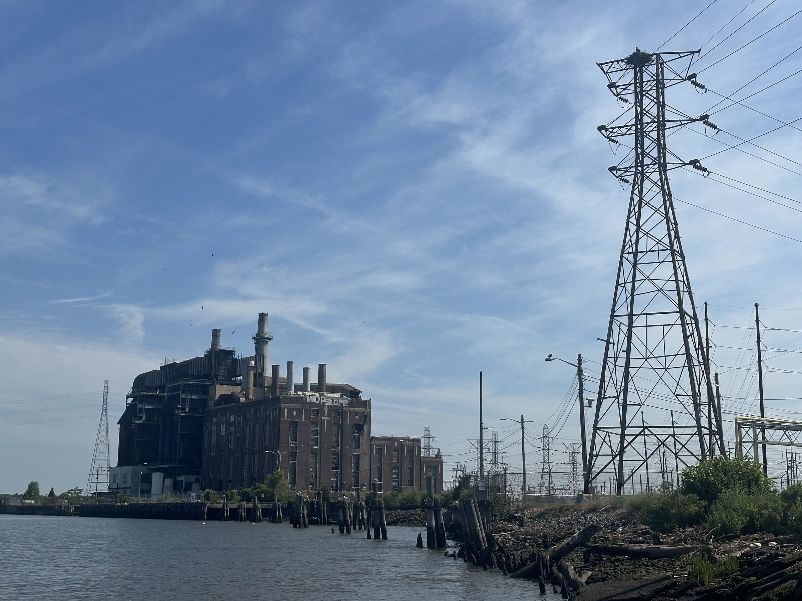
A great image of the team at our Sayreville site with what used to be a coal power plant pictured behind us, Photo Credit: Rose Lawless
Genevieve decided to wade in as we finished up the day in Perth Amboy by 2nd. Street Park, Photo Credit: Rose Lawless
By LRWP Monitoring Outreach Coordinator Jocelyn Palomino
The Lower Raritan Watershed Partnership and Rutgers Cooperative Extension of Middlesex County run a volunteer pathogens monitoring program from May to September every summer along the Raritan River. We collect water quality samples at non-bathing public access beach sites, provide our samples to the Interstate Environmental Commission for analysis in their laboratory, and report the results to the public on Friday afternoons.
Our lab results for water quality samples taken on June 1, 2023 show that Enterococcus bacteria levels DO NOT exceed the EPA federal water quality standard at any of our sites this week. Green smiles on the chart and map indicate sites with bacteria levels below the standard safe for recreation which includes all of our sites: Riverside Park (Piscataway), Rutgers Boathouse (New Brunswick), Edison Boat Ramp and Ken Buchanan Waterfront Park (Edison), South Amboy Waterfront Park (South Amboy), and 2nd Street Park (Perth Amboy).
Pathogens/Enterococci levels are used as indicators of the possible presence of disease-causing bacteria in recreational waters. Such pathogens may pose health risks to people fishing and swimming in a water body. Possible sources of bacteria include Combined Sewer Overflows (CSOs), improperly functioning wastewater treatment plants, stormwater runoff, leaking septic systems, animal carcasses, and runoff from manure storage areas.
Our goal in reporting these results is to give area residents an understanding of potential health risks related to primary contact (touching) the water during water based recreation. If you choose to recreate on the Raritan, please do so safely and be sure to wash thoroughly after all activities!
Frank Dahl and Sheyla Casco at Riverside Park ready to take on the day, Photo Credit: Colleen Georges
This week’s team lined up at the Rutgers Boat dock with a beautiful view behind us, Photo Credit: Colleen Georges
Rose Lawless captured a great image of the team from the docks at our Sayreville site, Photo Credit: Rose Lawless
The team giving Sheyla some safety tips for her first-time wading at our South Amboy site, Photo Credit: Rose Lawless
Sheyla enjoyed the water so much she decided to keep on the waders for our next site, Photo Credit: Rose Lawless
By LRWP Monitoring Outreach Coordinator Jocelyn Palomino
The Lower Raritan Watershed Partnership and Rutgers Cooperative Extension of Middlesex County are happy to announce the beginning of our Summer 2023 Pathogens Monitoring Program! We are in our 5th year of this volunteer-based program that runs from May to September every Thursday monitoring along the Raritan River. We collect water quality samples at non-bathing public access beach sites, provide our samples to the Interstate Environmental Commission for analysis in their laboratory, and report the results to the public on Friday afternoons.
Our lab results for water quality samples taken on May 25, 2023 show that Enterococcus bacteria levels DO NOT exceed the EPA federal water quality standard at any of our sites this week. Green smiles on the chart and map indicate sites with bacteria levels below the standard safe for recreation which includes all of sites: Riverside Park (Piscataway), Rutgers Boathouse (New Brunswick), Edison Boat Ramp and Ken Buchanan Waterfront Park (Edison), South Amboy Waterfront Park (South Amboy), and 2nd Street Park (Perth Amboy).
Pathogens/Enterococci levels are used as indicators of the possible presence of disease-causing bacteria in recreational waters. Such pathogens may pose health risks to people fishing and swimming in a water body. Possible sources of bacteria include Combined Sewer Overflows (CSOs), improperly functioning wastewater treatment plants, stormwater runoff, leaking septic systems, animal carcasses, and runoff from manure storage areas.
Our goal in reporting these results is to give area residents an understanding of potential health risks related to primary contact (touching) the water during water based recreation. If you choose to recreate on the Raritan, please do so safely and be sure to wash thoroughly after all activities!
While enjoying the view at the Rutgers Boathouse, we noticed a large object in the water that turned out to be an old shopping cart, Photo Credit: Colleen Georges
Colleen and Monica were glad to gear up with the waders during their first run, Photo Credits: Colleen Georges and Monica Orso
Irene Riegner helping Jocelyn Palomino record the numbers off the YSI during her first monitoring run, Photo Credits: Monica Orso
Our first day went great thanks to an amazing team, Photo Credit: Colleen Georges