Received today from Carl Alderson, NOAA Federal
To All Interested Government Agencies and Public Groups:
Under the National Environmental Policy Act, an environmental review has been performed on the following action.
TITLE: Restoration Plan/ Environmental Assessment Draft (RP/EA) for the American Cyanamid Co. Superfund Site, Bridgewater Township, Somerset County, New Jersey
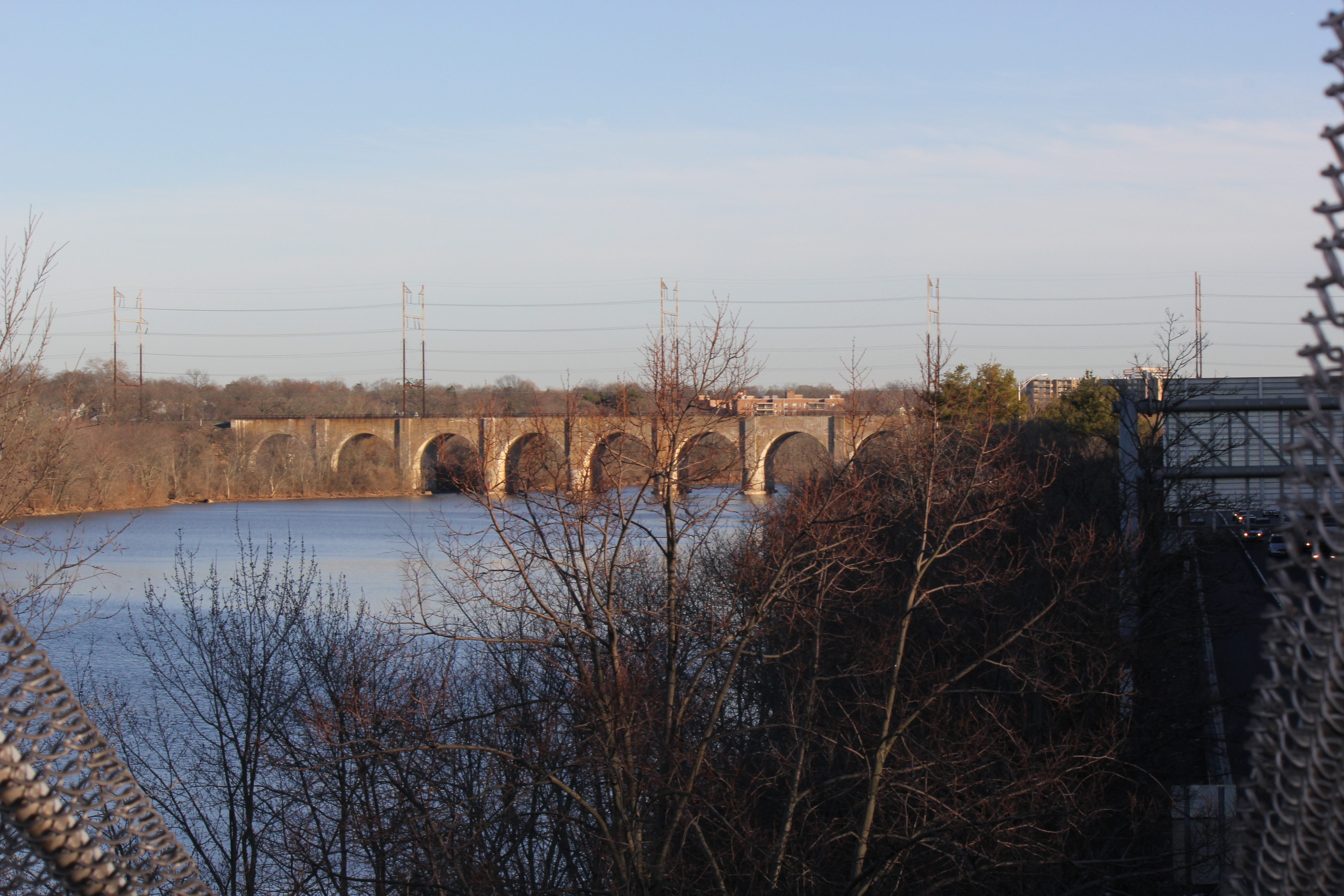
LOCATION: The Millstone and Raritan Rivers, Somerset and Middlesex Counties, New Jersey.
SUMMARY: The National Oceanic and Atmospheric Administration (NOAA) is the lead federal agency for National Environmental Policy Act (NEPA) compliance for projects brought forth to restore injured habitat for fish and other trust resources resulting from long-term hazardous substance releases from the American Cyanamid Co. Superfund Site in Bridgewater Township, New Jersey. Projects identified in the RP/EA are compensatory for lost resources and fulfill an obligation to serve the public as required under the Comprehensive Environmental Response, Compensation, and Liability Act of 1980 (CERCLA), also known as Superfund Law. Superfund is a United States federal law designed to clean up sites contaminated with hazardous substances and pollutants. The Draft RP/EA proposes removal of the Weston Mill Dam on the Millstone River as well as feasibility analysis and design of technical fish passage at the Island Farm Weir, located on the Raritan River.
As documented in the RP/EA, the selected projects are expected to have an overall beneficial impact on ecosystem function and species biodiversity. The project’s goals include benefits to various species, improvement of habitat function, and protection of existing habitat. Because the project is intended to restore natural resources, it is expected to cause a net increase to habitat productivity and improve ecosystem function.
INVITATION TO PUBLIC COMMENT: The National Oceanic and Atmospheric
Administration, the Department of Interior, and the State of New Jersey invite public comment on a proposed plan.
The Draft RP/EA is available at the following website: https://darrp.noaa.gov/hazardous-waste/american-cyanamid
The public comment period on this plan ends June 10, 2016.
One hard copy of the RP/EA will be available in each of the following public library locations:
Manville Public Library
Address: 100 S 10th Ave, Manville, NJ 08835
Phone: (908) 722-9722
Hours: Mon-Thurs 9:30AM–9PM
Friday-Sat 9:30AM–5PM
Franklin Township Public Library
Address: 485 Demott Ln, Franklin Township, NJ 08873
Phone: (732) 873-8700
Hours: Mon-Thurs 10AM–9PM
Fri-Sat 10AM–5PM
To request further information or an additional hard copy of this document or to submit your comments, please contact Carl Alderson at (732)371-0848, NOAA Restoration Center – Sandy Hook Office, JJ Howard National Marine Fisheries Science Center, 74 Magruder Rd, Highlands, NJ 07732 or by email at Carl.Alderson@noaa.gov. Please put “American Cyanamid Draft RP/EA” in the subject line.
From: www.nj.com “Community Bulletin”
The Somerset County Regional Center Partnership, utilizing a grant from the New Jersey Water Supply Authority (NJWSA), has announced that the 2016 Raritan River Rain Barrel Rebate Program for homeowners in Bridgewater, Raritan, and Somerville is accepting applications for the sixth year of the program.
The Rebate Program in intended to encourage residents to purchase and install rain barrels by offering rebates up to $200. Rebates are available in the amount of $50 for rain barrels that hold 40 to 70 gallons and $100 for those that hold more than 70 gallons. Rebates are available for multiple rain barrels that meet all criteria.
Residential homeowners within the Peters Brook Watershed who purchased and installed rain barrels after July 1, 2011 remain eligible for a rebate providing documentation is available. Residents outside the Watershed but within the boundaries of the three municipalities must have purchased the rain barrel after January 1, 2014. Sufficient documentation including proof of purchase and installation is required.
Rain barrels provide homeowners with financial and ecological advantages by conserving water, easing stream erosion by reducing the volume of runoff entering to streams and rivers during storms, and reducing pollutants accumulated from impervious surfaces, particularly roofs. In established urban areas like the Regional Center, rainwater runoff from hard surfaces flows directly into streams, depositing these pollutants.
Rain barrels must have a closed design or screen top; have a system to direct excess water away from the home’s foundation; have a spigot not higher that 3″ from the bottom of the barrel; and must be made of a sturdy material and installed on a solid level base. Homeowners must pledge to maintain the rain barrel for at least two years to be eligible for the rebate.
“A rain barrel is a simple and effective way of practicing environmental responsibility,” commented Troy Fischer, Chair of the Somerset County Regional Center Partnership. “Homeowners in the Regional Center communities have a unique opportunity to recoup their investment twice, once through the rebate and multiple times through re-use of rain water.”
Rebates will be awarded on a first come, first served basis, and funding is limited. Detailed information can be found on the Regional Center Partnership’s website at www.regionalcenterpartnership.org, by calling 908-730-0270 x223 or sending an email to rainbarrel@raritanbasin.org.
The Somerset County Park Commission is supporting the 2016 Rebate Program by including information on the web site, www.somersetcountyparks.org, and in kiosks and at special events throughout the County park system.
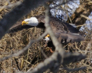
Article and photos by Joe Mish
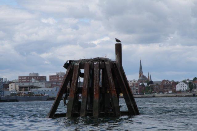
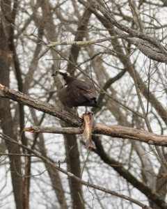
The osprey from Maine searches the clear water of the South Branch for a meal as she takes a break from her 2,500 mile journey north. The letters, DV, can be seen on the blue band attached to her right leg.
The warmth from the mid-morning sun felt good on my back as I paddled the low, clear water of the South Branch. The cloudless sky, directly above, was a darker shade of blue, its intensity pure and endless, and mesmerizing. It compelled me, as the devil’s advocate, to search for just a single speck to interrupt its perfection.
Suddenly a shadow sped across the water, momentarily stealing the sunlight. I instinctively looked up to catch a glimpse of an osprey circling above. The white head, streaked with a dark brown stripe, was instantly recognizable. The osprey proceeded downriver by making tight overlapping circles in its search for fish. It isn’t too hard to imagine some of these super intelligent predators realize a canoe is herding the fish ahead of it. When the osprey was about 150 yards downstream it tucked its wings and dove into foot deep water to come up with a large white sucker held fast in its black talons. The bird oriented the position of the fish to cut wind resistance as it flew out of sight.
Ospreys are ever present on the South Branch, typically from early spring to mid autumn. They feed primarily on live fish. I see them most often eating white suckers, a fish large enough to compensate for the energy spent to catch it.
Osprey on a riverside perch, dining on fresh fish during the 2014 NJ opening day of trout season.
Earlier this April, I noticed an osprey perched in the same location day after day. This wasn’t typical of the local ospreys that ranged far and wide in their constant search for food. I was able to get a few photos and noticed a blue band on the right leg and a silver band on the left. I reported the band to the USGS website, BandReports@usgs.gov, to find this osprey was banded in Portland, Maine, July 27th, 2011 while it was still in the nest, too young to fly.
Osprey migrate from the northeast, where they breed, to central and South America each fall, a trip of more than 2,500 miles. This bird was apparently on its way back to Maine and stopped to rest. Osprey, like other migratory birds, are very loyal to nest sites and return to the same location with great predictability.
Consider our visiting osprey will be 5 years old this July, and has 25,000 plus, frequent flyer miles on its account, you have to recoil in amazement, wonder and respect for its strength and tenacity. As osprey can live 25 to 30 years or more, the mileage really adds up.
Our Maine visitor, a female, as evidenced by her speckled décolletage, has a bright and long future and hopefully will stop along the South Branch again on her journey to and from Central America. No doubt other osprey are flying to northern breeding grounds through NJ, so the opportunity to spot a banded bird along the North and South Branch are quite good.
The reporting of banded birds is critical to wildlife research as it helps to unravel the mystery of migration, the location of breeding grounds, longevity, and other variables that impact the health and status of local and overall wildlife populations.
New Jersey is now using red bands for osprey and from Ben Wurst at conservewildlifenj.org, as per USGS; “Green anodized bands are being used in NY. Purple anodized bands in MD and VA. Red anodized bands (like ours, but with alpha code A&B 00-99) in PA (permit is expired now). Blue anodized bands in MA, ME & Ontario.”
The preponderance of osprey nests in NJ are along the Delaware River and Atlantic shoreline, its estuaries, bays and rivers, so keep an eye out for banded birds and report them to BandReports@usgs.gov . The researchers are as excited about a band report as you and will send a certificate of appreciation with relevant data about your bird. Many species of birds are banded, so don’t forget our eagles, hawks and songbirds. Opportunities abound as NJ is on a major flyway, the rivers being main exit and entrance ramps to our backyard.

*Joe sent us an update to this post, a photo of the exact location in Maine where the osprey was born. Photo courtesy of Lauren Gilpatrick at the Biodiversity Research Institute, Portland Maine.
See, http://www.conservewildlifenj.org/education/ospreycam/ for more details about NJ osprey project and live osprey cam.
Special thanks to Robert Somes, Kathy Clark and Ben Wurst for their enthusiastic help and support.
Robert Somes, Senior Zoologist
NJ Division of Fish and Wildlife
Endangered and Nongame Species Program
Kathy Clark,CWB,
NJ Division of Fish and Wildlife
Endangered and Nongame Species Program,
Ben Wurst, Habitat Program Manager
New Jersey Osprey Project
Author Joe Mish has been running wild in New Jersey since childhood when he found ways to escape his mother’s watchful eyes. He continues to trek the swamps, rivers and thickets seeking to share, with the residents and visitors, all of the state’s natural beauty hidden within full view. To read more of his writing and view more of his gorgeous photographs visit Winter Bear Rising, his wordpress blog. Joe’s series “Nature on the Raritan, Hidden in Plain View” runs monthly as part of the LRWP “Voices of the Watershed” series. Writing and photos used with permission from the author.
Article and photos by Joe Mish

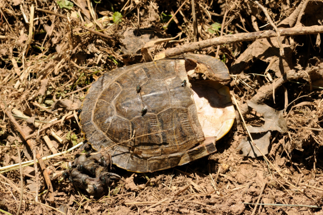
A slow journey that began more than a million years before, ended at the tip of a mower blade spinning at 3,200 rpm. This wood turtle, listed as ‘threatened’ in New Jersey, was killed in late May, while on its way to lay eggs.
May and June have been the peak of the great turtle migration where females, laden with eggs, leave the protection of quiet places to journey far and wide to dig holes and bury their eggs. Incubation takes about 70 days, more or less, and nests are left unattended.
All species, whether aquatic, terrestrial or both, like the wood turtle, seek dry land to lay eggs. Each has a preference for where and when they dig nests, though individual variation is the rule.
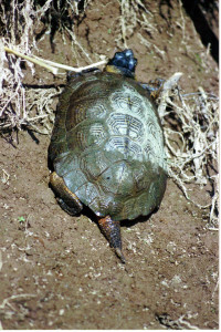
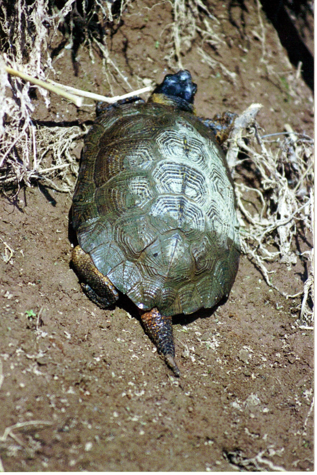
A wood turtle on its way out of the river where it hibernated to lay eggs in the gravel soil near railroad tracks.
Wood turtles prefer gravel laden soil on high ground, as found along railroad tracks, roadsides and driveways.
Roadways have become the killing fields for these slow moving reptiles where large blocks of undisturbed habitat are segmented by roads. A preserved island of land may be celebrated as a conservation success but the lack of linear greenways to bridge these islands is a death knell for many small creatures as it exposes them to predation and roadkill.

Eastern box turtle pauses mid journey across a New Jersey roadway, in a false retreat that offers no protection form speeding vehicles.
Turtles are creatures of habit and maintain consistent pathways from year to year. So that eastern box turtle you saw crossing over the double yellow line last year will be crossing the road in the same place this nesting season.
Mowing tall grass during nesting season is a more insidious cause of death for turtles and grassland nesting birds. Many farmers and landowners alter their mowing schedule to prevent killing fawns and game birds; turtles and grassland nesting birds are coincidental beneficiaries.
State conservation organizations advocate mowing early in the season and then not again until August, late July at the earliest.
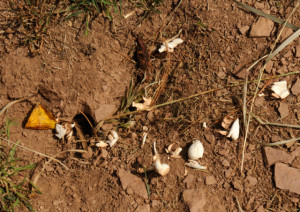
A driver may possibly avoid killing a turtle on a paved road as it is somewhat visible, while a turtle in tall grass is a foregone conclusion when a mower runs through a field. The fractured shell of the wood turtle pictured, was found on a path mowed through an overgrown pasture near the South Branch.
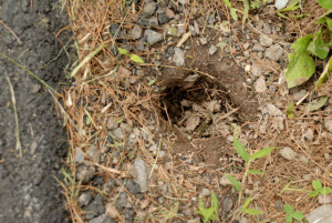
Females may travel half a mile from wet areas to lay eggs, so please be careful. As the wood turtle is considered, “threatened “, and known to populate our area, special caution should be taken. May 29, 2015, a female wood turtle was observed digging a nest within inches of a long paved private drive, in hard packed gravel. This would be the last place you’d ever expect a turtle to dig, as you would be hard pressed with a pick and shovel to penetrate that ground. The hole was about 5 inches deep and 4 inches wide.
An awareness of turtles and their nest sites are a prerequisite to protecting them. As the eggs are laid in a small hole, covered and left unattended, you’d never know you were endangering a nest. Many eggs don’t hatch or are destroyed by predators. Then imagine an inch long hatchling trying to traverse a quarter mile through fields and open ground in an effort to reach water, bog or swamp. Survivors are few and far between.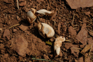
…you will find collapsed leathery egg shells scattered about; though they won’t look like egg shells. Imagine an egg shell make of cloth and inwardly collapsed to appear as a scrap of white material.
With poor odds for survival, it begs at least awareness on our part to, “first, do no harm”, and avoid destroying nests or mulching hatchlings and adults with a mower.
Turtles remain in their essential form that traces back to prehistoric times. Their evolution is an unrivaled success, even more astounding when their slow lumbering movements and low reproduction rate are considered.
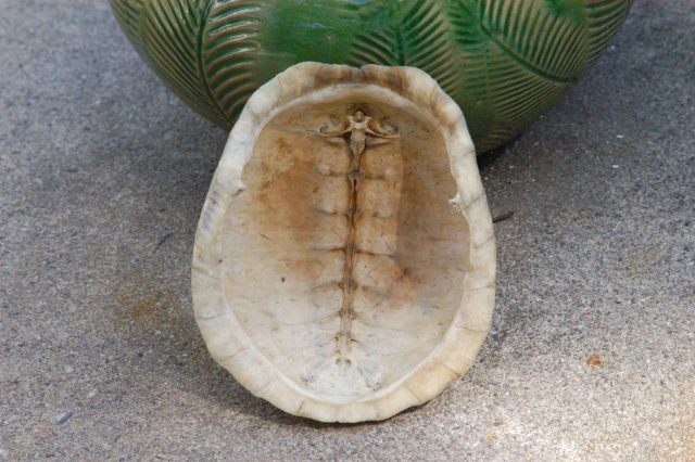
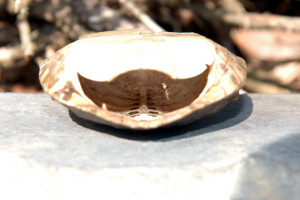
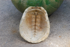
Some interesting anatomical features reveal the secrets hidden behind the shell. See how the spinal cord is integral to the carapace or top shell in this painted turtle. The box turtle shell shows the spine as well as the clavicle. The thin plates that line the outer surface of the shell are attached much like a fingernail.
The easiest way to find a turtle nest is to look for the open holes in late summer and early fall. Either the nests were naturally opened by emerging turtlettes or dug out by raiding predators. In either case you will find collapsed leathery egg shells scattered about; though they won’t look like egg shells. Imagine an egg shell make of cloth and inwardly collapsed to appear as a scrap of white material. Last year I found 6 nests, one, just outside my back door. I had never seen a nest before but once I knew what to look for, they seemed to be everywhere.

The Unami, one of the three matrilineal clans of the Lenape indians, who lived in central New Jersey, were known as the Turtle Clan. Treating the turtle with respect, keeps the clan of the turtle alive and well in the land it has known since the last glaciers receded and the land emerged from the sea. Consider, the turtle had arrived at it final evolutionary form long before humans. As new to the neighborhood, we might look to the turtle for guidance as we would a centenarian, to seek advice on how to live a long life in alignment and peace with our ever changing environment.
Author Joe Mish has been running wild in New Jersey since childhood when he found ways to escape his mother’s watchful eyes. He continues to trek the swamps, rivers and thickets seeking to share, with the residents and visitors, all of the state’s natural beauty hidden within full view. To read more of his writing and view more of his gorgeous photographs visit Winter Bear Rising, hiswordpress blog. Writing and photos used with permission from the author.
The LRWP is excited to be a part of “Citizen Science Monitoring for Pathogen Indicators in the NY-NJ Harbor” – a grant secured by NY-NJ Baykeeper to monitor local waters for pathogens in Raritan Bay. Funding for training and sample analysis is provided by the NY-NJ Harbor Estuary Program. Volunteers are needed for summer monitoring, with training to start in May.
Volunteer civic scientists from the LRWP and Bayshore Regional Watershed Council will help the NY-NJ Baykeeper collect water samples this summer at sites along the shores of Raritan Bay & Sandy Hook Bay. The LRWP and Raritan Riverkeeper will coordinate sampling at the three sites in Perth Amboy identified in this map. Bayshore Regional will cover the remaining sites. Training will start in May and will involve field, lab and data management procedures. We will follow strict quality assurance and quality control procedures approved by the U.S. Environmental Protection Agency (EPA).
Our goals with this project are to generate high quality, credible data on the health of our waterways, suitable for a wide variety of users. This information can help government agencies and the public make decisions about water quality improvements, habitat restoration, and recreational use. Volunteer monitors will gain important science skills and experiences while strengthening their connection with, and care of, local resources.
We need volunteers (YOU!!!) to help. Do you have time this summer to collect water samples so we can learn about our River? Do you want to gain a new perspective on the Raritan and have a lot of fun? Do you want to take your environmental stewardship to a new level?
To volunteer please e-mail Heather hfenyk AT lowerraritanwatershed DOT org
(This opportunity is an especially good resume builder – perfect for college students!)
By Elizabeth Dabundo, LRWP Green Infrastructure & Planning Intern
In the first of the LRWP’s Natural Asset Mapping speaker series we hosted two wonderful speakers, JeanMarie Hartman and Jessica Jahre, on the topics of the importance of riparian areas and floodplains.
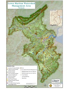
Wetlands of the Lower Raritan Watershed, Map by Jeanine Kopec-Zanghi
Rutgers Professor JeanMarie Hartman, Director of the Hartman Lab of Watershed Systems Studies, spoke on the importance of preserving riparian areas around streams as “buffer zones” for stream and habitat protection. She explained that the best type of “green infrastructure” for flood protection is the kind that doesn’t have to be engineered or installed – it is the natural “infrastructure” already found in forests and wetlands. It is best to keep a 300-foot buffer zone around streams in order to keep the stream itself, its inhabitants, and the surrounding watershed healthy. Professor Hartman explained these conclusions as almost common sense, but provided findings from an ongoing study of watershed management in Lower Raritan Watershed streams (Bound Brook and Lawrence Brook) that demonstrate a positive relationship between forest and wetland cover and biological water quality.
The study measured the presence of three groups of macroinvertebrates (aquatic animals) in the streams to determine stream health. Certain macroinvertebrates are more or less sensitive to environmental pollutants, and they can be grouped thusly:
-Pollution Intolerant (mayflies, stoneflies, caddisflies)
-Pollution Sensitive (dragonflies, damselflies)
-Pollution Tolerant (aquatic worms, midge larvae)
The presence of more pollution intolerant or pollution sensitive macros in a stream signifies that the stream and its waters are unimpaired, since they cannot live within polluted waters. These are often found in shaded streams with low levels of fine sediments, which not surprisingly are often streams with significant riparian buffers.
Next, Jessica Jahre of Princeton Hydro spoke on the importance of healthy floodplains. Floodplains are the areas surrounding streams and rivers that flood periodically, relating to risk. We often hear of 100-year or 500-year floods, but recently, we have seen more frequent and more intense flooding in the Lower Raritan Watershed. Floodplains are expanding, and more people are being put at risk for residing in or near the floodplain. Ms. Jahre explained that a healthy floodplain is integral for mitigating flood risk and damage in our communities, and she explained how she works with flood claims data to identify the areas most at risk.
It is important for a floodplain to be healthy in order to not only reduce instances of flooding, but also to improve water quality, recharge aquifers, and create wildlife habitat. It is often the case that floodplains have to be enhanced from current degraded conditions. This process includes reforesting or naturalizing (removal of development) floodplains, reconnecting the stream to the floodplain, lowering the floodplain through re-grading, or hydrologic restoration (eliminating abandoned agricultural ditches, removing dams). The problem we face in New Jersey and in many other densely populated areas is that development often comes right up to or is centered around rivers or streams, which only become more prone to flooding as the floodplain becomes more impaired through development and deforestation. In order to minimize future risks from flooding, we must enhance and improve our floodplains statewide.
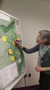
Susan Edmunds identifying riparian areas of interest
Thank you to our wonderful speakers and attendees. Next up in the speaker series are presentations on Lower Raritan Watershed recreational assets and neighborhood, cultural, and historic assets. Please join us on March 15 from 9:30am-12:00pm at the Middlesex County Administration Building, 75 Bayard Street, New Brunswick.
Speaker themes for 2016 include natural resource assets, cultural and historic assets, transportation and mobility assets, seeing brownfields as community assets for restoration, and economic assets, innovation, & regional planning. We are very excited for the opportunity to have state and regional experts on these topics join us for these presentations, and we hope you will join us as well! Please see our events page for more information.
by Maya Fenyk (age 11), LRWP youth consultant and “Endangered & Threatened Species” series contributor
Hello! I am Myosis Sodalis, but you can call me Clementine the Indiana Bat. I am an endangered species, which means that I am likely to become extinct. Because of my endangered status, my habitat is considered “critical.” This means that special efforts are supposed to be taken to protect the important characteristics of where I live. I live in caves and roosts throughout the central part of the United States and the East Coast, including parts of New Jersey and the Lower Raritan Watershed.
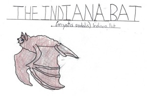
Clementine, the Indiana Bat (drawing by Maya Fenyk)
Some people are scared of me (and of bats in general), but they shouldn’t be. Bats do a lot of work for humans! We are great at pest control, pollination and spreading seeds. Farmers especially appreciate what we do. And if you think about how many pesky mosquitos we eat every night you will start to appreciate us, too! Even though we help out in so many ways there are a lot of issues that make it hard for me and my friends to survive and to do our important jobs. There are lots of threats to our survival – like development near caves and old mines (the places that we stay during hibernation), deforestation of our summer roosts, the use of pesticides, and White Nose Syndrome (WNS). WNS is really scary – it is a fungus that grows on our bodies that leads to starvation and to our freezing to death. Did you know that there are things that YOU can do to help protect me and my habitat? There are things you can do that will make it so that my friends and I can survive and continue to do the pest removal and farming work that helps you humans out!
Before I tell you how you can help out, you should first know a few things about me, like where I live and what I look like. I’m a relatively small bat, only 3.5 inches long. But I have a ginormous wingspan of 10.5 inches! I have black eyes, big ears, a pink nose and very short toe hairs. I also have very strong ridged calcar (the cartilage between my wing joints). I really like to find secret and protected areas to stay with the rest of my maternity colony during the winter months. The maternity colonies – in abandoned mines or caves – are wonderful happy places. I have a lot of friends there. I’m a mommy bat, and the other mommy bats and I work together to keep our babies safe and fed. Unfortunately, over the years a lot of development near caves and old mines has made it really hard for me and my friends to meet together in the large mines or caves that allow us to share the protections of maternity colonies. This means that I often have to find isolated caves to live in, and when I go out to hunt food I have to leave my babies alone without my friends to help me watch over them. As a result my babies end up as easy prey for predators including snakes, owls and raccoons. Development has also affected our summer habitat.
When my kids become juveniles they need time outside of the cave to mature and to learn to hunt bugs and to live on their own. But deforestation and removal of our trees has led to fewer and fewer places for us to safely spend our summers. I do have one favorite summer home on the banks of the Raritan River in New Brunswick – I know that there are protections in place there that keep municipal maintenance crews out of my home during the crucial summer months. Thanks to attention to state laws no one comes in to bother me and my kids!

Indiana Bat Habitat in New Brunswick, NJ (image: Heather Fenyk)
Even though we might not have humans coming directly into our summer homes we still have to deal with poisoned food. That’s right – the White Nose Syndrome I told you about is most directly linked to eating bugs that are sick from pesticides that you humans put on your fields and lawns. WNS creates a fungus that makes my hair fall out, and that covers my nose and makes it hard to eat. And when my hair falls out I might freeze during the winter! Other ways that WNS is spread is by coming into contact with gear that humans carry from cave to cave when they explore our homes.
There are things that you can do to help protect me. These include protecting my habitat, including my winter and summer roosts. My summer roost is in the inside of a dead oak so it is very important that you don’t cut down dead trees unless they are diseased. Not only could that decomposing tree in your backyard be MY home, it is also important to the health of the soil to have the decomposing plant matter enrich the soil. And keep my summer roost clean! But only clean-up during winter months (November through March) so you don’t disturb me while I’m roosting. Please respect my winter roost, too. My pups are experiencing their first hibernacula in our winter roost – a cave. My pups are trying to conserve energy for when it becomes warmer and are very vulnerable if I have to go out to hunt for bugs to feed them. You should know not to come into my cave, and if you do at least clean your gear before you do because WNS can be spread from cave to cave on the gear of humans.
Please clean up my habitat! (Image: Heather Fenyk)
Other ways you can help save my species is to stop using pesticides in your garden, stop cutting down trees and leave the wild as it should be. It’s great to meet you – please look for me at twilight when I’m out hunting bugs. The Lower Raritan Watershed is an especially good place to find me during the summers – it is the middle ground for my long range from Michigan to North Carolina. And if you see me or any of my friends please contact the Lower Raritan Watershed Partnership to let them know. They are working to document Indiana Bat sightings to help to protect our habitat. Now please excuse me. I must go prepare to move for it is the time of year where we are readying our juveniles to head to our summer roost. Clementine the Indiana Bat signing off!
Articles and Photos by Joe Mish

A cooper’s hawk flies off after landing in a holly tree where it jumped from branch to branch in an effort to flush a hiding songbird into the open.
Midwinter is a great time to catch a glimpse of local wildlife, especially hawks, as these large birds stand in dramatic contrast to the gray-brown leafless trees in which they perch.
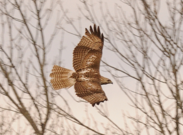
The most common hawk in our region is the red-tailed hawk. Comparatively large, the adults are recognized by the bright russet colored tail. This is the only hawk whose tail is not banded or bordered by a contrasting color. The young birds have barred tail feathers, alternating russet and white, with no distinct borders.

Easy to spot at highway speeds, the light breast and faded red tail stand out like a beacon when perched in trees along the roadway. Locally, I often see these hawks atop telephone poles near pastures and flood plains where they scan the open area for small mammals and ducks. Some red tails specialize in killing gray squirrels, a worthy meal for such a large bird whose energy expenditure in the winter would hardly be covered with mice or voles.
During a winter freeze when most of the river is solid ice, there are always open sections where ducks concentrate in the water and on the ice. A red tail will make an easy meal, especially of the smaller wood duck, flushing it into the air or catching it as it naps on the ice.
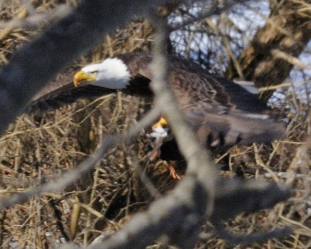
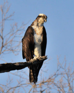
Last winter I watched an eagle feeding on a wood duck, speculation was the eagle took the duck from a red tail as eagles are notorious for stealing game from ospreys and hawks.
Muskrats are also high on the midwinter menu as the males often travel during the day over ice and snow as they seek food and females to breed.
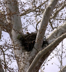
A hawk requires a large nest and now is the time to scan the treetops and high tension towers for these stick built structures. One local hawk has adapted to a giant oak in someone’s backyard bordering a cluster of recently constructed homes. I have seen several local nests situated high in sycamore trees along the river. Hawk nests are relatively flat and large, not to be confused with squirrel nests which are numerous and quite round, generally built at a lower level, among thinner branches. Red tails will also use ledges as a base for their nests.
The ultimate adaptation belongs to the red tail known as, Pale Male, whose life is well documented in film, media and print as he has mated and bred several generations of hawks among the skyscrapers in mid Manhattan. His age is estimated at 24 years. Here is one site dedicated to Pale Male.
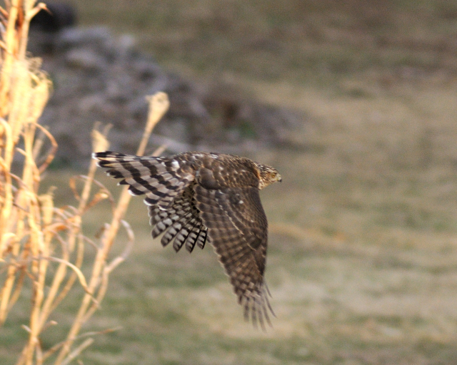
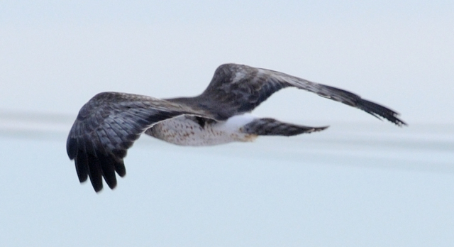
Marsh hawks share the sky with red tails and characteristically conduct ground hugging flights across overgrown fields, flood plains and grasslands and have an ability to hover in place. These hawks are slightly smaller than a red tail with dark brown coloration and a boldly banded tail. The key to identifying a marsh hawk is the bright white rump patch. These hawks are common, though not often seen and are known to migrate while red tails remain as full time residents.
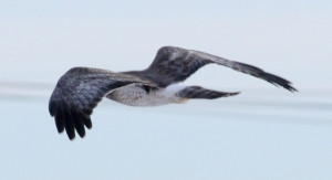
Aside from red tails, the most often seen hawks are the coopers and sharp-shinned hawks. The coopers being slightly larger than the sharp shinned. Both hawks feed on songbirds and small rodents. As each is similarly marked, identification is always controversial. More often than not, someone will submit a photo of a hawk to a website asking if it is a coopers or sharp-shinned and the replies are often split, each summarizing why they made their choice. I see the larger coopers preferring doves and rabbits while the sharp shinned has left piles of bluebird, indigo bunting and flicker feathers about the yard.
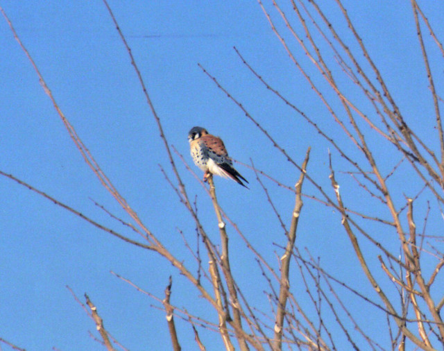
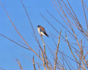
Lastly, look for the diminutive sparrow hawk, now known as the kestrel, typically perched on telephone poles and wires along open fields. This bird is about the size of a large dove, feeds on insects and small rodents. Kestrels are known for hovering before they dive on their prey and this stationary flight is a good identifying characteristic. The males are brilliantly marked with blue, shades of russet, black and white. At first glance a perched kestrel will appear as a songbird so be sure to give a second look. They are considered threatened in New Jersey and a nest box program and monitoring effort is having a positive effect on their recovery. The birds are easily baited and trapped for tagging and data collection.
This is the winter of the hawk and hardly a commute is possible without being evaluated by a feathered predator. They can see you, can you see them?
Author Joe Mish has been running wild in New Jersey since childhood when he found ways to escape his mother’s watchful eyes. He continues to trek the swamps, rivers and thickets seeking to share, with the residents and visitors, all of the state’s natural beauty hidden within full view. To read more of his writing and view more of his gorgeous photographs visit Winter Bear Rising, his wordpress blog. Writing and photos used with permission from the author.
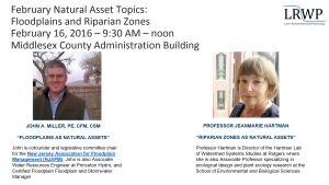
by Heather Fenyk & Elizabeth Dabundo
Join the LRWP from 9-noon on February 16th when we will hear presentations on Natural Resource Assets by John A, Miller, Princeton Hydro Water Resources Engineer and co-founder and legislative committee chair for the New Jersey Association for Floodplain Management and Rutgers Professor JeanMarie Hartman, Director of the Hartman Lab of Watershed Systems Studies at Rutgers.
Natural Assets Map Project Background
In February 2015 at a workshop on Impervious Cover Remediation (ICR) co-hosted by the LRWP and Rutgers Cooperative Extension Water Resources, the LRWP recognized a need for tools to help communities implement Green Infrastructure (GI) and meet ICR goals. At the ICR workshop municipal representatives expressed an interest in minimizing stormwater runoff, with many of of these reps suggesting that their communities set impervious cover reduction targets. But where to start? How could towns best prioritize resources for ICR and GI implementation?
To help LRW communities on this path the LRWP researched tools that would help with strategic location of ICR and GI sites. We found references to a process called “Natural Assets Mapping” that suggests not only a prioritization process, but also provides an approach to orienting community conversations around valuation of ecosystem services and the benefits supplied to human societies by natural ecosystems.
Working with input from the Middlesex County Department of Planning we shaped a speaker series for 2016 to guide development of a Natural Assets Map for the Lower Raritan Watershed (Watershed Management Area 9), and to prime municipal conversations regarding prioritization of GI and ICR.
Our goals for the project include:
- To evaluate, prioritize and map natural and cultural assets in the Lower Raritan Watershed.
2. To support community stewardship of Green Infrastructure (GI) / Nature-Based Solutions, including:
-Informing development of GI Master Plans
-Identifying opportunities to add GI to capital projects
-Helping communities link to GI performance rates
-Helping develop design standards for GI related to identified assets.
3. To identify potential investments to optimize the existing system.
4. To advance and support stormwater management planning at County / municipal levels.
5. To improve administration of environmentalism in the LRW.
The 2016 Natural Assets Mapping kick-off
At the 2016 Natural Assets Mapping kick-off event on Tuesday January 26, LRWP Land Use Planner Angela Knowles gave an overview of the Natural Assets Mapping process as outlined by Karen Firehock at the University of Virginia. Angela provided highlights of the document we are using to guide our work (“Evaluating and Conserving Green Infrastructure Across the Landscape: A Practitioner’s Guide“) and described the various GIS layers the LRWP plans to discuss going forward.
Angela also explained how, using these layers, we will map environmental, cultural, historic, and human assets throughout the watershed in an interdisciplinary way. With GIS, LRWP communities will be able to see where particular features are found, what geographical patterns exist, and what changes have occurred over a given time period. We aim to identify the natural assets in the watershed and how they relate to other community assets so that we can conserve, and/or restore the natural features that are most valuable to communities. This further reduces the need to build engineered structures to deal with issues like stormwater runoff in favor of more cost effective, natural solutions.
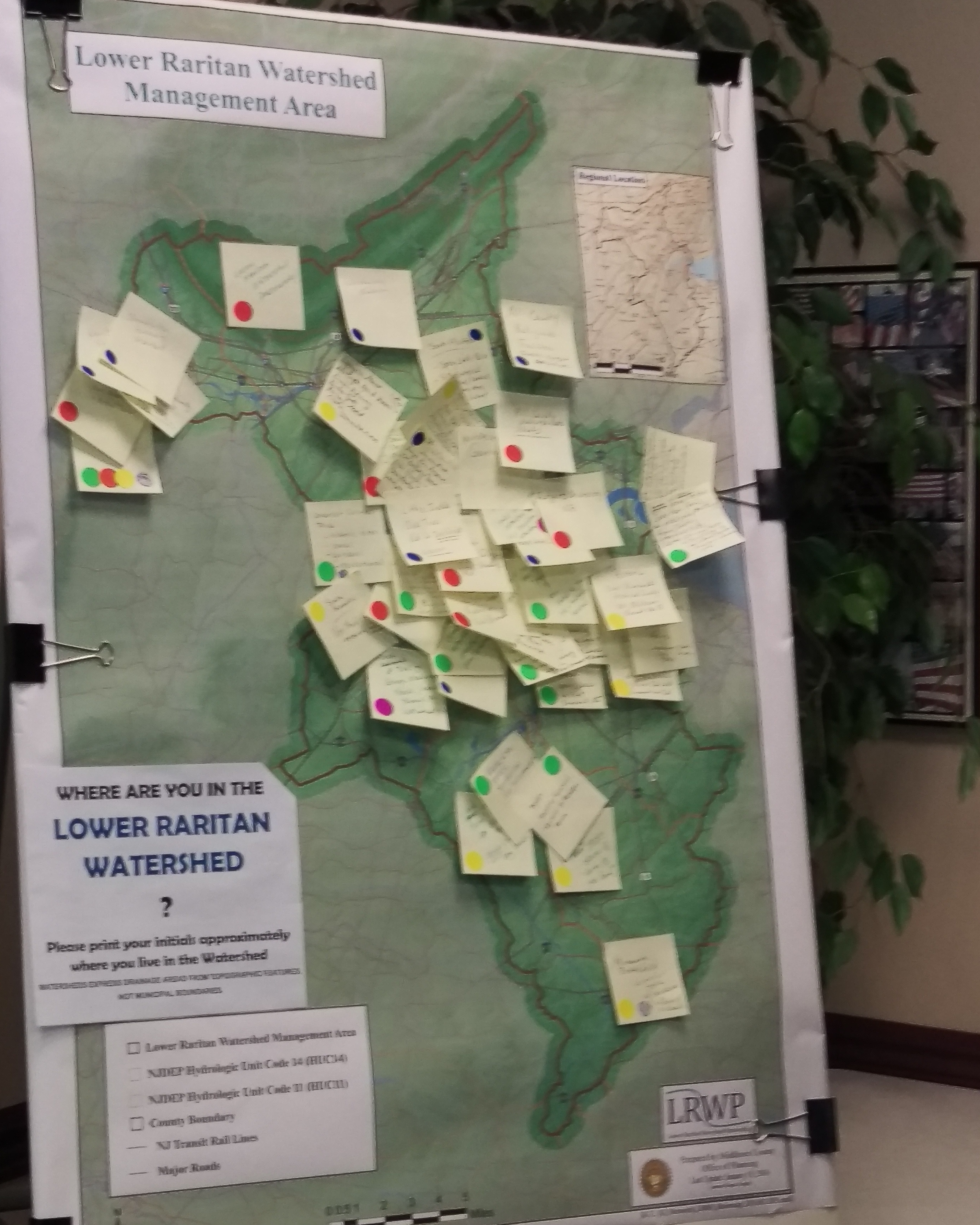
At the kick-off, attendees brought attention to various environmental, cultural, historic, and human assets that they personally thought were valuable in a group mapping exercise. The LRWP will devote much of the year to reaching out to community members around the LRW to pinpoint certain areas that may be less known to many, but no less valuable.

Speaker themes for 2016 include natural resource assets, cultural and historic assets, transportation and mobility assets, seeing brownfields as community assets for restoration, and economic assets, innovation, & regional planning. We are very excited for the opportunity to have state and regional experts on these topics join us for these presentations, and we hope you will join us as well! Please see our events page for more information.
The LRWP thanks Professor Lathrop, the newly-appointed Johnson Family Chair in Water Resources and Watershed Ecology at Rutgers University, for sharing his vision for how Rutgers can provide academic leadership to improve the health of the Raritan River. For more information about the Johnson Family Chair and Professor Lathrop’s new position please see the Rutgers Today Press Release.
By Richard G. Lathrop Jr.
Modern society is increasingly coming to recognize water as a critical resource, on a par with oil and gas. Water scarcity, whether due to prolonged drought, political instability, regional conflict or any combination of the above, is at a crisis stage on the US West Coast, across the Middle East and elsewhere around the globe. Point sources of water contamination or more diffuse sources of pollution related to urban, suburban or agricultural land uses is also of increasing concern. Ensuring access to clean and abundant water to sustain both human society and healthy ecosystems over the 21st century will require a concerted effort on the part of government, academic, private and non-profit sectors. From an academic standpoint, addressing this challenge will require not only an interdisciplinary approach bridging the social, political and natural sciences but also a watershed perspective that links the land surface to downstream aquatic systems. The Johnson Family Chair in Water Resources and Watershed Ecology is intended to undergird such an effort here at Rutgers University.
In the heart of the most densely populated region in the nation, the Raritan River Watershed serves as a “natural laboratory” to study how human actions and policies both negatively and positively affect ecological health of a watershed system. One of my major focal areas as Johnson Family Chair will be co-leading the Sustainable Raritan River Initiative (SRRI). The objective of the SRRI is to work with various stakeholders in the watershed to balance social, economic and environmental objectives towards the common goal of restoring the Raritan River, its tributaries and its estuary for current and future generations. Since the founding of the SRRI in 2009, the Edward J. Bloustein School of Planning and Public Policy has provided academic leadership in the policy realm and the School of Environmental and Biological Sciences in the scientific realm. The SRRI in turn partners with the Sustainable Raritan River Collaborative (SRRC) representing a network of over 130 organizations, governmental entities and businesses in the Raritan River Basin. As Johnson Family Chair, I will provide strong scientific leadership to chart SRRI’s future direction and ensure that issues of critical significance to the Raritan watershed are addressed. In addition to my own research, I will coordinate with various individual scientists, departments and research centers to make sure that Rutgers University’s scientific and technical expertise is brought to bear. Working in concert, we should be able to achieve tangible results towards restoring the Raritan River and Bay to a vibrant and biologically diverse ecosystem for the benefit of present and future citizens of the state and region. Further, the lessons learned from the science and policy research conducted under SRRI’s rubric will transcend the local environs and have relevance elsewhere in the United States, as well as globally.
Within the University, as the Johnson Family Chair I will play a key role in developing and promoting an academic agenda centered on the Raritan River and its watershed. Such an academic agenda will seek to engage a variety of curricula, both on- and off-campus, to make greater use of the Raritan River and the Rutgers Ecological Preserve as part of their educational program. These places provide experiential learning sites where students can observe and collect data as well as get their “hands dirty” by undertaking experimental manipulations and be involved in hands-on restoration and enhancement, design or arts projects. Within the EcoPreserve or on the Raritan, students can put into practice classroom or online learning in a real world environment. These field experiences will be coupled with advanced information technology to integrate field data collection with real-time sensor networks and geospatial information systems to make the EcoPreserve and the River a natural classroom as well as a living laboratory. One great advantage of the EcoPreserve and the River is that they are right on campus and accessible to students via the campus bus system; thus making their use for instructional purposes both time and cost effective. While our alma mater celebrates the University’s location “on the banks of the old Raritan” the University does not have ready access to the river proper. To help rectify this situation, the Chair will spearhead a feasibility study for the development of a Raritan River Watershed teaching/research field facility to be able to bring classes to and out on the water.
The Rutgers New Brunswick-Piscataway campus is blessed to have 400 acres of open space right at its very core, the Rutgers Ecological Preserve and Natural Teaching Area. As Johnson Family Chair, I will serve as Faculty Director of the Ecological Preserve, building on past success to further integrate the EcoPreserve into the life of the University and the surrounding community. As outlined above, the University has the opportunity to build a world-class educational program around the EcoPreserve and lead the United States in the academic pursuit of natural areas/open space stewardship, ecological restoration and leadership training. As the “voice” for the EcoPreserve as the University moves towards implementing the recently announced Physical Master Plan, I will strive to ensure that the role of the EcoPreserve to enhance student instruction and community quality of life is more fully realized.
Personal Background: Richard G. Lathrop Jr.
I have 25+ years of experience working with a diverse array of federal, state, and local government agencies and non-governmental organizations (NGOs) including watershed associations, land trusts, environmental NGOs, federal and state environmental agencies, and regional land/ocean management agencies. My interaction with these various groups has been to integrate insights from ecology and geography with the application of geo-spatial information science and technology to provide a “big picture” view that spans from an individual wetland or forest to the watershed to multi-state regions. More specifically, I have focused on measuring and modeling the how human land use activities and natural habitat change in the watershed affect downstream aquatic and estuarine structure and function. For example, as part of the Barnegat Bay National Estuary Program, I have been investigating the spatial and temporal dynamics of salt marshes and seagrass beds, both key nursery habitats for a number of commercially important fish and shellfish species, as key indicators of estuarine health. Working with the above partners, I have attempted to translate that understanding into effective and appropriate approaches and policies to improve natural resource management and land use planning. For example, in collaboration with the Nature Conservancy and other local partners, we have created the Restoration Explorer, an online tool that provides communities with a simple way to visualize where beneficial coastal restoration and enhancement projects are most appropriate based on ecological and engineering data. In my work, I have on multiple occasions assembled and lead multi-disciplinary teams to address water resources and watershed ecological issues. While much of my work has been conducted using New Jersey and MidAtlantic case studies, the implications of this research are relevant much more broadly, to elsewhere in the United States, as well as globally.
In 2009, Dean Robert Goodman appointed me as Faculty Director of the Rutgers Ecological Preserve with the charge to actively promote its teaching, research, active/passive recreation, and resource protection mission. I sought this position as a means to further my understanding of ‘on-the-ground’ natural resource management by being engaged personally in managing and restoring this 400 acre property, as well as an opportunity to further student engagement in learning and appreciation of the natural environment.
During my tenure:1) use of the Preserve has increased for academic purposes though a range of formal and informal instructional activities engaging middle and high school (including underserved youth), undergraduate, graduate and ROTC students; 2) use has increased for student research projects investigating such topics as the dispersal and control of invasive plants; 3) service learning opportunities have been provided to Rutgers courses (Principles of Natural Resource Management) and clubs (RU Outdoors Club, Naturalist Club) and outside groups (4-H, middle-high school environmental clubs); 4) natural resource values have been promoted though proactive meadow management, deer population control, riparian zone restoration, and wildlife habitat enhancements; 5) a forest vegetation inventory undertaken to provide a baseline on the forest community composition and health; 6) access has been increased by developing an extensive (7.5 miles), well maintained trail system and the opening up a new trailhead on Livingston campus; and 7) outdoor recreational opportunities have been enhanced through organized events that accommodate hundreds of participants (RU Muddy, Run for the Woods, Orienteering meets).
In closing, I grew up in the Raritan River Watershed and have lived 40 of my 56 years here. I hike its woods, paddle its waters and observe its wildlife. Thus I am personally invested in making the Raritan River Watershed a better place to live for its human inhabitants as well as its flora and fauna.