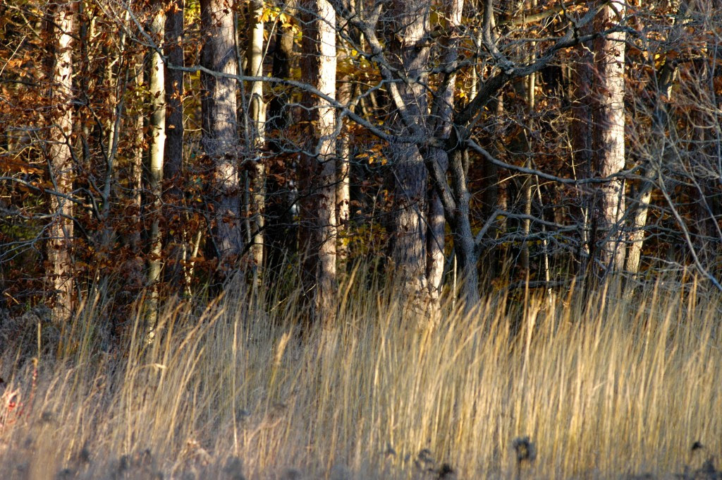
Champagne colored grass borders the dense forest, a scene which begs the question, Who lives in these woods so well kept?Open woods, where shadows hide from the moon and dance in the cold wind.
The natural progression of fall color fades in the late November woodlands, leaving amber-tan islands of American beech groves to stand as lighted guideposts against the bare, dark brown wooded landscape.
The vast track of mature woodlands had been cut for lumber over the centuries; old property lines defined by the maturity of the trees. The major species harvested over the last century has been tulip poplar, also known as yellow poplar which grows tall and straight. Non targeted species like sugar maple, shagbark hickory, green and white ash had a chance to vie with the fast-growing prolific tulip poplars in a race for sunlight when the dense canopy was removed by timber harvesting. The sunlight also allowed understory trees and shrubs to get established and proliferate to further define natural events, timbering and property lines.
Dogwood, various viburnums like arrowwood and ninebark, spice bush and witch hazel pioneered the new sunlit spaces.
Walking through the dark pre-dawn woods, I once came across an isolated grassy patch among the tall trees which produced a loud metallic rattle as if I stepped on some long forgotten wire fencing or tripped on a baby’s toy rattle. I thought the sound to be unnatural, its source hidden in the darkness, was loud enough to startle me and betray my presence in the quiet woods. Later I identified the plant as a rattlebox, a plant known to thrive in disturbed soil and pasture edge. So here was evidence that this tall timber was once in pastureland. The rattlebox became another signpost for me as I travelled the big woods.
While the initial dark encounter with the rattlebox suggested an unnatural origin, the fresh yellow blooms of the witch hazel appearing in November surely fires the imagination as it demands an explanation easily satisfied by myth. The name, ‘witch’, is a leading clue to make a lone traveler uneasy and unsure of his path. Witch hazel a native plant, was used as a medicinal by early cultures and a dowsing rod by later generations. Drug stores like CVS still carry witch hazel, most of it produced in Connecticut by the TN Dickinson company, a family branch of the original EE Dickinson company. The small yellow blooms of witch hazel stand out a like a cluster of decorative lights to contrast against the stark bare woods. The color is bright enough to be easily seen in the dark, and moonlit nights.
Spicebush is another color bearer providing the November woods with festive red berries quickly consumed by wildlife, especially migrating birds. Spicebush is an aromatic giving off strong citrus scent and does best in damp woods as an understory species. When ruffed grouse were plentiful, I once watched a grouse hop up to grab the red berries. The energy lost did not seem worth the effort, but this grouse felt it was worth the cost. The spicebush swallowtail, promethea moth and a variety of butterflies rely on this plant, and of course humans have found many medicinal uses as well as teas and flavoring. It is always a refreshing treat to crush a leaf and enjoy its fresh scent. Spicebush is scattered beneath the tall timber taking advantage of partial sunlight to thrive and propagate using decorative seeds and spring flowers to attract wildlife and pollinators.
While poplar was the targeted species to harvest in modern times, some oaks and hickories would be selectively harvested, likely in colonial times, for furniture and farm implements. Some of the oaks and hickories showed age and size inconsistent with younger growth of the poplars, as they had no commercial value and were left standing or survived the harvesting process of giant trees crashing to the ground. Standing in isolation, few and far between, the survivors stood like giant monuments, easily identified, as if they were labeled with a street sign on a map. These outsized trees gave confidence to wayward wanderers keeping them on course in the day or in darkness.
Having been lost in the big woods, I have learned to use the natural topography, wind, sun, stars, sound and scent, plants and trees, to navigate, and eliminate the weight of worry that robs the pleasure of immersing oneself in nature. Still, the quivering call of a screech owl, the squeal of large branches kissing in the wind and shadows dancing in the moonlight, will raise the hackles on my neck and cast doubt on my confidence, though in retrospect , this is the spice that flavors the trek in November woods.
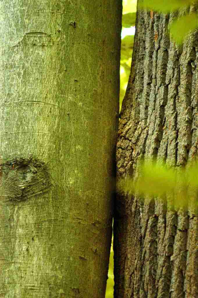
One of my favorite images, as it conjures deep thought and parallel application. In competition for sunlight this beech and yellow poplar have straight limbless trunks reaching toward the sky. The only contact they have is this butterfly kiss about 15 feet off the ground. The competition has strengthened their growth w/o hurting the other. So close together they defy the wind and reinforce each others roots inthe boulder strewn soil.
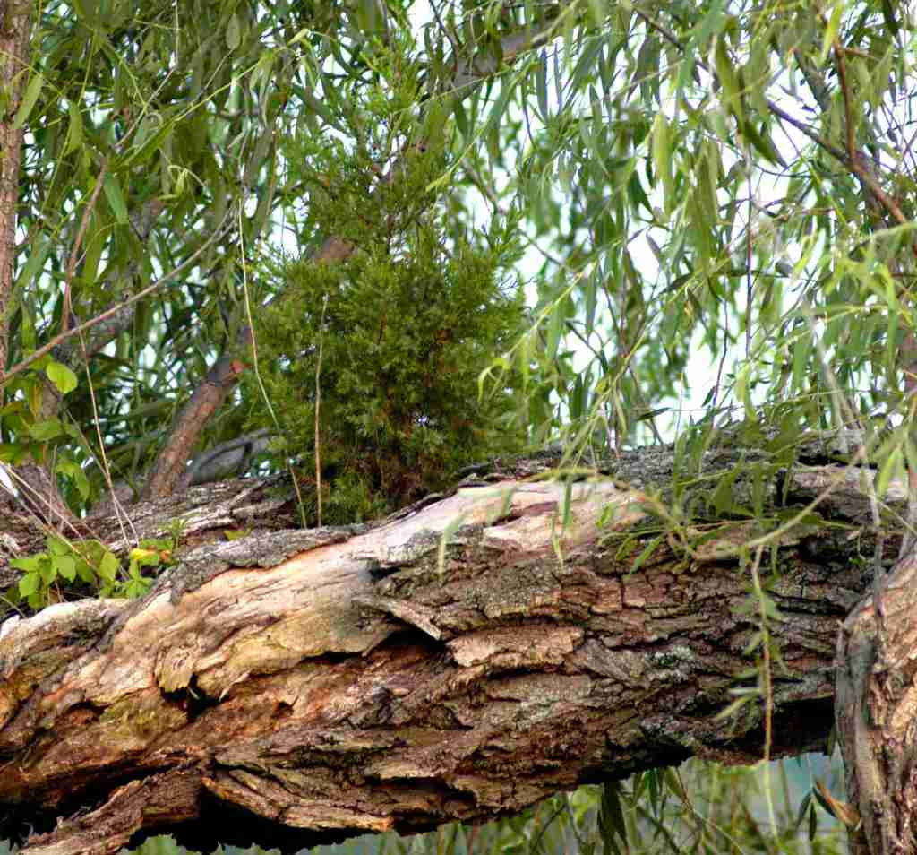
An eastern red cedar lives at the pleasure of a tattered willow 5 feet off the ground. Cedar lived for many years until the storm blew the willow over.
So much in the eastern woodlands to fire the imagination and the lessons learned from a variety tree species sharing a common ground. This should be a mandatory course in sociology!!! The Rosetta stone for civility, security, relationships, and dealing with constant change and battle scars.
Remnants of an old wire fence long forgotten, except by this tree.
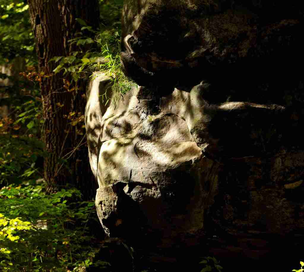
What you think you see is not necessarily what actually exists. You realize how important your imagination is and how it impacts your reality. This gorilla only appears at sunset.
Author Joe Mish has been running wild in New Jersey since childhood when he found ways to escape his mother’s watchful eyes. He continues to trek the swamps, rivers and thickets seeking to share, with the residents and visitors, all of the state’s natural beauty hidden within full view. To read more of his writing and view more of his gorgeous photographs visit Winter Bear Rising, his wordpress blog. Joe’s series “Nature on the Raritan, Hidden in Plain View” runs monthly as part of the LRWP “Voices of the Watershed” series. Writing and photos used with permission from the author.
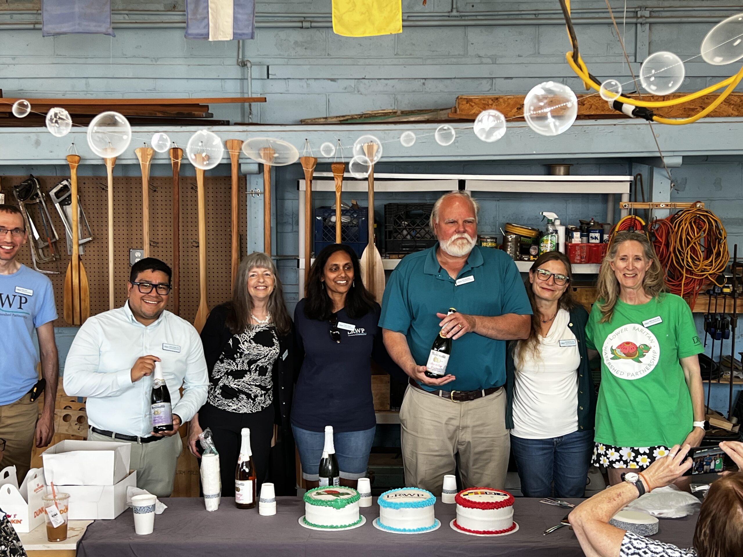
On Sept. 21, the Lower Raritan Watershed Partnership (LRWP) celebrated its tenth anniversary with a birthday party at its boathouse and headquarters in Highland Park.
LRWP Board Members from L to R: Anton Getz, Dr. Johnny Quispe, Dr. Missy Holzer, Dini Checko, Alex Zakrewsky, Amy Braunstein, Esq., Dr. Heather Fenyk
The celebration drew attention to the diverse activities of the LRWP. Vessels created as part of the LRWP’s “Rowing on the Raritan Boat Building Project” served as decor in front of tents dedicated to the LRWP’s history and recent projects.
SEWA youth partners presented a summary of their work with the LRWP in investigating the Bandalong “Bandit” Litter Trap. Throughout the summer, high schoolers and their families gave their time to monitoring the trap and recording data regarding its efficacy and the garbage it removed from the Green Brook in Dunellen.
LRWP science communication interns shared a tent with Elver the eel, a sculpture created from garbage removed from New Jersey’s watersheds. Elver was created at the LRWP’s 5K “Run Off” by Lisa Bagwell, an artist known for working with litter collected during clean-ups. Interns gave attendees information about the LRWP’s ongoing pathogen monitoring program, annual eel monitoring program, and frequent clean-up events.
Additional tents provided pamphlets about the LRWP and information about New Jersey’s biodiversity. Attendees examined a map indicating where different birds, plants, and insects resided throughout the state and discussed how many they had seen before.
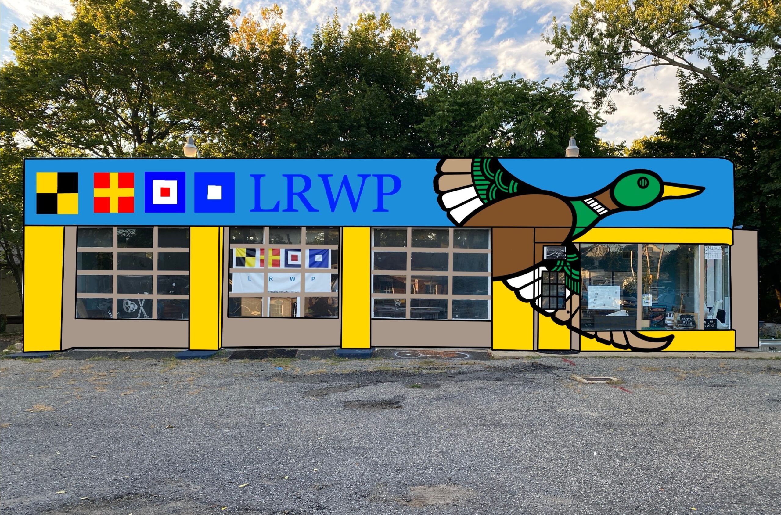
The future of the LRWP was a major theme. Attendees were encouraged to vote for their favorite of three designs for the boathouse’s upcoming repainting. A design depicting a male mallard (Anas platyrhynchos) in flight won the poll.
New facade proposal for our 101 Raritan Avenue Boat Shop – designed by RH Doaz
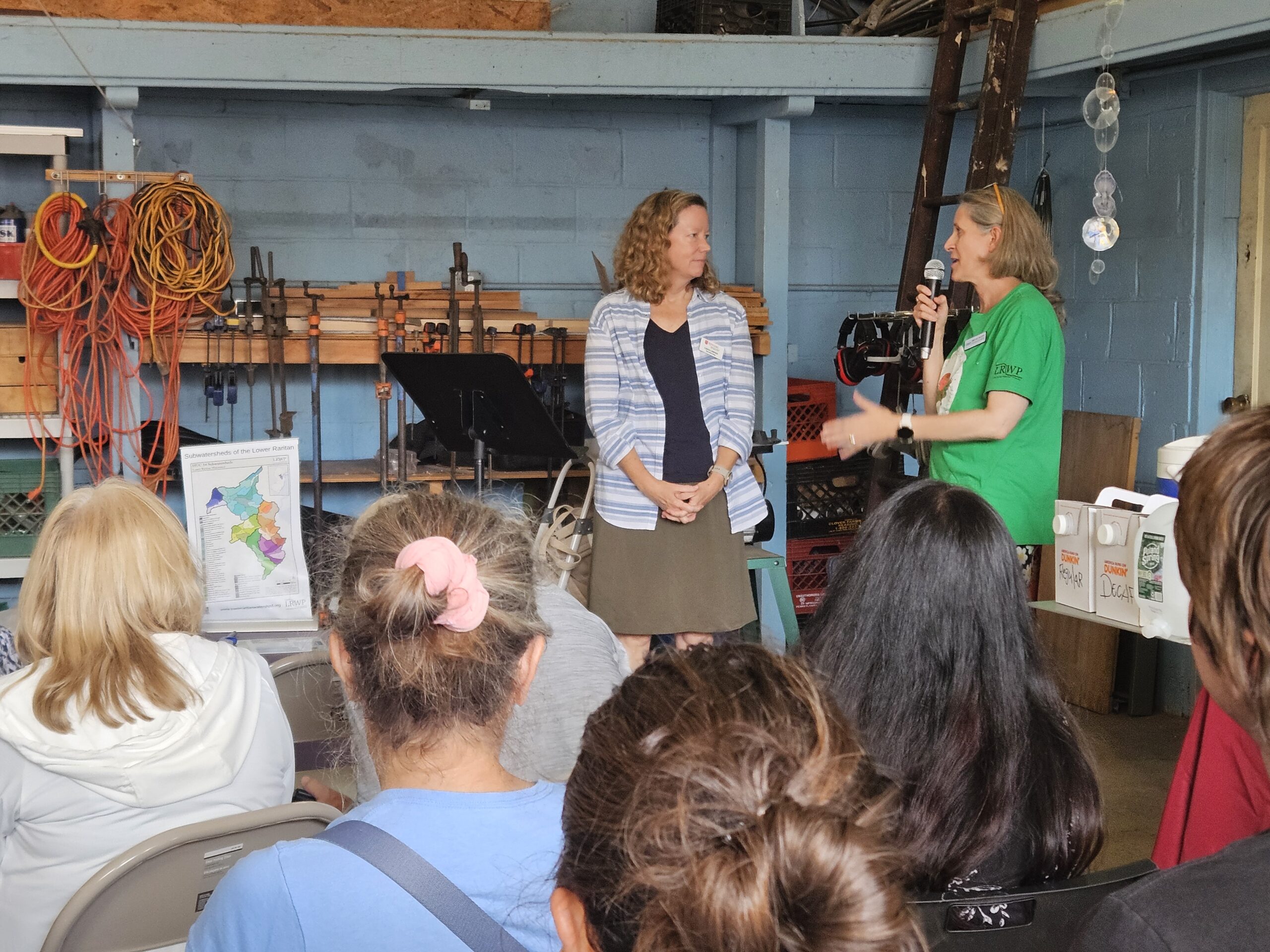
The main event was a series of speeches about the LRWP’s history, its impact, and its goals for the next 10 years.
Founder and LRWP President Dr. Heather Fenyk began by thanking the longtime supporters, and all of the friends made along the way. Heather recounted how the idea for the LRWP began with conversations regarding a plan for managing watershed area 9 from the New Jersey Department of Environmental Protection that was left hanging without funding for years, and the lack of research about “fishing for consumption” in the Raritan River.
The LRWP “emerged in partnership” with several other groups to research the safety of consuming fish from the Raritan River.
Laura Lawson (left) discussed the relationship between Rutgers and the LRWP. “My dream is that every student… has the opportunity to get on the Raritan,” Lawson said. Photo credit: Danielle Bongiovanni.
“Long story short, we realized that not only was there not much information about water health in the lower Raritan watershed… but that throughout the whole of the watershed there was a lack of data,” Heather said.
Heather, her husband Alex Zakrewsky, Amy Braunstein, and Phil George began the paperwork to officially start a nonprofit, and were quickly overwhelmed by requests and partnership offers from other organizations throughout the watershed.
A decade later, Heather emphasized a new vision based on Bill McKibben’s “Sun Day” celebration of the autumnal equinox.
“Let’s think about how our natural environment is already doing the right thing… in terms of renewable energy, renewable sources, what’s already there to celebrate.”
Other honored speakers included Executive Dean of Rutgers’ School of Environmental and Biological Sciences Laura Lawson, Assemblyman Joe Danielsen, Highland Park Councilman Phil George, and LRWP board members Johnny Quispe. They discussed their involvement with the LRWP and their hopes for the future.
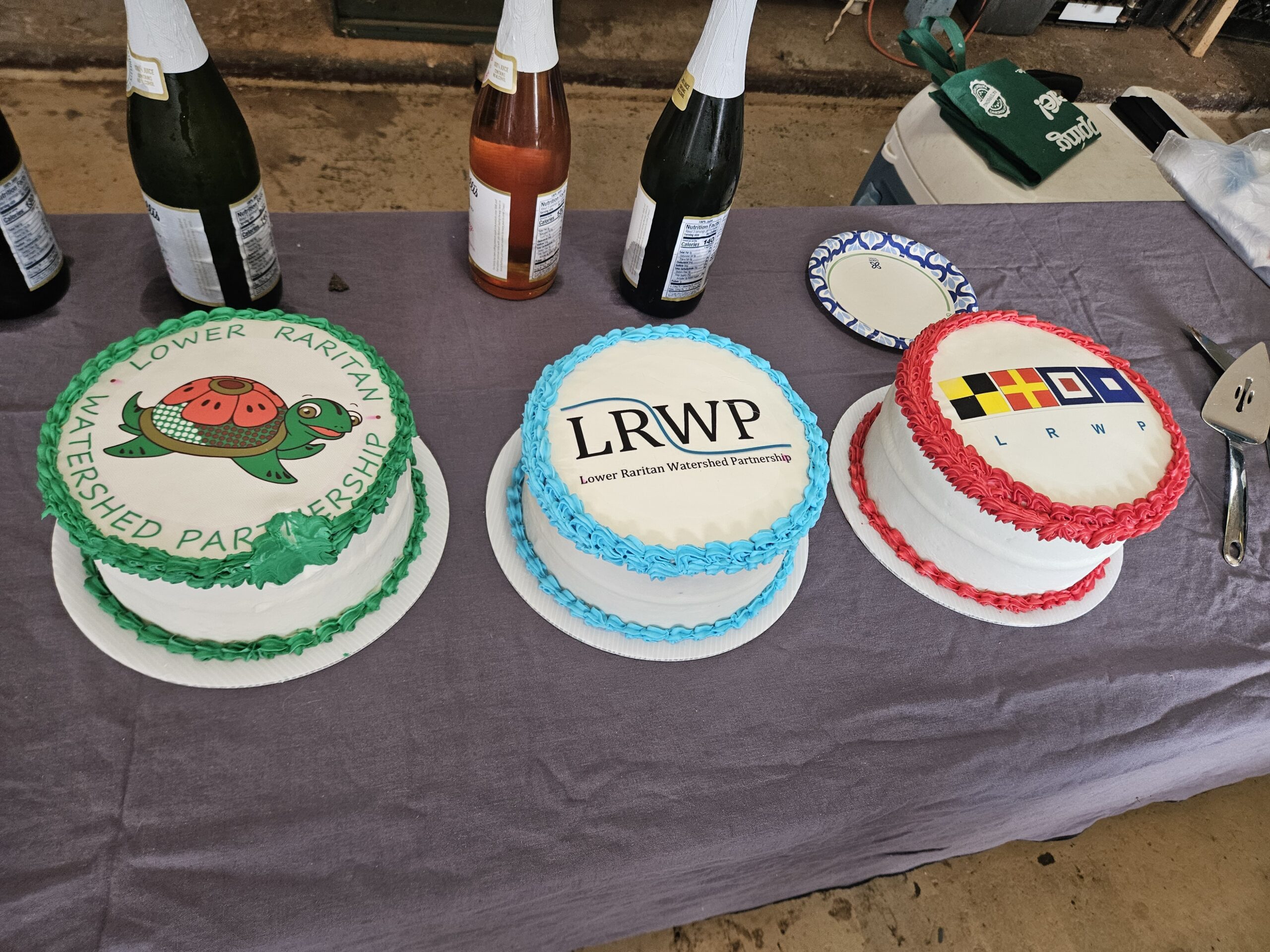
No party is complete without cake! Photo credit: Danielle Bongiovanni.
Thanks to a matching gift from Quispe and his wife Paulina, the party raised over $400 for the LRWP.
Financial will is not the only thing that will get the LRWP through another 10 years. The LRWP presented attendees with a chart of goals for the near future regarding supplies, manpower, and sponsorships. Attendees signed their names next to items they could contribute, continuing the tradition of community support.
Wishlist items that are still needed include corporate partners for clean-ups, carpenter mentors for wood workers, and a canoe/kayak trailer. Those who are interested in helping the LRWP celebrate another decade are encouraged to contact Heather at hfenyk@lowerraritanwatershed.org.
The arched doorway through the width of the old stone barn, openeded a portal into the heart of the autumn woods, now ablaze with brilliant color. The opening in the far barn wall appeared smaller and focused the uninterrupted view directly down an abandoned woods road, paved with fallen yellow leaves, to vanish within the dense autumn foliage.
The scene created a sense of timelessness, a blend of the peak fall seasons past, all travelling down an endless circular path, bridging its fore and aft companions, summer, and winter.
Autumn took the leaves summer provided, tinted them a variety of brilliant colors, and wove a bright carpet to cover the bare land before the white quilt of winter snow is delivered.
The palette of fall color covers the visible spectrum with red, orange, yellow, blue, green, indigo and violet stirred, shaken, and swirled to create ambers, scarlets, magenta and purple tints. Red and yellow are primary colors that combine to produce various shades and intensities of orange. Yellow dominates in nature and serves as a background to emphasize the mosaic of red and yellow variants.
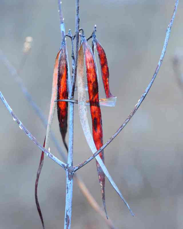
Slight blue tint on the dogbane pods and nowhere else, is a display of nature’s subtle use of tints and shades.
Red often needs a bright companion color in a mixed woodland to stand out, as the intensity of the red lacks in brightness. Native red maples will produce leaves with irregular splotches of red on yellow, the red often the color of fresh blood.
Early in the season splotches of red will appear among green foliage as virginia creeper, poison ivy and staghorn sumac, these are the preliminary sparks lit, to start the fall conflagration of flaming color.
Red variants include the bright salmon color of black gum and the purple wash common to sweet gum leaves. Sweet gum displays quite a variety of scarlet tints ranging from pale reds to shades of purple on a yellow canvas.
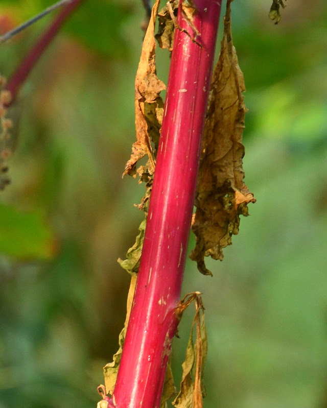
The brilliance of deep magenta stems of poke weed, vie only with the intensity of fluorescent orange oak leaves. The magenta is so brilliant and stems so straight, it appears alien to the natural landscape. The stems are unmistakable exclamation points impossible to miss.
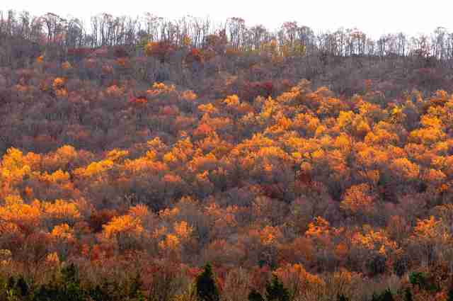
Some individual red and black oaks produce an orange leaf so brilliant as the be described as fluorescent. The leaves appear to glow with an incandescence that acts as a visual magnet. It has been established that colors affect mood and behavior and from that theory, chromotherapy has evolved. Chromotherapy is a holistic healing technique and nature provides that treatment with fall colors. Orange, associated with boosting energy and creativity comes appropriately after the green therapy session of summer where peace, balance and calm dominated. Heightened energy and creativity provided by the orange variants are choreographed to arrive in time to meet the challenges of the coming winter. In that way the autumn blaze translates the subtle impact of decreasing daylength into a visual announcement; a planned redundancy by nature to ensure human survival.
The fall color can be appreciated in layers as the focal length of the lens is adjusted. A single leaf becomes an individual portrait looking like no other under high magnification. Reduce the focal length and see an entire mountainside draped in waves of yellow color.
An aerial view, seen through a time lapsed camera, animates the arrival of fall as is slowly moves south, the bright colors consuming the green foliage.
A classic fall scene of a leaf littered winding dirt road disappearing around a distant bend, into the embrace of a mass of flaming foliage, invites you to step inside the image. Walking down that old time forgotten road, curiosity beckons you to travel further, beyond the curve, into a world where time stands still and memories of autumns past eagerly await your arrival.
Author Joe Mish has been running wild in New Jersey since childhood when he found ways to escape his mother’s watchful eyes. He continues to trek the swamps, rivers and thickets seeking to share, with the residents and visitors, all of the state’s natural beauty hidden within full view. To read more of his writing and view more of his gorgeous photographs visit Winter Bear Rising, his wordpress blog. Joe’s series “Nature on the Raritan, Hidden in Plain View” runs monthly as part of the LRWP “Voices of the Watershed” series. Writing and photos used with permission from the author.
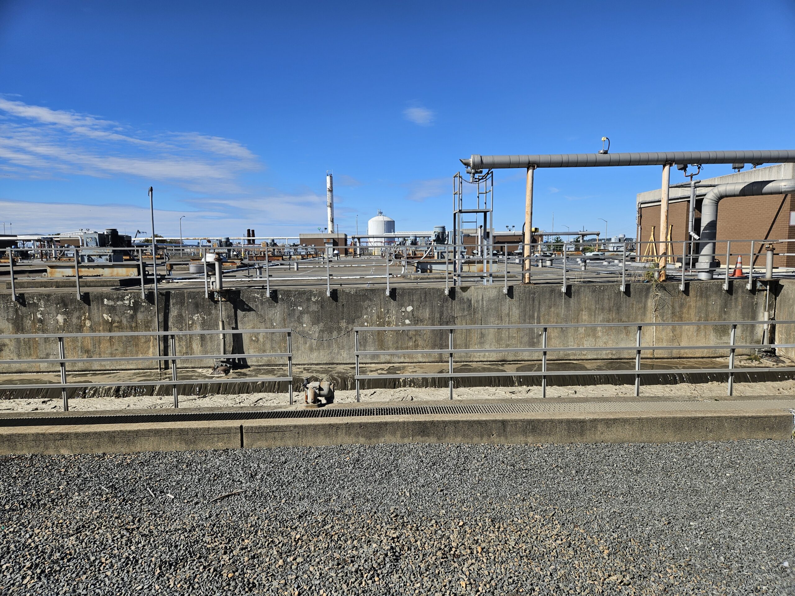
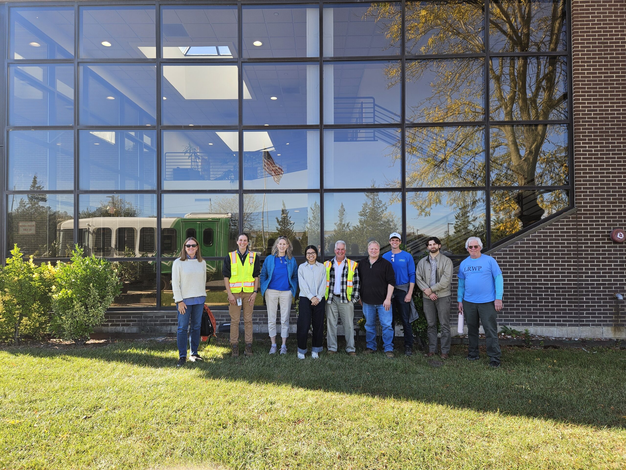
On Friday October 17 the LRWP toured the Middlesex County Utilities Authority (MCUA) wastewater processing and treatment plant. While there we learned about the processes of removing and eliminating contaminants from wastewater, and gained understanding of how wastes are converted into an effluent that can be returned to the water cycle through primary outfalls in Raritan Bay and the Raritan River.
With many thanks to Lisa Oberreiter, General Superintendent at Middlesex County Utilities Authority and her staff for a fascinating explanation of how things work “behind the scenes”. You can hear Lisa’s voice in this youtube video as she explains the important process of aeration in sewage treatment.
MCUA’s Lisa Oberreiter is second from left. Pathogens monitoring team members Johnny Meyer, Frank Dahl and Heather Fenyk also joined the tour.
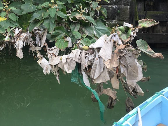
During the LRWP’s pathogens monitoring work we often observe “flushable” sanitary wipes floating in the River and caught in vegetation along the riverbank. So-called “flushable” wipes are non-flushable! They are typically made from synthetic materials and do not easily break down in sewer systems.
There is no such thing as a “flushable” wipe!
These materials escape the process of wastewater treatment, most typically at the point at which sanitary sewage infrastructure and stormwater infrastructure meet, in an outdated system called a “combined sewer”. As these materials escape the processing system, they contribute to the presence of disease-causing pathogens in our waterways and cause beach closures. As they are caught up in the processing activity, they lead to huge costs to wastewater systems like the treatment plant in Sayreville, causing clogs and damage to wastewater pipes, pumps, and treatment equipment.
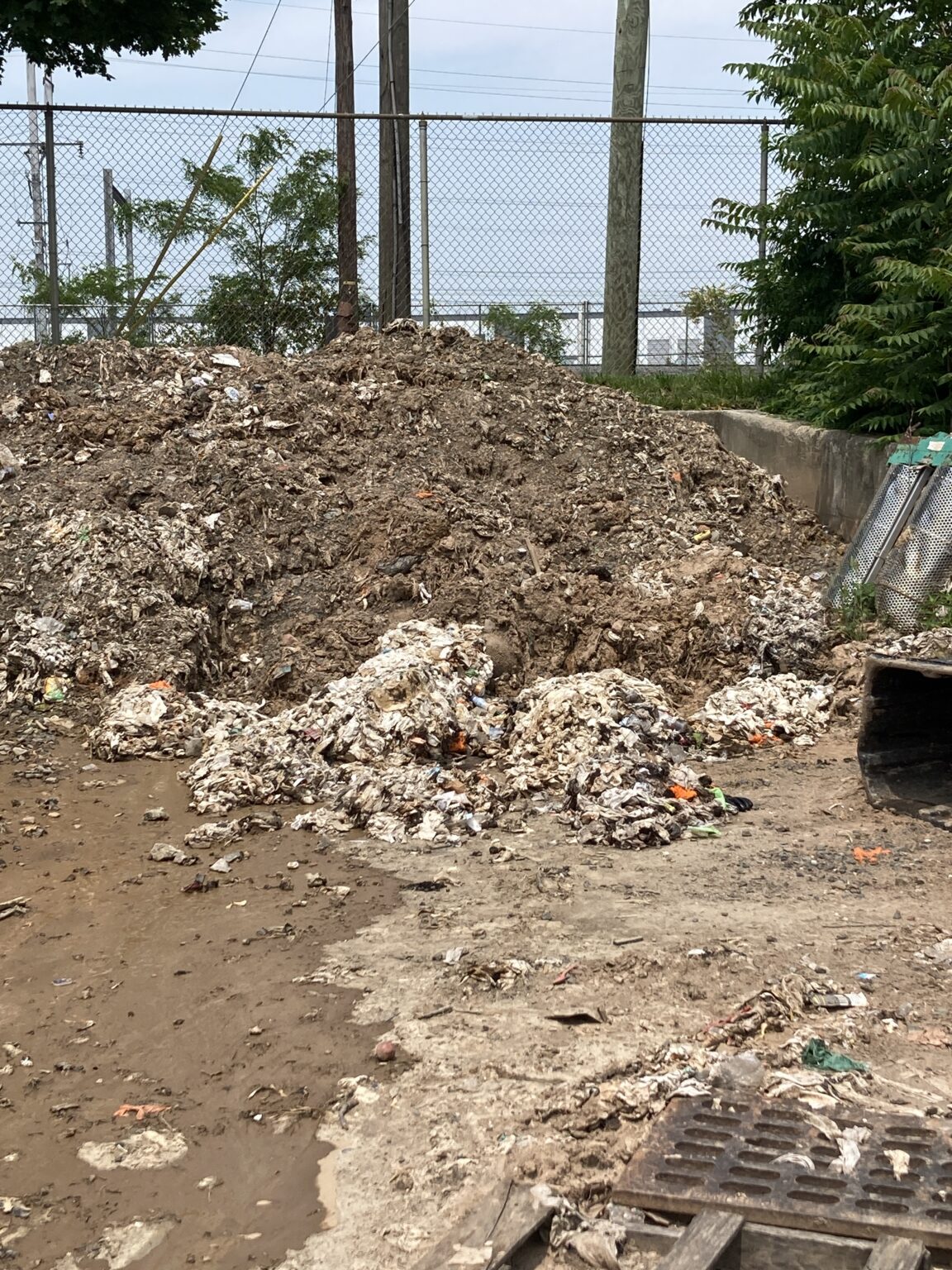
Wastewater collection systems must periodically cleared of the clogs of sanitary wipes and other materials that become trapped in underground intercepting structures to limit the flows of this waste through the CSO outfalls. While conducting pathogens monitoring on June 5, 2025 at our water monitoring station near Perth Amboy’s Wilentz Elementary School, the LRWP team observed a pile of the waste cleared from an intercepting structure near the City of Perth Amboy-managed CSO. Approximately four tons of wipes and feces were removed from the interception point and deposited on land to await transport to a landfill.
This practice of removing wipes from interception points and dumping them on land to minimize flush into waterways and damage to sanitary sewage infrastructure is not unique to managers of such properties, or even to managers of CSOs in New Jersey. This is a permitted practice under the Clean Water Act that is managed by the state Department of Environmental Protection. Each CSO has a separate permit, and each municipality must adopt a Long Term Control Plan (LTCP) for CSO management.
Taking Action
Could present day practices be improved for our local CSOs? Absolutely. All utilities should be working to identify and elevate best practices with respect to CSO management.
In addition, in March 2025 Republican Conference Chairwoman Lisa McClain of Michigan introduced H.R. 2269, the Wastewater Infrastructure Pollution Prevention and Environmental Safety (WIPPES) Act. On June 23, 2025 it passed the Senate and moved to the House where its companion S. 1092 (Merkley) was favorably reported out of the Committee on Commerce, Science, and Transportation in late May. The WIPPES Act would establish a national “DO NOT FLUSH” labeling standard for non-flushable wet wipes. If WIPPES is signed into law, wet wipe manufacturers would be required to place symbols and standard language labeling on products that recommends consumers not flush the wipes after use. It would further restrict any verbiage on packaging that would imply that the product is actually flushable. Regulation of the policy would have the teeth of the Federal Trade Commission, with violations punishable as an unfair or deceptive practice.
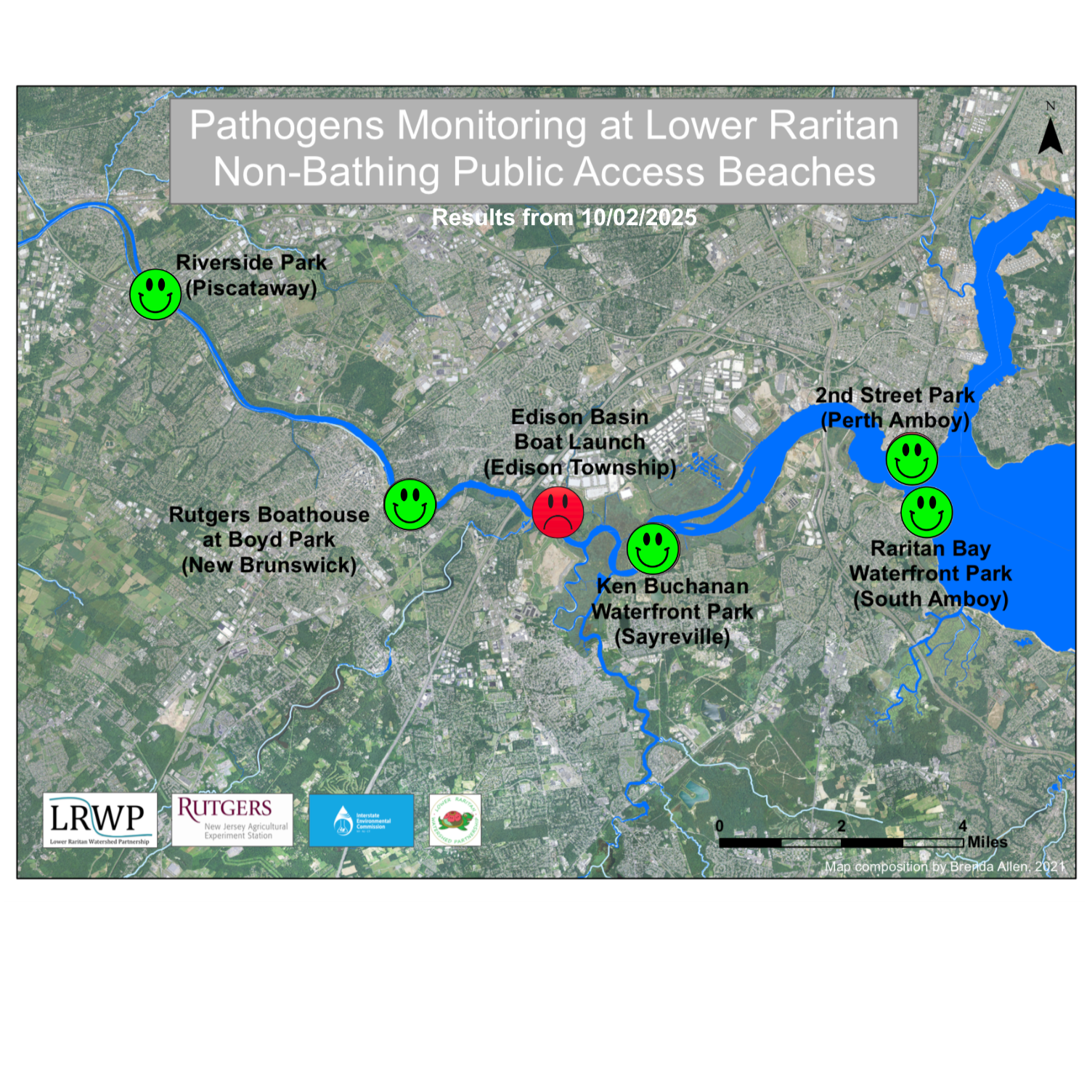
The last pathogen monitoring session of the season took place on Thursday, October 2nd. Each week during the summer, from May to October, the Lower Raritan Watershed Partnership and Rutgers Cooperative Extension of Middlesex County run a volunteer-based monitoring program along the Raritan River. We collect water quality samples at six non-bathing public access beach sites, provide our samples to the Interstate Environmental Commission for analysis in their laboratory, and report the results to the public. Our mission is to share this data with the community and partners to ensure the safe use of the Raritan river for all.
To close out the 2026 season, we were joined in the field by Dr. Anne Gharaibeh, Visiting Professor of Landscape Architecture from Jordan University of Science and Technology, and Patty Oehmke, Rutgers Family and Community Health Sciences Professor of Practice. We were also joined by our new Rutgers research intern Margaret Reinerth. Welcome, Margaret!
Our lab results for water quality samples taken on Thursday, October 2nd, 2025 show Enterococcus bacteria levels exceeding the EPA federal water quality standard of 104 cfu/100mL at one of our monitoring sites this week. Problem sites would be indicated by red frowns on the map and chart; this week, the only red frown was at the Edison Boat Basin(Edison Township). Green smiles on the chart and map indicate the sites with bacteria levels safe for recreation, and include the following: Riverside Park (Piscataway), Rutgers Boathouse (New Brunswick), Ken Buchanan Waterfront Park (Sayreville), Raritan Bay Waterfront Park (South Amboy), and 2nd Street Park (Perth Amboy).
Pathogens/Enterococci levels are used as indicators of the possible presence of disease-causing bacteria in recreational waters. Such pathogens may pose health risks to people coming in primary contact with the water (touching) through recreational activities like fishing, kayaking or swimming in a water body. Possible sources of bacteria include Combined Sewer Overflows (CSOs), improperly functioning wastewater treatment plants, stormwater runoff, leaking septic systems, animal carcasses, pet waste, wildlife waste, and runoff from manure storage areas.
Our goal in reporting these results is to give residents a better understanding of the potential health risks related to primary contact during water-based recreation. If you are planning on recreating on the Raritan this weekend, make sure to stay safe and wash up after any activities!
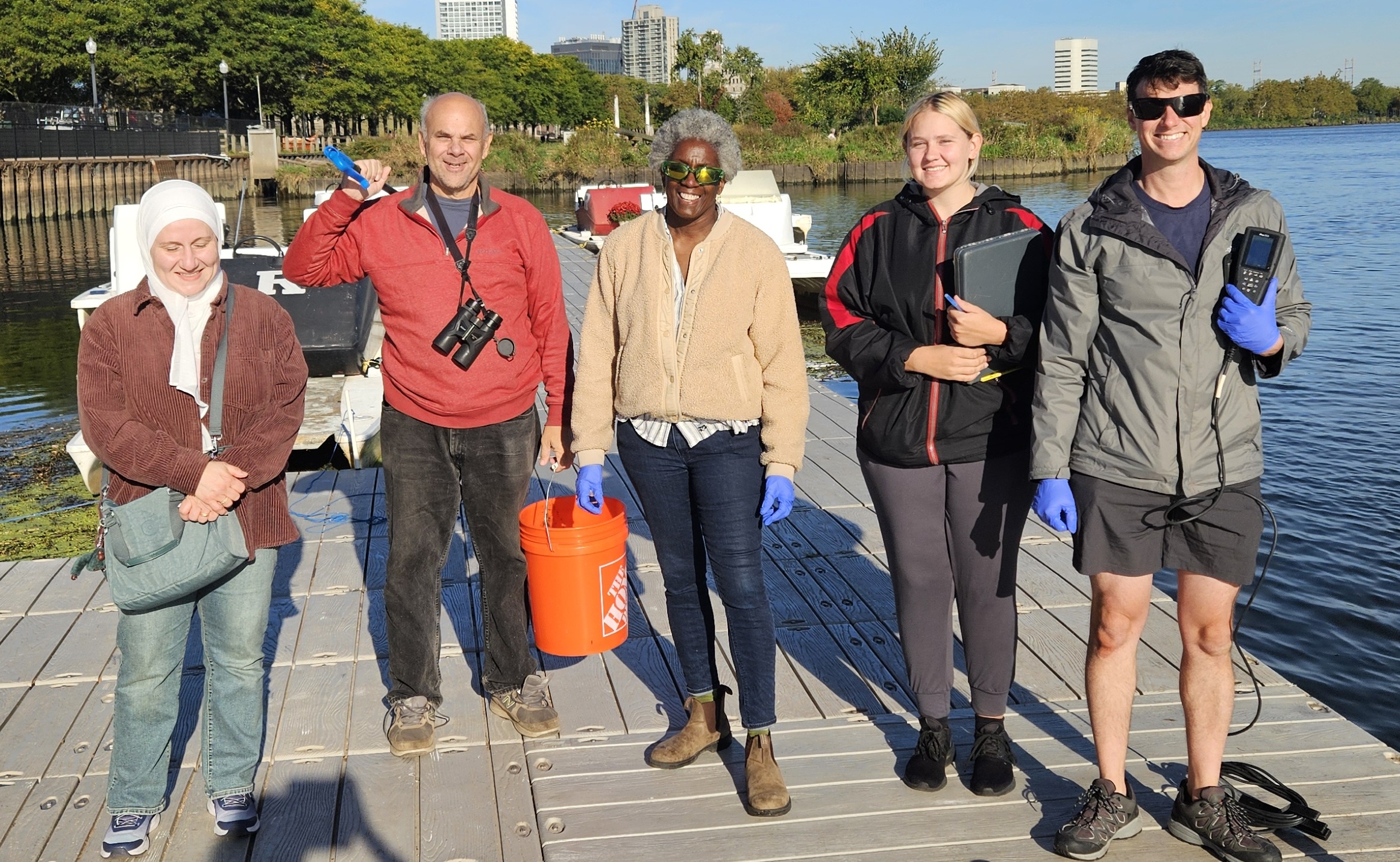
From left to right, Dr. Anne Gharaibeh (Visiting Professor of Landscape Architecture from Jordan University of Science and Technology), Art Allgauer, Patty Oehmke (Rutgers Family and Community Health Sciences Professor of Practice), Margaret Reinerth, and John Meyer. Photo credit: Heather Fenyk.
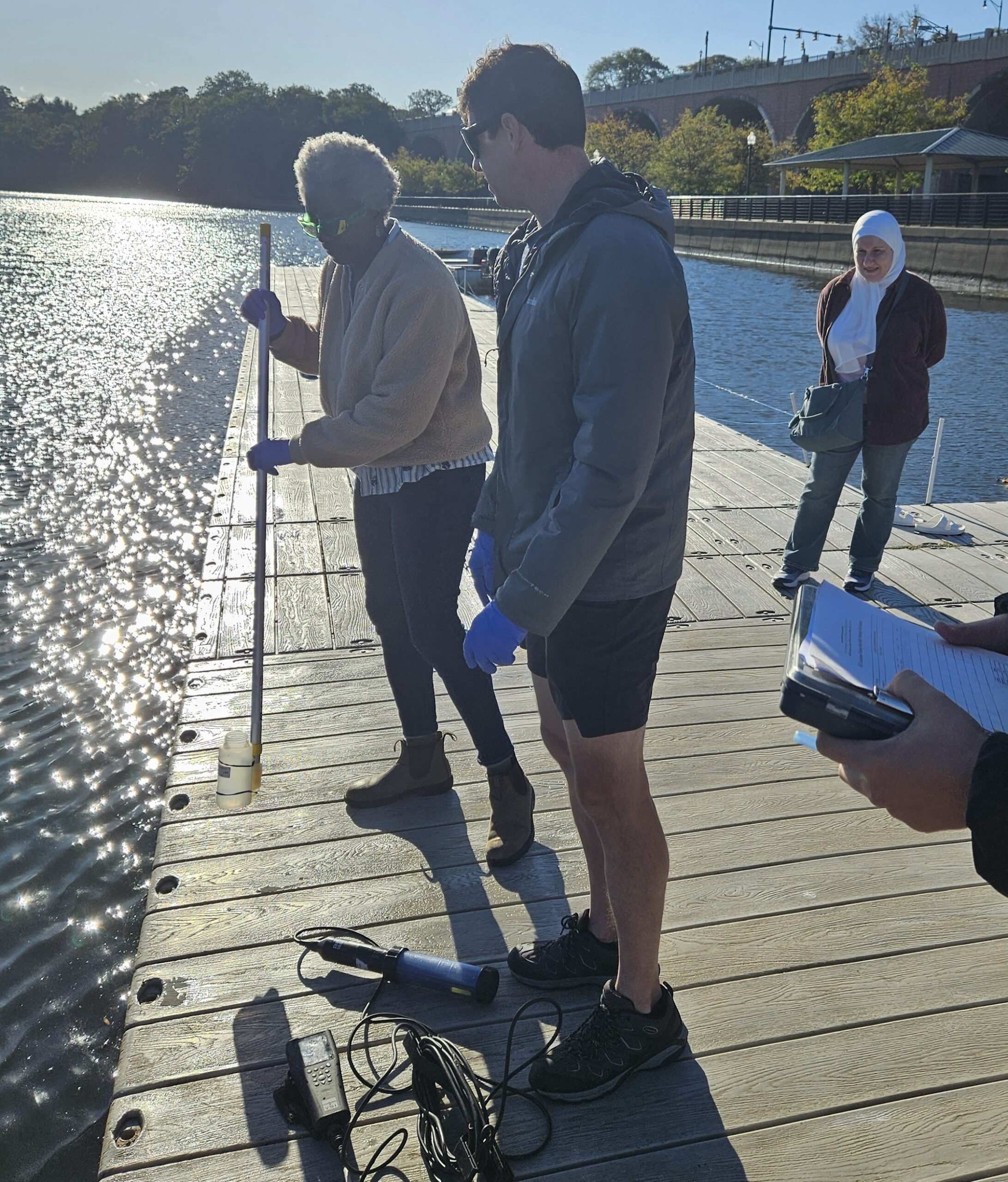
Patty Oehmke gathers a sample from the Raritan River. Photo credit: Heather Fenyk.
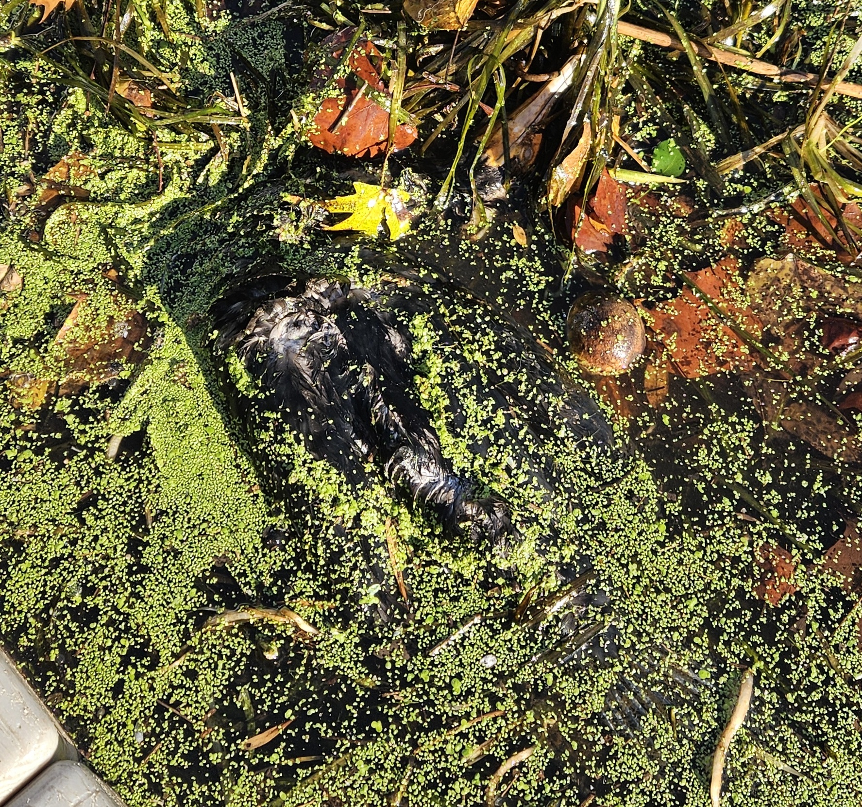
A deceased double-crested cormorant (Nannopterum auritum) floats in the water near the Rutgers Boat House in New Brunswick. Photo credit: Heather Fenyk.
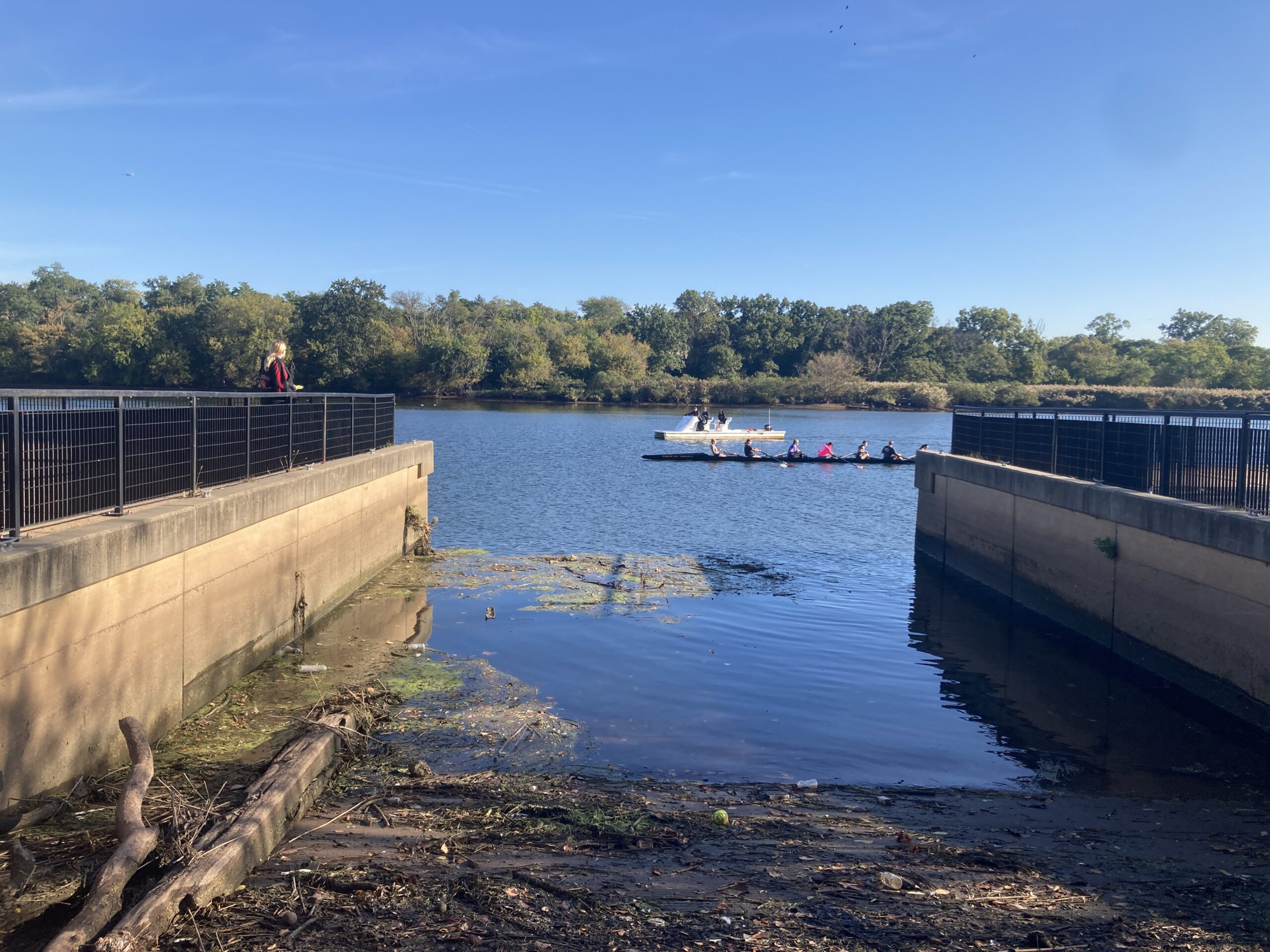
A Rutgers crew team pulls past the Boyd Park boat launch in New Brunswick. Photo credit: J.M. Meyer.
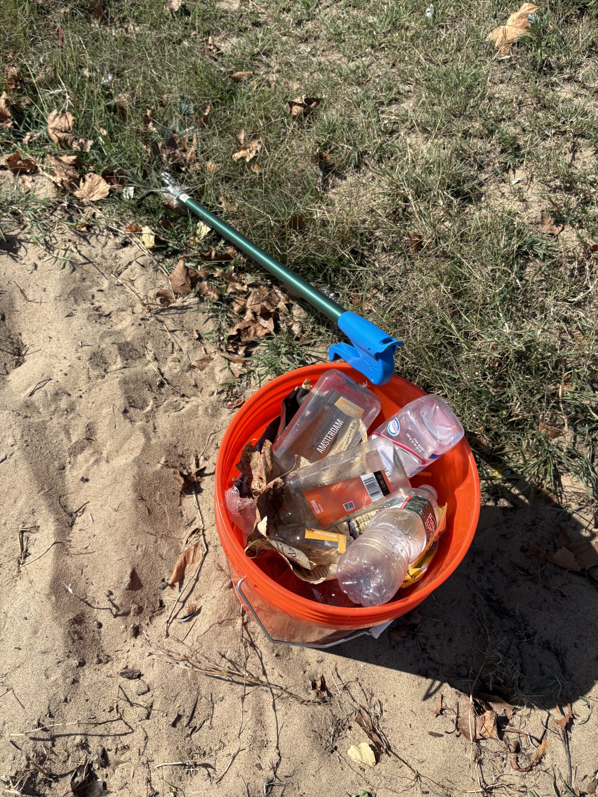
Art Allgauer has been our most steadfast volunteer this season. He specialized in completing our visual habitat assessment at each of the six sites, and he personally removed over 50 gallons of litter from our shoreline (possibly far more). Thank you, Art! Photo credit: J.M. Meyer.
Trash collected from Perth Amboy’s 2nd Street park. Photo credit: Art Allgauer.
John and Margaret use the YSI sonde to gather data in Piscataway. Photo credit: Art Allgauer.
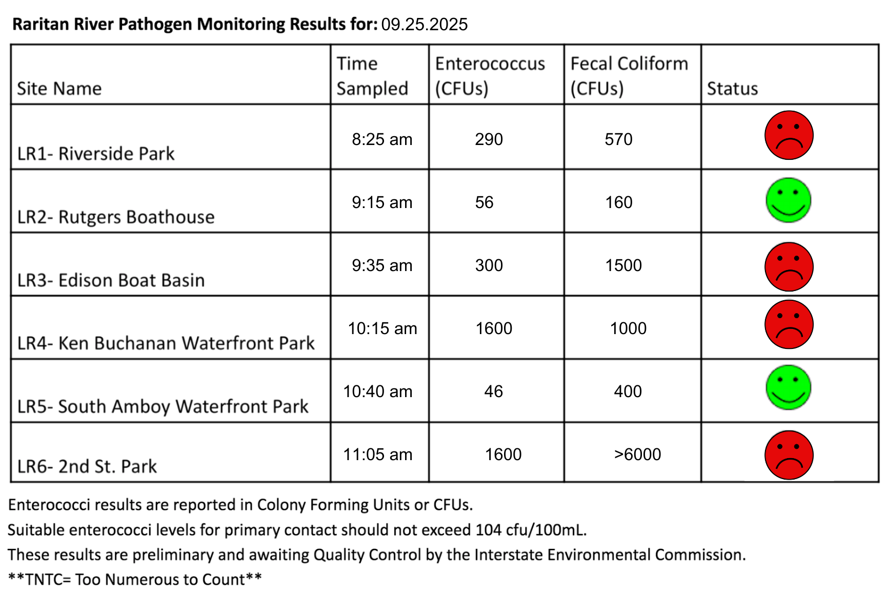
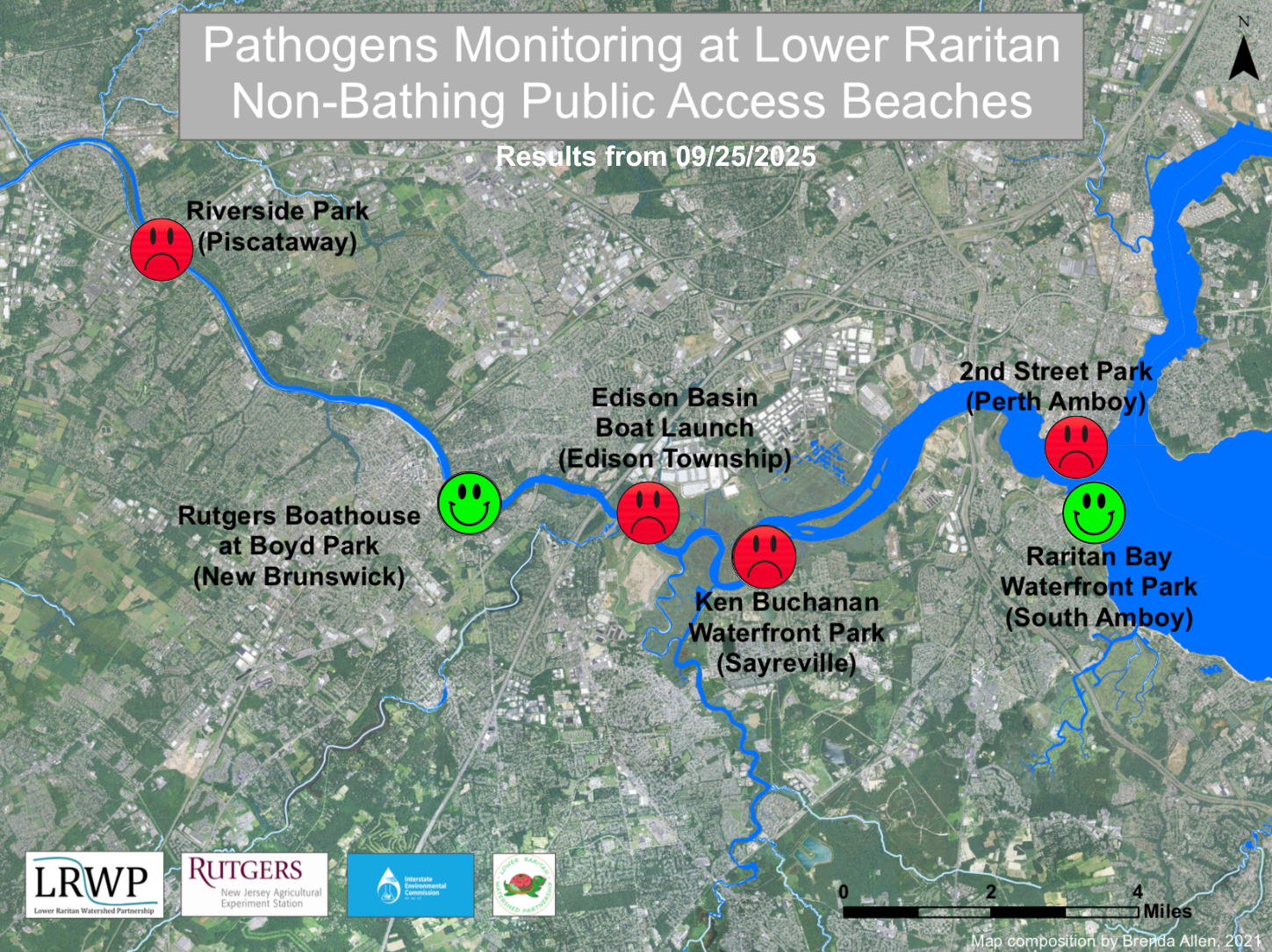
The last pathogen monitoring session of September took place on Thursday, September 25th. Each week during the summer, from May to October, the Lower Raritan Watershed Partnership and Rutgers Cooperative Extension of Middlesex County run a volunteer-based monitoring program along the Raritan River. We collect water quality samples at six non-bathing public access beach sites, provide our samples to the Interstate Environmental Commission for analysis in their laboratory, and report the results to the public. Our mission is to share this data with the community and partners to ensure the safe use of the Raritan river for all.
Our lab results for water quality samples taken on Thursday, September 25th, 2025 show Enterococcus bacteria levels exceeding the EPA federal water quality standard of 104 cfu/100mL at four of our monitoring sites this week. Problem sites would be indicated by red frowns on the map and chart which includes: Riverside Park (Piscataway), Edison Boat Basin(Edison Township), and Ken Buchanan Waterfront Park (Sayreville), and 2nd Street Park (Perth Amboy). Green smiles on the chart and map indicate the sites with bacteria levels safe for recreation, and include the following: Rutgers Boathouse (New Brunswick) and Raritan Bay Waterfront Park (South Amboy).
Pathogens/Enterococci levels are used as indicators of the possible presence of disease-causing bacteria in recreational waters. Such pathogens may pose health risks to people coming in primary contact with the water (touching) through recreational activities like fishing, kayaking or swimming in a water body. Possible sources of bacteria include Combined Sewer Overflows (CSOs), improperly functioning wastewater treatment plants, stormwater runoff, leaking septic systems, animal carcasses, pet waste, wildlife waste, and runoff from manure storage areas.
Our goal in reporting these results is to give residents a better understanding of the potential health risks related to primary contact during water-based recreation. If you are planning on recreating on the Raritan this weekend, make sure to stay safe and wash up after any activities!
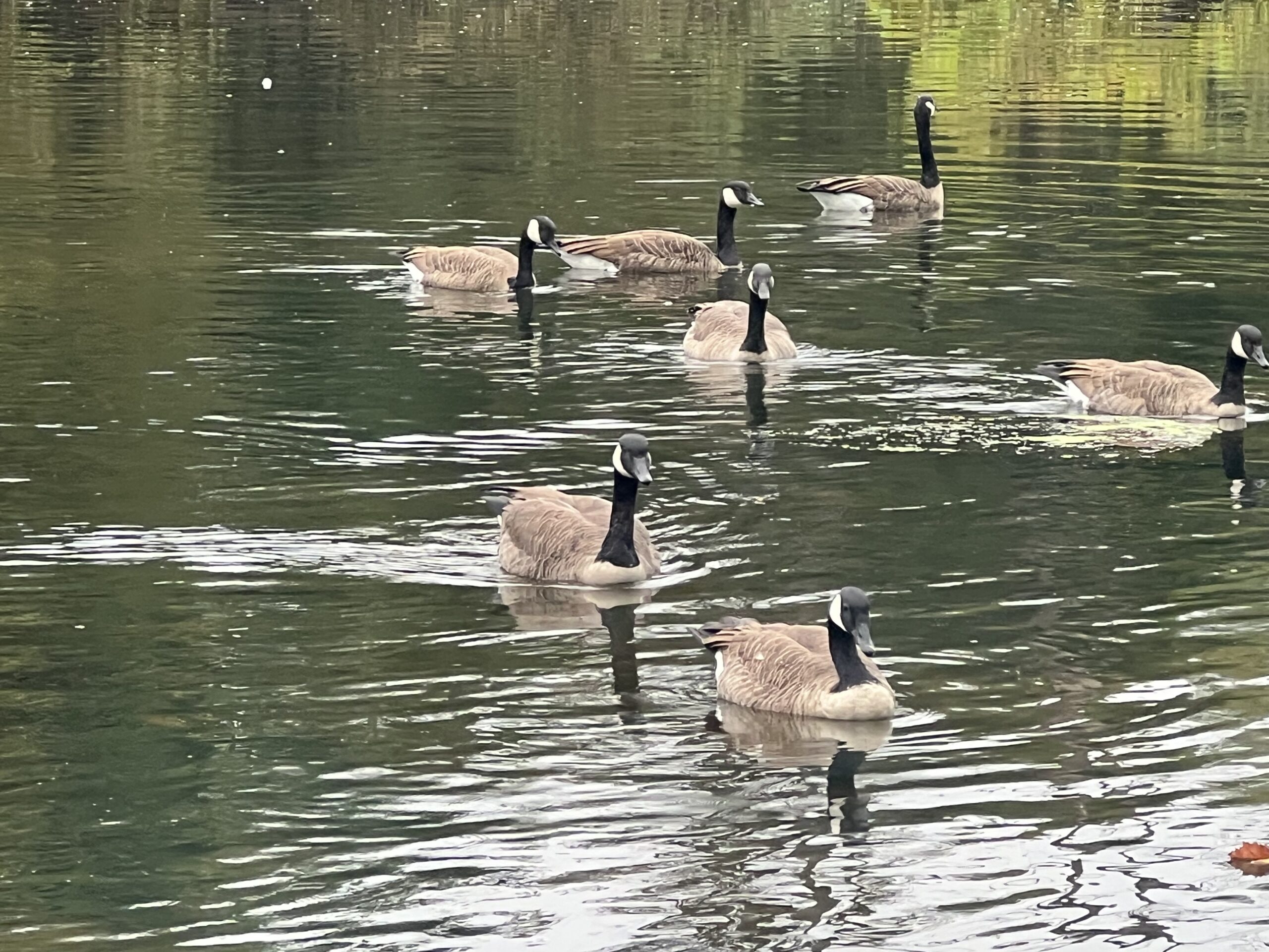
A flock of Canada Geese (Branta canadensis) inspect the river in Piscataway. Photo credit: Sofi Grossman.
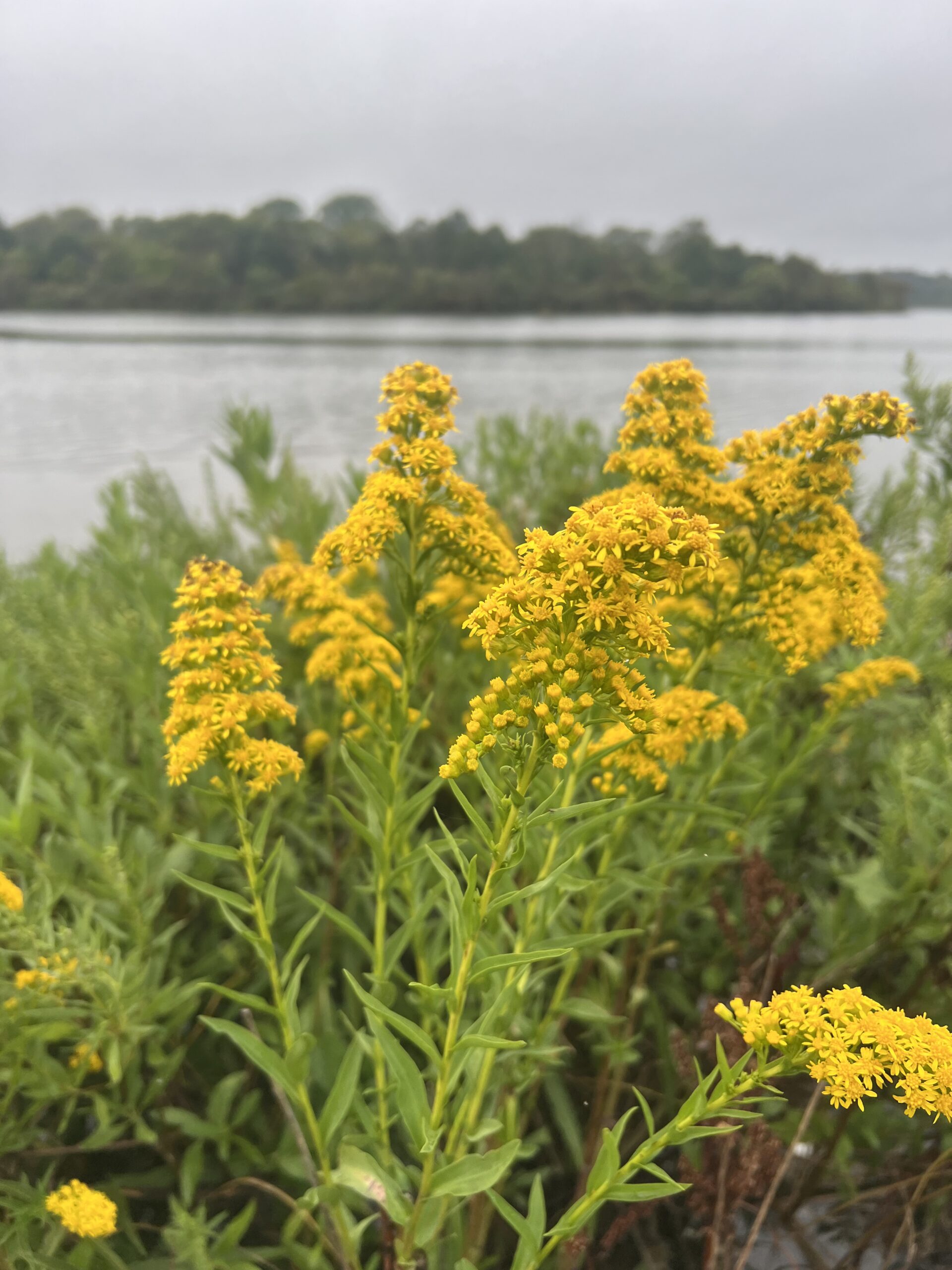
Goldenrod (solidago) blooms along the river at the Edison Boat Basin. Photo credit: Sofi Grossman.
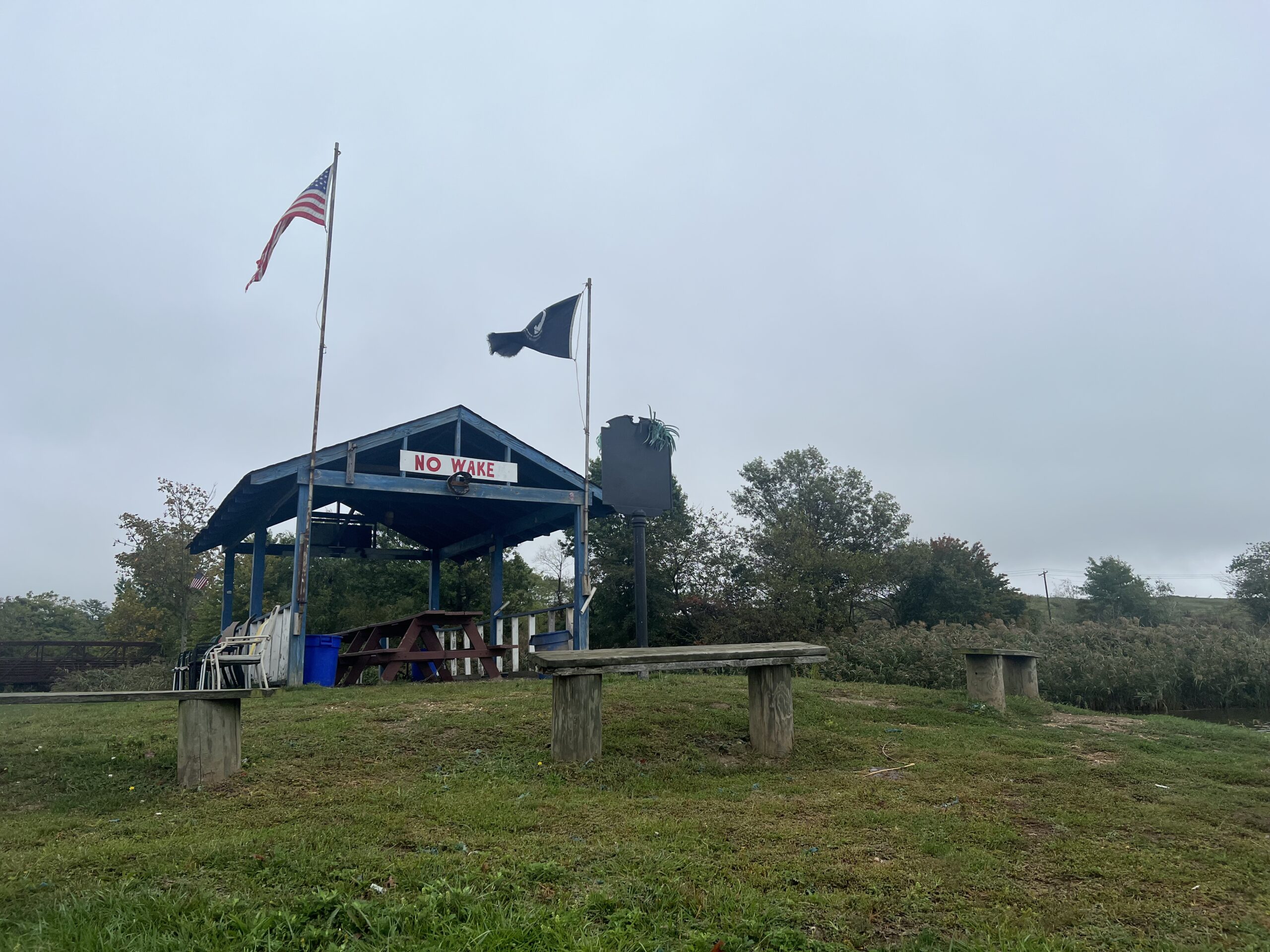
Signage at the Edison Boat Basin reminds boaters to slow down. Photo credit: Sofi Grossman.
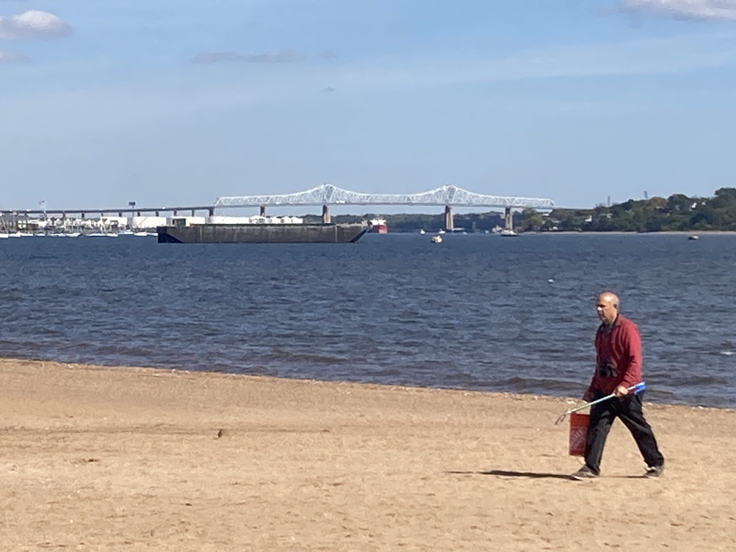
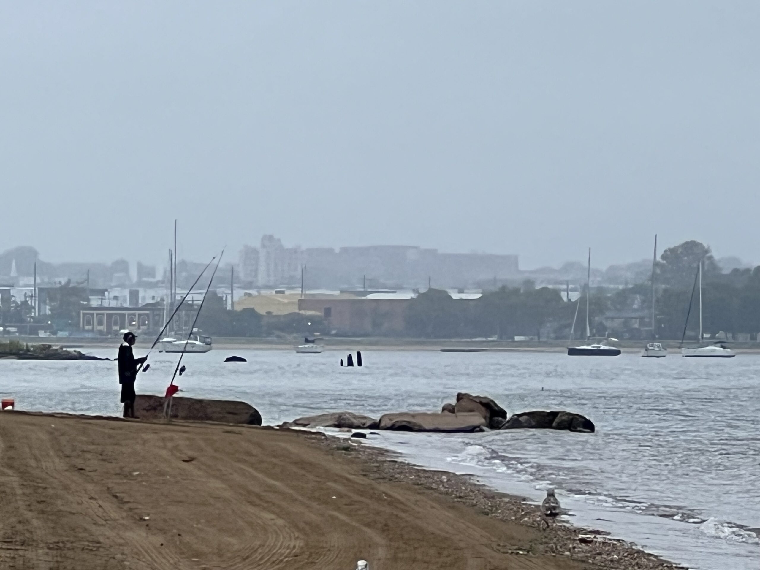
A fisherman casts a line along the shore in South Amboy. In the distance, Perth Amboy is visible in the fog. Photo credit: Sofi Grossman.
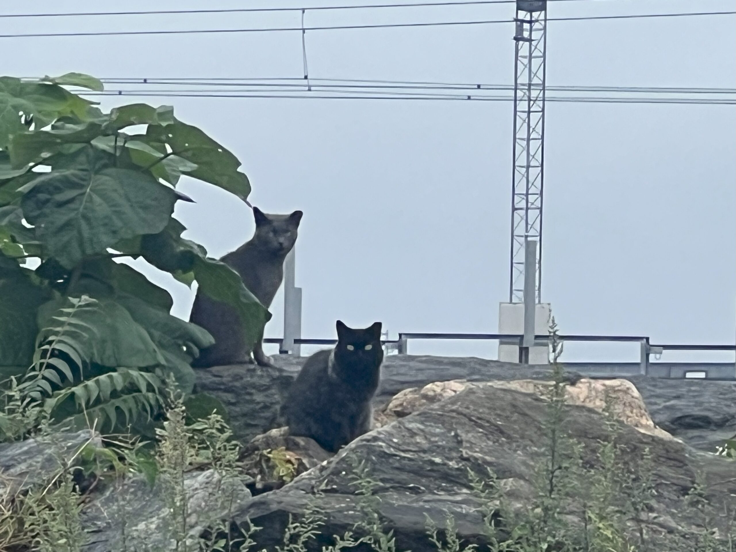
Cats warily eye our water monitoring team in Perth Amboy. Photo credit: Sofi Grossman.
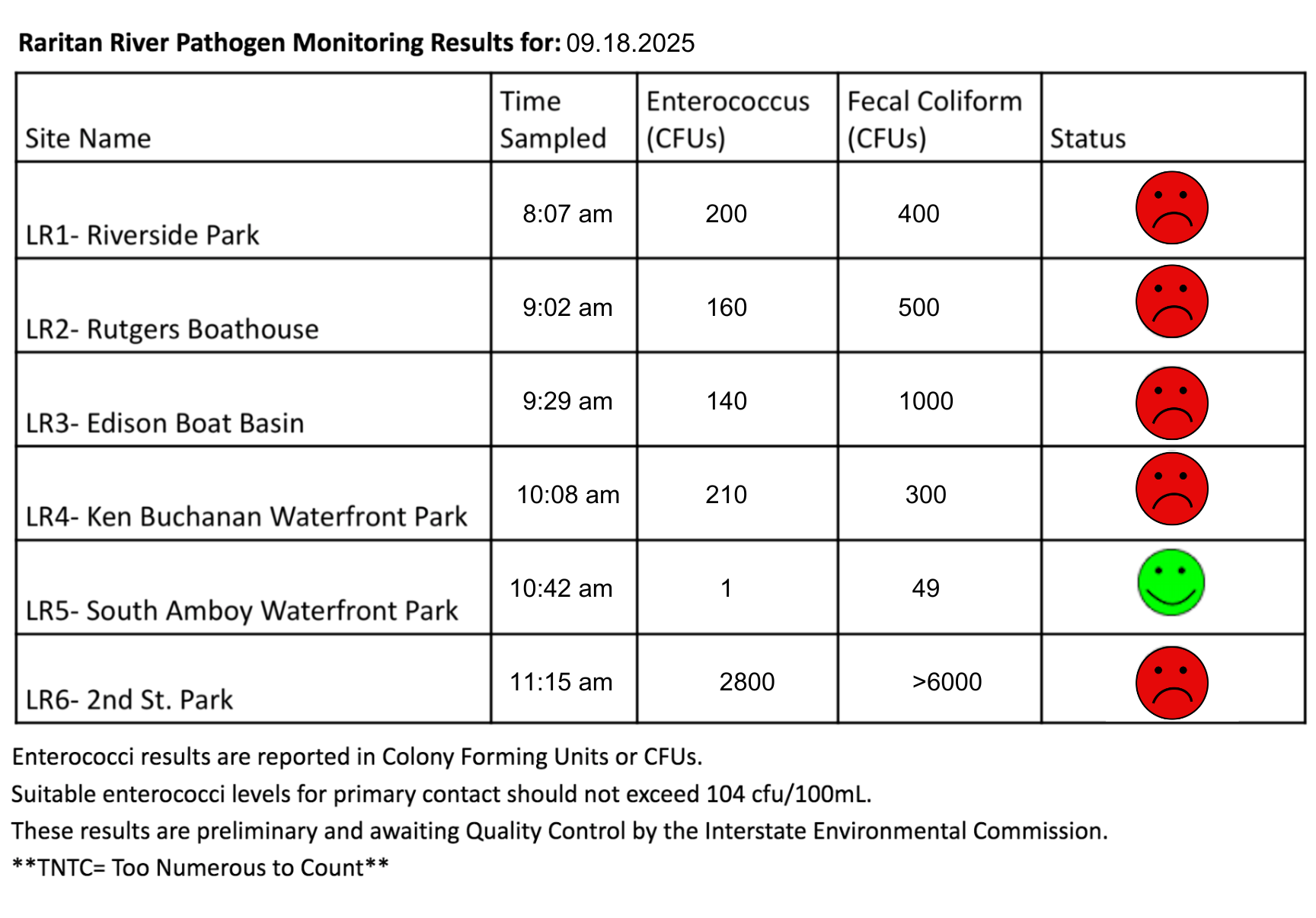
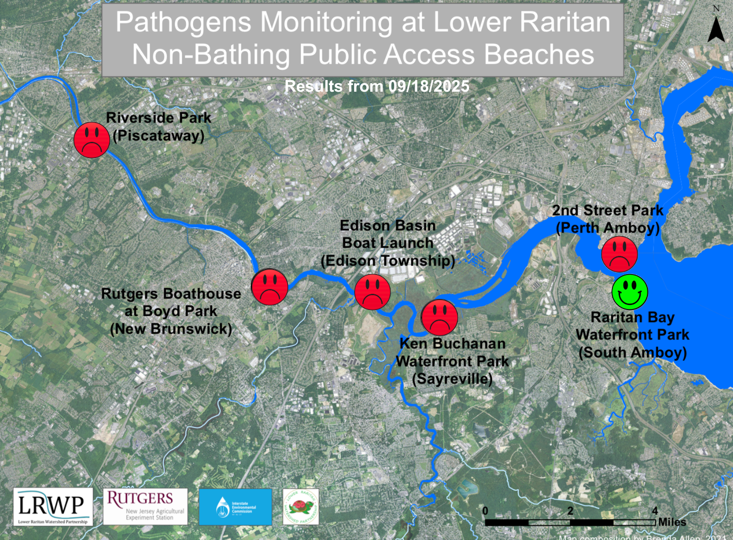
The third pathogen monitoring session of the month took place on Thursday, September 18th. Each week during the summer, from May to October, the Lower Raritan Watershed Partnership and Rutgers Cooperative Extension of Middlesex County run a volunteer-based monitoring program along the Raritan River. We collect water quality samples at six non-bathing public access beach sites, provide our samples to the Interstate Environmental Commission for analysis in their laboratory, and report the results to the public. Our mission is to share this data with the community and partners to ensure the safe use of the Raritan river for all.
Our lab results for water quality samples taken on Thursday, September 18th, 2025 show Enterococcus bacteria levels exceeding the EPA federal water quality standard of 104 cfu/100mL at five of our monitoring sites this week. Problem sites would be indicated by red frowns on the map and chart which includes: Riverside Park (Piscataway), Rutgers Boathouse (New Brunswick), Edison Boat Basin(Edison Township), and Ken Buchanan Waterfront Park (Sayreville), and 2nd Street Park (Perth Amboy). Out of an abundance of caution, a red fown has been assigned to it. Green smiles on the chart and map indicate the sites with bacteria levels safe for recreation, and include the following: Raritan Bay Waterfront Park (South Amboy).
Pathogens/Enterococci levels are used as indicators of the possible presence of disease-causing bacteria in recreational waters. Such pathogens may pose health risks to people coming in primary contact with the water (touching) through recreational activities like fishing, kayaking or swimming in a water body. Possible sources of bacteria include Combined Sewer Overflows (CSOs), improperly functioning wastewater treatment plants, stormwater runoff, leaking septic systems, animal carcasses, pet waste, wildlife waste, and runoff from manure storage areas.
Our goal in reporting these results is to give residents a better understanding of the potential health risks related to primary contact during water-based recreation. If you are planning on recreating on the Raritan this weekend, make sure to stay safe and wash up after any activities!
After the rains on Wednesday, we saw quite a bit of sediment and algae in the water on Thursday. Here’s what the buildup looked like at Riverside Park in Piscataway. Photo credit: Art Allgauer.
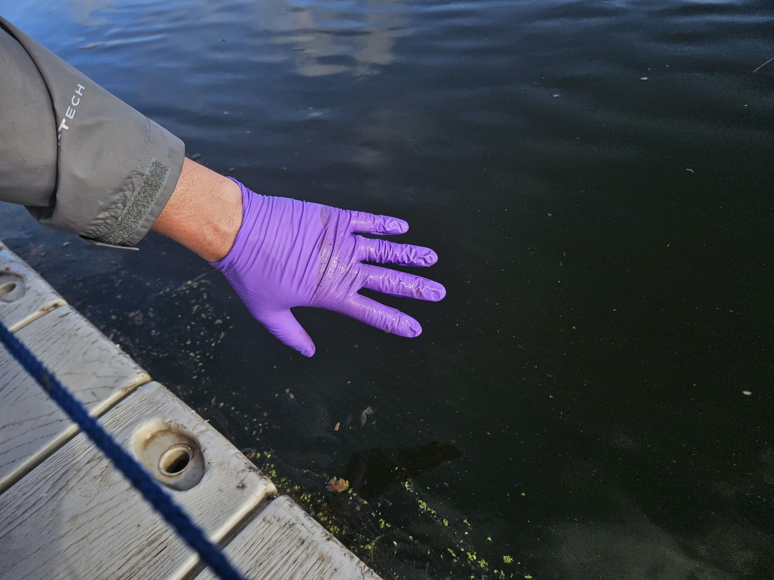
High levels of sediment in the Raritan River at Rutgers Boathouse stain John’s gloves as he takes a sample. Photo credit: Danielle Bongiovanni.
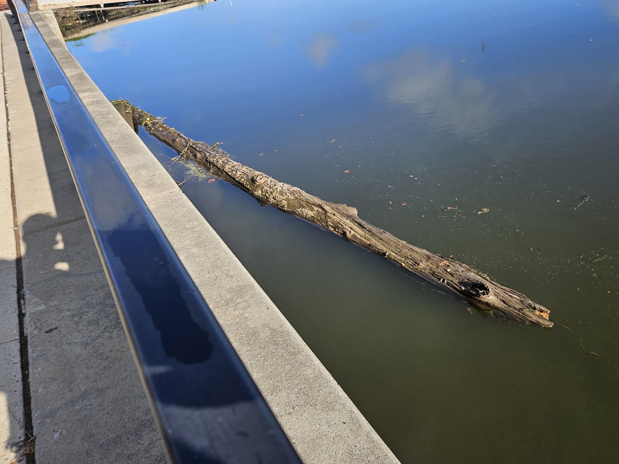
A log blocks outflow from New Brunswick into the Raritan River. Photo credit: Danielle Bongiovanni.
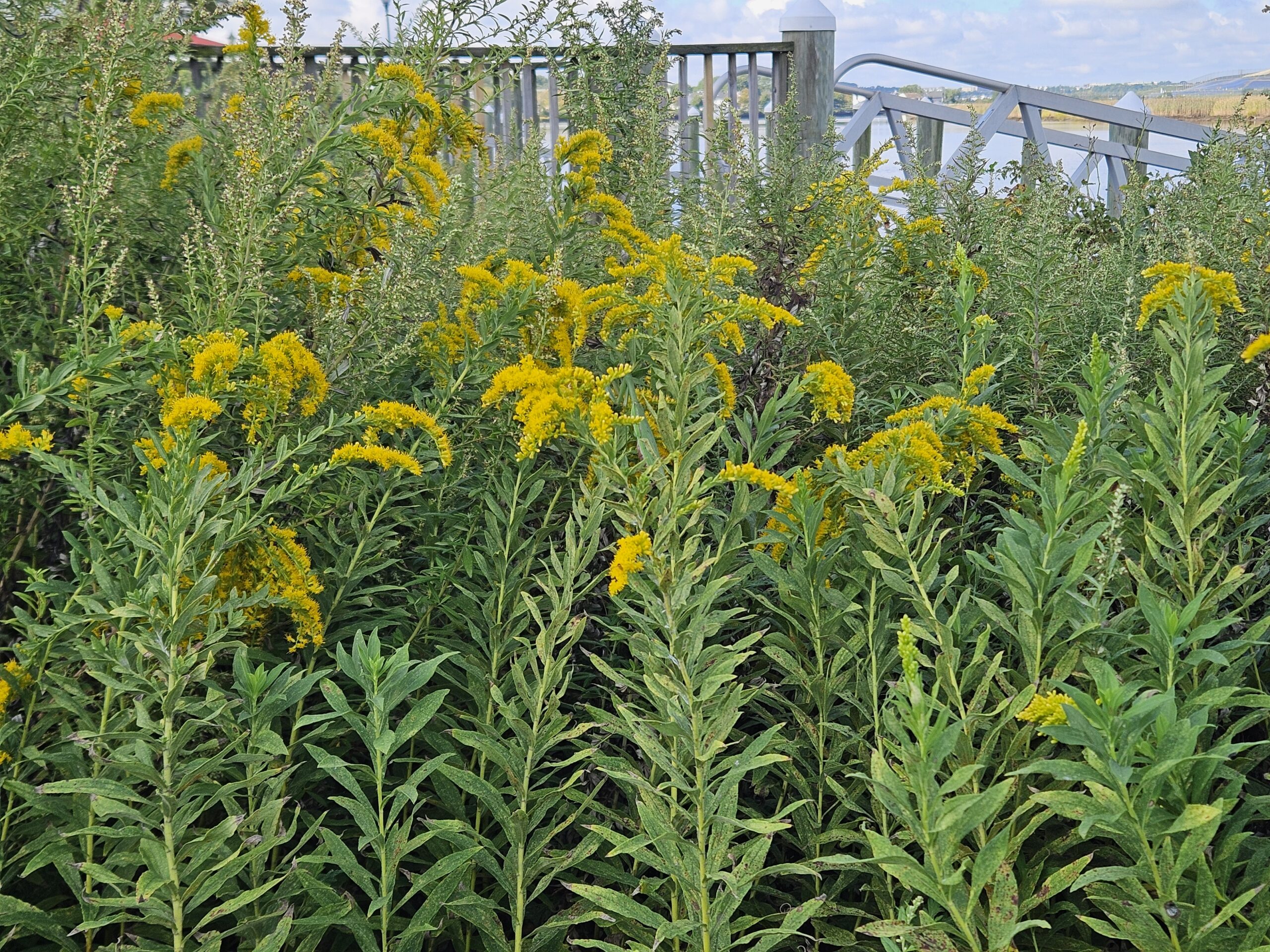
A sunny day at Ken Buchanan Waterfront Park brings out the brillant yellow flowers of seaside goldenrod (Solidago sempervirens). Photo credit: Danielle Bongiovanni.
A helicopter inspects power lines over Sayreville. Photo credit: Danielle Bongiovanni.
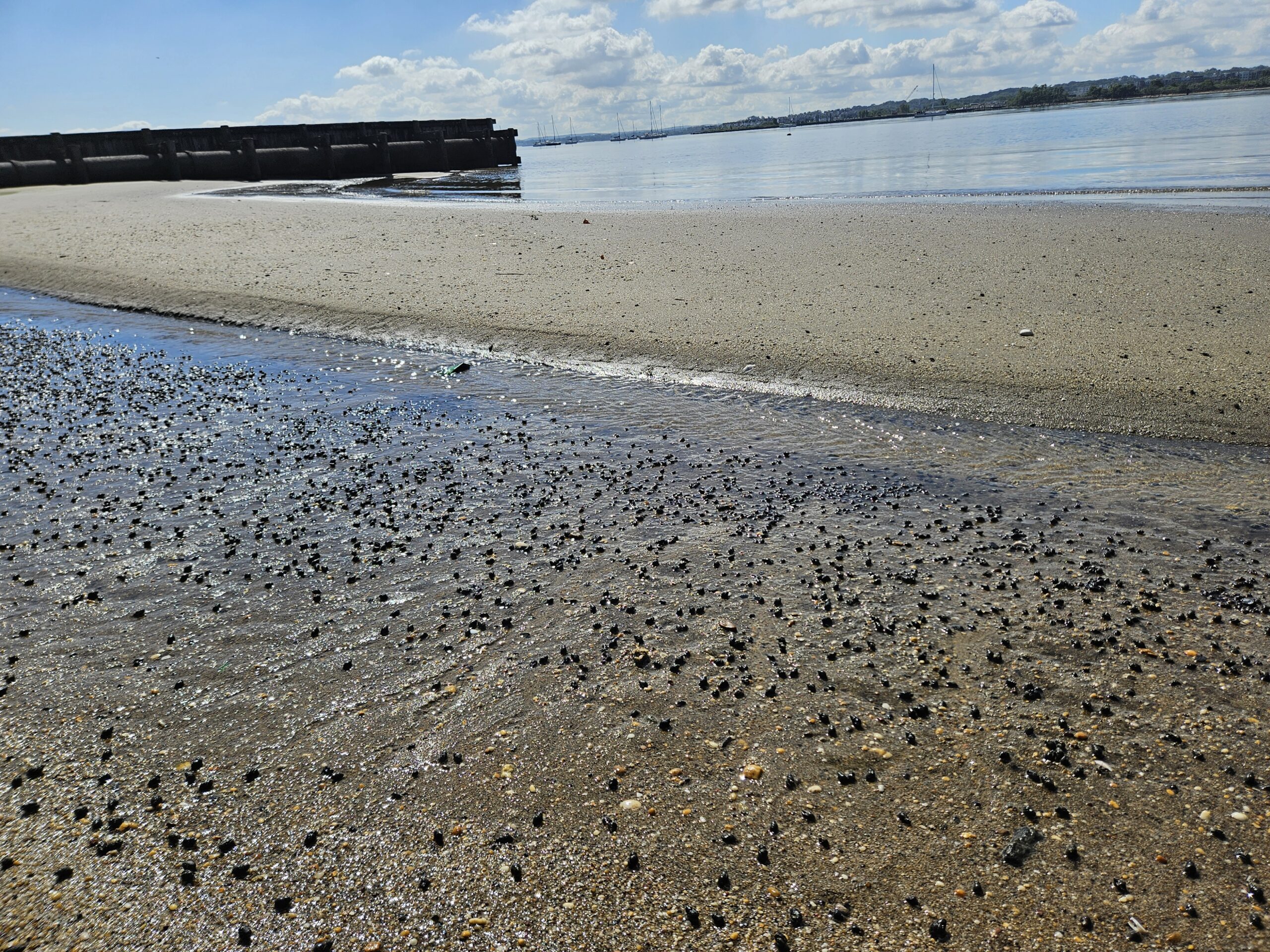
A sandbar blocks snails from being carried out with the tide in Perth Amboy. Photo credit: Danielle Bongiovanni.
Sofi patrols the Perth Amboy shoreline for litter. Unfortunately, baby wipes spilling out of the Combined Sewer Outfalls (CSO’s) are the most common kind of litter in the 2nd street park. A combined sewer system is one in which the sewage and the stormwater flow together in the same pipes. In normal weather, it all gets treated. But in stormy weather, much of the sewage gets washed into Raritan Bay. This is is probably why we saw one of the worst results of the season in Perth Amboy on Thursday. Photo credit: Photo credit: Art Allgauer.
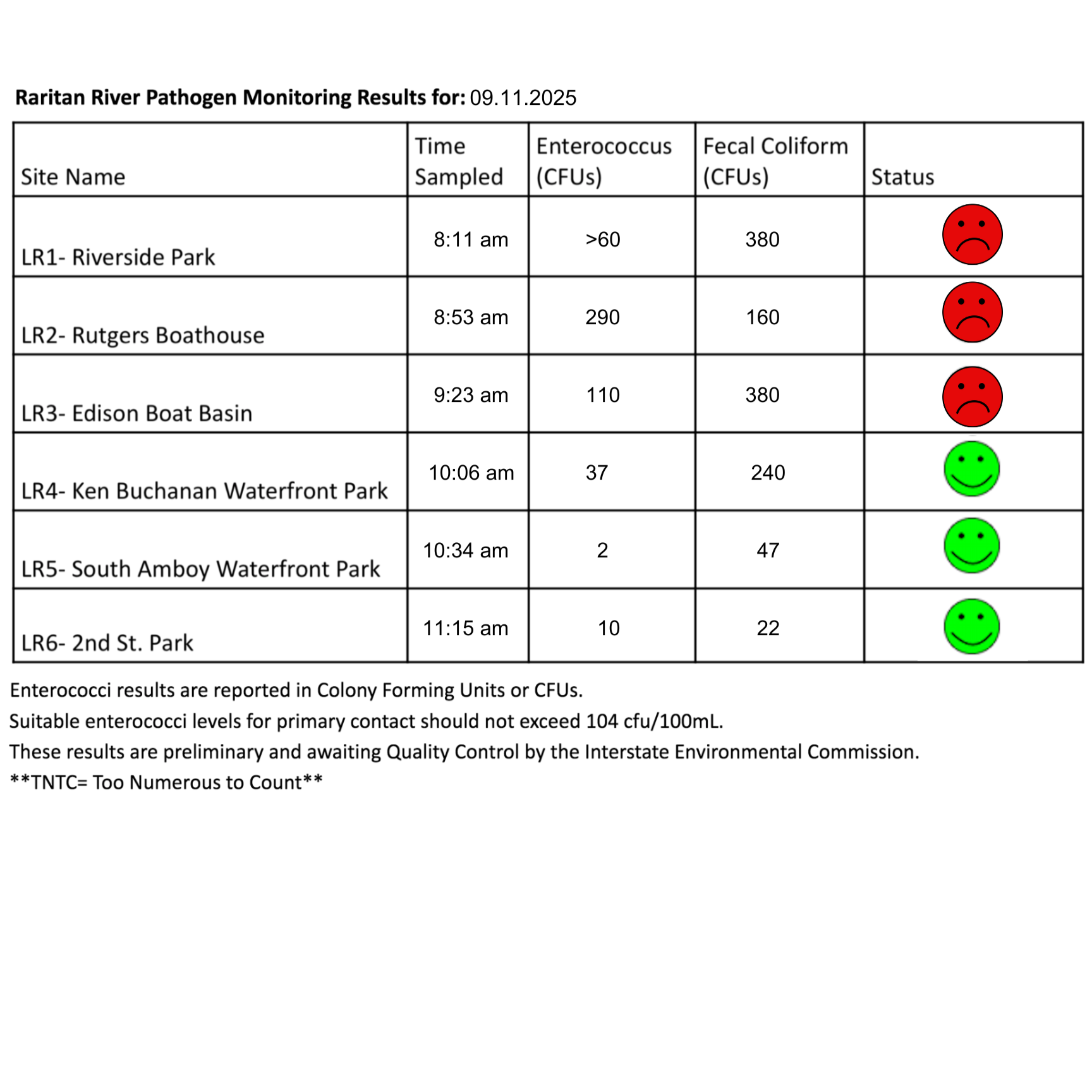
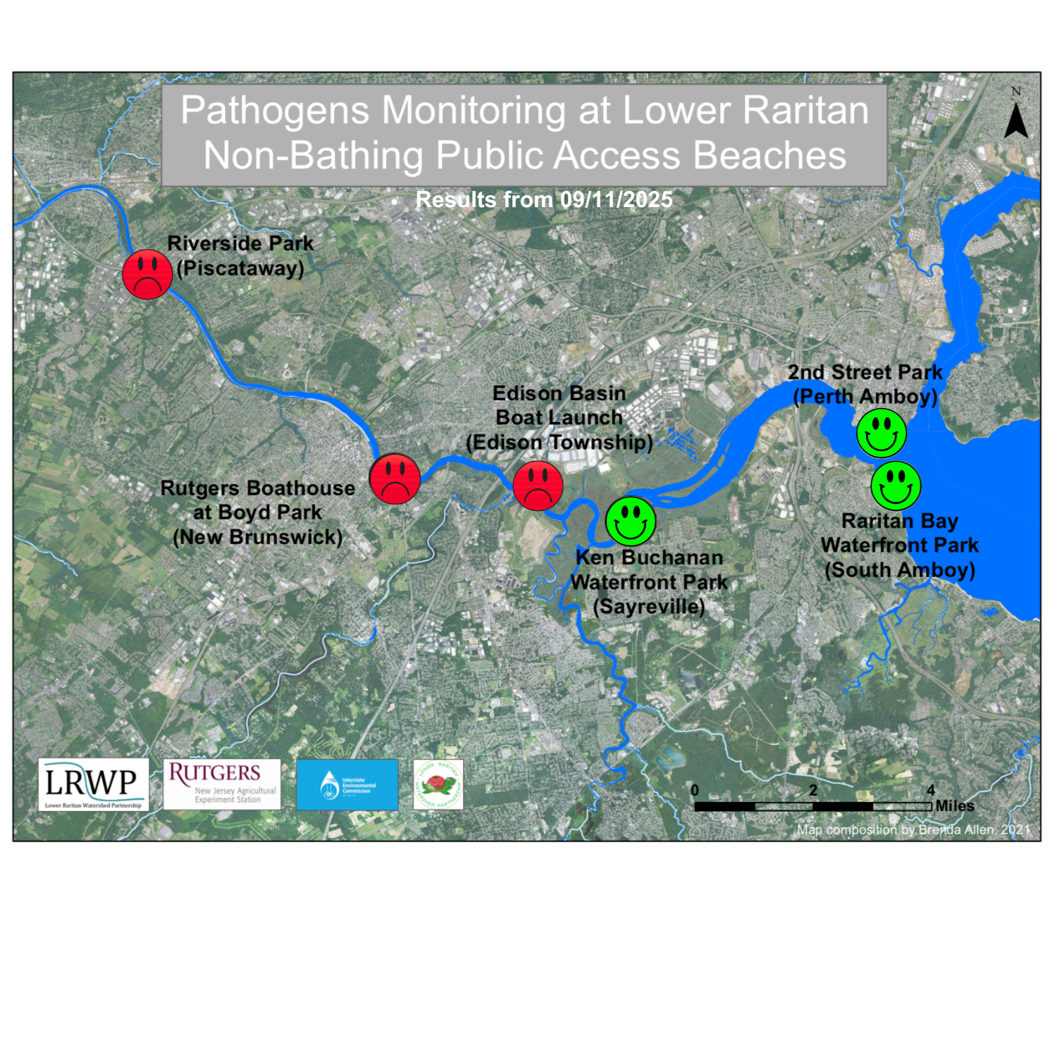
The second pathogen monitoring session of the month took place on Thursday, September 11th. Each week during the summer, from May to October, the Lower Raritan Watershed Partnership and Rutgers Cooperative Extension of Middlesex County run a volunteer-based monitoring program along the Raritan River. We collect water quality samples at six non-bathing public access beach sites, provide our samples to the Interstate Environmental Commission for analysis in their laboratory, and report the results to the public. Our mission is to share this data with the community and partners to ensure the safe use of the Raritan river for all.
Our lab results for water quality samples taken on Thursday, September 11th, 2025 show Enterococcus bacteria levels exceeding the EPA federal water quality standard of 104 cfu/100mL at three of our monitoring sites this week. Problem sites would be indicated by red frowns on the map and chart which includes: Rutgers Boat House (New Brunswick), Edison Boat Basin(Edison Township), and Ken Buchanan Waterfront Park (Sayreville). Riverside Park (Piscataway) had inconclusive results. Out of an abundance of caution, a red fown has been assigned to it. Green smiles on the chart and map indicate the sites with bacteria levels safe for recreation, and include the following: Raritan Bay Waterfront Park (South Amboy), and 2nd Street Park (Perth Amboy).
Pathogens/Enterococci levels are used as indicators of the possible presence of disease-causing bacteria in recreational waters. Such pathogens may pose health risks to people coming in primary contact with the water (touching) through recreational activities like fishing, kayaking or swimming in a water body. Possible sources of bacteria include Combined Sewer Overflows (CSOs), improperly functioning wastewater treatment plants, stormwater runoff, leaking septic systems, animal carcasses, pet waste, wildlife waste, and runoff from manure storage areas.
Our goal in reporting these results is to give residents a better understanding of the potential health risks related to primary contact during water-based recreation. If you are planning on recreating on the Raritan this weekend, make sure to stay safe and wash up after any activities!
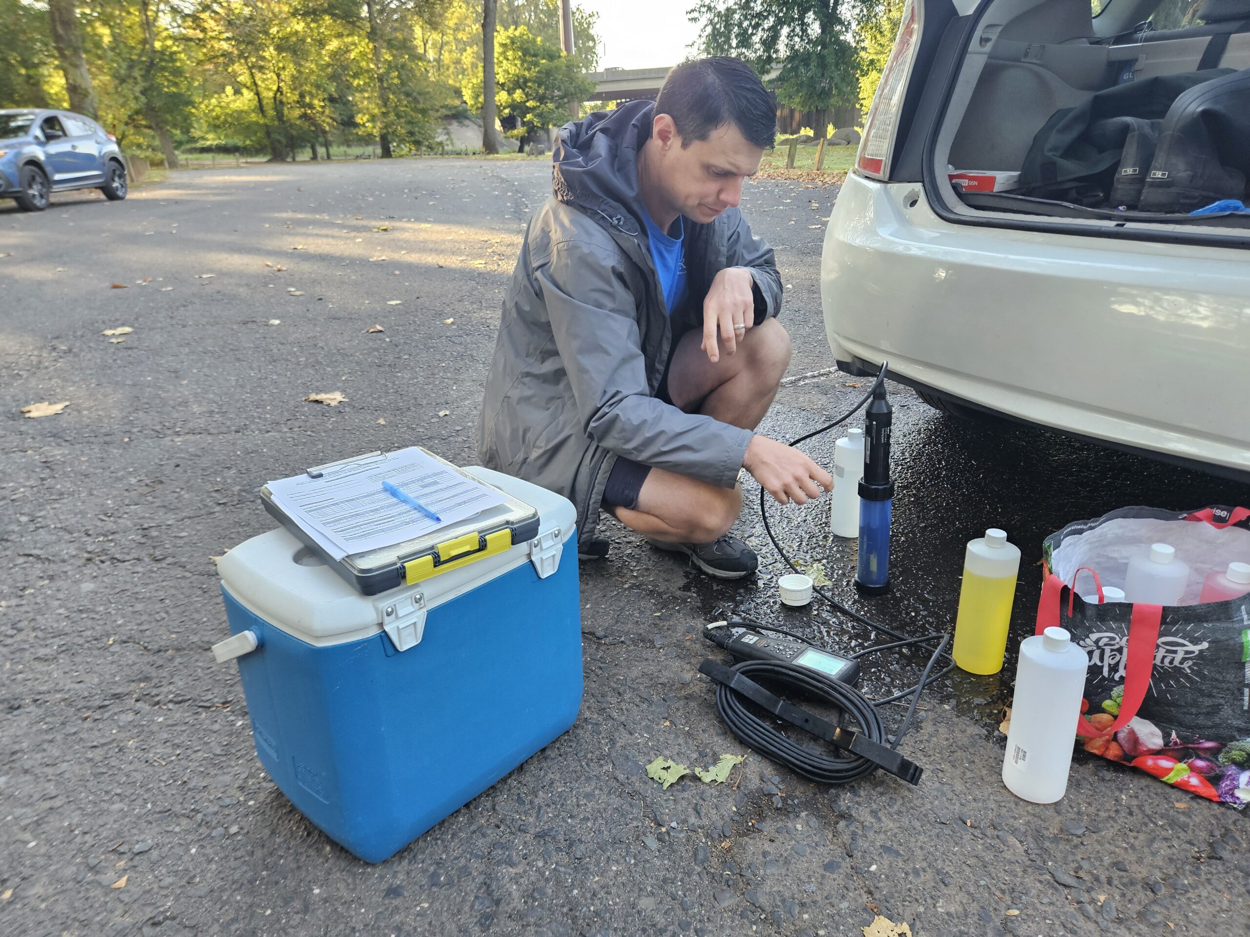
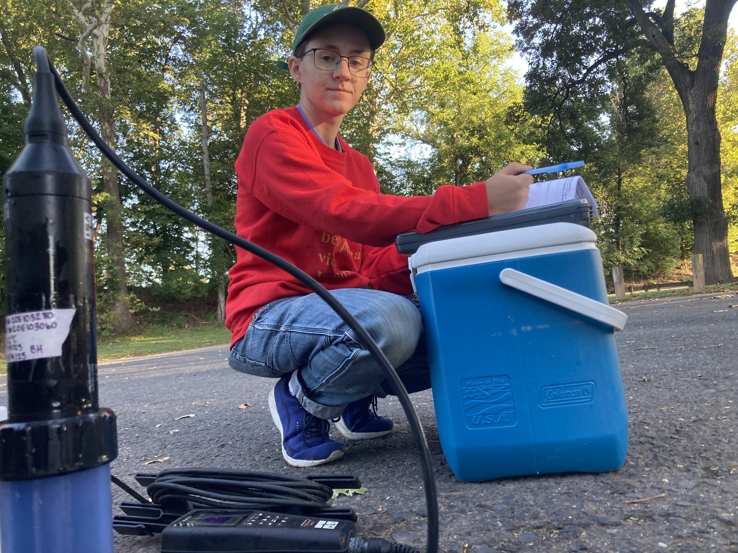
Before pathogen monitoring can begin, the sonde is calibrated. Preparations include confirming the sonde accurately measures pH by submerging it in different buffers. The yellow solution is neutral with a pH of 7. Photo credit: Danielle Bongiovanni.
Our partners at the Interstate Environmental Commission provide us with thorough instructions on how to calibrate the sensors on the sonde. Rather than working off of memory, we prefer to have one person read the instructions aloud to avoid mistakes–in this, case Danielle is reading the instructions and recording the results of the calibration. Photo credit: J.M. Meyer.
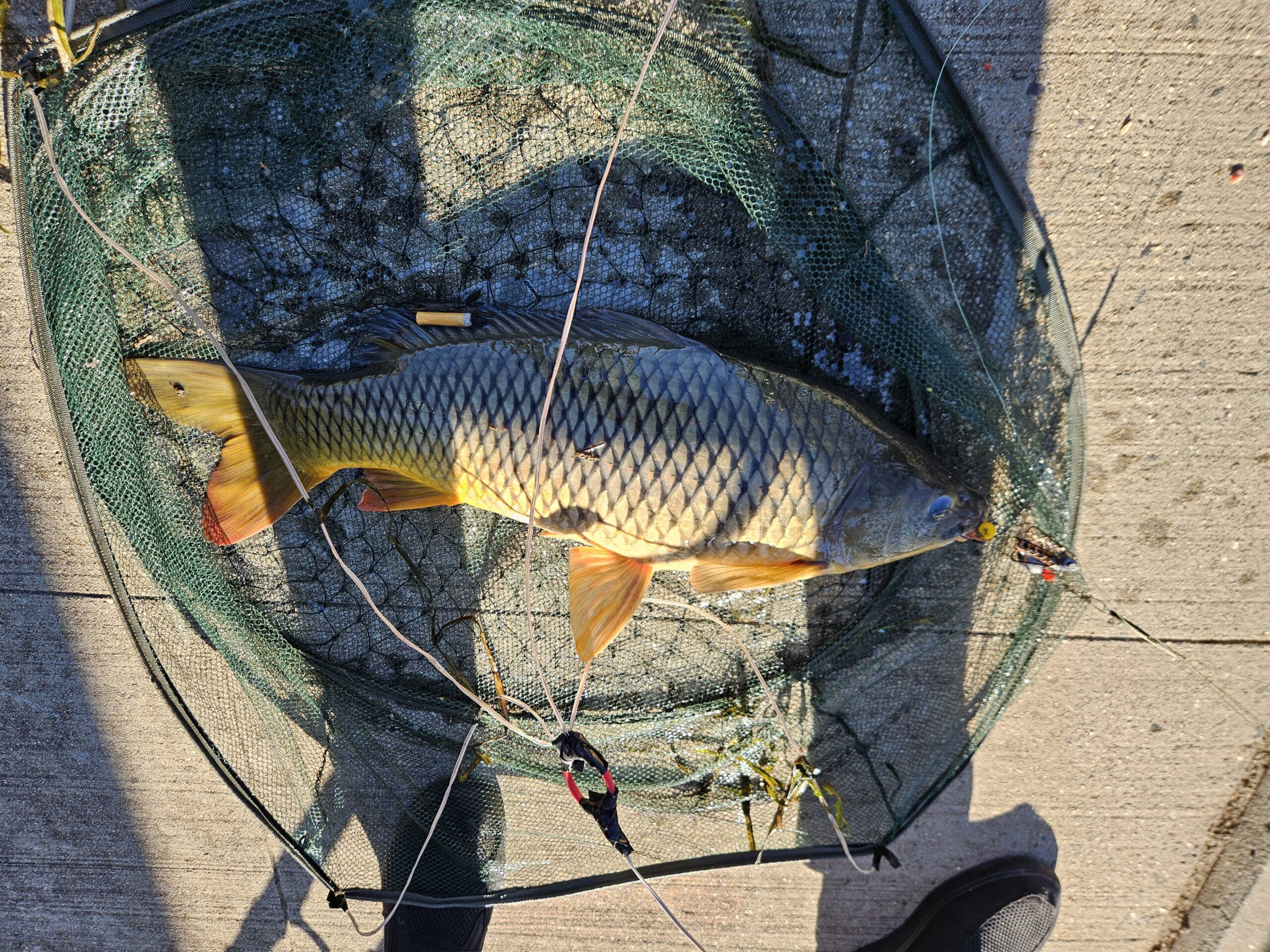
Fishermen at Rutgers Boathouse reeled in a massive common carp (Cyprinus carpio), an invasive freshwater fish commonly found in the Raritan River. With it came a cigarette butt, illustrating how the trash tossed into the water does not instantly break down. Photo credit: Danielle Bongiovanni.
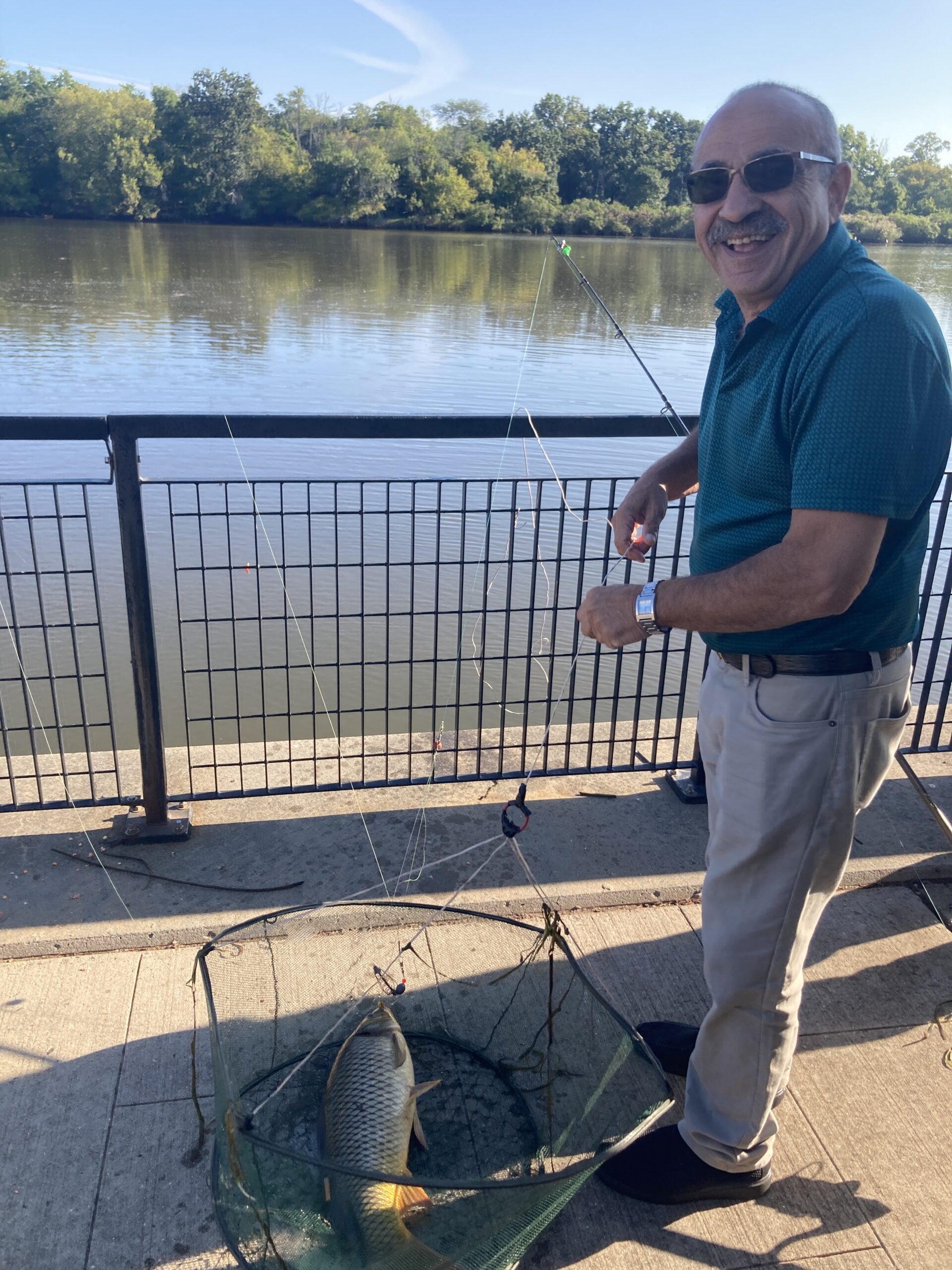
A happy fisherman with his netted carp. Our proximity to the river means people often fish before or after work. Photo credit: J.M. Meyer.
In Edison, as the tide rolled in, we witnessed no less than seven egrets riding fallen logs upstream against the current. Photo credit: Arthur Allgauer.
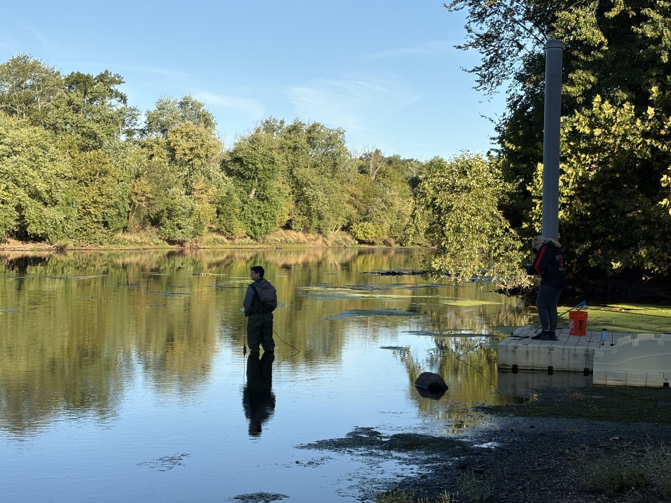
Gloves, sonde, and sample: John returns from wading into the waters in South Amboy. Photo credit: Arthur Allgauer.
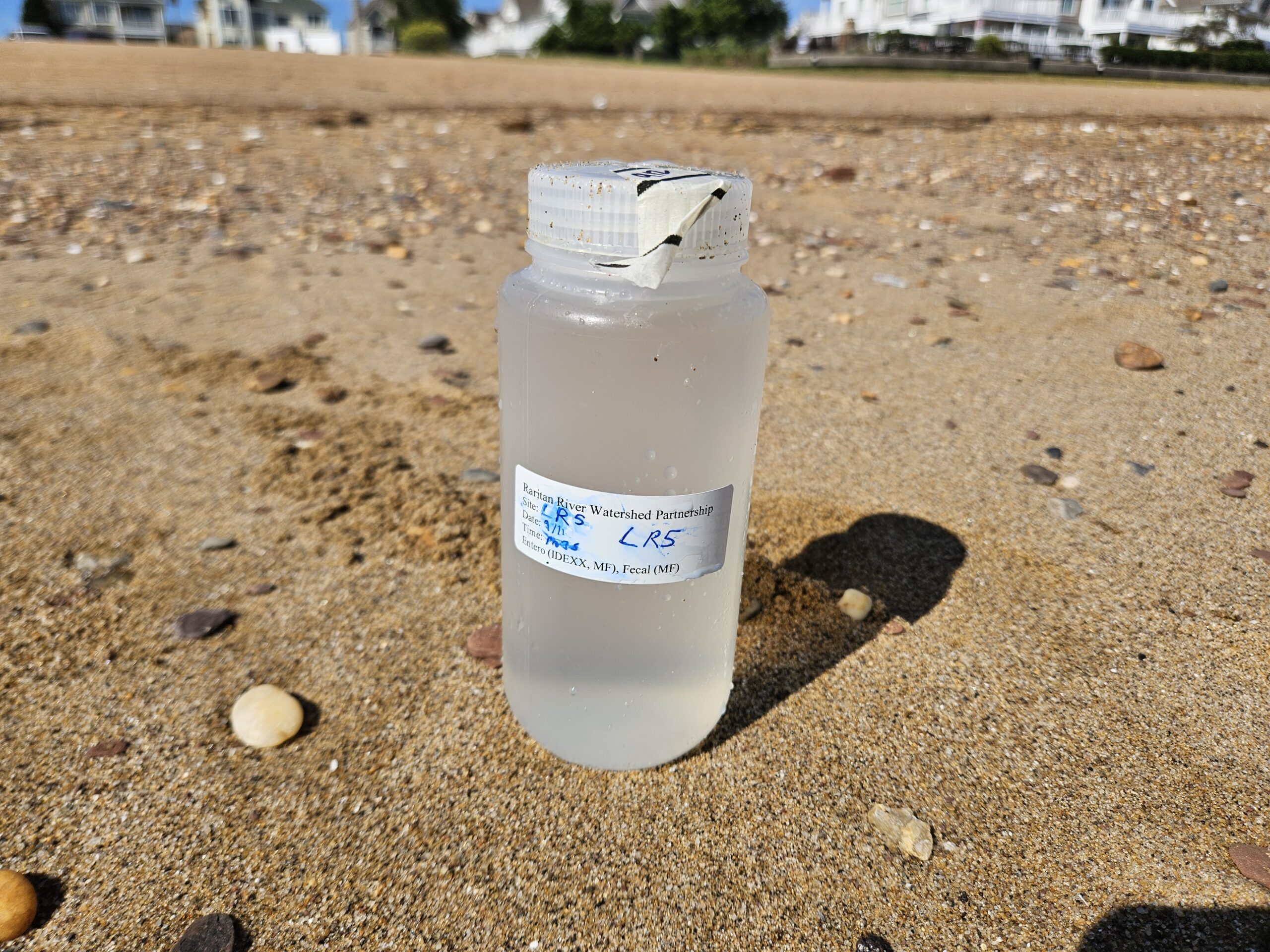
The bottles used to collect samples are sterilized beforehand. The tape on the lid remains intact until a gloved volunteer is about to use it. This reduces the chance of contamination skewing the lab results. Photo credit: Danielle Bongiovanni.
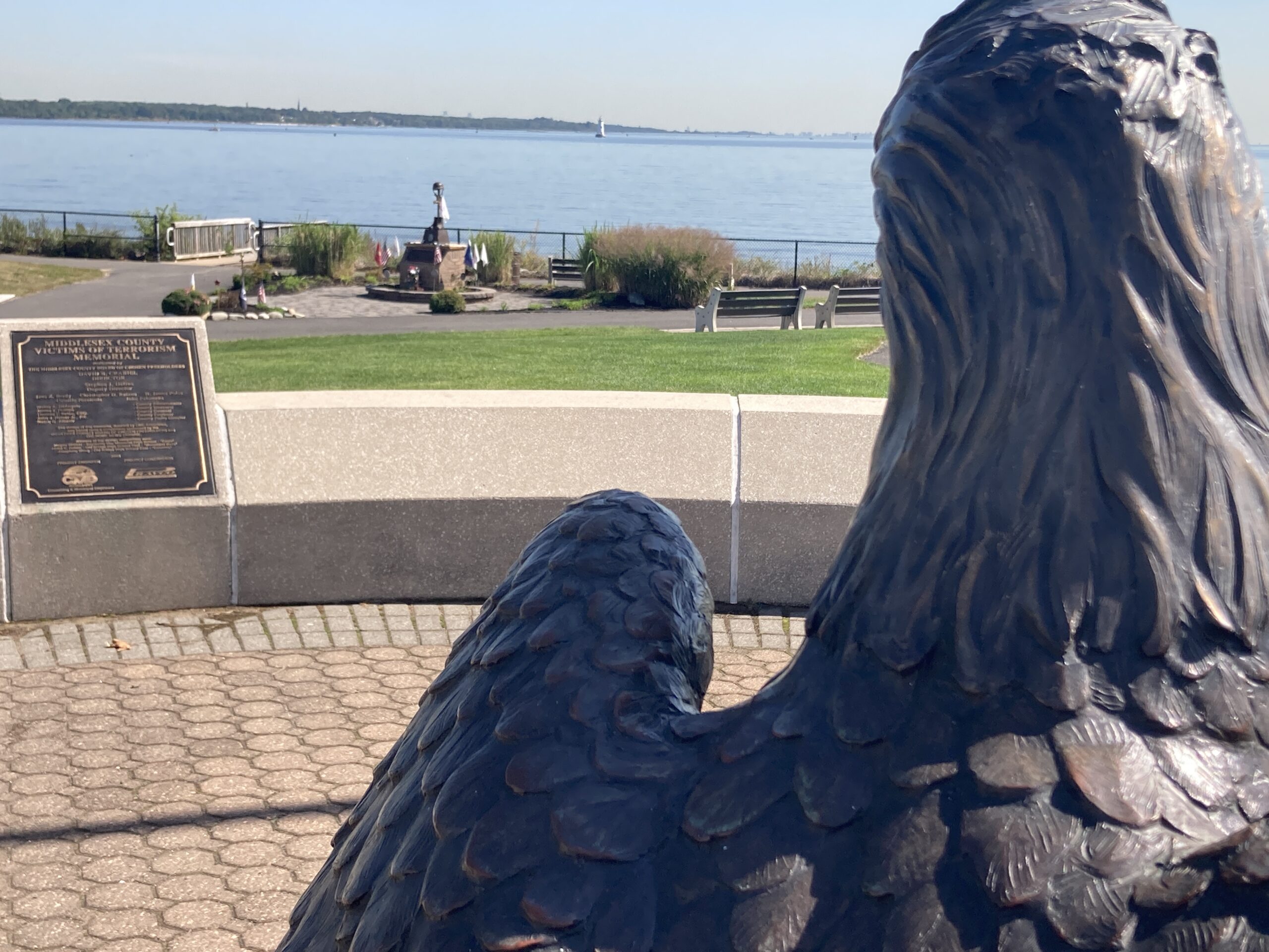
In remembrance of Sepetember 11th, we stopped at the Middlesex County memorial in South Amboy. This eagle sculpture stares across Raritan Bay and across Staten Island — the Twin Towers were once visible in the distance. Photo credit: J.M. Meyer.
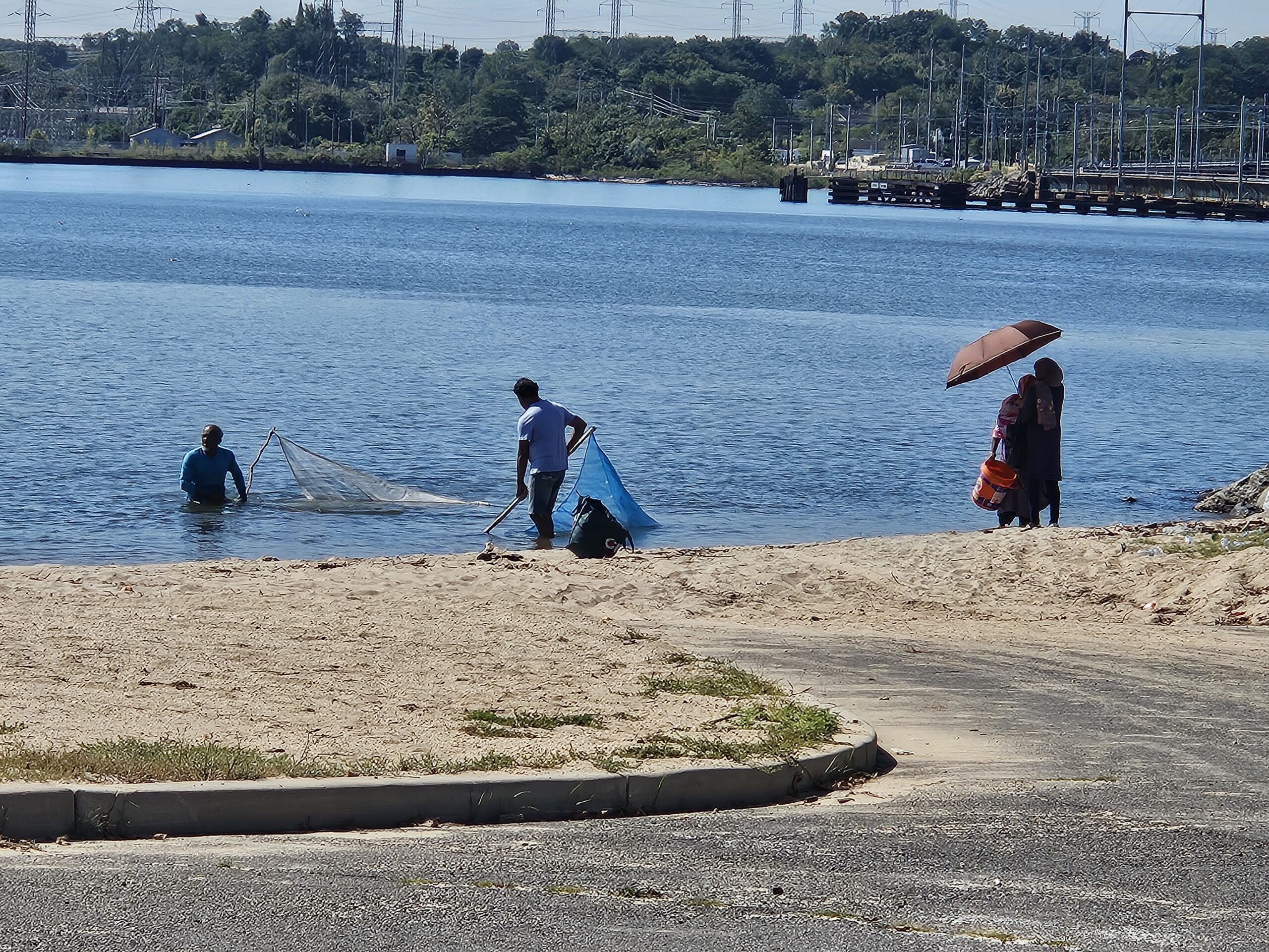
Beachgoers at 2nd St. Park deploy a seine net to catch fish and shellfish fishing for consumptions remains common throughout the Raritan watershed, and reminds us of the importance of keeping our waters clean. Photo credit: Danielle Bongiovanni.
On July 9, 2025, LRWP Board Member Heather Fenyk joined the 2024-2025 class of New Jersey Department of Environmental Protection Watershed Ambassadors at Monmouth Battlefield to celebrate the graduation of these special humans. We were thrilled to be recognized as the NJDEP AmeriCorps Watershed Ambassadors Program “partner of the year.” The LRWP’s annual Green Brook Clean-up has grown to engage eight (8) municipalities through the partnership work with these Watershed Ambassadors – we should be thanking them!
A heartfelt thank you to the graduating 2024-2025 cohort: Olivia Stettler: WMA 1, Team Leader Jenna Black: WMA 2 Peyton Curley: WMA 3 Emilie Wigchers: WMA 4 Isaiah Leach: WMA 5 Toni L. Tamberelli: WMA 6 Kaitlyn Pinto: WMA 7 Daniel Magda: WMA 8 Brianna Casario: WMA 9, Team Leader Claire Paul: WMA 10, Team Leader Mike Sherr: WMA 11 Forrest Jennings: WMA 13 Cameron Shapiro: WMA 14, Team Leader Morgan Crouch: WMA 15, Team Leader Courtney Lacombe: WMA 16 David Ferrara: WMA 17 Jessie Lisanti: WMA 20 Emily Vasquez: SWP North Sheyla Casco: SWP Central Gina Freshcoln: SWP South
The AmeriCorps NJ Watershed Ambassadors Program is administered by the New Jersey Department of Environmental Protection, Division of Water Monitoring, Standards and Pesticide Control. The goals of the program are to promote watershed stewardship through education and direct community involvement, and to monitor stream health through performing visual and biological assessments. Individual AmeriCorps members are assigned to each of New Jersey’s 20 watershed management areas (WMAs) to serve as “Watershed Ambassadors” to their watershed communities. In addition to the 20 full time Watershed Ambassadors, 3 part-time Source Water Protection Ambassadors are assigned to a region in Northern, Central, and Southern NJ. The Source Water Protection Ambassadors serve 900 hours from September – May, conducting education and stewardship projects that relate to sources of drinking water.
Dear Governor Murphy and the NJ Department of Environmental Protection –
I am writing on behalf of the Lower Raritan Watershed Partnership (LRWP) regarding Williams Northeast Supply Enhancement (NESE) Pipeline project. The LRWP is opposed to construction of a fracked gas-powered compressor station in Franklin Township, including 3.5 miles of connecting pipeline through a portion of the Lower Raritan Watershed (New Jersey Watershed Management Area 9) in Old Bridge Township. The LRWP is also opposed to a core component of this project, the proposed 23.4-mile-long, 26-inch-diameter pipeline loop (called the “Raritan Bay Loop”) extending from the Middlesex County coast crossing under Raritan Bay and New Jersey and New York State marine waters.
The LRWP formed in 2015 to address industrial pollutants that left a legacy of contamination in the Raritan River and the Lower Raritan Watershed. Our Lower Raritan Watershed communities have worked hard to restore landscapes destroyed by decades of industrial dumping and toxic pollution. Many of these areas are now thriving, and others are natural Heritage sites, part of the NY/NJ Harbor and Estuary, which provide habitat for federally threatened and/or endangered species.
The LRWP’s most specific concern is with the project’s impact to the marine ecosystem, including the benthic habitat of Raritan Bay. Estimates indicate that as many as 14,100 acres of Raritan Bay may be impacted, with potential serious adverse impact on the Bay’s fisheries. These fisheries include many species of anadromous fish with established spawning grounds in the up-stream Raritan River area, and vulnerable populations of horseshoe crabs, sea turtles, and many other marine mammals.
The LRWP respectfully requests that NJDEP deny permits for the NESE Pipeline project that would result in significant environmental degradation of our Lower Raritan Watershed and Raritan Bay.