In the opening scene of Mark Ruffalo’s devastating new true-story legal thriller Dark Waters, released this week in New Jersey theaters, we watch as a car travels rural roads to a swimming hole. In the dark of night three teenagers exit the car near a “no trespassing” sign, jump a fence, and dive in. The camera pans to signs marked “containment pond,” where chemical byproducts of Dupont’s manufacturing plants – specifically Perfluorooctanoic acid or PFOA – are ostensibly “contained”.
The year is 1975. PFOAs are unregulated. Things end badly. We soon learn that PFOA is related to an abundance of health risks. The film traces a decades-long corporate cover-up of these risks, as well as loss of life and tremendous suffering. The film also makes clear how exceedingly difficult it is to contain toxic pollutants.
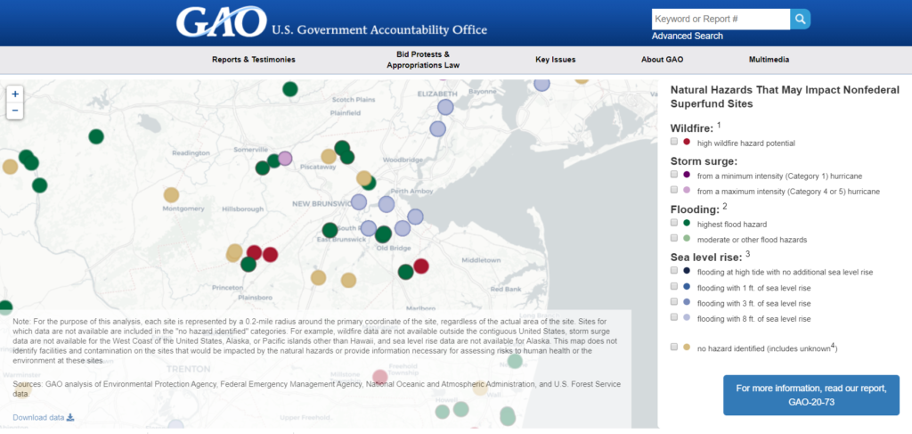
The issue of historic pollutant containment is the focus of a report released last month by the US Government Accountability Office that identifies the nation’s Superfund sites deemed most “at risk” of climate crises including flooding, coastal inundation, and wildfire. Of the 945 sites on the GAO list, 24 are in our 352-square mile Lower Raritan Watershed. That’s an incredibly disproportionate 4% of the most at-risk toxic sites in the United States. Our almost 900,000 watershed residents don’t have to travel rural roads to encounter pollutant hazards, they are proximate to where we live and work. More info on the GAO report, and a list of these sites, is on the LRWP website.
GAO-identified Superfunds in the Lower Raritan that are at-risk of natural hazards impacts (2019)
Of course the GAO only looks at Nonfederal Superfund sites. Here’s a map of all Known Contaminated Sites (KCS) in the watershed, many more of which are likewise at risk.
Not surprisingly, the concentrated band of sites that runs through the middle of the watershed traces along the Raritan River and feeder waterways. Our challenge will be containment of hazards impacts, particularly tough when stilling ponds and uses are proximate to flooded waters.
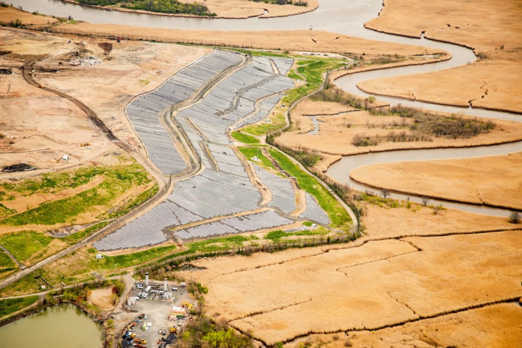
One of many Raritan River-adjacent landfills/Superfund sites at-risk of flood impacts Photo by Alison M. Jones, No Water No Life – taken during a LightHawk flight, April 2019
At-risk Superfund sites in the Lower Raritan Watershed include:
Federal Creosote, Manville
CPS/Madison Industries, Old Bridge
American Cyanamid, Bridgewater
Fried Industries, East Brunswick
Kin-Buc Landfill, Edison
Global Sanitary Landfill, Old Bridge
Renora Inc., Edison
Brook Industrial Park, Bound Brook
JIS Landfill, South Brunswick
Chemical Insecticide Corporation, East Brunswick
Monroe Township Landfill, Monroe
Sayreville Landfill, Sayreville
Chemsol, Piscataway
South Brunswick Landfill, South Brunswick
Myers Property, Franklin Township
Evor Industries, Old Bridge
Horseshoe Road, Sayreville
Higgins Farm, Franklin Township
Cornell Dubilier, South Plainfield
Atlantic Resources, Sayreville
Franklin Burn, Franklin Township
Raritan Bay Slag, Old Bridge/Sayreville
Woodbridge Road Dump, South Plainfield
Burnt Fly Bog, Marlboro
Concerns of risks posed by legacy pollutants, particularly in light of sea level rise and climate change, have long been on the LRWP’s radar. These concerns motivate our grant-seeking to protect inland communities from potentially toxic sediment deposition through tidal marsh restoration, and watershed partners will receive support through the National Fish and Wildlife Foundation to develop an engineering plan with a permit-ready design to start to protect vulnerable South River residents from riverine flooding and storm flows, and what we already know are toxic flows of sediment into their neighborhoods.
In coming months the LRWP will analyze the GAO and other data, prioritizing focus areas, and wrestling with what the Superfund report means in terms of restoration and resiliency planning for our watershed going forward. We will also be working to develop a strategy to best position ourselves to hold state and federal entities accountable for clean-up, protecting our communities, and similar.
A female cardinal fluffs her feathers and settles in to wait out a midwinter snowstorm
The autumn light gradually dims, as it follows its well-worn path deeper into December. Like a long circular tunnel with a vanishing point, the swirling colors fade away until they disappear, engulfed by dark shadows on the threshold of winter.
From this darkness, caused by the celestial despair of the planets, new light instantly begins to grow while shadows hidden on the far side of light begin to withdraw.
The apparent low orbit of the sun across the sky in winter produces the longest shadows. Shadows, which when measured at the height of the day, over time reflect the ebb and flow of the seasons. It is as if the shadows whispered their secret to early sky gazers, bestowing upon them, the gift of predicting the future.
When the position of stars and planets were noted in association with the occurrence of the longest and shortest shadows, a living calendar was discovered. Sunrise and sunset defined a day, full moon a month and the longest shadow to the longest shadow was a year. The concept of time was now measurable and the occurrence of future events predictable; predictability being an innate need and prerequisite to human survival.
As the primitive calendar became more refined, certain times were marked for celebration. Surely, the longest and shortest days were noted and given special attention. Humans will bridge gaps in knowledge with mythology and paleo societies revolved around myths used to explain natural phenomena.
In the northern latitudes, winter was a critical time of survival. During midwinter the sun appeared to stand still. If you look at a perpetual calendar of sunrise and sunset, the change in day length is minimal during that period.
Many were the rites and ceremonies during that period of darkness. Some gave rise to modern celebration when religious holidays overlaid pagan rituals. Druids burned a yule log to encourage the return of light. Holly, which was evergreen, was given as a sign of life. The birth of light marked a new year, a time to plan and celebrate future success.
I take comfort in celebrating the shortest day and birth of light with a campfire, lighting a cattail and roasting a piece of venison on the glowing coals. This day is my paleo New Year celebration, identifying more with primitive ancestors than ethnic DNA. January first is of no consequence.
To hunt with a traditional bow and arrow and bring a deer to ground to share with the clan is the ultimate act of caring and community. It becomes a communion of spirit and flesh where the animal is assimilated, a sign of respect for its sacrifice. It also transcends time and allows me to share in the emotions felt by my ancestors who looked to the sky and listened to the whispering shadows for guidance and survival.
Welcome to winter and new life. Sophisticated calculation of planetary movements indicates that this year winter will arrive December twenty-first at 11:19 am. Like magic, the descent into darkness instantly gives way to the ascent into light.
If nothing else, give a glance up at the stars on the twenty-first. Know the wonder your ancestors felt when they looked to the heavens in awe, their imagination encouraged by the stars and planets moving across the night sky.
A female cardinal turned upside down, perfectly reflects the new year of light ushered in by the midwinter solstice. It is a chance to use the light to see your world from a different perspective and discover all the treasures hidden by unconscious routine and preconception. A legacy of the ancient Roman midwinter celebration of Saturnalia where “social order was turned upside down” while merriment and wild celebration ruled the day.
Author Joe Mish has been running wild in New Jersey since childhood when he found ways to escape his mother’s watchful eyes. He continues to trek the swamps, rivers and thickets seeking to share, with the residents and visitors, all of the state’s natural beauty hidden within full view. To read more of his writing and view more of his gorgeous photographs visit Winter Bear Rising, his wordpress blog. Joe’s series “Nature on the Raritan, Hidden in Plain View” runs monthly as part of the LRWP “Voices of the Watershed” series. Writing and photos used with permission from the author. Contact jjmish57@msn.com. See more articles and photos at winterbearrising.wordpress.com.
Many thanks, and huge congrats, to LRWP Board Member Johnny Quispe for coordinating grant development for support through NFWF’s 2019 Coastal Resilience Fund.
It was announced earlier this week that $249,639 in National Fish and Wildlife Foundation (NFWF) funds will go to develop the “South River Ecosystem Restoration and Flood Resiliency Enhancement Project (NJ)”.
More specifically, these monies will support Princeton Hydro and other watershed partners to:
“Conduct an ecosystem restoration site assessment and design for 165 acres of tidal marshes and transitional forest in New Jersey’s Raritan River Watershed. Project will result in an engineering plan with a permit-ready design to reduce coastal inundation and erosion along about 2.5 miles of shoreline for neighboring flood-prone communities and enhance breeding and foraging habitat for 10 state-listed threatened and endangered avian species.”
More information on the specific awards can be found here:
PARK(ing) Day is one of our favorite days of the year. What’s not to like about taking over hard, impervious parking lot surfaces and re-purposing them into beautiful pop-up-parks for public enjoyment? This year the Lower Raritan Watershed Partnership teamed up with the Rutgers Landscape Architecture Club, New Jersey Chapter of the American Society of Landscape Architects – NJASLA and Garden of Healing Yoga & Wellness to make magic happen in downtown New Brunswick. With thanks to videographer Will Atwater for this recap of the day.
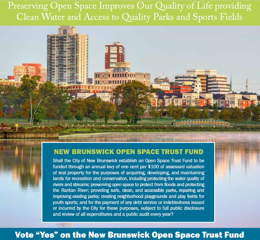
In today’s digital age it is more important than ever to preserve places where children can run, play, and experience nature. A referendum measure on the Nov 5 ballot for New Brunswick residents – for the New Brunswick Open Space Trust Fund – allows residents to vote to preserve open space so as to improve our system of parks, trails, and natural areas in New Brunswick and throughout the watershed.
If approved by the voters, the Open Space Trust Fund would establish a levy on homeowners, costing the average homeowner $27 per year.
Here’s How the Open Space Trust Fund would be Used
• Improving the water quality of rivers and streams;
• Protecting the Raritan River;
• Providing clean, safe parks;
• Providing accessible parks; and
• Repairing and improving existing parks.
Accountability Measures to Ensure Funds are Properly Spent
• Moneys raised for the Open Space Trust Fund would only be used open space projects and nothing else.
• Expenditures from the Open Space Trust Fund would be subject to a public audit every year.
• There would be full public disclosure and review of all expenditures.
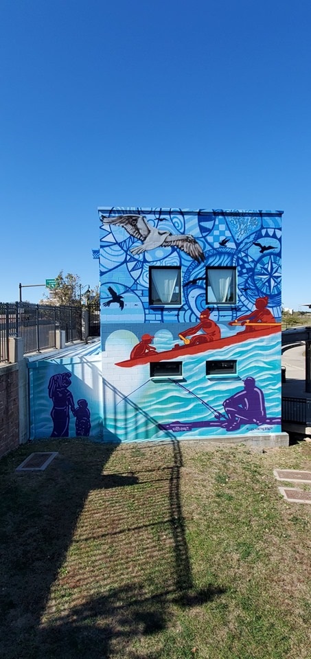
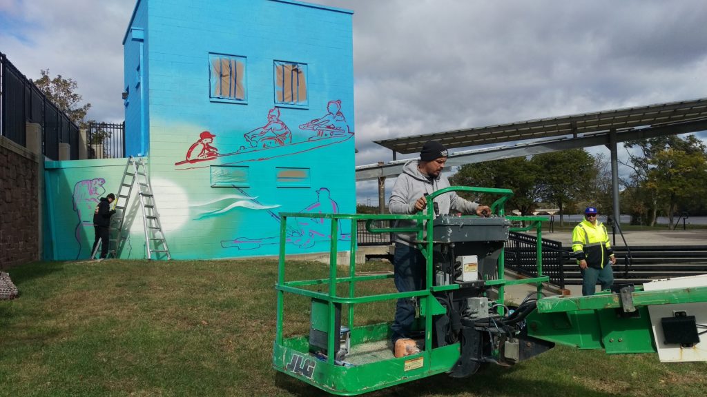
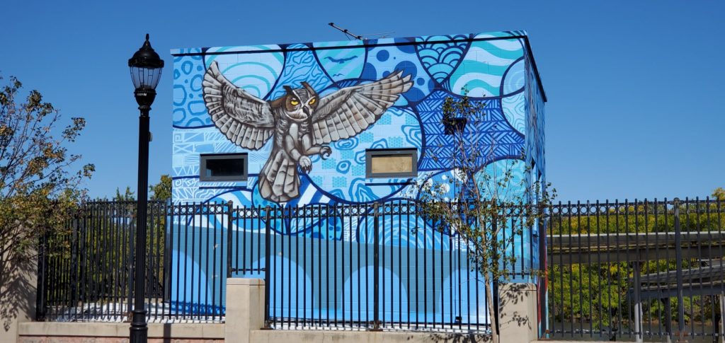
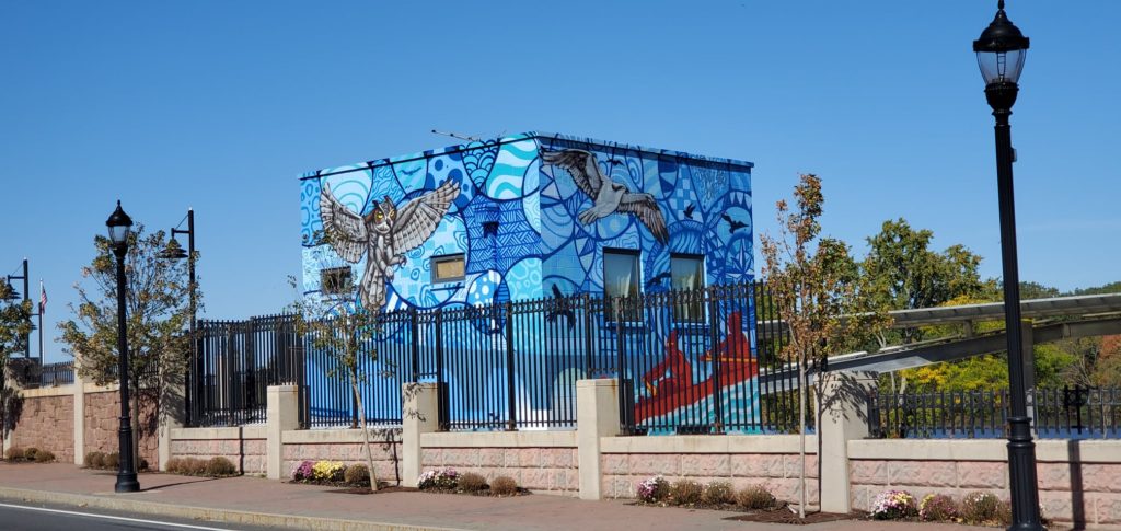
“Raritan River Ways” was created by Leon Rainbow in New Brunswick, in Elmer B. Boyd Park overlooking the amphitheater entrance and Route 18. The mural was created as a commission from the New Brunswick City Government’s response to coLAB Arts’ oral histories collected from individuals who have been boating, fishing, and stewarding the Raritan River for decades.
Route 18 has disconnected New Brunswick from its waterway since the 1950s. Given the high visibility of this mural, we view #RaritanRiverWays is a form of wayfinding for the New Brunswick community and others to reconnect with the Raritan River. We see it as a reminder that we should all #lookfortheriver
Special Thanks to Leon, and to his assistants Radek and John Everyman for this beautiful gift for the City.
Thanks also to Michael Tublin, Keith Jones II, Daniel Swern and John P Keller for all your hard work to make this project possible!
The Nature Conservancy, Sustainable Jersey and The Watershed Institute are again offering “Roots for Rivers” reforestation grants, available now through Friday, December 13th, 2019 for spring 2020 tree planting projects.
The Roots for Rivers Reforestation mini grant program uses the Conservancy’s lessons learned and expertise, coupled with financial incentives, to inspire communities and help catalyze restoration efforts across New Jersey to restore our watersheds through planting native trees and shrubs in degraded floodplain areas and help us to achieve a goal of planting 100,000 trees throughout our state’s floodplains by 2020. To date, over 83,000 materials have been planted (and protected) throughout New Jersey’s floodplains.
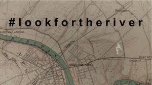
As we travel through our communities, few of us think about the hidden world of streams and rivers that once flowed across the landscape. In the face of climate change and increased precipitation, real life has shown us that stormwater runoff and flooding have intensified. #lookfortheriver is an outreach campaign to engage New Jersey residents in examining changes made to our urban streams and hydrology over time.
Seven years ago my family was without power and heat following Superstorm Sandy. We spent days off from school and work, charging phones in a local fire station, shopping at A&P in the dark, and mopping up our flooded basement apartment. We mourned with our next door neighbor who lost a brother to generator-related carbon monoxide poisoning, and with a colleague who lost a neighbor when the storm’s vicious winds downed a tree.
Today we stop to remember. As we do, we think about those for whom Hurricane-related devastation is fresh. The Bahamas is still assessing damage from Hurricane Dorian. Puerto Rico is still recovering from Hurricane Maria. And just last month Tropical Storm Imelda dumped 43 inches on the Houston, Texas region, causing wide scale flooding, a near repeat of the intense rainfall seen during Hurricane Harvey in 2017.
Imelda and Harvey in particular have brought attention to the likelihood that global climate change will increase the frequency of powerful hurricanes and other storms, and not just in Texas. The northeast has already experienced a 71% increase between 1958 and 2012 in rainfall from intense storms. If the amount of rain that saturated Houston during Harvey or Imelda hit Raritan Bay, our Lower Raritan Watershed riverine communities, including Perth Amboy, South Amboy, Sayreville and South River, would be completely inundated through a combination of storm surge and overland stormwater flow. Although rainfall amounts akin to Harvey are unlikely in our region, we know we must adapt to a wetter, stormier reality.
Intense rainfall is especially devastating in heavily urbanized areas that are characterized by impervious cover, and by streams that are completely culverted, buried, or otherwise covered up. The impact of “hiding” so many of streams causes serious problems. Communities are alienated from their waterways and historic ecologies, habitats are degraded, water quality is compromised, and stormwater runoff and flooding intensify. In the context of intensified precipitation, healthy, open streams play an important role in stormwater management. Open streams slow and control stormwater surge, and stormwater gets absorbed and gradually released by soil and plants.
On this seventh anniversary of Hurricane Sandy the Lower Raritan Watershed Partnership (LRWP) is rolling out #lookfortheriver, a new campaign designed to inspire care for neglected waterways – our lost or forgotten streams – in the context of climate change, intensified urban flooding and sea level rise. We see #lookfortheriver as a way to build social resilience, and to empower communities, particularly folks in harms way with respect to flooding, to value and restore freshwater ecosystems and the environment as community care and resilience.
#lookfortheriver is a way for ordinary citizens to learn how to adapt and prepare for a wetter, stormier future. It involves training in how to read a topographic map, identify watersheds, and understand basic hydrology. It is designed to support residents and communities as they explore their own local landscapes, and to open up discussion about historic patterns of land management and how we might do better.
The LRWP will be gradually building a portfolio of #lookfortheriver offerings. To start, in 2020 eligible entities like libraries, historical societies, museums, civic associations, public agencies, senior centers, and other community groups throughout the state of New Jersey can host a #lookfortheriver outreach session through the New Jersey Council for the Humanities (NJCH) Public Scholars Project.
We are excited about this new initiative, and hope you will join us as we look to the future and #lookfortheriver.
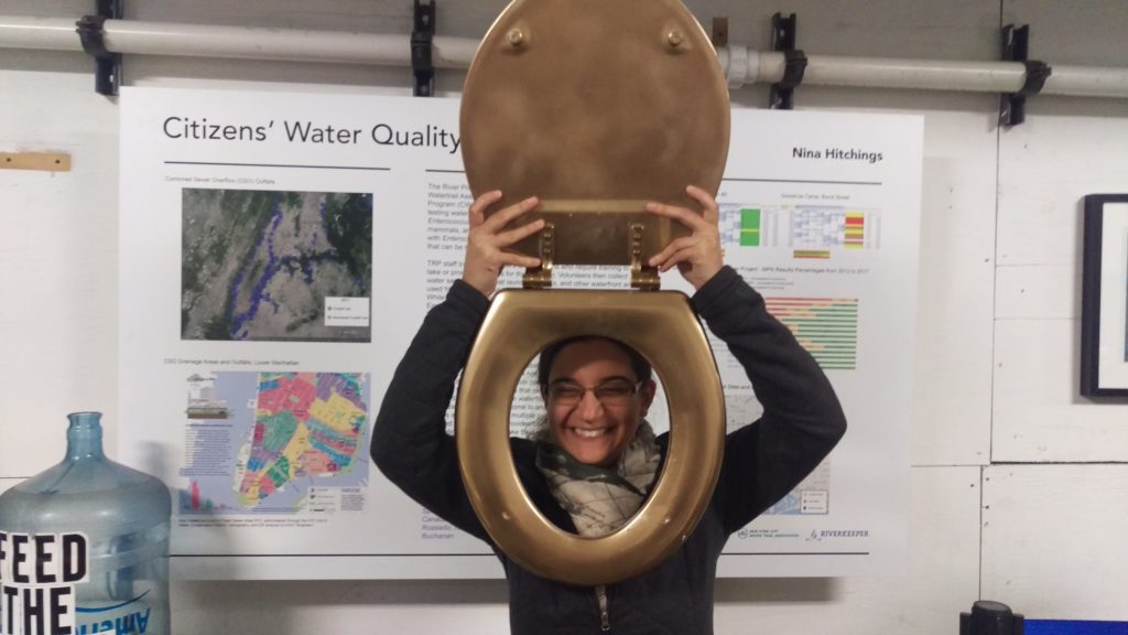
Last week our River was “honored” for having the worst performing waters in terms of bacteria levels of any of the civic science monitoring projects in the NY-NJ Harbor Estuary. Yes, the Raritan River received the 2019 “Golden Toilet” award from NYC’s The River Project.
Click here to see entire season’s results for all 70+ sites, displayed week by week. Click on the map icons here to see results for specific sites.
IEC Environmental Analyst Jessica Bonamusa models the 2019 “Golden Toilet” award
While facing ignominy is not our preferred approach to public engagement, we do hope this helps bring attention and resources to clean up our River. There is nowhere to go but up.
We and our EARTH Center of Middlesex County partners have a lot of work to do in terms of data analysis, but expect more detailed reporting out in the coming weeks.
It is because of the commitment and dedication of our volunteer monitors that we have the data to start pinpointing, and addressing, problems and sources of pollution. A huge THANKS to them for helping us build this program and clean up our Raritan. And a special thanks to the Interstate Environmental Pollution Control Commission for lab analysis.
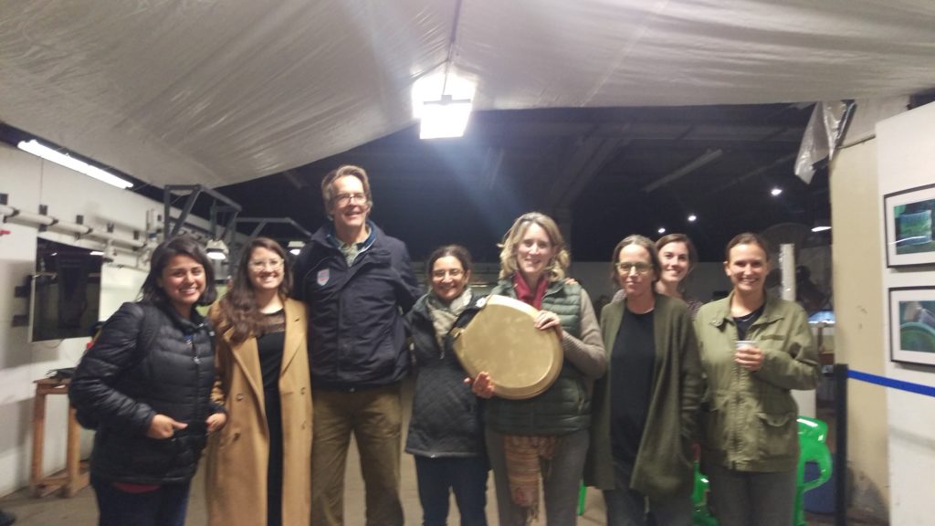
The River Project’s annual awards night, LRWP’s Heather Fenyk receiving the “Golden Toilet” on behalf of the Raritan River