The Lower Raritan Watershed Partnership and Rutgers Cooperative Extension of Middlesex County run a volunteer pathogens monitoring program from May to September every Summer. On Thursdays we collect water quality samples at 6 non-bathing public access beaches along the Raritan River, and report out the results on Friday afternoons.
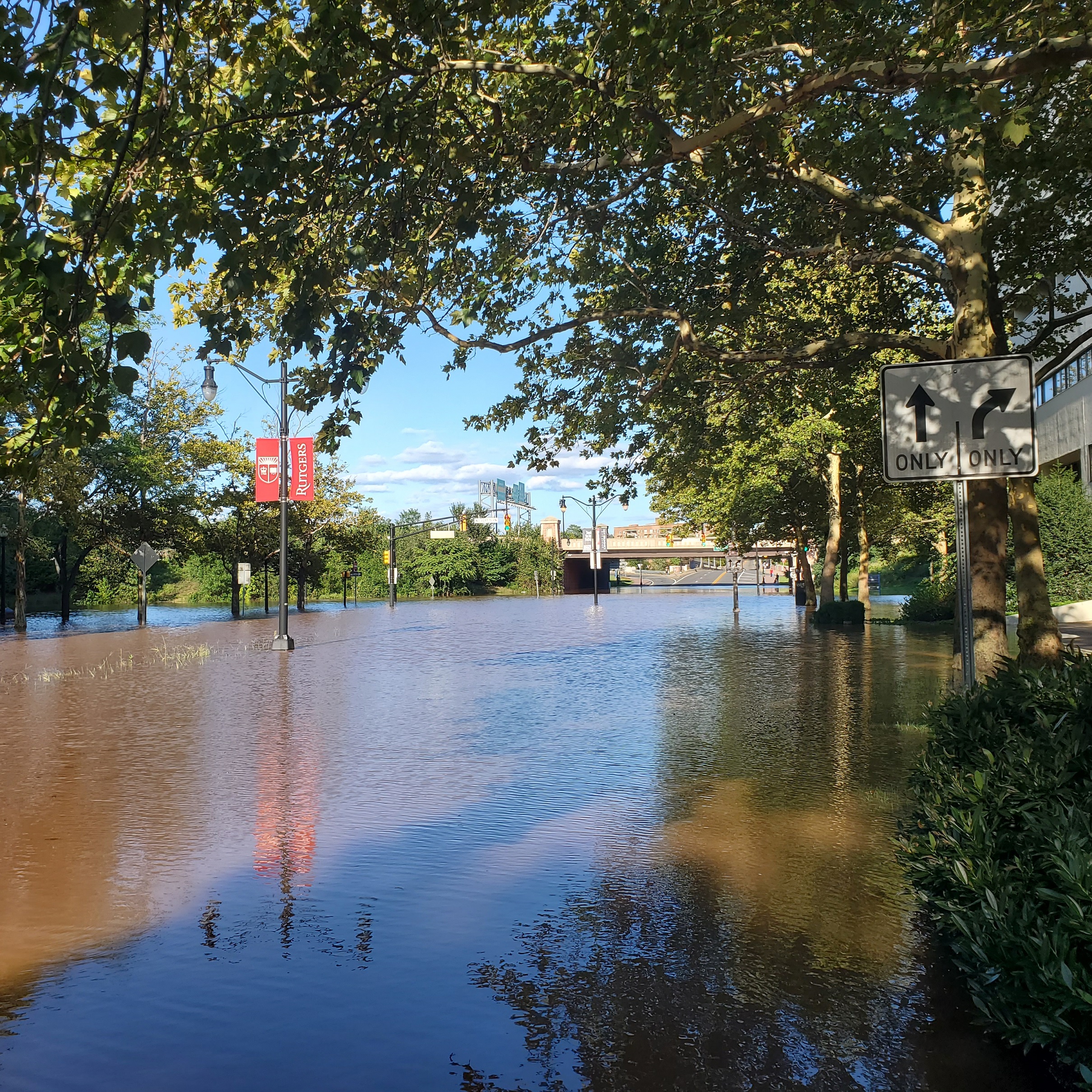
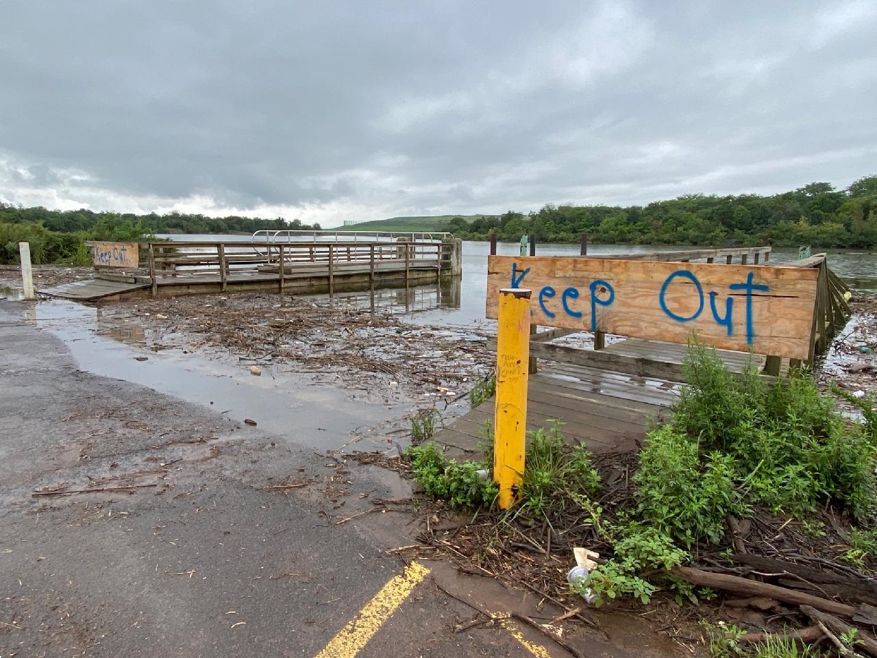
9.2.2021 Due to Hurricane Ida we were completely flooded in. No way in, no way out. Absolutely no way to access any of our sites. In fact, a few of them (at least the docks) may have floated away….
View from Albany Street (Route 27) looking toward Highland Park from New Brunswick. The Hyatt Hotel is on the right, Johnson & Johnson world headquarters on the left.
New Brunswick’s Raritan Landing.
9.9.2021 Raritan River pathogens count for all sites are in the “unsafe” range. In the wake of Hurricane Ida, we struggled to access several of our sites. Water is still high, the riverbanks are a trashy mess, and a few of our docks have floated away or been removed.
In the midst of a public health crisis and extreme weather events, green spaces offer both refuge and reflection. During the global pandemic, we’ve embraced parks and shared areas knowing that open air environments can better protect us from airborne viruses.
At the same time, climate change asks us to question the binary narrative of natural versus built environment. Despite our long term trend of fragmenting ecosystems with roads, pavements, and developments in an attempt to separate human spheres and natural spheres, our everyday systems demand a complete infringement of that binary when our trash ends up in rivers and our pollution affects all living beings.
And what about wildlife who find their homes sectioned off by bustling traffic or fish whose travel routes are disrupted by human made barriers and culverts? Watershed volunteers across New Jersey and New York have been using data tools to determine what habitat connectivity restoration could look like to create new passageways and mitigate disrupted ones.
And fortunately, local artists and scholars have been hard at work to tell the story of the past and future within our watershed. Their projects remind us that accessing the narrative of habitat connectivity is very possible when we interrogate our coexistence via art and local knowledge of our natural world. By encouraging meaningful outdoor experiences we can challenge dominant narratives that reduce our natural world to just “scenery” and “background”.
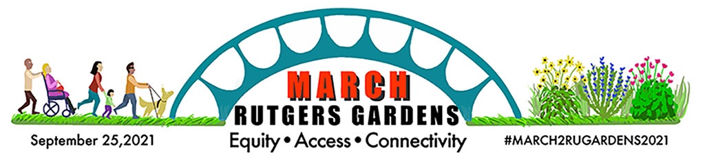
On September 25th, 2021 from 10 AM to 1 pm, community members will host a march from the Rutgers Cook/Douglass campus to the Rutgers Gardens. Yes, you heard that right! Locationally, Rutgers Gardens is isolated from being accessible to walkers and bikers as it requires travel via highway. The march will take unique routes to advocate for carbon neutral ways for us to reach the beautiful Gardens. As participants take this two mile walk they will be accompanied by incredible live performances of dance, music, and storytelling. Guests will learn from speakers about the history of the land that Rutgers was built on. To register for the event click here. And look out for the LRWP’s informational table at the end of the event!
#lookfortheriver FRAME in New Brunswick’s Boyd Park
The LRWP along with Colab Arts and Rubble R & D have completed our multi-year design and sculpture installation in New Brunswick’s Boyd Park. The FRAME sculpture aims to tell the story of the Raritan River over days, seasons, and years via a crowd-sourced photo database. The floodplain in Boyd Park suffers repeat flood inundation due to climate change and sea level rise. Through repeat digital photography we can understand possibilities for restoration and regeneration along our floodplains. We ask that park visitors participate as civic scientists by sharing their photos on Instagram using the hashtags #lookfortheriver and #lookfortheriverboydpark and tagging us @lookfortheriver.
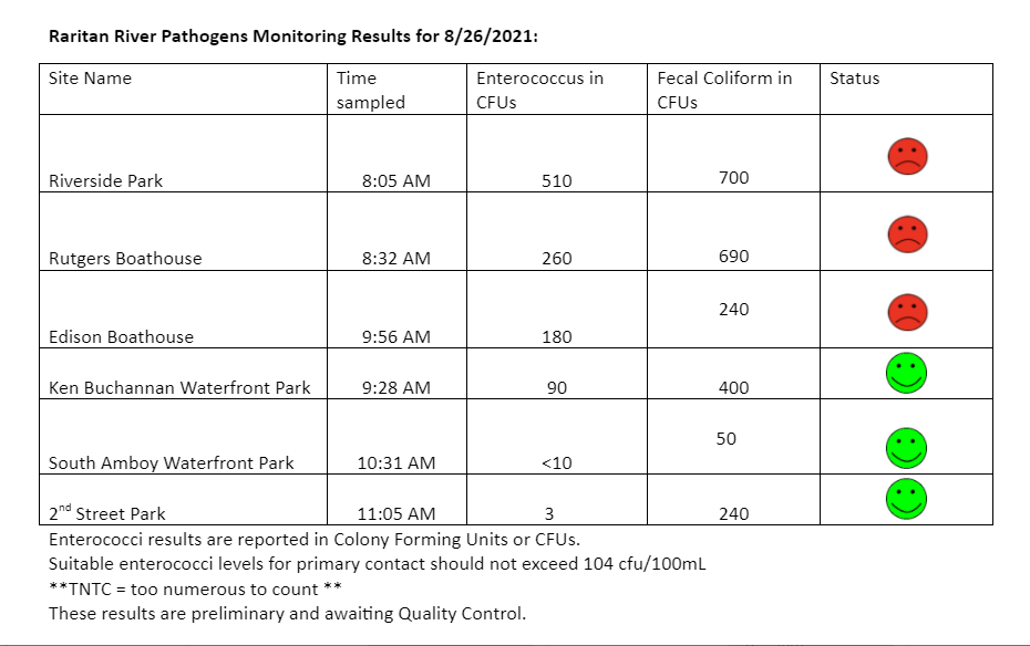
The Lower Raritan Watershed Partnership and Rutgers Cooperative Extension of Middlesex County run a volunteer pathogens monitoring program from May to September every Summer. On Thursdays we collect water quality samples at 6 non-bathing public access beaches along the Raritan River, and report out the results on Friday afternoons.
Monitoring results for yesterday 8.26.2021 show that our upstream sites (Piscatway, New Brunswick, Edison) are the ones with problems.
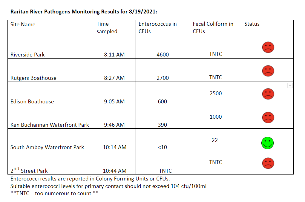
The Lower Raritan Watershed Partnership and Rutgers Cooperative Extension of Middlesex County run a volunteer pathogens monitoring program from May to September every Summer. On Thursdays we collect water quality samples at 6 non-bathing public access beaches along the Raritan River, and report out the results on Friday afternoons.
Our results for 8.19.2021 are just about the worst we’ve seen this year. According to our lab, the wonderful Interstate Environmental Commission, for several of our sites the enterococcus and fecal bacterial levels were “TNTC” or “Too Numerous To Count.” The South Amboy Waterfront Park site is the only “winner” for the week. It is relatively clean, likely due to tidal flushing.
The U.S. Department of Transportation’s Maritime Administration (MARAD) yesterday announced the designation of a new Marine Highway Project in the Lower Raritan as part of the America’s Marine Highway Program (AMHP), the Port Raritan Terminal Facility.
The “Marine Highway Project” designation will support service from the Raritan Port located in the Lower Raritan Watershed to various locations in New York City, accommodating Roll-on/Roll-off (Ro-Ro) barges carrying wheeled containers, ferries capable of carrying trucks, Lift-on/Lift-off (Lo-Lo) barges that can be used to support offshore wind-energy turbines, and other services.
According to the press release, project goals include:
create and sustain jobs in U.S. vessels, ports and shipyards
relieve landside congestion
reduce maintenance costs and improve the U.S. transportation system’s overall state-of-repair (wear and tear on roads and bridges)
drive the mandatory use of emerging engine technologies
improve U.S. economic competitiveness by adding new cost-effective freight and passenger transportation capacities
improve environmental sustainability of the U.S. transportation system by using less energy and reducing air emissions (such as greenhouse gases) per passenger or ton-mile of freight moved
improve public safety and security by providing alternatives for the movement of hazardous materials outside heavily populated areas
improve transportation system resiliency and redundancy by providing transportation alternatives during times of disaster or national emergency
improve national security by adding to the nation’s strategic sealift resources.
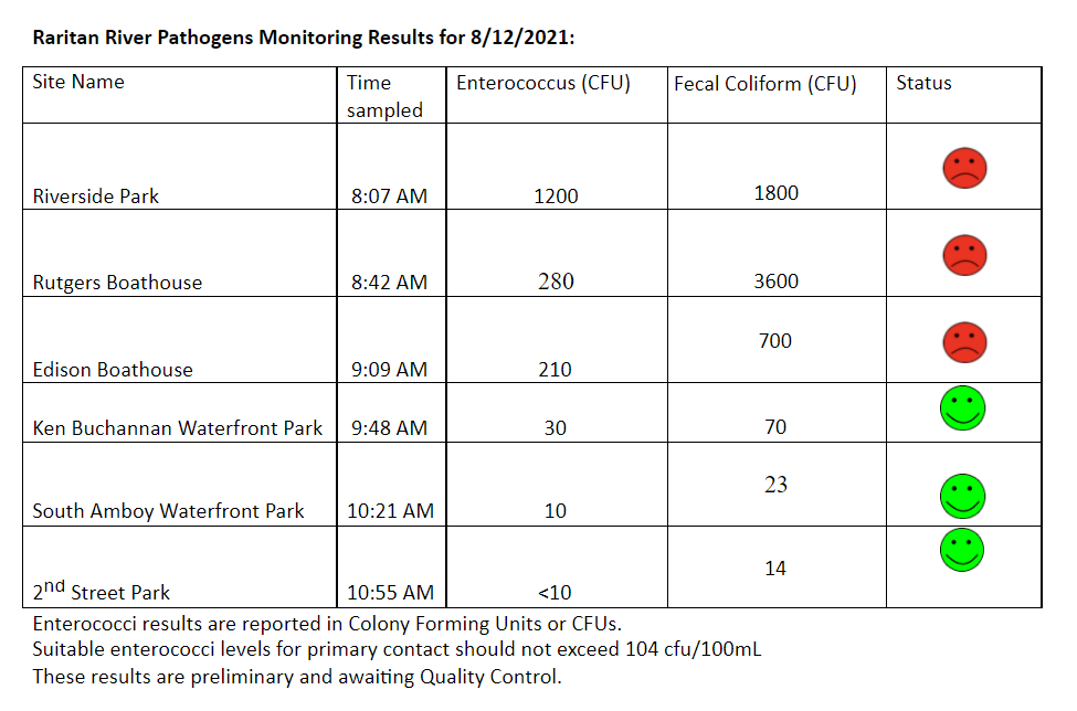
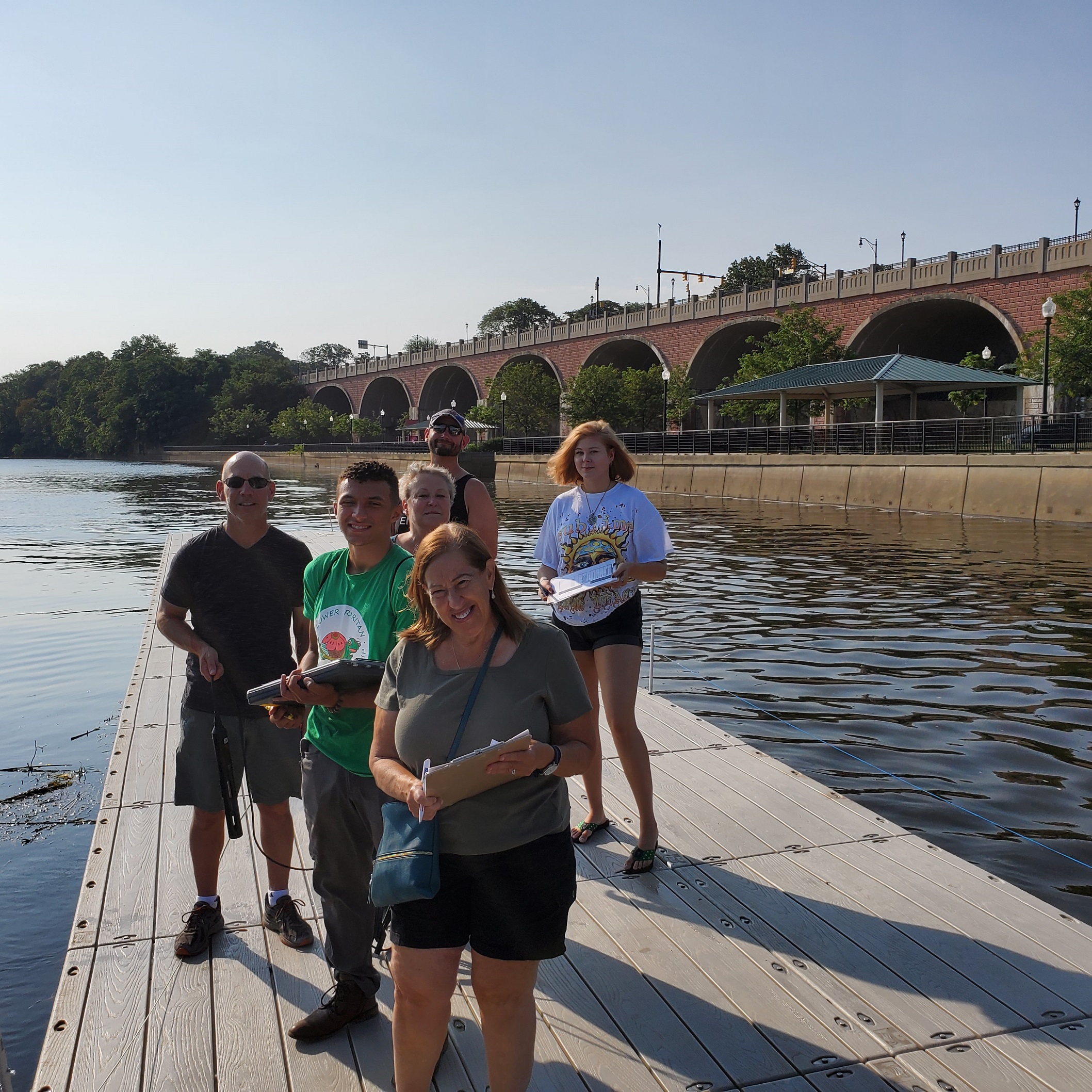
The Lower Raritan Watershed Partnership and Rutgers Cooperative Extension of Middlesex County run a volunteer pathogens monitoring program from May to September every Summer. On Thursdays we collect water quality samples at 6 non-bathing public access beaches along the Raritan River, and report out the results on Friday afternoons. Our results for 8.12.2021 are a mixed bag. Numbers for the upstream sites (Riverside Park, Rutgers Boathouse, and Edison Boathouse) are high, whereas downstream toward the Raritan Bay the numbers improve (Ken Buchanan Waterfront Park, South Amboy Waterfront Park, Perth Amboy’s 2nd Street Park). As always, if you choose to recreate on the water this weekend, stay safe, and be sure to wash your hands! See here for more information on our pathogens monitoring program.
A few additional things to share:
#1 Holy smokes was it a hot day for monitoring yesterday! If you are out in this crazy heat, stay hydrated!
#2: LRWP volunteers and friends are AMAZING!!
Gratitude to: Dorina Cardinale, Janet Sacklow, Jason Acevedo, Andrew Gehman and Maya Fenyk for sampling yesterday. And special thanks to Jesse Stratowski with Rutgers Recreation for opening things up at the boathouse for us!
Thanks also to LRWP Water Quality Outreach Project Coordinator Jocelyn Palomino and Rutgers Environmental Stewards Program Steward Julisa Collado (and her father Jose) for coordinating a fun youth outreach event at our last stop in Perth Amboy.
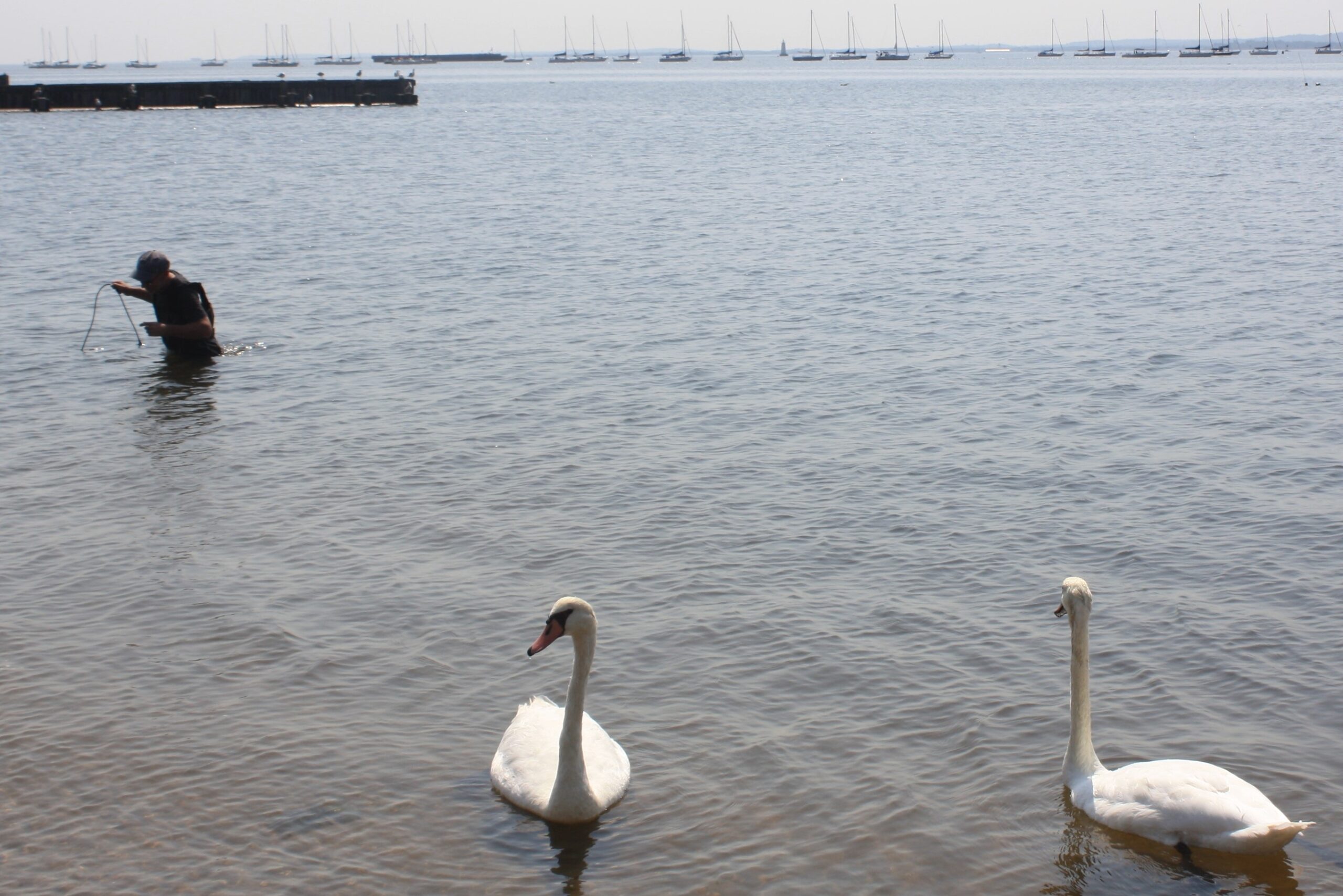
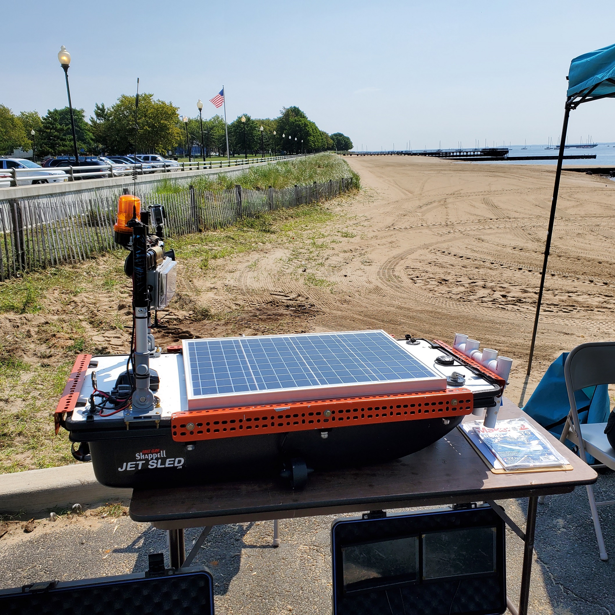
We enjoyed catching up with friends who joined us for outreach: a pair of white swans, Elizabeth Pyshnik with Rutgers Cooperative Extension Water Resources Program, Renee Skelton with Perth Amboy SWIM, Raritan Riverkeepers Bill Schultz & Lorraine McCartney, and Michael DuFour with Sky Horse Tech LLC who brought the very cool “water drone” prototype, designed for in-channel sampling (see photos).
We know that waters throughout the Raritan Basin contain unsafe levels of nutrients, fecal coliform and other pollutants – much of this type of polluting is directly related to “non-point source” pollution, most often stormwater runoff, which can be linked to land development and an excess of hard or “impervious” surfaces like roadways, asphalt parking lots, and buildings. Portions of our Lower Raritan Watershed also fail to meet federal Clean Water Act standards for phosphorous, pH, arsenic, chromium, mercury, copper, lead, temperature, dissolved oxygen, total dissolved solids and other pollutants. Some of this is due to historic “point source” dumping and legacy contaminants, and some of this is due to ongoing permitted point source polluting.
What is Permitted Point Source Polluting and who are New Jersey’s Permitted Polluters?
The New Jersey Pollution Discharge Elimination System (NJPDES) Program is designed to protect New Jersey’s ground and surface water quality by regulating treatment and discharge of polluted wastewater and stormwater from various types of facilities and activities. To accomplish this, the New Jersey Department of Environmental Protection (NJDEP) issues permits to polluting facilities limiting the mass and/or concentration of pollutants which may be discharged into ground water, streams, rivers, and the ocean. The types of regulated facilities can range from small users to large industrial and municipal wastewater dischargers. A complete list of the NJPDES permitted polluters for 2020 can be found here:
How can we protect our waterways from point source pollution?
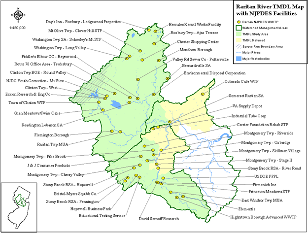
The NJDEP is required by the Clean Water Act to create and implement a plan to remove pollution from impaired water bodies. They do this by preparing a TMDL, or Total Maximum Daily Load determination for a water body. A TMDL is a scientific determination of the maximum amount of a given pollutant that a surface water body can absorb and still protect human health and aquatic life.
Unfortunately for the Lower Raritan, we do not have a TMDL. A TMDL to address pollution in the Raritan Basin was begun in 2016, but for our area – the Lower Raritan Watershed – it is incomplete. The white area in the map below shows swaths of land, and the NJPDES Facilities (permitted polluters) on that land that are not covered by a TMDL. Now this does not mean that polluters can pollute at will, but what it does mean is that we have less of a real sense for what pollutants are in our waters, or for what harm the mix of pollutants might cause.
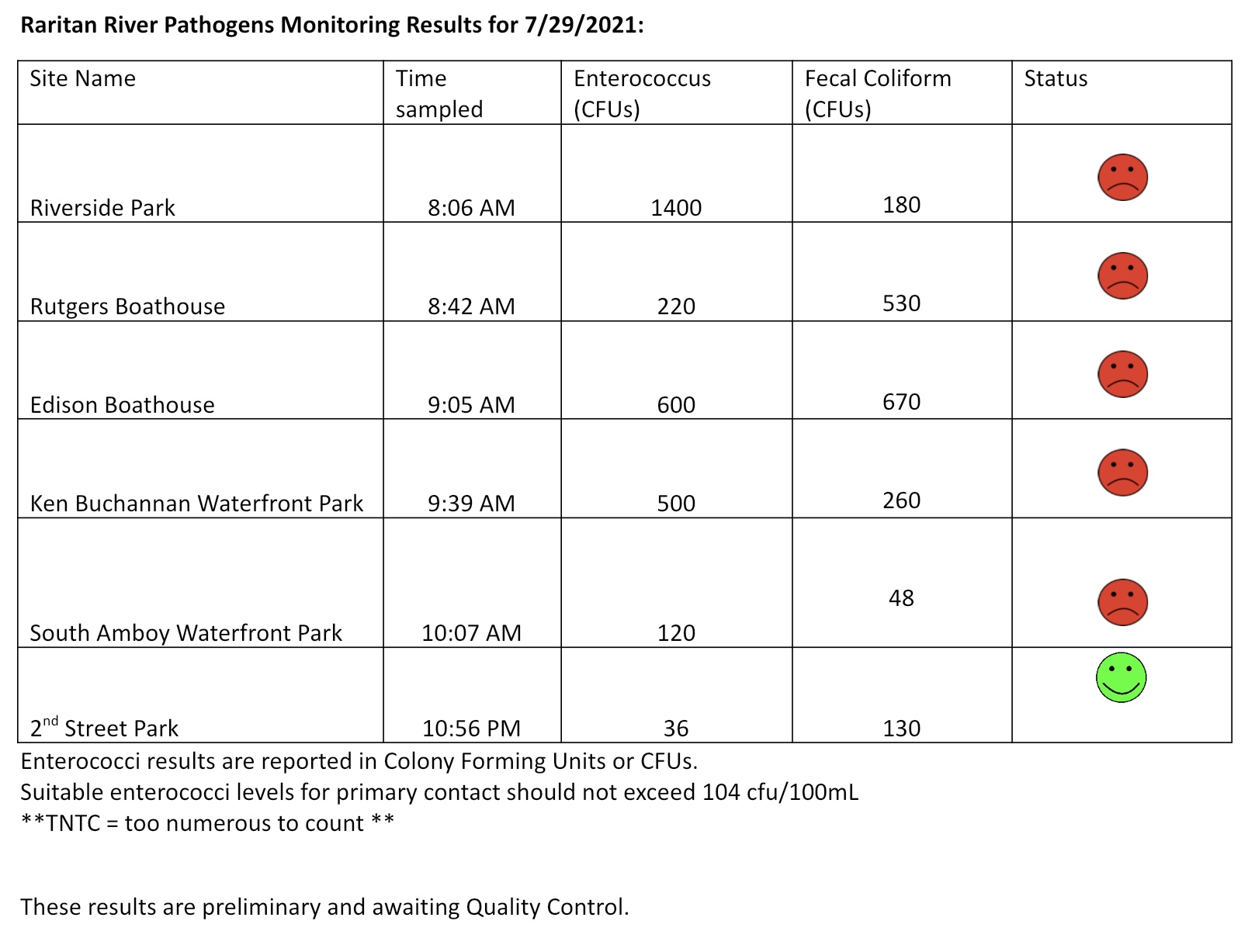
The Lower Raritan Watershed Partnership and Rutgers Cooperative Extension of Middlesex County run a volunteer pathogens monitoring program from May to September every Summer. On Thursdays we collect water quality samples at 6 non-bathing public access beaches along the Raritan River, and report out the results on Friday afternoons. Our results for 7.29.2021 are not so good. And the water samples were taken before over an inch of rain fell on the Lower Raritan, which almost always kicks up pathogens and bacteria. If you choose to recreate on the water this weekend, stay safe, and be sure to wash your hands! See here for more information on our pathogens monitoring program.
From its headwaters in the Devil’s Brook Swamp at Monmouth Junction, to its outlet on the Raritan, Lawrence Brook once powered six mills from Deans to New Brunswick. Over the next few months local historian Richard Walling will share his research (including photos and maps) into the history of the Lawrence Brook Mills sites and their relationship to our Raritan River and Lower Raritan Watershed.
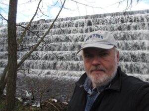
Richard is pictured here at the Farrington Lake step-dam, the site of a mill dating to the 1750s. He writes: “By the way, if the Brits had continued their 1778 withdrawal from Philly towards New Brunswick, what developed as the Battle of Monmouth could have taken place along the Lawrence Brook.“
This is the first in a series about mill sites along the Lawrence Brook.
Let us begin at the beginning: Geologically speaking, the Lawrence Brook generally separates two types of land forms in central NJ: the Piedmont & the Inner Coastal Plain. Brunswick shale is to the north of it, and loam to the south of it. The famed Middlesex County clay district extends westerly along the southern bank of the stream, at least as far west as Farrington Lake. Many of us remember digging gray clay from the shoreline near the broken dam in present-day Bicentennial Park (East Brunswick).
The Lenape called the stream, piskëpekw [-w is a whispered voiceless w], meaning “dark water”. Whether this alluded to the water’s color, to the shadowed waterway caused by steep banks, or even possibly from it’s headwaters at Devil’s Brook Swamp (did the Lenape call Devil’s Brook by the same connotation in their own language?). The land form of a neck, where Rutgers Village is located, was called ramawùnk (Ramawon in English), meaning “under the hill” or “under the bank”. Translations are provided by Lenape linguist, Ray Whritenour.
Native American artifacts are found all along the stream’s course and a path still runs along its eastern portion in the vicinity of Rte. 18 near the NJ Turnpike (Westons Mills). When a parking lot was being constructed on the Cook College campus, a cache of projectile points was found. The high ground at places like von Thun’s farm in South Brunswick, and Rutgers Gardens in New Brunswick once hosted villages. I know many folks who picked up artifacts in East Brunswick along Farrington Lake.
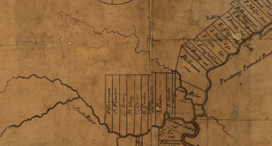
The earliest land transfer was from Native leaders to Thomas Lawrence, The Baker, a NY city merchant. As you can see from the circa 1685 map of the area, his holdings were affirmed by the East Jersey Board of Proprietors.
Map from 1685 showing the Lawrence Brook in relation to the Rariton (sic) River, South River, and land holdings of the time, source: https://www.loc.gov/item/97683564/
CONVEYANCE. Land called Ramawon on the south side of the Raritan River. [East Jersey].
Tract of land called Ramawon bounded by the Raritan and Pisscopeck Rivers.May 1, 1678
TO: Thomas Lawrence (Baker) (of New York; [Lawrence the Baker])
FROM: George Carteret (Sir) (Lord Proprietor); Philip Carteret (Esquire) (Governor of the Province)
PATENT. 1300 acres. South side Raritan River; a creek called PiscopeckIn 1693, the creek, now called Lawrence Creek (Brook), was granted to Peter Sonman, running from near Rocky Hill, all the way to Thomas Lawrence’s grant along the Raritan.
Oct. 20, 1693 TO: Peter Sonmans (Merchant) (of London; Proprietor; Son of Arent Sonmans, deceased, and Frances Sonmans; Brother of Johana Sonmans and Rachell Sonmans)
FROM: Proprietors of the Province of East New Jersey
CONVEYANCE. 38600 acres. Between Milston and Raritan Rivers; beginning at the Partition Line between East and West Jersey; opposite the foot of Rockie Hill; on both sides of Lawrence Creek; to the South River; Middlesex County.
June 7, 1677 Conveyance Record. NOTE: Isarick may have been the father of Wequeheela, who resided in present-day Spotswood.
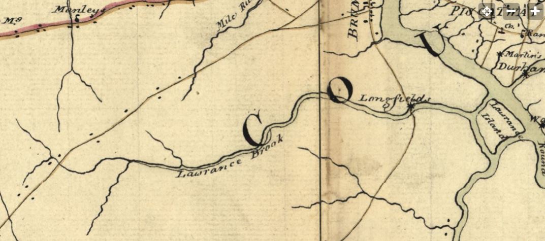
The 1781 map below, drawn by a British Army cartographer, is a general depiction of the stream, and of George’s Road (present-day Rte. 130 in part), George’s Road led from George Rescarrick’s Tavern (circa 1686) in Cranbury to New Brunswick. Below Cranbury, it led to Hightstown, Allentown, Crosswicks and points south. Longfield’s Mill is where Rte. 18 crosses the stream, a stretch known as Westons Mill.
Rich’s next installment will be on the Headwaters of the Lawrence Brook.
Since 2018 the LRWP has worked with Piscataway Township resident and Girl Scout Gabriella Robinson to increase awareness around water quality and actions individuals can take to improve the health of our local waters. Through this work Gabriella, a member of Troop 80877 and a rising senior, is completing the requirements for her Gold Award, Girl Scout’s highest honor. We are so grateful to Gabriella for her stewardship! See below for a summary of her work, in her own words, with a link to a video she developed for outreach. Thank you, Ella!
By Gabriella Robinson
Piscataway Girl Scout Gabriella Robinson
Go Green Central NJ is a water pollution prevention and awareness project!
I have been working on my project for about 2-3 years (2018 to present) and joined local cleanups, organized cleanups, and participated in discussions on environmental racism and how it connects to water pollution. I also created a video to increase the awareness of pollution of the Raritan River. I wanted people to know that every piece of garbage they pick up makes a difference in improving the water quality of the Raritan River and our community. Through these activities, I have learned more about what we can do to lower water pollution and bring awareness to others. I hope to continue helping others with my project to prevent water pollution!