By LRWP Monitoring Outreach Coordinator Jocelyn Palomino
During the summer, the Lower Raritan Watershed Partnership and Rutgers Cooperative Extension of Middlesex County run a volunteer-based monitoring program along the Raritan river that takes place every Thursday, from May to October. We collect water quality samples at SIX non-bathing public access beach sites, provide our samples to the Interstate Environmental Commission for analysis in their laboratory, and report the results to the public on Friday afternoons. Our mission is to share this data with the community and partners to ensure the safe use of the Raritan river for all.
After the rainfall experienced on Wednesday, our lab results for water quality samples taken on May 30, 2024 show Enterococcus bacteria levels exceeding the EPA federal water quality standard of 104 cfu/100mL at 4 of our monitoring sites this week. Problem sites are indicated by red frowns on the map and chart which include: Riverside Park (Piscataway), Rutgers Boathouse (New Brunswick), Edison Boat Basin (Edison) and 2nd Street Park (Perth Amboy). Green smiles on the chart and map indicate the sites with bacteria levels safe for recreation and include: Ken Buchanan Waterfront Park (Edison) and South Amboy Waterfront Park (South Amboy).
Pathogens/Enterococci levels are used as indicators of the possible presence of disease-causingbacteriain recreational waters. Such pathogens may pose health risks to people coming in primary contact with the water (touching) through recreational activities like fishing, kayaking or swimming in a water body. Possible sources of bacteria include Combined Sewer Overflows (CSOs), improperly functioning wastewater treatment plants, stormwater runoff, leaking septic systems, animal carcasses, and runoff from manure storage areas.
Our goal in reporting these results is to give residents a better understanding of the potential health risks related to primary contact during water-based recreation. If you decide to recreate on the Raritan this weekend, please do so safely and be sure to wash thoroughly after all activities!
We encounter all types of wildlife during monitoring, we always make sure to record data on which animals are present at the time of our sample collection, as it could possibly contribute to the fecal bacteria in the water. Photo Credit: Rose Lawless
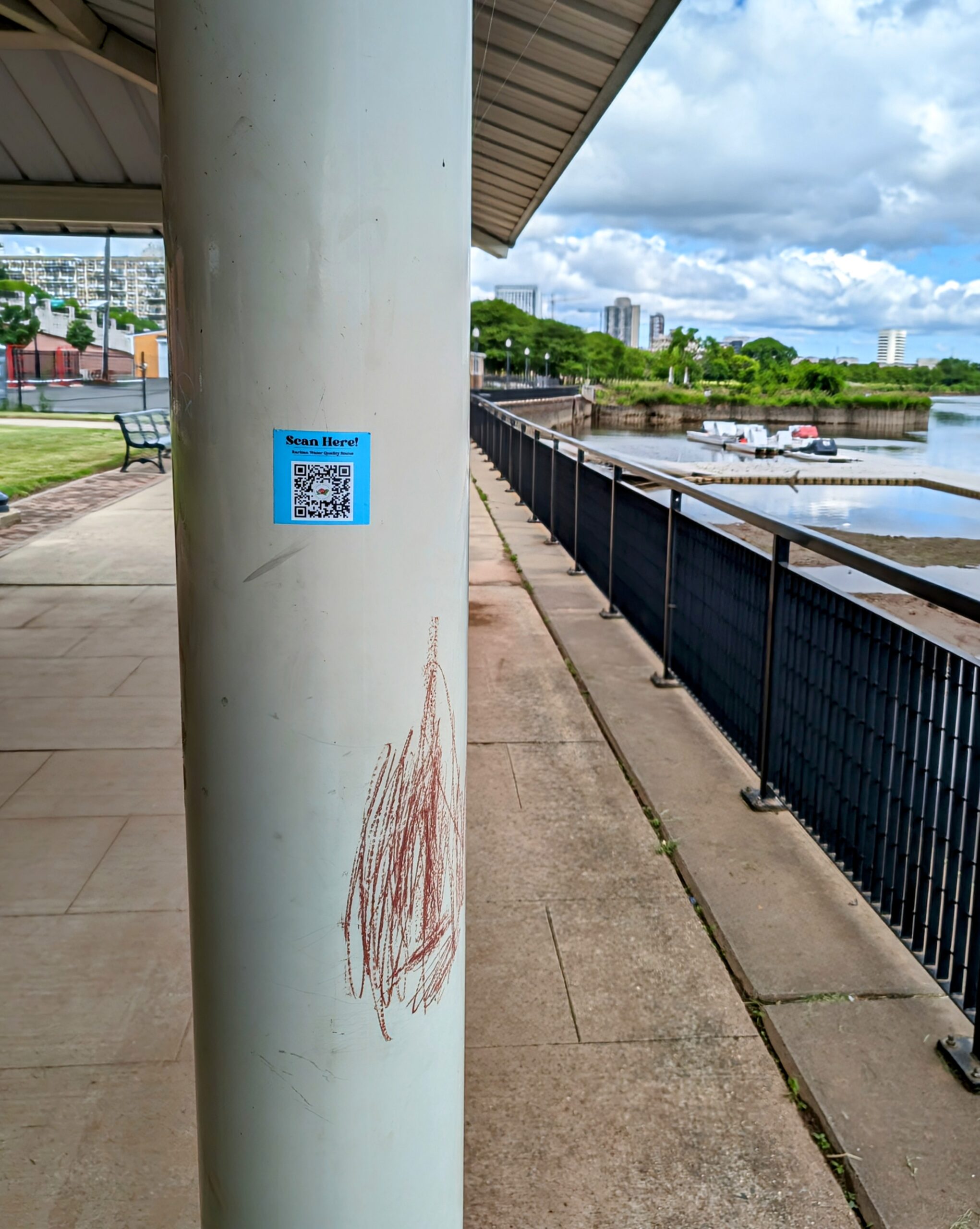
Don’t forget to keep an eye-out for our stickers with a QR code that directs you to the weekly water quality results on our website! Photo Credit: Rose Lawless
Volunteers Andrew Gehman and Rose Lawless working together to collect the data on this week’s water conditions at Ken Buchanan Waterfront Park, THANK YOU!! Photo Credit: Jocelyn Palomino
From collecting samples to conducting field observations, water quality monitoring takes teamwork to successfully gather the appropriate data to better understand what our results mean. Photo Credit: Jocelyn Palomino
Speaking of wildlife… we had a visitor lurking by at 2nd St. Park in Perth Amboy who was enjoying the sand! Photo Credit: Rose Lawless
By LRWP Monitoring Outreach Coordinator Jocelyn Palomino
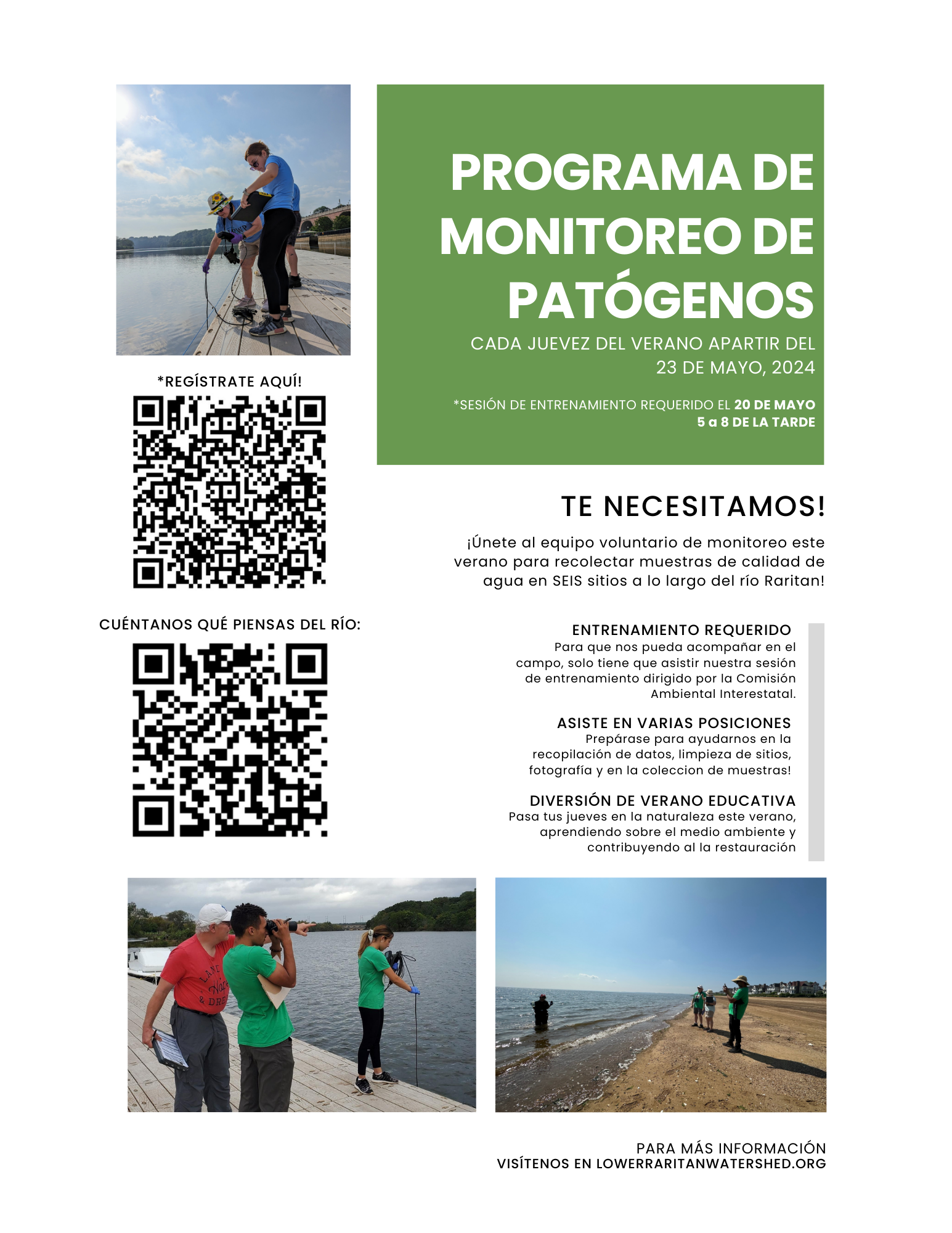
On Thursday May 23, the Lower Raritan Watershed Partnership and Rutgers Cooperative Extension of Middlesex County kicked-off the 2024 Summer Pathogens Monitoring Program! This volunteer-based program runs from May to October and takes place every Thursday monitoring along the Raritan River. We collect water quality samples at SIX non-bathing public access beach sites, provide our samples to the Interstate Environmental Commission for analysis in their laboratory, and report the results to the public on Friday afternoons. We are looking forward to sharing our data with the community and partners to ensure the safe use of the Raritan river for all.
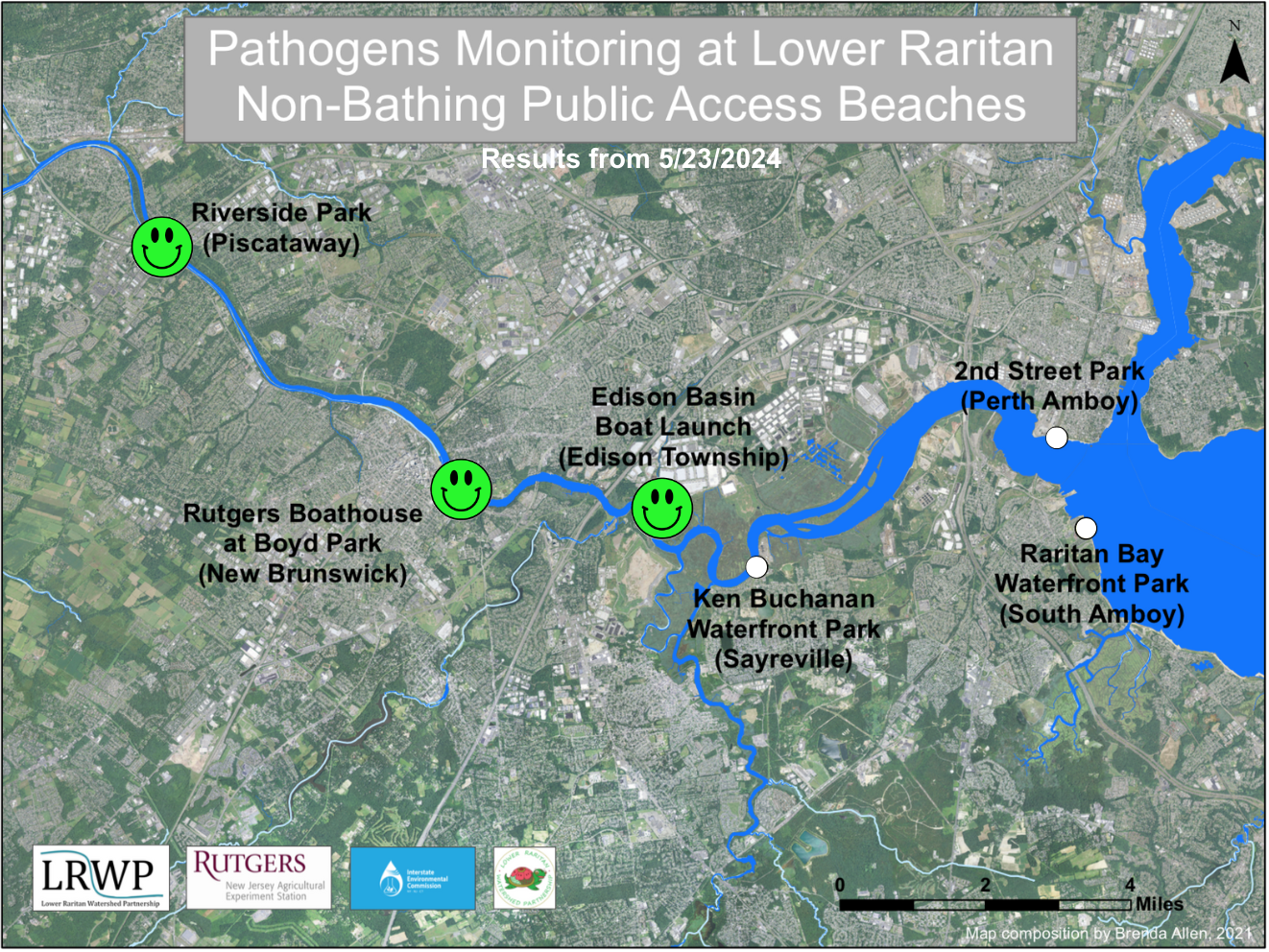
Unfortunately, the beginning of our 2024 season was cut short due to heavy rains and lightning, and we only collected 3 of 6 samples during our first run. Lab results for water quality samples taken on May 23, 2023 show that Enterococcus bacteria levels do not exceed the EPA federal water quality standard at the three upstream sites we collected at this week. Green smiles on the chart and map indicate sites with bacteria levels below the standard safe for recreation which only includes three sites this week: Riverside Park (Piscataway), Rutgers Boathouse (New Brunswick) and Edison Boat Ramp (Edison).
Please note that two of our samples were taken prior to the rain event (Riverside Park and Rutgers Boathouse), and keep in mind that the Raritan River receives significant stormwater runoff during rain events, often contributing to pollutant loading in our waterways.
Pathogens/Enterococci levels are used as indicators of the possible presence of disease-causingbacteriain recreational waters. Such pathogens may pose health risks to people coming in primary contact with the water (touching) through recreational activities like fishing, kayaking or swimming in a water body. Possible sources of bacteria include Combined Sewer Overflows (CSOs), improperly functioning wastewater treatment plants, stormwater runoff, leaking septic systems, animal carcasses, and runoff from manure storage areas.
Our goal in reporting these results is to give residents a better understanding of the potential health risks related to primary contact during water-based recreation. If you decide to recreate on the Raritan this Memorial Day Weekend, please do so safely and be sure to wash thoroughly after all activities!
BIG thanks to Sofi Grossman and Frank Dahl, our first volunteers of 2024! Thanks also to Interstate Environmental Commission Intern Ruby Alcorn and IEC Environmental Analyst Samantha Wilder for coming out to help kick things off! Photo credit: Maya Fenyk
Our team collecting samples and data as the rainfall started early Thursday morning. The rain couldn’t stop us, but lightning could! Photo credit: Heather Fenyk
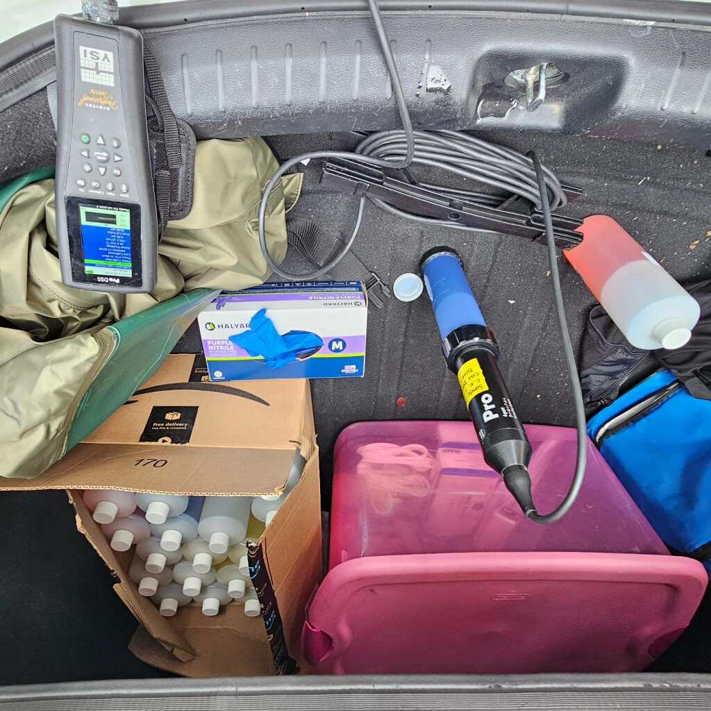
Our Quality Assurance Protocol Plan (QAPP) requires us to conduct pre and post-calibration of the monitoring equipment to ensure that our YSI is reading parameters, like pH and salinity, as accurately as possible. We use Project Coordinator Jocelyn Palomino’s car trunk as a makeshift lab. Photo credit: Heather Fenyk
Article by LRWP Volunteer Monitoring Irene Riegner
“Water, water everywhere”—but can you drink it? For the last five years, citizen scientists under the guidance of the Lower Raritan Watershed Partnership have been monitoring the water quality of the lower Raritan River. Last summer, I was one of those monitors. Once a week from late spring through early fall, through spring rains and summer heat, we tested the waters from Perth Amboy north to Piscataway. We tested quantitatively through water samples and instrument readings and qualitatively through observation. The river was in better condition than I would have imagined: Despite abandoned factories along its banks; despite surrounding industrial neighborhoods, junk yards, and heavy industry; despite the usual litter; despite sewage outflow; despite bird guano.
Near Highland Park, I watched a great blue heron gracefully stalking its prey. Then, zap. The fish entered its eternal afterlife. In Piscataway, cormorants floated on the river and periodically dived for dinner. Near the Edison Boat Basin, osprey, scrutinizing the river from their high perch, nested across from a landfill and next to a petro-chemical factory. The river must be alive; there must be a plentiful source of food in its depths.
Water quality monitoring volunteer, and article author, Irene Riegner helps the LRWP and NJDEP scout locations installation of an ISCO water quality sampler for a Summer 2024 study
We took readings for dissolved oxygen, pH and salinity and measured the temperature. The numbers varied but usually landed within favorable parameters, pointing to a reasonably healthy aquatic life. On the other hand, elevated readings of enterococcus, an indicator of pathogenic disease, were troublesome. We took water samples for testing. A red face on our charts indicated that enterococcus was above the permitted level. Perhaps effluvia from a nearby outflow. Perhaps runoff after a rainstorm. Perhaps downstream waste flowing upstream with the current.
“Do you eat the fish you catch?” I asked the local fishermen casting their lines into the water. “We throw ‘em back,” most of them answered. Fishing and the river mean a morning with their buddies. Sailing and the river mean recreation with family and friends. The sailboats are moored in the river near South Amboy, near the million dollar, Victorian style homes, snuggled between factories and dumps. I never observed anyone swimming from the sand beach in front of these homes.
Last summer, I began learning about the river, learning to understand it as an organism with complex parts, both natural and human-constructed, whose reach radiates beyond its banks into the municipalities and parks that line its shores—and beyond. Maybe with the communal effort of municipalities lining the Raritan and its tributaries, the river once again can become a focal point for recreation—and maybe, someday, we could even eat the fish and swim in it.
The 2023 summer monitoring revealed the cleanest water yet.
In March the LRWP brought on Jeff Key as a part time business manager. We are so pleased to have him on board! Jeff has an extensive background in law and leadership. A former Americorps Teaching Fellow, Assistant Professor at Seton Hall Law, and now Founder/Principal Consultant with NFinityEnterprises, Jeff’s focus is on supporting New Jersey based nonprofits in their aims to provide equitable access to services and programming. Jeff currently serves on the board of the Center for NonProfits and the National Board of the Young Nonprofit Professionals Network. Spring 2024 Intern Maxim Pavon sat down with Jeff to learn more about him and his work, we share the interview below.
Welcome Jeff! We are happy to have you on board with the LRWP, and would love for our community to get to know a little more about you and your work:
What’s your favorite outdoor spot in the Lower Raritan?
I enjoy spending time at Boyd Park, which was built when I was growing up in the area and has been expanded over the years. I’m always a big fan and advocate of maintaining and creating green spaces in cities as gathering spaces, a way to have sustainable development, and important spaces for residents to have accessible space for outdoor activities and recreation. The Delaware and Raritan Canal State Park is a close second spot with amazing trails to explore and I’ve been excited to see the expansion of projects like the East Coast Greenway to connect different trail systems through multiple states.
With an extensive background in law and leadership, what has interested you so much in the realm of virtual communications as to found Nfinity Enterprises, a web design and technology consulting firm devoted to the success of small businesses and nonprofits?
I started working with nonprofits immediately after graduating law school at a time when social media and website presence was a growing trend, and some of my responsibilities that developed over time involved working in these areas. Meeting so many people working at amazing nonprofits let me know that they were making an amazing impact that was being overlooked in some cases, and with up to date websites and systems to show impact and tell their story they could connect with more donors and volunteers to get the support they deserve. Technology is advancing so rapidly that I think it’s crucial that nonprofits working on some of the most important social challenges have access to these tools for positive impact and also have a voice in advocating how these advances affect the communities they work in.
What is the most common struggle you see among small and mid-size nonprofit organizations?
With small and mid-size nonprofit organizations, there is a challenge around scaling programming for growth and effectively using staff capacity. I definitely see technology playing a role in helping with that, since one of the most valuable resources for nonprofits is staff time and capacity and efficient systems, automation, and time-saving processes free up staff members to focus more on critical day-to-day work and strategic planning.
How do you see your work assisting the LRWP to address such hurdles?
I see my work with LRWP helping to build out systems and processes to make it easier for folks at every level to engage with the organization or complete their work: volunteers, staff, and donors/supporters. A second area that I hope to assist LRWP is thinking about how to build systems that will work for current programming and operations, but also be ready to scale to meet needs as the organization grows and adds additional staff, programming, and events.
I think my connections have put me in contact with an amazing network of professionals working at nonprofits that are very different from the organizations that I’ve had personal experience working at. That opportunity to share with and learn from ideas and approaches that have been successful at other organizations has been amazing, and is one of the things that I appreciate about working in the nonprofit sector. It did take me some time to recognize the importance of networking on a wider scale outside of the immediate area where you work, so I try to encourage students, interns, and younger nonprofit professionals to do that as soon as possible in their careers.
Finally, what is one mantra that you live by?
One mantra that I live by is that all failure is an opportunity to learn, grow, and engage in self-reflection. As someone who definitely tends to be a perfectionist, this is something that I’ve had to learn as I’ve progressed in my career and be intentional about remembering. With many of the skills and abilities that I now consider myself to be good at, there was definitely an initial learning curve and instances where something I tried or was in charge of did not meet expectations. Anyone who ends up being really good at anything or considered an amazing expert absolutely made mistakes along the way and didn’t let those setbacks stop them from continuing to work and improve their craft.
The changing climate and development patterns of the Lower Raritan Watershed occur against a backdrop of substantial impervious surface coverage (approximately 34%), high population density, and significantly modified stream networks (e.g., stream straightening and burial, culverts, underground retention). Through hundreds of years of anthropogenic influence, the historic stream channels have been altered or “disappeared,” resulting in increased flooding, compromised water quality, and decreases in aquatic and other species. The added influence of climate change heightens these impacts. In addition, many Lower Raritan Watershed municipalities have no way to understand the lost natural and cultural heritage represented by the historic hydrology, the failing underground infrastructure and the collapse of buried streams.
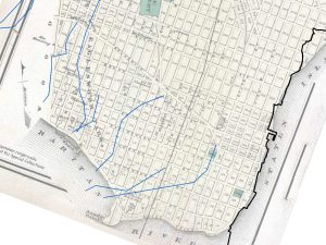
Figure 1. An 1872 map of Perth Amboy overlaid with linework (in blue) showing potential streams from other map sources.
The research is intended to develop a systematic approach to define, identify, and describe the progression of the geographic pattern of “hidden” and “dynamic” streams in the Lower Raritan Watershed — that is, those areas that no longer exhibit all of their surface stream channels due to the effects of human development and population growth. It will allow for creation of an organized system for relevant stream and hydrology maps and map downloads to assist in “finding” the lost and hidden waterways in our watershed. This research is important as a way to understand our historic ecology and also to inform efforts that seek to use stream daylighting as a form of Green Infrastructure for stormwater management, water infrastructure management, and water quality improvements in our urban communities. Sharing the resulting data and materials will represent a first step towards the creation of a comprehensive data clearinghouse for the communities of this landscape.
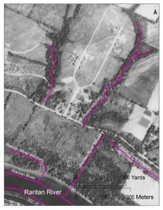
Figure 2. This early 1930s black and white aerial photography of Piscataway shows the early development of Ross Hall Blvd and parts of what is now the Rutgers Ecopreserve. The fuscia linework shows the current NHD stream dataset that was used for comparison in the project.
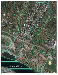
Figure 3. A recent color photo of the same area in Piscataway overlain with the GIS-generated linework (in green) showing terrain-based analysis of potential drainage and stream patterns.
This project captures the Raritan River’s lost heritage by creating new data while making existing records more widely available and used. This ongoing research endeavors to define, identify, and describe the progression of the geographic pattern of “hidden” and “forgotten” streams in the Lower Raritan Watershed — that is, those areas that no longer exhibit all of their surface stream channels due to the effects of human development and population growth. This research helps us understand our historic ecology and also can inform future efforts that seek to use stream daylighting as a form of Green Infrastructure for stormwater management, water infrastructure management, and water quality improvements in our urban communities.
Initial outcomes included:
Created a research catalog linking to 40 sites with potential materials for ongoing evaluation and inclusion
Evaluated materials at 22 of those sites
Catalogued 230 maps to evaluate
Developed 41 sharable georectified version of historic maps
Identified over 2000 line segments on the historic maps that do not closely match those in the contemporary stream data
The GeoHealth Lab at the CRSSA and the LRWP intend to supplement the ongoing project with volunteers while seeking additional funding in order to continue, (a) acquiring, compiling, and georectifying historic maps, (b) expanding and improving the project website, and (c) field check sites to determine the streams’ status.
Please note: the boat shop will be closed on Saturday May 18. We will be back at work on Wednesday May 22, 6-8pm. As always, please pre-register for our programs to receive notice of any cancellations or changes to programming.


