By Kate Douthat, third year PhD candidate in the graduate program of Ecology and Evolution at Rutgers. Kate’s research is examining the plant communities that have formed in urban stormwater systems. She is interested in the extensive stormwater infrastructure network in New Jersey and how we can use plants to improve water quality. Kate loves to share her enthusiasm about plants and to teach the public about the stormwater systems in our backyards. She has agreed to develop a series of informative blogs for the LRWP’s readers and will also lead our #booksfortheriver book club starting Fall 2019. You can see more of her writing about plants and water resources at katedouthatecology.com
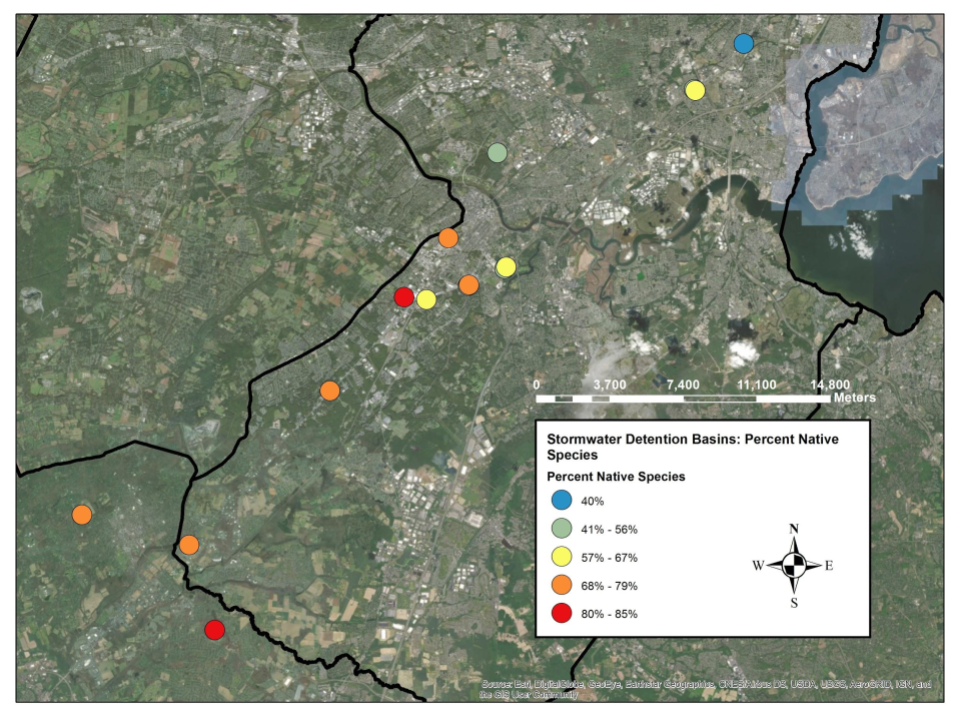
This map shows the location of each site and the percent native species in each basin. The map shows a trend for lower percentage native species at more northern sites, so location matters!
During the summer of 2018, I surveyed plants in stormwater detention basins throughout an urban and suburban area of central New Jersey. This study is aimed at improving water quality and wetland habitat by choosing the right plants for the job. Selecting appropriate sites for renovations and the choosing the best species to plant depends on many factors. Two important factors are the plants’ ability to survive in basin conditions and the natural tendency for certain plants to colonize basins regardless of what we plant there. One question I am addressing is how survival and colonization change depending on the surrounding landscape. Because catch basins at various locations receive different amounts of pollution and seeds, I expect to see different plants in different settings.
How does the surrounding landscape influence the plant community in a stormwater detention basin?
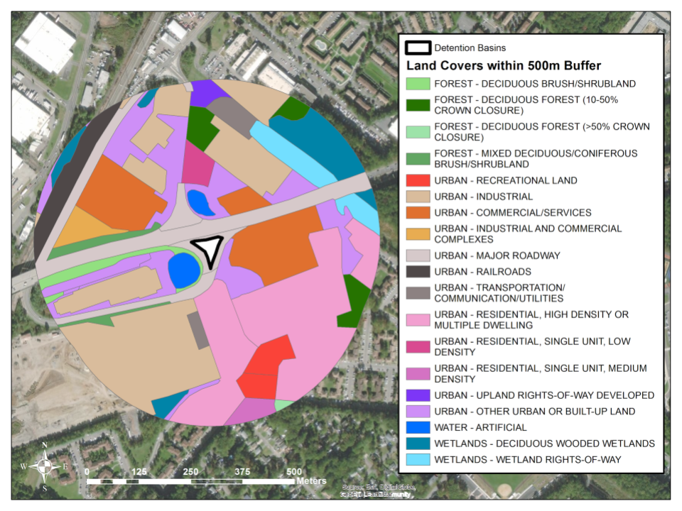
The adjacent land use and land cover influence wetland properties, including plant communities. Land cover is the type of stuff on the site, such as forest or roads. Land use is the activity that humans do on the site. Both factors affect plant communities. The surrounding landscape influences the plant community by the quantity and type of seeds available and by dispersal routes. One of the basic ways that plant communities are quantified is by the number of different species on a site, termed “species richness.” Paved roads around a wetland affect plant species richness and roads are particularly important dispersal routes for invasive plants. The proportion of native plants increases with forest cover in the surrounding area.
In this analysis, I am using the land use and land cover within 500 meters of each catch basin to explore relationships between adjacent land and the proportion of native species in the basin. I used a computer program to do exploratory regression. That technique takes each possible explanatory factor and tests the strength of the relationship between that factor and the factor of interest. In this case, the factors are land cover types and the percent native species at a site. I found that more adjacent commercial and service area leads to a lower percentage of native species in a catch basin. Transportation and utility areas, such as power line right-of-ways, also contributes to a lower percentage of native species. On the other hand, the percent of native species increases when a basin is surrounded by recreation area and wooded wetlands.
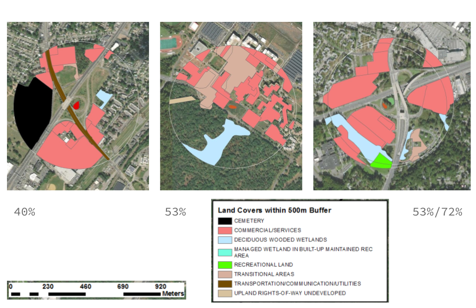
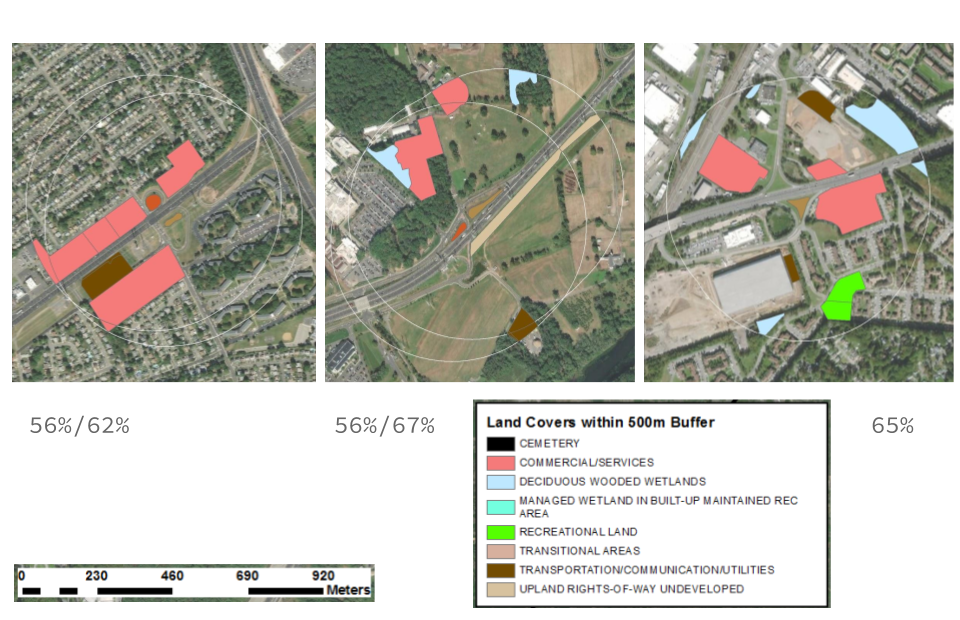
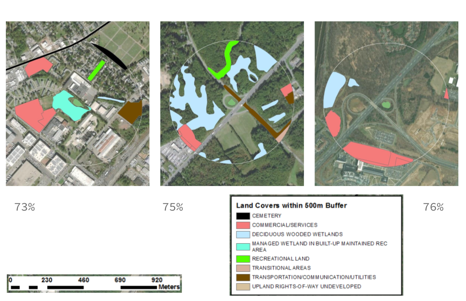
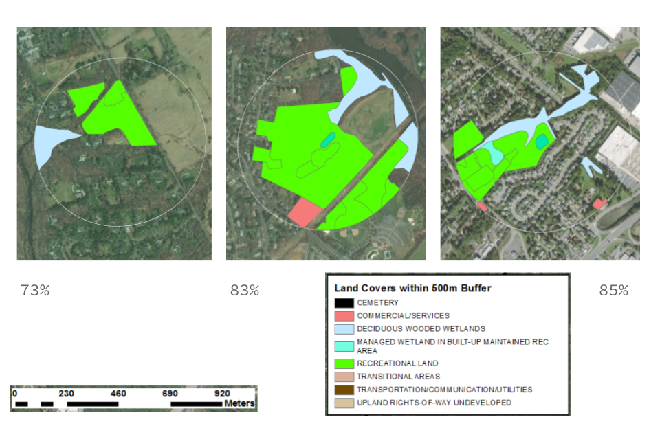
The following series of maps shows the areas around each catch basin. The maps are arranged from lowest percent native species to highest. In some cases there were two basins next two each other, so there are two numbers shown for the percent native species in each one individually. The land cover types with the strongest relationship to percent native species are colored. The reds and pinks are commercial or transitional areas, the light blues are wetlands, and the green is recreation area. (The names in the legends are the specific technical terms.)
The maps show that the amount of commercial or recreation area that surrounds a catch basin makes a big difference to the plants that live there. This result can help land managers decide which restoration goals are appropriate in different settings. For example, by the roadside, where there are more non-native species, a basin may be redesigned to filter pollution. Non-native species can perform this service as well as native species. However, in a park or recreation setting, where there are relatively more native species, a catch basin may be restored to include rare and sensitive native species. This analysis still needs fine tuning, but shows promise as a way to predict plant community characteristics based on the surrounding landscape.
Article by Billy Kurzenberger, Program Coordinator at City of Perth Amboy, Office of Economic and Community Development
The City of Perth Amboy, in partnership with the Rutgers Cooperative Extension Water Resources Program and with funding provided by the New Jersey Department of Environmental Protection (NJDEP), has launched several new projects in its community-based green infrastructure initiative, Perth Amboy SWIM (Stormwater Infrastructure Management).
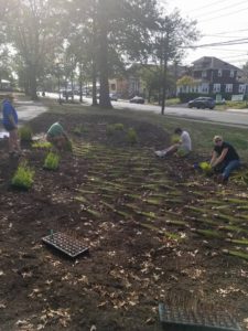
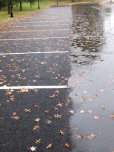
Washington Park is the site of a new rain garden designed to redirect and absorb rainwater while beautifying the park. The park’s parking lot is now resurfaced in porous pavement designed to allow rain water to pass through the surface and seep into the ground instead of running off into our stormwater sewers.
In addition to the projects at Washington Park, the same partnership is responsible for the installation of two other porous pavement parking lots at municipal parking lot C on Jefferson Street and municipal parking lot RDH on Madison Street. All of these efforts will help us protect our local waterways from nonpoint source pollution, reduce flooding around the City and serve as excellent educational tools for the community.
A Perth Amboy SWIM porous/pervious pavement Green Infrastructure project at Washington Park. October 9/2017 was the first rain. Rain water is allowed to pass through the asphalt & soak into the soil rather than flood the neighborhood. Photo Credit: Raritan Riverkeeper.
Perth Amboy SWIM meets on the third Thursday of every month at 10am and always welcomes new members! Meetings are held in the Brighton Avenue Community Center (56 Brighton Avenue, Perth Amboy, NJ). For more information, please contact Billy Kurzenberger at wkurzenberger@perthamboynj.org
Our April 17 meeting will focus on stormwater management, and will include a discussion of regional approaches to stormwater management.
The agenda will include an overview of federal expectations with respect to MS4 requirements, with Matt Klewin (NJDEP) presenting on “Update on Changes in the New MS4 Revision”. Manville Borough Administrator Andrea Bierwirth will speak about challenges to meeting MS4 requirements in the upper portion of the watershed.
The meeting will be held from 10-noon in the Middlesex County Planning Offices at 75 Bayard Street, New Brunswick, NJ – 5th floor mid-size conference room.
Parking is validated for those parking on floors 5 and higher in the RWJ Wellness Parking Deck located at 95 Paterson Street, New Brunswick, NJ 08901. Be sure to bring your ticket to the meeting for validation.
For more information contact Heather: hfenyk AT lowerraritanwatershed DOT org
EPA Kicks Off Fifth Annual Campus RainWorks Challenge
College students compete to design green infrastructure for their campus
The U.S. Environmental Protection Agency (EPA) just launched its fifth annual Campus RainWorks Challenge, a competition for college and university students to design innovative solutions for our nation’s water infrastructure. Using their campuses as labs, teams develop green infrastructure systems to reduce stormwater pollution and build resilience to climate change. Since 2012, more than 420 student teams have participated in the challenge.
“Stormwater is one of the nation’s most significant water challenges, with increasing amounts of runoff polluting our nation’s streams, rivers and lakes,” said Joel Beauvais, Deputy Assistant Administrator for EPA’s Office of Water. “Through the Campus RainWorks Challenge, EPA invites our country’s future planners, designers, and engineers to apply their classroom learning and help us solve stormwater management problems through innovative green infrastructure design and technology.”
Teams may register for the 2016 Challenge from September 1st to September 30th. The 2016 Challenge winners will be announced in spring 2017. Each first-place team will earn a student prize of $2,000 and a faculty prize of $3,000 to support green infrastructure research or training. Second-place teams will win $1,000 for student teams and $2,000 for faculty research.
Green infrastructure decreases pollution to local waterways by treating stormwater where it falls and keeping more polluted runoff out of sewer systems. Green infrastructure features include green roofs, permeable materials, green streets, rain gardens and rain harvesting systems. Communities are increasingly using green infrastructure to supplement their “gray” infrastructure such as pipes, filters and ponds.
Green infrastructure can create vibrant communities by increasing economic activity, neighborhood revitalization, job creation and open space. It also strengthens a community’s resiliency to the impacts of climate change by reducing the burden on local water infrastructure, managing local flooding, reducing urban heat islands and lowering energy demands.
We would love to see some of the schools in the Lower Raritan Watershed enter this competition!
More information is available at www.epa.gov/campusrainworks
The LRWP September 20 general meeting will be in the CDM Smith Edison offices where CDM Smith will provide a live overview of the NYC GreenHUB tool.
CDM Smith is working with the NYC DEP Office of Green Infrastructure to develop a Project Tracking and Asset Management System capable of compiling, mapping and reporting data from thousands of GI installations throughout their service life. This integrated system, named NYC GreenHUB, presents a user-friendly, multi-function interface that enables comprehensive data management and access control. NYC GreenHUB is a web-based system that automates the procedures used by OGI to collect, review, manage and report information. DEP utilizes its asset maintenance feature to manage and monitor maintenance activities such as repairs, replacement, pruning and replanting. The system provides geospatial visualization of GI assets with easy access to data throughout the asset lifecycle – from asset initiation, siting, design, and construction through operations and maintenance.
AGENDA
9:30 am Welcome and introductions, Heather Fenyk (LRWP)
9:35 am Green Infrastructure (GI) in the New Jersey context, Kandyce Perry (JerseyWaterWorks GI sub-committee)
9:40 am Introduction of speakers, Maria Watt (CDM Smith)
9:45 am Overview of Green Infrastructure, Maria Watt (CDM Smith)
9:50 AM What is Asset Management and NYC GreenHUB Live Demo, Jayson Brennen (CDM Smith)
10:10 Philadelphia Green City Clean Water, William Cesanek (CDM Smith)
10:25 am Camden Asset Management, Andrew Kricun (Camden County Municipal Utilities Authority)
10:35 am Benefits of Asset Management, David Zimmer (New Jersey Environmental Infrastructure Trust)
10:45 am Q & A, Group Discussion
11:00 am Next steps for JerseyWaterWorks and the LRWP
The CDM Smith presentation is an outgrowth of the LRWP’s work with the JerseyWaterWorks Green Infrastructure sub-committee.
CDM SMith is located at: 110 Fieldcrest Avenue, #8, 6th Floor| Edison, NJ 08837