Running for 20 weeks through Summer 2021, the Lower Raritan Watershed Partnership and Rutgers Cooperative Extension of Middlesex County (RCE) will gather data and other information on water quality for public access sites along the tidal portions of the Raritan River at locations considered non-bathing beaches. This project is supported through grants from the Interstate Environmental Commission (IEC) and The Watershed Institute.
Summer 2021 Pathogens/Bacteria Monitoring Sites
LRWP and RCE will monitor non-bathing beach sites with active kayak/canoe launches and/or fishing and other primary contact activities that, as non-bathing beach sites, are not regularly monitored by the New Jersey Department of Environmental Protection (NJDEP) or the New Jersey Department of Health and Human Services and lack sufficient water quality data.
In addition to yielding important data about the health and safety of our waterways, the Project will also allow for development of civic science and expanded volunteer environmental monitoring programming within the Lower Raritan Watershed and Middlesex County, NJ. We are working with an approved Quality Assurance Project Plan (QAPP), provided by the IEC, which will allow for data generated from this project to inform water quality policy and regulatory decisions at all levels of government within the project area, and to educate the public about the safety of recreating on the River.
Real-time reporting of enteroccocus data will be posted every Friday on the LRWP facebook page and website, and through the New York City Water Trail Association’s citizen’s water quality testing program. Users will be able to easily interpret the data as being above or below the recommended water quality standards for primary contact recreation.
Enterococci levels are used as indicators of the possible presence of disease-causing bacteria in recreational waters. Such pathogens may pose health risks to people fishing and swimming in a water body. Sources of bacteria include Combined Sewer Overflows (CSOs), improperly functioning wastewater treatment plants, stormwater runoff, leaking septic systems, animal carcasses, and runoff from manure storage areas. Enterococci results are reported in Colony Forming Units or CFUs. Suitable levels should not exceed 104 cfu/100mL.
The following are details on our monitoring sites. We will share more information about each location throughout the monitoring period. For more information about the program please contact: info@lowerraritanwatershed.org
LR1
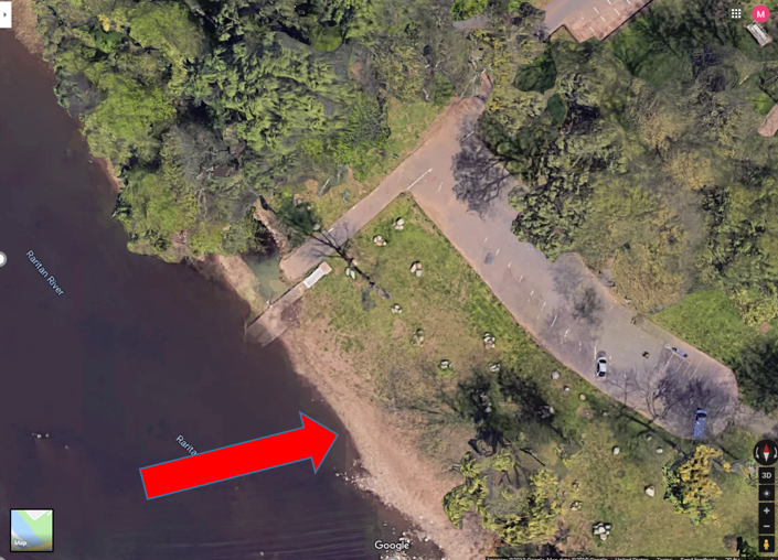
Riverside Park, 430 River Rd, Piscataway
40.54067
-74.51219
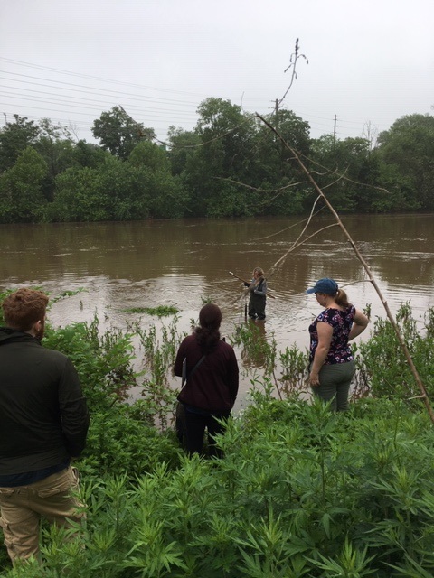
Wading site. Waders must be worn. Red arrow indicates the sampling location as this is where fishing has been observed. Access the river to the left of the boat ramp (when facing the river). Do not take the sample from the boat ramp as it is too muddy and slippery.
Bathrooms are available at this site from 10am to 2pm
LR2
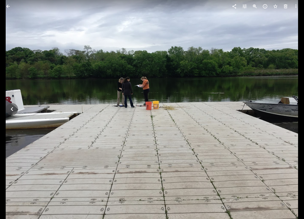
Rutgers Boathouse, 5 Memorial Pkwy, New Brunswick
40.48826
-74.43384
Sampling location is in the middle of the Rutgers boathouse dock as indicated in picture. Bathrooms may be available at the boathouse if they are open and at Boyd Park just west of the boathouse.
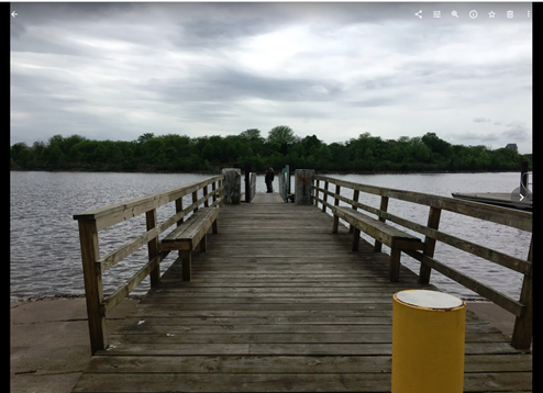
Sampling
location is at the end of the dock. No bathrooms are available at this site.
LR4
Ken Buchanan Riverfront Park River Road, Sayreville, NJ 08872
40.47483
-74.35586
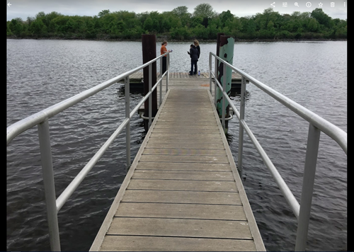
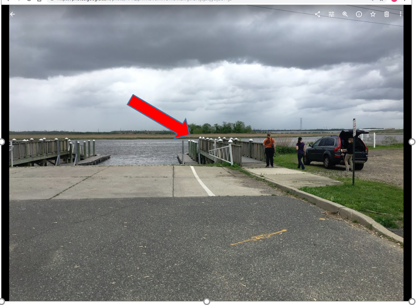
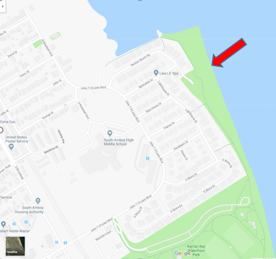
LR5
Raritan Bay Waterfront Park 201 John T O’Leary Blvd South Amboy, NJ 08879 *sample off Raritan Reach Road north of park
40.48334
-74.2698
Wading site and waders must be worn. Access the sampling location off the parking lot at the end of Raritan Reach Rd. This is northwest of the park. The site is a beach. No bathrooms available.
LR6
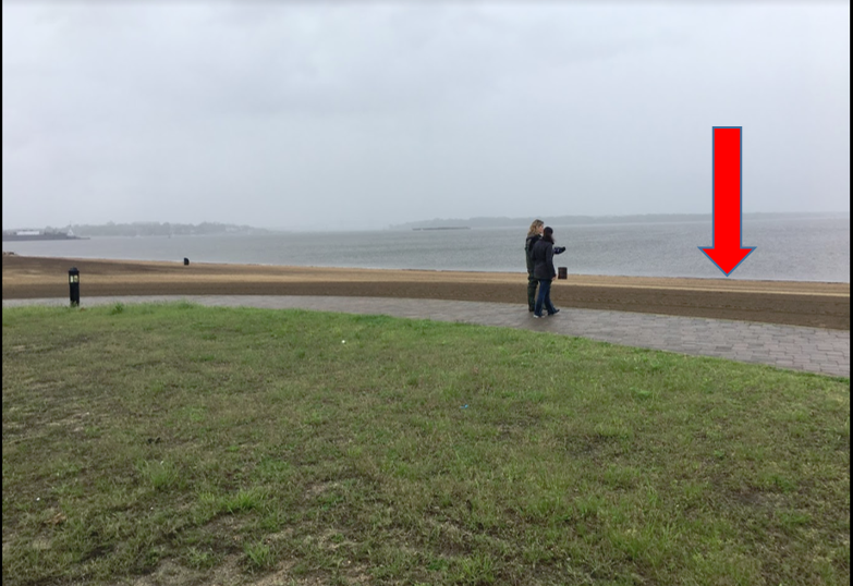
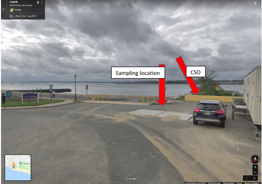
Perth Amboy Waterfront & Future 2nd Street Park 45-93 2nd St, Perth Amboy, NJ 08861
40.50007
-74.27719
This is a wading site and waders must be worn. Sampling location is at the beach next to the combined sewer outfall pipe. No bathrooms are available.
Running for approximately 15 weeks through Summer 2020, the Lower Raritan Watershed Partnership and Rutgers Cooperative Extension of Middlesex County (RCE) will gather data and other information on water quality for public access sites along the tidal portions of the Raritan River at locations considered non-bathing beaches. This project is supported through grants from the Interstate Environmental Commission (IEC).
Summer 2019 Pathogens/Bacteria Monitoring Sites
LRWP and RCE will monitor non-bathing beach sites with active kayak/canoe launches and/or fishing and other primary contact activities that, as non-bathing beach sites, are not regularly monitored by the New Jersey Department of Environmental Protection (NJDEP) or the New Jersey Department of Health and Human Services and lack sufficient water quality data.
In addition to yielding important data about the health and safety of our waterways, the Project will also allow for development of civic science and expanded volunteer environmental monitoring programming within the Lower Raritan Watershed and Middlesex County, NJ. We are working with an approved Quality Assurance Project Plan (QAPP), provided by the IEC, which will allow for data generated from this project to inform water quality policy and regulatory decisions at all levels of government within the project area, and to educate the public about the safety of recreating on the River.
Real-time reporting of enteroccocus data will be posted every Friday on the LRWP facebook page and website, and through the New York City Water Trail Association’s citizen’s water quality testing program. Users will be able to easily interpret the data as being above or below the recommended water quality standards for primary contact recreation.
Enterococci levels are used as indicators of the possible presence of disease-causing bacteria in recreational waters. Such pathogens may pose health risks to people fishing and swimming in a water body. Sources of bacteria include Combined Sewer Overflows (CSOs), improperly functioning wastewater treatment plants, stormwater runoff, leaking septic systems, animal carcasses, and runoff from manure storage areas. Enterococci results are reported in Colony Forming Units or CFUs. Suitable levels should not exceed 104 cfu/100mL.
The following are details on our monitoring sites. We will share more information about each location throughout the monitoring period. For more information about the program please contact: info@lowerraritanwatershed.org
LR1
Riverside Park, 430 River Rd, Piscataway
40.54067
-74.51219
Wading site. Waders must be worn. Red arrow indicates the sampling location as this is where fishing has been observed. Access the river to the left of the boat ramp (when facing the river). Do not take the sample from the boat ramp as it is too muddy and slippery.
Bathrooms are available at this site from 10am to 2pm
LR2
Rutgers Boathouse, 5 Memorial Pkwy, New Brunswick
40.48826
-74.43384
Sampling location is in the middle of the Rutgers boathouse dock as indicated in picture. Bathrooms may be available at the boathouse if they are open and at Boyd Park just west of the boathouse.
Sampling
location is at the end of the dock. No bathrooms are available at this site.
LR4
Ken Buchanan Riverfront Park River Road, Sayreville, NJ 08872
40.47483
-74.35586
LR5
Raritan Bay Waterfront Park 201 John T O’Leary Blvd South Amboy, NJ 08879 *sample off Raritan Reach Road north of park
40.48334
-74.2698
Wading site and waders must be worn. Access the sampling location off the parking lot at the end of Raritan Reach Rd. This is northwest of the park. The site is a beach. No bathrooms available.
LR6
Perth Amboy Waterfront & Future 2nd Street Park 45-93 2nd St, Perth Amboy, NJ 08861
40.50007
-74.27719
This is a wading site and waders must be worn. Sampling location is at the beach next to the combined sewer outfall pipe. No bathrooms are available.
Our team conducted pathogens (enterococci) monitoring of six Raritan River public access sites a bit early this week so as to report out in time for the holiday weekend. We are very happy to report that with a few exceptions (Piscatway and Perth Amboy), our numbers look pretty good!
Enterococci results are reported in Colony Forming Units or CFUs. Suitable levels should not exceed 104 cfu/100mL.
The Lower Raritan Watershed Partnership is grateful to our
EARTH Center of Middlesex County partners, to the Interstate Environmental
Commission for lab analysis, to the Sustainable Raritan River Initiative for
providing grant support, to Jesse Stratowski and his team at the Rutgers
Boathouse, and of course to our wonderful volunteers!
**Please note: these results are preliminary and awaiting Quality Control**
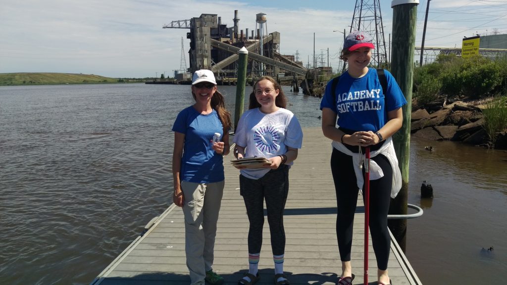
Many thanks to our great team of volunteers who dedicated their Thursday to sampling for fecal coliform and enterococci at six non-swimming beach public access sites along the Raritan River.
Enterococci levels are used as indicators of the possible presence of disease-causing bacteria in recreational waters. Such pathogens may pose health risks to people fishing and swimming in a water body. Sources of bacteria include Combined Sewer Overflows (CSOs), improperly functioning wastewater treatment plants, stormwater runoff, leaking septic systems, animal carcasses, and runoff from manure storage areas. Enterococci levels are often high after heavy or consistent rainfall.
Enterococci results are reported in Colony Forming Units or CFUs. Enterococci results are reported in Colony Forming Units or CFUs. Suitable levels should not exceed 104 cfu/100mL.
Site Name
Time
Enterococcus (CFU)
Riverside Park (40.54067, -74.51219)
9:51
TNTC
Rutgers Boathouse (40.48826, -74.43384)
10:32
TNTC
Edison Boathouse (40.48769, -74.38409)
11:09
TNTC
Ken Buchannan Waterfront Park(40.47483, -74.35586)
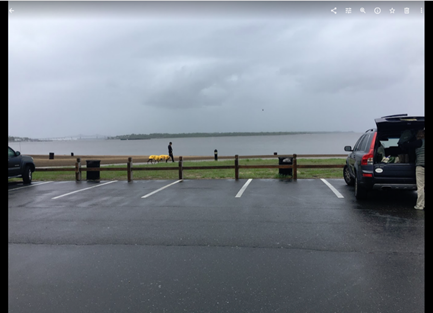
Monitoring at Riverside Park in Piscataway 5.30.2019. Photo by Jim Hearty
Please note that while we follow quality control measures, the real-time nature of data delivery means that EPA has not reviewed, and these are not technically quality controlled.
Running for 20 weeks through Summer 2019, the Lower Raritan Watershed Partnership and Rutgers Cooperative Extension of Middlesex County (RCE) will gather data and other information on water quality for public access sites along the tidal portions of the Raritan River at locations considered non-bathing beaches. This project is supported through grants from the Interstate Environmental Commission (IEC) and Rutgers’ Sustainable Raritan River Initiative (SRRI).
Summer 2019 Pathogens/Bacteria Monitoring Sites
LRWP and RCE will monitor non-bathing beach sites with active kayak/canoe launches and/or fishing and other primary contact activities that, as non-bathing beach sites, are not regularly monitored by the New Jersey Department of Environmental Protection (NJDEP) or the New Jersey Department of Health and Human Services and lack sufficient water quality data.
In addition to yielding important data about the health and safety of our waterways, the Project will also allow for development of civic science and expanded volunteer environmental monitoring programming within the Lower Raritan Watershed and Middlesex County, NJ. We are working with an approved Quality Assurance Project Plan (QAPP), provided by the IEC, which will allow for data generated from this project to inform water quality policy and regulatory decisions at all levels of government within the project area, and to educate the public about the safety of recreating on the River.
Real-time reporting of enteroccocus data will be posted every Friday on the LRWP facebook page and website, and through the New York City Water Trail Association’s citizen’s water quality testing program. Users will be able to easily interpret the data as being above or below the recommended water quality standards for primary contact recreation.
Enterococci levels are used as indicators of the possible presence of disease-causing bacteria in recreational waters. Such pathogens may pose health risks to people fishing and swimming in a water body. Sources of bacteria include Combined Sewer Overflows (CSOs), improperly functioning wastewater treatment plants, stormwater runoff, leaking septic systems, animal carcasses, and runoff from manure storage areas. Enterococci results are reported in Colony Forming Units or CFUs. Suitable levels should not exceed 104 cfu/100mL.
The following are details on our monitoring sites. We will share more information about each location throughout the monitoring period. For more information about the program please contact: info@lowerraritanwatershed.org
LR1
Riverside Park, 430 River Rd, Piscataway
40.54067
-74.51219
Wading site. Waders must be worn. Red arrow indicates the sampling location as this is where fishing has been observed. Access the river to the left of the boat ramp (when facing the river). Do not take the sample from the boat ramp as it is too muddy and slippery.
Bathrooms are available at this site from 10am to 2pm
LR2
Rutgers Boathouse, 5 Memorial Pkwy, New Brunswick
40.48826
-74.43384
Sampling location is in the middle of the Rutgers boathouse dock as indicated in picture. Bathrooms may be available at the boathouse if they are open and at Boyd Park just west of the boathouse.
Sampling
location is at the end of the dock. No bathrooms are available at this site.
LR4
Ken Buchanan Riverfront Park River Road, Sayreville, NJ 08872
40.47483
-74.35586
LR5
Raritan Bay Waterfront Park 201 John T O’Leary Blvd South Amboy, NJ 08879 *sample off Raritan Reach Road north of park
40.48334
-74.2698
Wading site and waders must be worn. Access the sampling location off the parking lot at the end of Raritan Reach Rd. This is northwest of the park. The site is a beach. No bathrooms available.
LR6
Perth Amboy Waterfront & Future 2nd Street Park 45-93 2nd St, Perth Amboy, NJ 08861
40.50007
-74.27719
This is a wading site and waders must be worn. Sampling location is at the beach next to the combined sewer outfall pipe. No bathrooms are available.
The Lower Raritan Watershed Partnership and Rutgers Cooperative Extension of Middlesex County seek civic science volunteers to assist with the Summer 2019 “Citizen Science Monitoring for Pathogens Indicators on the Raritan River.” This program will run every Thursday from May 23 to September 26. Volunteers will travel with a monitoring team to capture water quality samples at sites along the Raritan River, followed by a trip to the NEIWPCC lab in Staten Island to assist with preparation of samples for analysis. A 2 hour training is required, after which the Project Team would like volunteers to commit to assisting with at least five (5) sampling events throughout Summer 2019.
The first training will be on Thursday May 9, 1-3:30 PM at the EARTH Center of Middlesex County. Registration required.
This project will allow us to gather data and other information on water quality for six public access sites along the tidal portions of the Raritan River at locations considered non-bathing beaches. In addition to capturing water samples at each of the six public access sites, volunteers will have the opportunity to go to the NEIWPCC’s lab on Staten Island to learn how samples are processed for monitoring.
We will monitor non-bathing beach sites with active kayak/canoe launches and/or fishing and other primary contact activities that are not regularly monitored by the New Jersey Department of Environmental Protection or the New Jersey Department of Health and Human Services and lack sufficient water quality data.
Bacteria data will be reported in “real-time” on Friday afternoons to allow Lower Raritan residents and others to make informed decisions about their on-water recreation activities for the weekend.
The Project will also allow for development of civic science and expanded volunteer environmental monitoring programming within the Lower Raritan Watershed and Middlesex County, NJ. Working with an approved Quality Assurance Project Plan (QAPP) will allow for data generated from this project to inform water quality policy and regulatory decisions at all levels of government (state, federal, local) within the project area, and to educate the public.
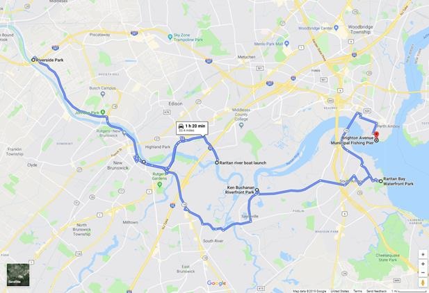
Water quality monitoring sampling will directly inform public access decision-making for six (6) diverse Lower Raritan Watershed municipalities (see site map below). These sites include:
Riverside Park (Piscataway)
Rutgers Boathouse at Boyd Park (New Brunswick)
Edison Basin Boat Launch (Edison Township)
Ken Buchanan Riverfront Park (Sayreville)
Raritan Bay Waterfront Park (South Amboy)
2nd Street / Brighton Avenue Beach (Perth Amboy)
Sites were chosen to inform decision-making about access and use, to aid understanding of municipal stormwater and sewage flows, and to inform current and future landuse planning and restoration efforts. Sites include the following known activities: 1) launch sites for personal non-motorized watercraft (sites 1-5); 2) fishing (sites 2-6); 3) birding hotspots (site 5); 4) crabbing (sites 2,4,5,6); 5) proximate to Combined Sewer Overflow (site 6); 6) unofficial bathing activity (sites 2,5,6); 7) collegiate watersport competition (site 2).
Generous support for equipment and data analysis is provided by the New England Interstate Water Pollution Control Commission.