Article and Photos by Michele Bakacs
Ahoy There Matey! Rutgers Environmental Stewards Take Their First Boat Trip on the Raritan River
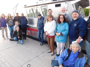
On May 3rd the Middlesex class of Rutgers Environmental Stewards took the water. This afforded them a rare opportunity to see the Raritan River up close by taking a 2 hour boat trip on the new R/V Rutgers. The R/V Rutgers is a new boat operated by the Department of Marine and Coastal Sciences. This 36 ft. (11 meter) aluminum landing craft is a 20 passenger vessel and supports a wide range of educational and scientific needs such as trawling, grab sampling, diving, water profiling, coring, AUV operations, etc. Faculty can reserve the vessel so students can get a first-hand look at the Raritan River ecosystem and the human impacts to the watershed.
This is part of a larger effort by the Rutgers Collaborative for Research and Education to “Bring the River to your classroom” and works to support faculty efforts in engaging students and the community in Raritan River data and science through data activities.
The Rutgers Environmental Stewards program trains volunteers on important environmental issues affecting New Jersey and helps them make a difference in their own communities. The program consists of 60 hours of classes offered around the state on topics including habitat protection, climate change, geology, soil health, alternative energy, invasive plants, environmental policy, pollinators, and much more. Stewards complete a 60 hour internship of their choosing in order to become certified. Optional field trips are included. Anyone can become an Environmental Steward regardless of background.
The Stewards met the boat in Boyd Park in New Brunswick at the Class of 1914 Boathouse and were welcomed by the boat’s captain Chip Haldeman, and first mate Nicole Waite. Joining us on our trip was Dr. Heather Fenyk, Director of the Lower Raritan Watershed Partnership, and Dr. JeanMarie Hartman, Professor in the Department of Landscape Architecture. Heather and JeanMarie provided a rich history of the Raritan and identified points of interest including shale outcrop geologic formations, the Lenape Trail connection to the River, noted flora and fauna, as well as the industrial legacy of contaminated sites, old factories, and the Edgewater Landfill.
First mate Nicole taught the Stewards how researchers monitor water quality and trained them on collecting data using YSI water monitoring probes to test for dissolved oxygen, pH, temperature, and salinity. We also saw 2 Bald Eagles, countless Ospreys, Cormorants, and vast marshland. The salt marshes are mostly dominated by Phragmites australis, an invasive grass known as Common Reed, but we also saw native Spartina alterniflora (Salt Marsh Cordgrass) holding its own at the fringes of the saltmarshes.
Overwhelmingly the Stewards walked away with a new appreciation of this fantastic natural resource that most of us take for granted. Most people see the Raritan River as a place to avoid, to view from afar from the Garden State Parkway or Route 1 Bridge. This experience helped the Stewards better understand the River that lies in the heart of their community, and the importance of making sure it is cleaned up and protected.
Keep an eye on the LRWP blog for information about how to register for the Rutgers Environmental Steward class of 2018!
By Elizabeth Dabundo, LRWP Green Infrastructure & Planning Intern
In the first of the LRWP’s Natural Asset Mapping speaker series we hosted two wonderful speakers, JeanMarie Hartman and Jessica Jahre, on the topics of the importance of riparian areas and floodplains.
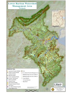
Wetlands of the Lower Raritan Watershed, Map by Jeanine Kopec-Zanghi
Rutgers Professor JeanMarie Hartman, Director of the Hartman Lab of Watershed Systems Studies, spoke on the importance of preserving riparian areas around streams as “buffer zones” for stream and habitat protection. She explained that the best type of “green infrastructure” for flood protection is the kind that doesn’t have to be engineered or installed – it is the natural “infrastructure” already found in forests and wetlands. It is best to keep a 300-foot buffer zone around streams in order to keep the stream itself, its inhabitants, and the surrounding watershed healthy. Professor Hartman explained these conclusions as almost common sense, but provided findings from an ongoing study of watershed management in Lower Raritan Watershed streams (Bound Brook and Lawrence Brook) that demonstrate a positive relationship between forest and wetland cover and biological water quality.
The study measured the presence of three groups of macroinvertebrates (aquatic animals) in the streams to determine stream health. Certain macroinvertebrates are more or less sensitive to environmental pollutants, and they can be grouped thusly:
-Pollution Intolerant (mayflies, stoneflies, caddisflies)
-Pollution Sensitive (dragonflies, damselflies)
-Pollution Tolerant (aquatic worms, midge larvae)
The presence of more pollution intolerant or pollution sensitive macros in a stream signifies that the stream and its waters are unimpaired, since they cannot live within polluted waters. These are often found in shaded streams with low levels of fine sediments, which not surprisingly are often streams with significant riparian buffers.
Next, Jessica Jahre of Princeton Hydro spoke on the importance of healthy floodplains. Floodplains are the areas surrounding streams and rivers that flood periodically, relating to risk. We often hear of 100-year or 500-year floods, but recently, we have seen more frequent and more intense flooding in the Lower Raritan Watershed. Floodplains are expanding, and more people are being put at risk for residing in or near the floodplain. Ms. Jahre explained that a healthy floodplain is integral for mitigating flood risk and damage in our communities, and she explained how she works with flood claims data to identify the areas most at risk.
It is important for a floodplain to be healthy in order to not only reduce instances of flooding, but also to improve water quality, recharge aquifers, and create wildlife habitat. It is often the case that floodplains have to be enhanced from current degraded conditions. This process includes reforesting or naturalizing (removal of development) floodplains, reconnecting the stream to the floodplain, lowering the floodplain through re-grading, or hydrologic restoration (eliminating abandoned agricultural ditches, removing dams). The problem we face in New Jersey and in many other densely populated areas is that development often comes right up to or is centered around rivers or streams, which only become more prone to flooding as the floodplain becomes more impaired through development and deforestation. In order to minimize future risks from flooding, we must enhance and improve our floodplains statewide.
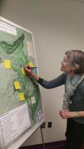
Susan Edmunds identifying riparian areas of interest
Thank you to our wonderful speakers and attendees. Next up in the speaker series are presentations on Lower Raritan Watershed recreational assets and neighborhood, cultural, and historic assets. Please join us on March 15 from 9:30am-12:00pm at the Middlesex County Administration Building, 75 Bayard Street, New Brunswick.
Speaker themes for 2016 include natural resource assets, cultural and historic assets, transportation and mobility assets, seeing brownfields as community assets for restoration, and economic assets, innovation, & regional planning. We are very excited for the opportunity to have state and regional experts on these topics join us for these presentations, and we hope you will join us as well! Please see our events page for more information.
by Heather Fenyk & Elizabeth Dabundo
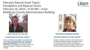
Join the LRWP from 9-noon on February 16th when we will hear presentations on Natural Resource Assets by John A, Miller, Princeton Hydro Water Resources Engineer and co-founder and legislative committee chair for the New Jersey Association for Floodplain Management and Rutgers Professor JeanMarie Hartman, Director of the Hartman Lab of Watershed Systems Studies at Rutgers.
Natural Assets Map Project Background
In February 2015 at a workshop on Impervious Cover Remediation (ICR) co-hosted by the LRWP and Rutgers Cooperative Extension Water Resources, the LRWP recognized a need for tools to help communities implement Green Infrastructure (GI) and meet ICR goals. At the ICR workshop municipal representatives expressed an interest in minimizing stormwater runoff, with many of of these reps suggesting that their communities set impervious cover reduction targets. But where to start? How could towns best prioritize resources for ICR and GI implementation?
To help LRW communities on this path the LRWP researched tools that would help with strategic location of ICR and GI sites. We found references to a process called “Natural Assets Mapping” that suggests not only a prioritization process, but also provides an approach to orienting community conversations around valuation of ecosystem services and the benefits supplied to human societies by natural ecosystems.
Working with input from the Middlesex County Department of Planning we shaped a speaker series for 2016 to guide development of a Natural Assets Map for the Lower Raritan Watershed (Watershed Management Area 9), and to prime municipal conversations regarding prioritization of GI and ICR.
Our goals for the project include:
- To evaluate, prioritize and map natural and cultural assets in the Lower Raritan Watershed.
2. To support community stewardship of Green Infrastructure (GI) / Nature-Based Solutions, including:
-Informing development of GI Master Plans
-Identifying opportunities to add GI to capital projects
-Helping communities link to GI performance rates
-Helping develop design standards for GI related to identified assets.
3. To identify potential investments to optimize the existing system.
4. To advance and support stormwater management planning at County / municipal levels.
5. To improve administration of environmentalism in the LRW.
The 2016 Natural Assets Mapping kick-off
At the 2016 Natural Assets Mapping kick-off event on Tuesday January 26, LRWP Land Use Planner Angela Knowles gave an overview of the Natural Assets Mapping process as outlined by Karen Firehock at the University of Virginia. Angela provided highlights of the document we are using to guide our work (“Evaluating and Conserving Green Infrastructure Across the Landscape: A Practitioner’s Guide“) and described the various GIS layers the LRWP plans to discuss going forward.
Angela also explained how, using these layers, we will map environmental, cultural, historic, and human assets throughout the watershed in an interdisciplinary way. With GIS, LRWP communities will be able to see where particular features are found, what geographical patterns exist, and what changes have occurred over a given time period. We aim to identify the natural assets in the watershed and how they relate to other community assets so that we can conserve, and/or restore the natural features that are most valuable to communities. This further reduces the need to build engineered structures to deal with issues like stormwater runoff in favor of more cost effective, natural solutions.
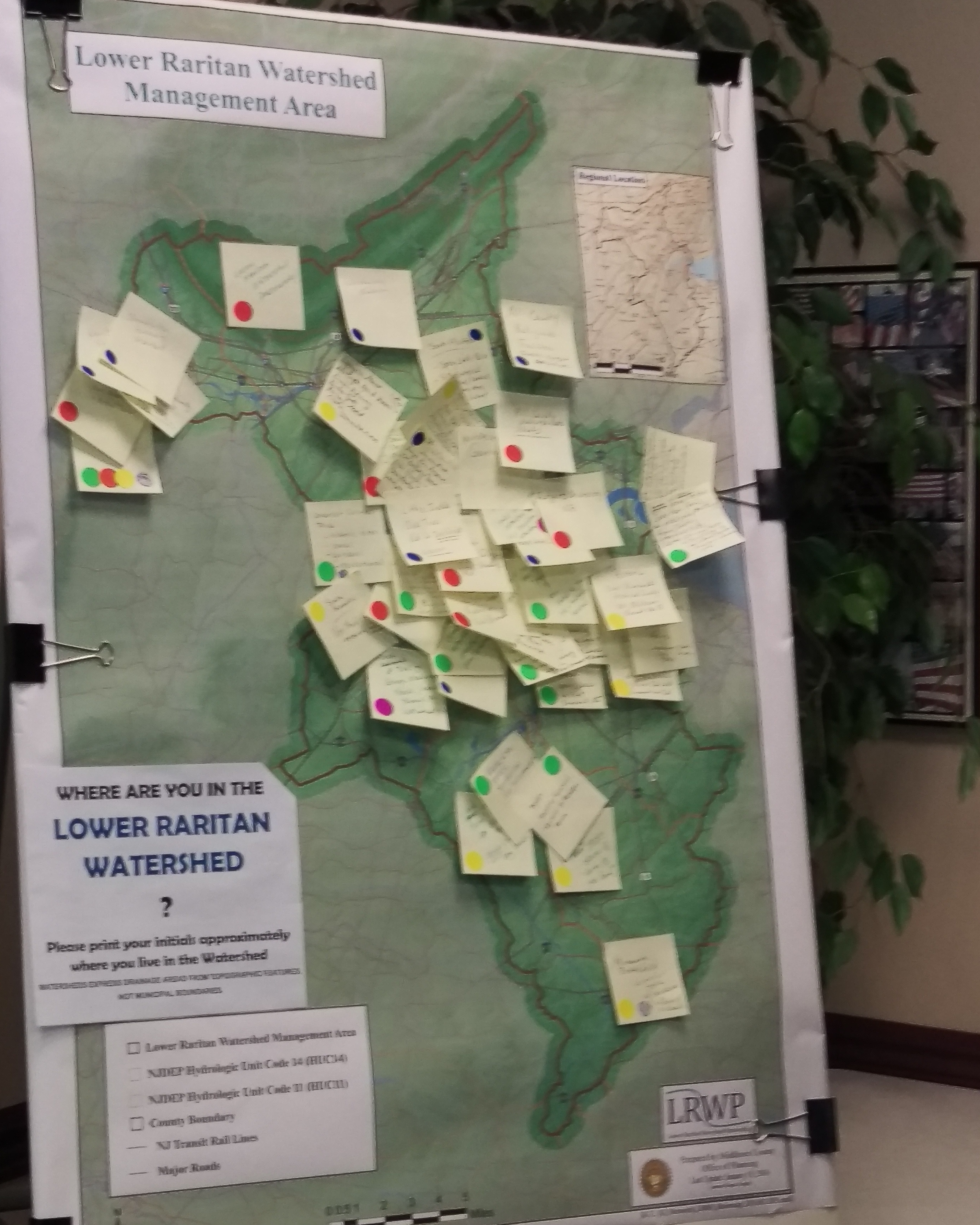
At the kick-off, attendees brought attention to various environmental, cultural, historic, and human assets that they personally thought were valuable in a group mapping exercise. The LRWP will devote much of the year to reaching out to community members around the LRW to pinpoint certain areas that may be less known to many, but no less valuable.

Speaker themes for 2016 include natural resource assets, cultural and historic assets, transportation and mobility assets, seeing brownfields as community assets for restoration, and economic assets, innovation, & regional planning. We are very excited for the opportunity to have state and regional experts on these topics join us for these presentations, and we hope you will join us as well! Please see our events page for more information.