Tag: Hidden Streams
July 24 Watchung Mountain “Hidden Streams” Hike
Registration is now open for the LRWP’s first “Watershed Highlights and Hidden Streams” walking tour of 2021!
Join us on Saturday July 24, 10-noon as we visit one of the northernmost areas of the Lower Raritan Watershed and explore the Watchung Reservation’s Blue Brook and Lake Surprise.
The walk, guided by our own David Tulloch, will help our hikers begin to discover this massive Olmsted Brothers-designed park. With help from a few maps, Dr. Tulloch will talk about the context of the park within the watershed as well as the context of this culturally-significant historic landscape within the surrounding communities of Union County.
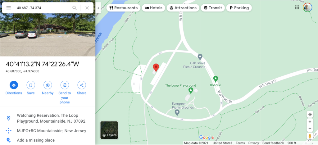
We will be meeting in the Watchung Reservation at the area called The Loop (Some park signs point towards the Loop and its playground). At 10am our group will depart on foot from the building (with bathrooms) shown with the red marker below (40.687, -74.374).
Estimated 4 miles of walking.
Registration required. Please check the LRWP website for updates, especially in the case of inclement weather.
The Watchung Reservation is in Scotch Plains, NJ 07076
The Problem of “Hidden” streams
The LRWP is often asked to identify top environmental issues facing our Central Jersey watershed communities, and every year we develop a “Top 10” list of concerns. Through 2019 we will feature one concern a month on our website, exploring that issue (and potential solutions) in more detail. This month we consider the problems caused by culverting, piping, developing over or otherwise “hiding” our streams, and provide strategies through which we can find them again.
The Lower Raritan Watershed is full of ghost streams. Entrepreneurs, town councils, industry, and home owners have long buried streams to develop their land and businesses, to expand their towns, to build their homes, and to address public health concerns. The result is centuries of piping, culverting, construction, and development that have hidden the vast majority of streams and rivers in our urban landscape.
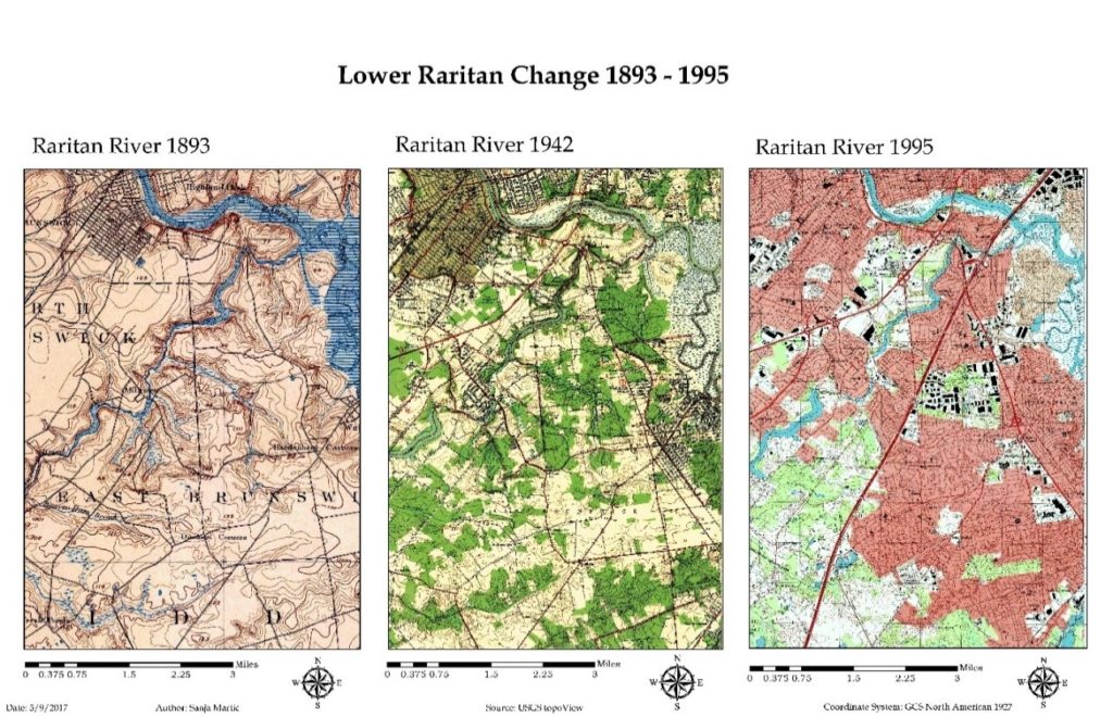
“Lower Raritan Change: 1893-1995”
This graphic show gradual encroachment of development and associated disappearance of tributaries to the South River and Raritan River over a period of approximately 100 years.
Sanja Martic, 2017.
The impact of “hiding” so many of our streams is devastating. Lower Raritan communities are alienated from our waterways and historic ecologies, habitats are degraded, water quality is compromised, and stormwater runoff and flooding intensify. Not only in the Lower Raritan, but throughout the United States and globally, these impacts are most acutely felt in areas with low socioeconomic status and vulnerable populations. In the face of climate change and increased precipitation and runoff, these communities bear disproportionate risk and adaptive burden.
We know that healthy, open streams play an important role in stormwater management. In a healthy stream, stormwater gets absorbed and gradually released by soil and plants. An open stream not only slows and controls stormwater surge, it also provides habitat for wildlife, and provides the aesthetic benefits of cool spaces and greenery.
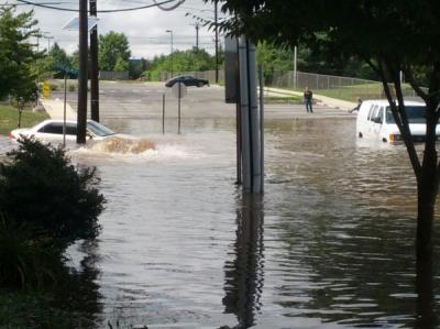
A Stream (Mile Run Brook) Runs Under It
Flooding on Joyce Kilmer Avenue at the Mile Run Brook culvert strands students at New Brunswick’s Greater Brunswick Charter School Photo: Charlie Kratovil, 2016
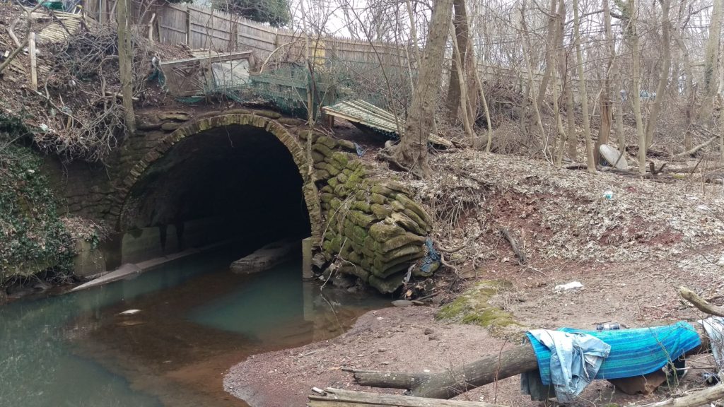
What is a culvert? A culvert is a tunnel carrying a stream or open drain under a road or railroad. Stagnant water in Mile Run Brook under New Brunswick’s Hamilton Street culvert.
Photo: Heather Fenyk, 2019
Streams, especially small ones, also play an important role in improving water quality. A healthy stream ecosystem can remove excess nutrients, sediment, and other contaminants from water before it flows into our Rivers, Bays or Oceans. Recent research by the Environmental Protection Agency found that nitrates—nutrients that can become pollutants—travel on average 18 times further in buried urban streams than they do in open streams before they are taken out of the water column. This means that in areas with many buried streams like the Lower Raritan Watershed, larger water bodies including Raritan River and Raritan Bay receive more pollutants than if the waterways upstream were open and healthy and serving to filter pollutants as stormwater runoff travels its course.
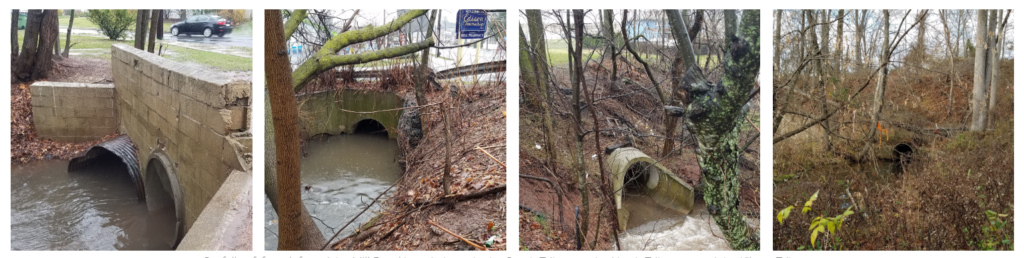
Except for the smallest tributary, all branches of Mill Brook first meet daylight at the end of concrete pipes. Outfalls of, from left to right, Mill Brook’s main branch, the South Tributary, the North Tributary, and the Kilmer Tributary (Highland Park and Edison). These photos are part of Susan Edmunds’s Storymap: “Mill Brook: A Portrait of an Urban Stream”
Of course the best first action with respect to keeping streams healthy is to avoid culverting, piping, constructing over or otherwise developing them. However, in already heavily developed areas like the Lower Raritan Watershed, much damage has already been done. In some of our Lower Raritan towns more than 50% of surfaces are paved over, including all waterways that were in evidence on maps from the 1800s.

Change in time in impervious cover in the Lower Raritan Watershed from 1995-2012
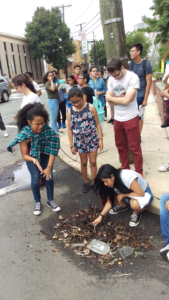
Walk down most any of our main streets and you are likely to “walk on water” without any awareness of what is beneath your feet. If you pay careful attention however, as students did during our 2018 summer camp, you can hear the streams and trace their course, even if you cannot actually see them. Learning about our landscape, and “finding” our hidden streams is the next best action to take in protecting them.
Learning to decipher our landscape, and trying to “find” our hidden streams are central to the LRWP’s new #lookfortheriver campaign.
The LRWP is building the #lookfortheriver campaign to bring attention to the problems of “hiding” or disappearing our streams, and to identify ways of finding them again. In addition to teaching folks about the landscape in fun ways, this involves collecting stories by volunteers and contributors who take the time observe and document their area streams, and who highlight the great benefits of landscape connectivity. Joe Mish’s most recent February essay is a great example: Along the South Branch Connected. Margo Persin’s year of blog post’s about Ambrose Brook is another.
#lookfortheriver activities include our newly launched “Watershed Highlights and Hidden Streams: Walking Tours of the Lower Raritan Watershed,” to be led by Rutgers Professor and LRWP Board Member David Tulloch. These walks will look at landscape connections to our waterways and what this means. The series kicks off on Sunday March 16 close to the Rutgers campus, with exploration of the connections between Buell Brook and the Raritan, connecting Johnson Park and the historic Raritan Landing with the Eco Preserve.
#lookfortheriver includes working with volunteers to understand how our landscape works, where it doesn’t, and how to fix the problems we observe. Susan Edmunds’s research into the history of Mill Brook, and her careful study and documentation of the stream (see her online Storymap Mill Brook: A Portrait of an Urban Stream) lends tremendous insight into landscape functions of a relatively forgotten stream. Susan will present on this project in at the Highland Park public library on Sunday March 24. Joining Susan will be Rutgers student Jillian Dorsey, who will highlight findings from her thesis research on Mill Brook that shows how property owners can protect their urban streams. We hope these efforts will further mobilize municipal action to restore local streams, and that they will inspire homeowners in proper maintenance of waterway-adjacent homes. In fact, this work has already inspired the Highland Park Council to partner with the LRWP for a multi-site clean-up of Mill Brook, scheduled for Sunday May 12 – please save the date!
#lookfortheriver also includes ambitious proposals to “daylight” local streams. One such proposal is for New Brunswick’s Lyell’s Brook Green Infrastructure Landscape Corridor.
The legacy of development, culverting and piping that has hidden our streams exacerbates flooding and pollution transfer. It has disconnected us from our waterways and from our land. This is disastrous for our communities, but we are learning new ways “find” our streams again and fix these problems. Join us in online to discussions, at meetings, or for our “Hidden Streams Walking Tours”. Or simply start exploring the watershed on your own. Give close attention to landscape cues – the sound of rushing water in a storm sewer, collections of sediment and debris in low lying areas, and dense growth of trees and weeds. In this way we connect to our landscape and waterways, imagine their past, and can begin to plan for a future of “finding” and restoring them.
Please join us as we #lookfortheriver
May 18 – Watershed Highlights: Duke Island Greenway walking tour
Join LRWP Board Member Professor David Tulloch as he leads our second “Watershed Highlights and Hidden Streams” walking tour of 2019!
Professor Tulloch will help us connect the old constructed landscapes of the canal at Duke Island County Park through a new greenway / bikeway that has been developed along the Raritan and crosses over into the Duke Farms properties. Many area residents are likely familiar with individual pieces of these recreation spaces. Fewer have made the walk to connect them all.
We expect to traverse 3 municipalities (and a named community that locals assume is a 4th municipality), and learn about the role that James Buchanan Duke played in shaping the hydrology of the area including creating multiple dams on the Raritan River to channel water to man-made lakes on the Duke Farms grounds.
Professor Tulloch says: “With the pump house and former dam, I think this will really be more about history than the hidden streams. But there are some interesting spots along the river where small streams contort themselves to cross the greenway.”
Join us from 9-11 AM on Saturday May 18.
Please park at the lot marked as the Raritan River Greenway on Old York Road between Woodmere St and Chestnut St, just barely inside Raritan Borough.
Registration required.
As we will not enter into Duke Park lands, dogs are allowed on this walking tour.
