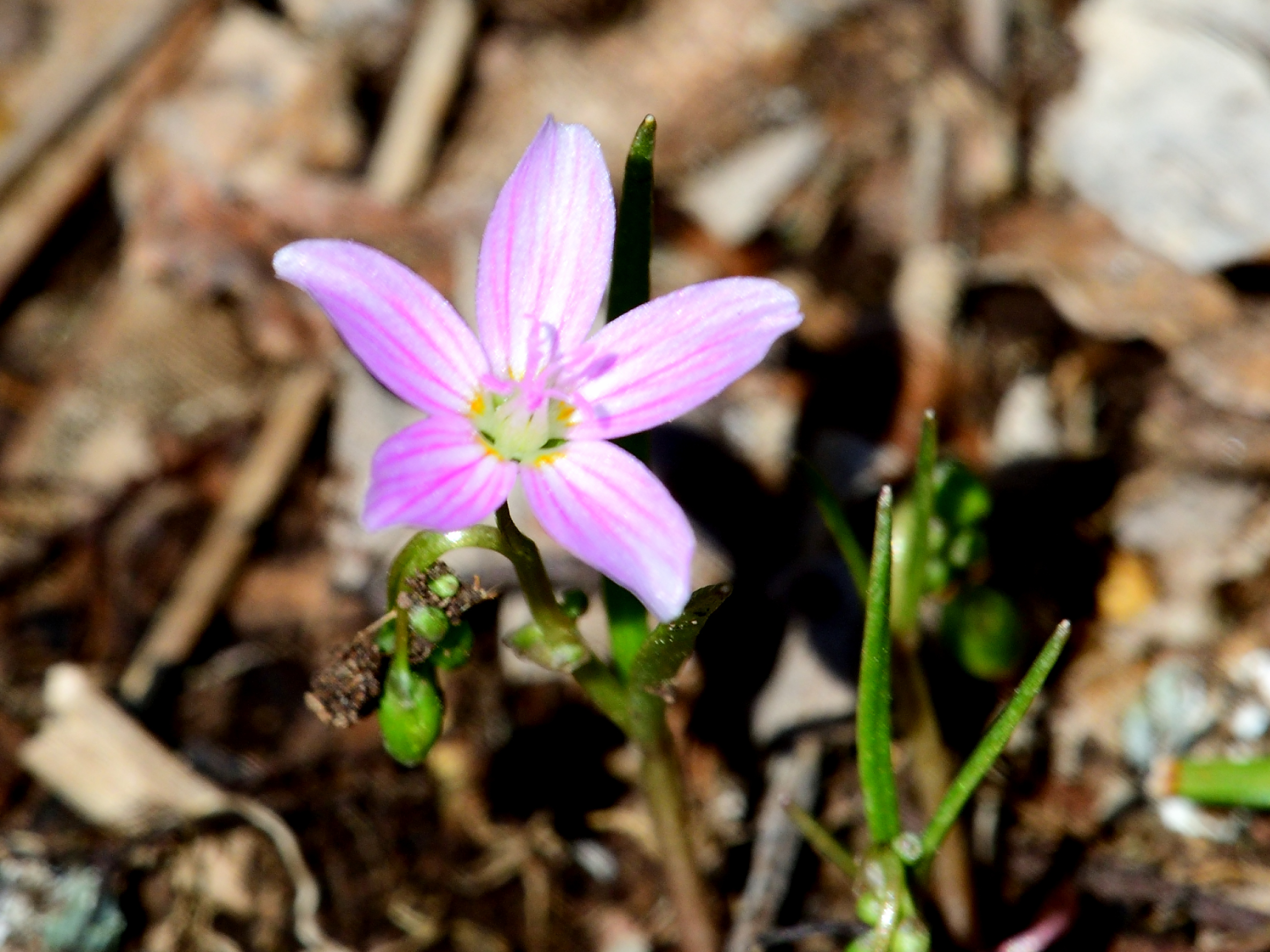
There is magic in the first wildflowers which dare to dance in April’s cool breeze. Look closely at the pinstriped Spring Beauty to see the face of an impish sprite staring back.
March knocks on April’s door, and standing there on the dim lit stoop is a visage surrounded by swirling ice and snow, dripping mud and melting frost. Without hesitation, April invites the disheveled traveler in and notices a small parcel wrapped in green, wet with melted snowflakes. It is the gift of spring, and with it comes the remnants of the wintry month’s mercurial weather. As April encourages the sun to stay a while longer each day, the influence of March’s wintry heritage is diminished. A mere promise of favorable conditions is enough to encourage a veil of green to emerge from the cold ground in a resurrection of dormant life.
Within this transitional framework, the brilliant tints of green enliven the dull gray landscape to rouse curiosity and focus attention toward the earth. Energy is a key element in attraction and April is a time of palpable and boundless energy. The invisible movement of time appears betrayed as plants seem animated and grow before our eyes. Many spring plants have a narrow window of opportunity to emerge and mature, so their growth is accelerated.
Spring beauties are ephemerals which grow in isolated patches in open woods and among short pasture grass, their pink and white stripped flowers linger into May. Each short-stemmed flower is distinctly different in petal stripe and color. Some variants are almost all white with faint pink stripes, while a neighboring patch may be dominated by deeper pink petals and dark pink stripes. Color and pattern variations are the rule, which makes this flower so interesting. The variation in a way, compliments the vagaries of early spring weather and the individual character each April presents.
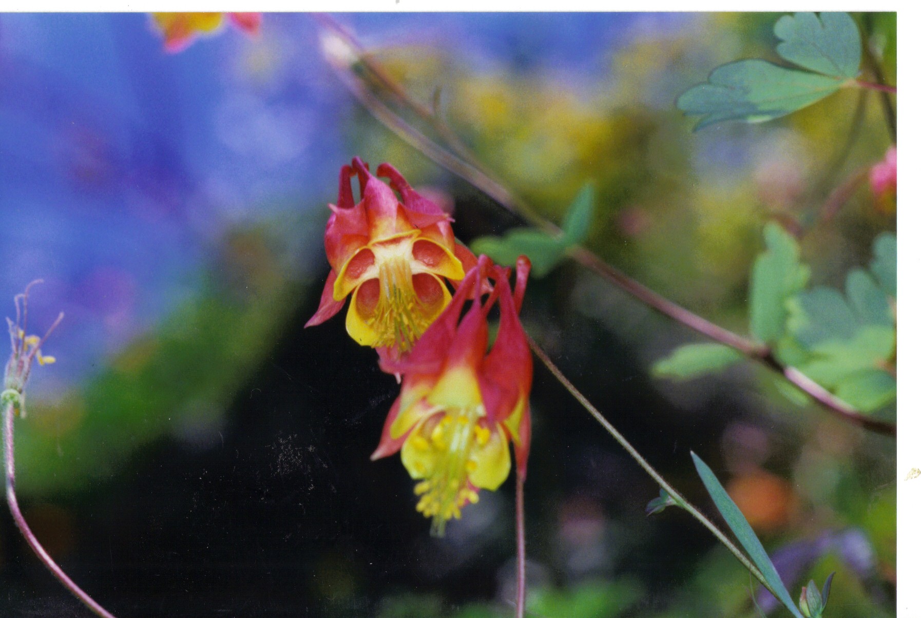
A calendar is not needed to know April has arrived. The appearance of native columbine on the red shale cliffs along the South Branch of the Raritan are as dependable a sign as any numeric score card. There is security in predictability and despite changing weather patterns, columbine remains faithful to April.
Native columbine is a delicate long stem, dark red, inverted, single bloom, composed of four or five individual vase shaped tubes, which collectively terminate in the appearance of a crown where the inverted flower meets the stem. Each tube within the red flower is lined with bright yellow. A distinctive broad, three lobed, pale green leaf adorns each stem and easily catches a breeze to help disperse seeds when the plant matures in early May. Columbine does not grow in profusion and is best described as being found in isolated villages, tucked in among the maroon cliffs. I wonder how many Aprils these cliff dwelling plants have seen, as their existence in such an austere shale environment is not conducive to random dispersal. I think of Brigadoon, a mythical village that appears once every one-hundred years, when native columbine appear during April, on the face of ancient cliffs, otherwise devoid of life.
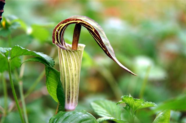
April’s charm and promise find a spokesman in the form of Jack in the pulpit. As the name implies, this early spring plant appears to portray a minister standing in a raised pulpit, leading the congregation in prayer and praise for the gifts of nature. The personification of this unique plant, based on its shape and form, perfectly fit myth, magic, and folk lore promoting a human/ plant interface. The appearance of Jack standing in a pulpit, could be perceived as a reincarnation or memorial to a revered patriarch.
Any natural phenomenon begs for an explanation, and in this way, April delivers a lesson in the most critical of survival tools, creativity, and imagination. The earliest flowers to appear under April’s umbrella are a sign of hope as they stand in sharp contrast to the stark landscape about to awaken. Consider that flowers are living things that in some magical way, recruited man to further their propagation in exchange for a glimpse of eternal beauty, dreams and imagination. All combined to expand the universe of human potential with unbounded creativity and expression.
April has opened the gift of spring March delivered, and has swept its fresh green carpet clean of any wintry remnants tracked in when the gift was delivered. Conscious of its fleeting time allotted, April honors the delivery of the next month’s explosion of blooms by taming the weather and warming the soil. When may flowers arrive, April deserves a special thanks.
Author Joe Mish has been running wild in New Jersey since childhood when he found ways to escape his mother’s watchful eyes. He continues to trek the swamps, rivers and thickets seeking to share, with the residents and visitors, all of the state’s natural beauty hidden within full view. To read more of his writing and view more of his gorgeous photographs visit Winter Bear Rising, his wordpress blog. Joe’s series “Nature on the Raritan, Hidden in Plain View” runs monthly as part of the LRWP “Voices of the Watershed” series. Writing and photos used with permission from the author.
Article by LRWP Spring 2024 Intern Alyssa Phillips, Photos by Heather Fenyk
Running from March-May 2024 the LRWP will monitor for Migratory “Spring Glass Eels” in the Green Brook. This eel monitoring project will augment an on-going litter reduction project, including installation of a Litter “Trash Trap” device, along the waterway between Dunellen and Middlesex. This article is the first in a blog series about the migratory eel monitoring and litter reduction projects, and how you can get involved!
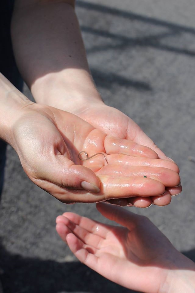
Each Spring, the endangered juvenile American eel, Anguilla rostrata (aka “glass eels”), travel more than 1,000 miles from the Sargasso Sea to coastal estuaries along the United States, including the New York/New Jersey Harbor Estuary. Sometimes these marathon migrators make it even further upstream into freshwater tributaries of the tidally-influence Raritan River.
A single spring glass eel rests in the palm of a human’s hand. The eel is approximately 2 inches in length and is transparent.
American glass eels are catadromous, meaning they spawn in the ocean (saltwater) and then migrate to brackish estuaries to live out the rest of their lives (which can be up to 30 years). American Eels are called spring glass eels in their early stages of life due to their time of migration and appearance. When they are first born and enter North American estuaries the eels are nearly transparent, giving the appearance of glass. Ribbon-like in shape, they average 45-65 mm in length by the time they are 6 months when they begin the upstream swim to their freshwater homes.
One of the biggest issues that American glass eels face are obstacles while migrating. These obstacles range from large litter and trash, to dams and turbines. Additional threats to the glass eels population is habitat degradation and pollution, including stormwater runoff.
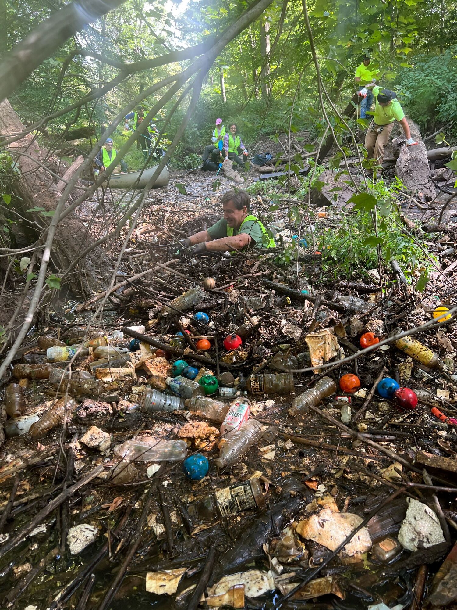
In the foreground a community volunteer stands chest deep in the trash filled waters of the Green Brook, near the site where the Trash Trap device will be installed.
From March-May 2024, the Lower Raritan Watershed Partnership is conducting a two-part habitat study to learn whether Spring Glass Eel make it as far as one Raritan River tributary called the Green Brook, and whether removal of trash blockages along the Green Brook waterway aids their passage. Through the LRWP’s Glass Eel Community Science Monitoring Project the organization will catch and count the number of juvenile Spring glass eels found in a portion of the Green Brook River prior to, and after, the installation of a mechanical pollution reduction device called a Bandalong Bandit “Trash Trap”. The project study site is located in Dunellen at approximately Jefferson Ave.
By catching and counting Spring glass eels in March, the organization seeks to establish baseline data regarding the presence of these animals in Green Brook prior to the implementation of a pollution reduction device. Monitoring for the presence of Spring glass eels in May, after the April installation of the Trash Trap, will give a sense of whether the trash trap positively or negatively impacted a critical species of aquatic wildlife.
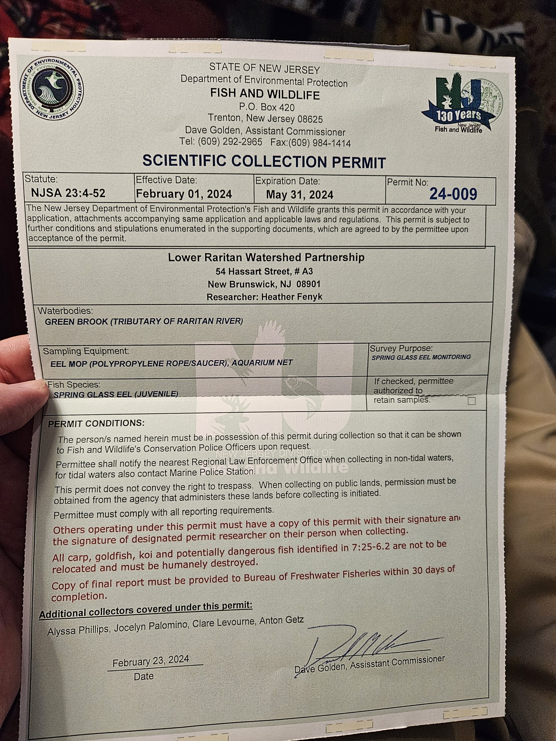
A photo of a document, titled ‘Science Collection Permit’. The permit lists the location of the site (Green Brook, Tributary of Raritan River), sampling equipment (EEL Mop and Aquarium net), and the permit conditions.
Goals of this community science project include supporting community members in hands-on science studies, and connecting youth with the beauty and fascinating habitat of often overlooked urban streams. By linking glass eel studies to trash reduction efforts, we also seek to bring attention to the positive impact of community clean-ups, as well as to support public understanding of the Green Brook waterway as a vibrant aquatic habitat. We anticipate that the reduction of plastic debris will benefit aquatic and semi-aquatic wildlife, like that of the Spring Glass Eels, by reducing microplastic ingestion, reduce potential exposure to contaminants, and allow for easier migration upstream by removing trash blockages. Join us!
With many thanks to the NY/NJ Harbor & Estuary Program and the Hudson River Foundation for their generous support of this program:
Article by LRWP Streamkeeper Coordinator, Jon Dugan
In this month’s volunteer spotlight, we are going to learn a little bit about the Ambrose Brook and one of its volunteer Streamkeepers, Mike Vacca.
Ambrose Brook Streamkeeper Mike Vacca on the left, with LRWP Streamkeeper Coordinator Jon Dugan
Ambrose Brook is a tributary of the Green Brook in Middlesex County, New Jersey in the United States. The Ambrose originates underneath what is now a Volkswagen dealership along Route 27 in Edison. It then flows into Lake Papaianni, which is within an Edison Twp. municipal park. The Ambrose then continues flowing northwest, parallel to County Route 529, eventually crossing Route 529 and Ethel Road West, it forms a border to some businesses in Piscataway.
Upon flowing into Lake Nelson, the brook takes a more westerly route into Ambrose Doty’s Park. The brook then takes a southwest turn and flows into the Green Brook near Lincoln Boulevard in Middlesex just before the Raritan River. During this entire course of flow, the LRWP monitors two key locations along the Ambrose Brook, selected for the location to their confluence.
Mike Vacca is one of the Streamkeepers for the two sites along the Ambrose Brook before it connects with the Green Brook. Mike started his volunteer days with the LRWP back in May 2019, where he started learning about the Visual Monitoring Program. He volunteers for the Spring and Fall session on monitoring, and often will attend workshops to sharpen his habitat-assessing skills. Mike takes measurements and graded-evaluations of the stream in order to give it an overall Habitat Assessment score. These scores are compared with prior years to “paint a picture” of the stream health of the course of several years.
When Mike is not out monitoring the Ambrose, his interests are gardening, hiking, movies, music, painting, video games, and spending time with his nieces. Mike also likes collecting glass and interesting looking rocks (especially ones that he finds when walking up and down the river or hiking). Keep an eye out for him the next time you find yourself in the Ambrose Brook watershed!
A fox sparrow takes refuge from a late March snowstorm as it migrates north to its breeding grounds
The fluffy white blanket of an early March snowstorm, preserved by the cold days that followed, began to shrink as the sun fought the darkness for dominance. The snow cover was still unbroken as it grudgingly settled lower each passing day. Eventually the white blanket would lose its loft and become threadbare, unveiling the gravid brown earth.
The days following the storm dawned clear and cloudless. The night sky was a showcase of brilliant white diamonds, alive with energy as they sparkled in the infinite celestial darkness.
An hour before sunrise the west facing snow covered hillside reflected enough light to reveal the fine detail of the skeletal silhouettes of every tree and bush that stood above the white ground cover. Even as the sky began to brighten, the entire hillside remained in shade, preserving the dramatic pre-dawn contrast. For a few slow minutes, the sky above the hill was bathed in a diffuse aura of gold, fading into white, which blended into the palest blue, growing more intense as the brightest stars lingered and were lost among the deepening blue background. For a long moment, night and day, past and present coexisted at one glance. The dynamic scene, frozen on an imaginary vertical tapestry, the black and white hillside held in sharp contrast to the gold and sunlit blue sky above.
In a way, that dawn was symbolic of the dichotomy of March, as the month ushers in the last cold breath of winter and departs amid life emerging from dormancy under the influence of increasing daylength.
Maroon, orange, green, and red buds decorate the bare tree branches to rival fall color, as early spring flowers tolerate the mercurial weather and defiantly poke through any errant late Match snowfall.
Bird migration is now in full swing as flycatchers, osprey, and colorful warblers make their appearance.
Great horned owls, hatched a month earlier, are flightless and near adult size.
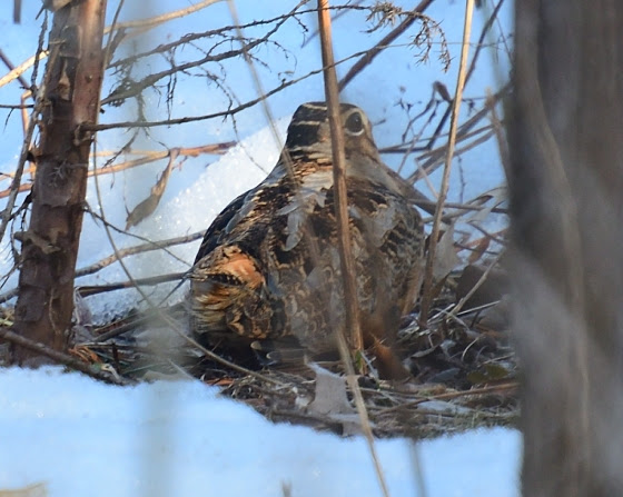
March is the best time to find migrating woodcock and observe the unique mating flights performed by the males at dusk, choreographed to impress a potential mate. Woodcock were common locally in open woods and damp fields. As habitat dwindles, any sighting becomes a rare treat. When March rolls around I head for a likely spot where a swale is formed by the earlier mentioned hillside. The hillside is drained by a seasonal stream which remains wet where the gradient levels. The saturated soil creates a perfect environment for earthworms, the main food source for migrating woodcock. Woodcock, also known as Timberdoodles, will often sit tight and allow a close approach.
All migrating birds must deal with unpredictable weather anywhere along their migration path. So, arrival at any one location will vary from year to year. It is somehow comforting when birds that migrate through, show up on schedule. All is right with the world. When snow buntings, headed to points north, stop over at a specific location year after year, a dependence of sort can develop on behalf of the observer. The snowbirds become a reference point, much as a birthday or anniversary.
March provides the ‘wind beneath the wings’ of migrating birds as well as sweeps the land and grooms the trees, wind and March are inseparable.
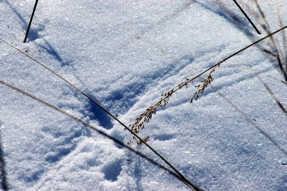
March has earned the reputation as the month of relentless wind as it rushes mercurial weather on and off the stage to stir the breeze. Think about the wind and the scale of expression from hurricanes and tornadoes to a gentle whisper, where the wind uses a dried stem of grass or tree branch to etch its thoughts in the snow or on the side of an old wooden barn.
The first day of spring will happen on the nineteenth day of March, 2024, at 11: 06 pm. Day and night reach perfect equilibrium for a split second as winter surrenders to spring.
Author Joe Mish has been running wild in New Jersey since childhood when he found ways to escape his mother’s watchful eyes. He continues to trek the swamps, rivers and thickets seeking to share, with the residents and visitors, all of the state’s natural beauty hidden within full view. To read more of his writing and view more of his gorgeous photographs visit Winter Bear Rising, his wordpress blog. Joe’s series “Nature on the Raritan, Hidden in Plain View” runs monthly as part of the LRWP “Voices of the Watershed” series. Writing and photos used with permission from the author.
Interview conducted by Rutgers Spring 2024 Intern Maxim Pavon
Maxim Pavon: What is your earliest or most impactful memory with the Raritan (watershed)?
Alex Zakrewsky: Having grown up in the Raritan River Watershed, I have many boyhood memories of playing in its tributaries. As a free-range kid, my buddies and I would often walk unescorted to local streams to fish, turn over rocks to find crawdads, and build temporary stone and mud dams across rivulets. Hours would pass like minutes as we were totally engrossed in observing and interacting with the moving water and the plants and animals it supported. Sometimes a misstep (a “soaker” in our vernacular) would muddy my sneakers, socks, and pants—earning me a stern scolding from my mother when I eventually arrived home!
MP: At that time, did the people around you, friends and family, see what you saw in the watershed?
AZ: I was not unique in my explorations of the watershed. It was quite common for the working-class boys in my neighborhood (and there were many of us- we were on the tail-end of the baby boom, after all) to entertain ourselves by romping in the stream-side woods. Some would try to make some money by trapping muskrats, then skinning and selling their pelts to Schwendeman’s, a taxidermist and fur broker on Main Street in Milltown. My friends and I sometimes harvested cattails, dried them in the summer sun, and sold them to boutiques for sale as decorative displays. Otherwise, dried cattails (or “punks” as we called them) would make excellent slow-burning lighters for firecrackers on the fourth of July. On other occasions, my friends and I would cut 10-foot-tall bulrushes for use as “lances” as we “jousted” on our bicycles. These were mostly activities for boys and young men, however. Young ladies stayed away, and older men were too busy working in the many factories that dotted the riverbanks.
MP: Throughout your life, who or what has been a continuing source of inspiration for you to pursue the path you are on?
AZ: I am at heart a family man, and I do what I can to support my family. My wife Heather Fenyk is a continuing source of inspiration in her role as LRWP President—her work ethic and effort in this non-paid position is a sight to behold!
MP: What do you hope to accomplish/implement as a Principal Planner with Middlesex County?
AZ: I work with a team of Professional Planners and Licensed Civil Engineers to enhance safety, accessibility, and drainage along County Road rights-of-way.
MP: As Co-founder of Middlesex Apartments, LLC. How has the business’s mission fit in the scope of the watershed?
AZ: Part of the Middlesex Apartments, LLC property portfolio consists of a farm in Princeton, which lies in the Raritan River basin. We are currently exploring restoration of the wetlands on the property, improving the quality of runoff first into the Millstone River, a tributary to the Raritan. We also manage the farm sustainably. This includes using solar for energy, farming without using pesticides and herbicides, letting the goats (instead of mowers) keep the brush down, etc.
MP: As far as the LRWP goes, what has been the biggest hurdle?
AZ: As an organization that has no paid staff, the workload is always vastly greater than the resources available to do the work.
MP: Where have you seen the most growth?
AZ: Since its inception the LRWP has tripled the size of its Board of Directors, and with very accomplished and qualified members. Activities have grown beyond the original stream clean-ups to encompass public boat builds, a wide variety of kinetic and visual artistic displays, water quality monitoring, river tours, kayak floats, presentations, lectures, and numerous and sundry outreach efforts. Revenue from donations and grants has also grown and continues to expand at double-digit rates.
MP: What is something you can tell the people who don’t believe in the LRWP’s mission?
AZ: I would remind them that improving the health of the watershed also brings benefits to them and their families. Our own health and sense of well-being is inextricably tied to the health of the watershed’s ecosystem.
MP: We would also like to get to know the real you! Do you have any hobbies that have nothing to do with watersheds?
AZ: I think I read more than the average person—mostly current periodicals, but also books on historical topics. In recent years I’ve become a fan of YouTube—I like to listen to experts in various fields including anthropology, sociology, philosophy, economics, geopolitics, and military affairs. I also have a keen interest in matters demographic. I developed a model that estimates and predicts the movement of the United States Population Centroid. My annual calculation and commentary on changing US settlement patterns is reported upon in the national and international press.
Ice encrusted holly berries are the artistic rendering of a late winter freezing rain. Their brilliance is highlighted within a sparkling clear coat of protective ice.
On behalf of winter, February’s frigid embrace lingers for a conscious moment longer as this month exercises its optional twenty-ninth day. The additional day is a correction needed to synchronize derived calendars with the celestial choreography. So, in that way February provides the Wite-out corrective paste to adjust the pending error, and in its enthusiasm, covers the land with snow on occasion, to white out conditions as a failsafe.
As the cold breath of February sweeps across the land, ice and snow are left in its wake to accumulate and be redistributed by frigid winds under threatening skies. Winter offers a complete menu of frozen variants, all based on moisture du jour, altitude, wind speed and temperature. Viscous rain drops, best described as slush, resist the conversion to flakes of snow and accumulate as sheets of crystal-clear ice on tree branches, roads, and windshields.
A rare phenomenon known as a ghost apple, occurs when clear ice envelopes a dried shrunken apple still clinging to the tree. For all appearance the ice covered, mummified pome, is perfectly fitted with layer upon layer of clear transparent ice. The form fitted ice cover eventually accumulates to mimic a full-size apple carved in perfectly clear polished crystal. It is as if Michaelangelo was recruited to dabble in celestial ice sculpture.
As late winter daytime temperatures rise above freezing, trees begin to transport sugary sap to their fine branches. Subfreezing nighttime temps then freeze the sap to make the branches rigid and brittle. Strong wind whips the branches against each other, leaving many broken tips. When the sun warms the air, the sap begins to flow like a dripping faucet until the evening cold sets in. As daily temps fall, the drips elongate into icicles of varying length, each containing concentrated sugars, meant to energize buds and promote branch growth. Reach up, break off an icicle and enjoy a natural sugary treat that hydrates and energizes, no unwanted preservatives or added coloring. In a way, eating these cold treats, taken directly from nature’s hand, represent a communion of sort where energy is transferred and assimilated in the manner of a ‘blood brother’ ritual.
When ice is formed, snow is sure to follow. The menu choices are many when it comes to ordering snow. The spectrum of mandated choices ranges from passing flurries to blinding white out conditions. When the landscape is bare, the arrival of the first snowflake is met with great anticipation. The individual flakes are so beautiful and random, magic overcomes the rational as the source of such intricate design. The magic fades somewhat as a thick blanket of white settles upon the washed out, dull landscape. We are still compelled to stare out the window as the invisible hand of a celestial artist paints the world white as we watch.
Passing snow flurries may be the entire show or just an opening act. The snow serves as a ledger in which rarely seen wild residents use their individual mark to sign in.
Fox tracks in the snow note its presence. This image makes a great Season greetings card signed by the fox to you.
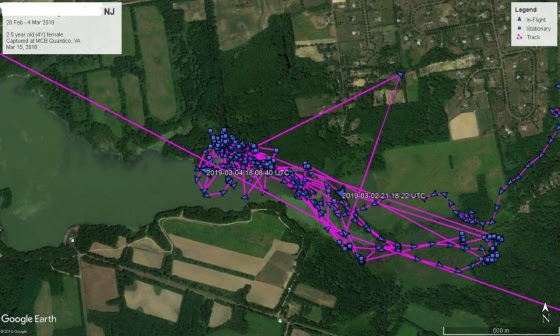
Wildlife is most active at night and away from human habitation. A quick glance of the ledger’s white pages can expose the presence of a whole new world whose expanse had been previously unknown. Tracks in the snow mimic a digital tracking device, not unlike an eagle fitted with a solar powered transmitter, where its travels may be digitally overlaid on a map and viewed on a computer screen.
Screen shot of an eagle fitted with a solar transmitter and its location during one week. Tracks inthe snow are the primitive version of digital tracking.
Note how deer were dining on the honeysuckle just under your bedroom window. See the fox tracks on the back deck.
I always look for rabbit tracks after a snowfall of any accumulation. The question always asked is, “which way is the rabbit going”. Once you figure that out, you realize whether you unknowingly track it backward or forward, the information is the same.
So prolific are the lines of tracks, I imagine the footprints as seams, sewn to hold the expansive white blanket of snow together.
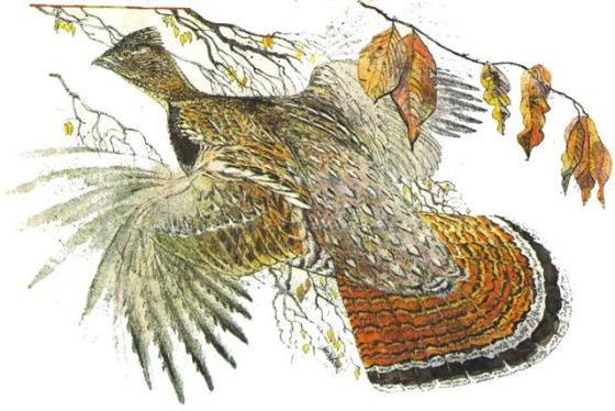
A walk in the woods after a heavy snowfall can offer a rare surprise. Once, more commonplace, ruffed grouse thrived in the mature woodlands locally. Grouse will fly into deep snow creating a tunnel where they rest under virgin snow several feet from the entry hole. Sometimes the entry hole will be covered by new snow, leaving the bird hidden under a perfectly clean blanket of unmarked snow. A hiker may pause for a long moment to marvel at the trackless expanse of snow and revel in being the first to traverse the silent woods that day. The pause in hiker’s steps will cause the grouse to think it was detected by a predator and flight is the only option to escape. Suddenly, the large brown bird explodes from under the trackless snow, steps away from the rattled hiker, the sound of wings furiously grabbing air in a shower of sparkling snow. A pounding heart can be felt once breathing resumes.
Print of a ruffed grouse exploding from cover by Jack Unruh.
February is winter’s last full month installment, just short of full payment, and whether twenty-eight or twenty-nine days, winter loses enthusiasm and concedes the coming of spring.
Author Joe Mish has been running wild in New Jersey since childhood when he found ways to escape his mother’s watchful eyes. He continues to trek the swamps, rivers and thickets seeking to share, with the residents and visitors, all of the state’s natural beauty hidden within full view. To read more of his writing and view more of his gorgeous photographs visit Winter Bear Rising, his wordpress blog. Joe’s series “Nature on the Raritan, Hidden in Plain View” runs monthly as part of the LRWP “Voices of the Watershed” series. Writing and photos used with permission from the author.
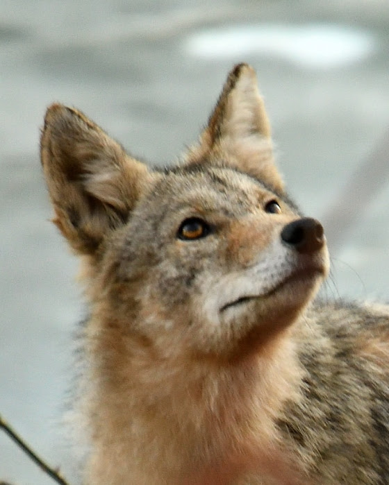
The eyes are windows to your soul, ask not what you think you see in the coyote eyes, ask what you think the coyote sees in your eyes!
The cold November night left a heavy coat of white frost on the still green pasture grass. The sun had just risen, though the open, west facing hillside was still shaded. Topped by a crown of red cedars, the sunlight was further delayed, but the quickly rising temperatures turned the white frost gray. A lead doe worked her way uphill to the edge of the wooded copse, where a love struck buck had earlier left his scent on an overhanging branch. The doe paused her cautious approach and stood absolutely still. Perhaps she detected an unseen buck and had second thoughts of getting too close to a over enthusiastic lothario. Her intense stare was locked on something that raised her concern. Then her tail went straight up and froze in that position while the white hair on its underside and the white hair on her rump bristled out like quills on an agitated porcupine. She remained in that position for more than a minute before she quietly turned and silently left the area, retaining her high flag and bristled rump. Typically, an alerted doe will snort, stamp her foot and do an exaggerated high stepping prance to alert her companions. This was a deviation from normal but probably just the way she conducts business. Two minutes later a coyote appeared from the dark tree line, tail tucked, and headed directly toward me. The gray frosted grass, still in the shadows, complimented the coyote in tone and color to make it appear as an apparition, exempted from earthly constraints. It stopped about twenty paces away to consider its path and trotted along the edge of a mowed strip of grass to parts unknown.
An encounter with an eastern coyote has become more common in New Jersey, the state least expected to host a living symbol of remote and wild places. More often heard than seen, the coyote makes its presence known with midnight serenades that make your hair stand on end as a chorus of howls and yips fill the night air.
It is interesting to trace the occurrence of coyotes in New Jersey and recognize the fallacies and misleading information from media and biologists, some based on politics, evolving wildlife management goals or best guess projections derived from limited available data.
The first coyote officially recorded in New Jersey was in 1939. A mid 1980s Star Ledger article, quoting a state biologist, claimed the first coyotes appeared in NJ in 1958. The same article noted the animals migrated south from New York which hosted an estimated population of 5,000 coyotes. In 2011, the New York coyote population was placed at 30,000 plus and remains stable based on current estimates. The New Jersey coyote population is given as a range of 3,000 to 6,000 animals.
Wildlife population estimates are based on the latest statistical models and surveying technology, which may explain a dramatic jump or decline in targeted populations.
At any rate, sightings in New Jersey were sporadic until the early 1970s, possibly based on misidentification, unexpected presence and a limited, but expanding coyote population.
The Star Ledger article lists a steady chronicle of coyote sightings, mostly in rural areas.
Locally, a coyote made the news in the late 1980s when it was killed by a car near the intersection of routes 28 and 22 in Bridgewater. Another was sighted and photographed in North Branch in 2004.
Today coyotes have moved into cities and towns and have been reported in all twenty-one New Jersey counties.
Local residents have digitally captured numerous coyotes in backyards and along roadsides.
This demonstrates their ability to transition from rural to suburban environs and defies the early characterization of being strictly tied to woodland and farm.
Biologists predicted, in 1985, that the ‘pioneer population’ would never reach significant levels and will remain present only while farms exist. Even data based predictions must be given latitude and considered dynamic rather than static and ironclad.
The intelligence and adaptability of the coyote cannot be underestimated. Native people held coyotes in high esteem for their trickery and explained away their elusiveness as having the ability to transition from spirit to flesh.
To conclusively define the behavior of any animal is a fool’s errand, especially with coyotes. We get the typical, ‘they avoid humans at all cost’, as the litany of coyote attacks grow. Livingston, Fairfield, Piscataway Kinnelon, Middletown and High Bridge have made headlines for attacks on humans. Not to say coyotes are stalking school bus stops and toddlers, but the possibility of an attack exists, though very uncommon. Given the number of coyotes interspersed among the dense human population, pet dogs far outpace coyotes in dog bites man headlines.
Each ‘attack’ must be examined to prevent characterizing coyotes as blood thirsty demons. Rabies is endemic in wildlife populations and known for producing aggressive behavior. Wild canines established relationships with humans to the advantage of both. So, acclimating a fox or coyote to accept handouts is a natural progression. Losing fear of humans as a result, can be misinterpreted as aggression and sign a death warrant for their learned adaptive behavior.
Somerset county set a bounty on wolves in June 1682. I cannot help but wonder if some of the wolves were crossed with coyotes.
Science does its best, though its knowledge base is constantly evolving and interpreting collected data is more of an art form and often tips objectivity to the subjective side of the scale.
Toward that end of gathering information to make better decisions, NJ Division of Fish and Wildlife is asking the public for information on coyotes and other species to help track and manage targeted wildlife populations.
Coyotes have their place in our ecosystem and deserve our respect and understanding, and as with most new information or situations, must be approached with an open mind.
Author Joe Mish has been running wild in New Jersey since childhood when he found ways to escape his mother’s watchful eyes. He continues to trek the swamps, rivers and thickets seeking to share, with the residents and visitors, all of the state’s natural beauty hidden within full view. To read more of his writing and view more of his gorgeous photographs visit Winter Bear Rising, his wordpress blog. Joe’s series “Nature on the Raritan, Hidden in Plain View” runs monthly as part of the LRWP “Voices of the Watershed” series. Writing and photos used with permission from the author.
Dear Friends of the Lower Raritan Watershed Partnership –
A few highlights of the year are detailed below. Our accomplishments are realized with many thanks to you for the gifts of time and financial support.WE WELCOME YOUR DONATIONS!With gratitude for your continued support!!
Water Quality Monitoring: Raritan River Pathogens Sampling
The LRWP, Rutgers Cooperative Extension of Middlesex County and Interstate Environmental Commission completed year five of civic science pathogens sampling along the Raritan River. 2023 waters were the cleanest yet! Real time data is posted in English & Spanish: https://tessera.rutgers.edu/rrho/
Huge thanks to Volunteer Coordinator Jocelyn Palomino (far left) and Fahrenfeld Lab Researcher Genevieve Ehasz (far right) and some of our wonderful Summer 2023 volunteer water quality monitors!!
We Built Two Boats, and Launched Them!
Boat Build Leads Derek Hartwick, Brian Smith and dozens of youth and community volunteers helped build, and launch a cedar strip rowing scull and a canoe. Boat builds continue in 2024: https://lowerraritanwatershed.org/events/
Awards
Coming on the heels of recognition as a NJ State Governor’s Jefferson Awards Honoree, in November the LRWP received the Franklin Township Council and Environmental Commission 2023 Environmental Stewardship Award. Hooray!
Watershed Restoration
TY to the Cornell Dubilier Superfund Settlement Trustees for project funding – we hired our first employee! Welcome Clare Levourne, who will provide oversight for Trash Trap implementation in the Green Brook at Dunellen!
Environmental Education & Outreach, Arts Engagement
With thanks to a wonderful Summer Institute partnership with coLAB Arts, several hundred students learned about their local environment and how to #lookfortheriver for six weeks over summer break. Students learned about their local environment and how to #lookfortheriver. We reconvened in October for a public flash mob of “The Run Off” where participants performed as…you guessed it…stormwater flows! (stay tuned for the film version in 2024).
Upcoming in 2024: please join us for water quality monitoring, paddles “hidden streams” walking tours, environmental education, clean-ups, rain barrel builds, and so much more: https://lowerraritanwatershed.org/events/
Essay and photos (except as noted) by author Joe Mish
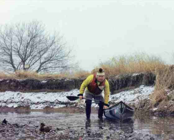
Not on par with Shackleton’s adventure, the intent of this winter paddle trip was to see what nature is doing when she thinks no one is watching. Self portrait
Sleepy eyes involuntarily shut to set the stage for transient dreams to vie for recollection in morning’s foggy consciousness, as a mid-winter storm promised a night of undecided precipitation.
The view through the frosted bedroom window at dawn, revealed the storm’s final decision in the form of powdery snow, preserved by an overcast sky and sub-freezing temperature.
First light of dawn appeared as a proxy of the sun who farmed out delivery of a mere fragment of daylight intended to last the day.
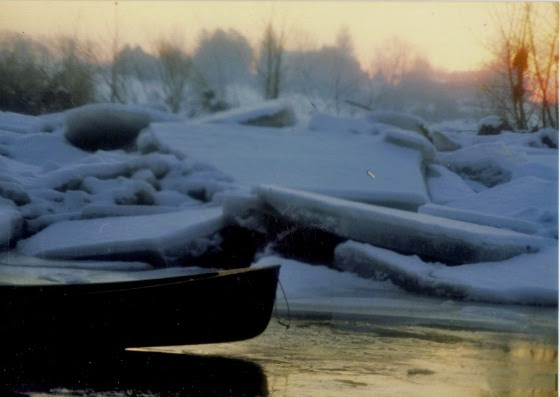
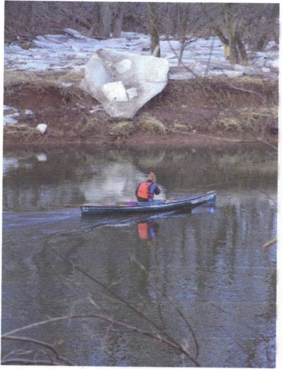
A long spell of cold had locked the river in ice and curtailed any thought of canoeing. A heavy rain followed to raise the water level and break up the ice. The water settled down to a suitable flow, and I was anxious to see the aftermath and capture some wildlife images in between winter’s extreme mood swings.
Predawn light reveals broken slabs of ice, thrown asunder, by swollen water from a heavy rain, followed by a dusting of powdery snow. Moody winter weather is the rule.
The air was still and not a breeze stirred, a sure sign of snow to come. The conditions were perfect, as light snow was expected about halfway through the trip, and it would add mood to any landscape or wildlife images. Wildlife tends to feel more secure and reluctant to move in sub-freezing temperatures, allowing a close approach.
View from the canoe. Digital evidence here, though so many more incredible moments in nature are retained only in the form of recoverable memories altered by time, instead of digital editing.
The camera lens is less likely to get blurred in the absence of wind-blown precipitation. If a stiff breeze was predicted, I would never launch my canoe. Wind is the rate limiting step for my winter sojourns, along with safe water levels. Safety is critical and is weighed against any cold weather canoe trip.
I placed the boat in the quiet water along the shore, just inside the edge of the current. I carefully settled into the center seat, holding the carbon fiber paddle across my lap. Out of habit, I always wait a moment after engaging with the current to feel the enthusiasm of the river’s energy to partner with my energy infused paddle strokes.
Are you sure you want to go canoeing? Photo by Mary Ellen Hill.
There can be several distinct reasons to make a downriver run on any given day, all dependent on mood, weather, and water flow. The intent of this winter paddle was to see what nature is doing when she thinks no one is watching.
Digital evidence is nice to have, but not as essential as just being present to experience what cannot otherwise be seen and felt in tamer conditions.
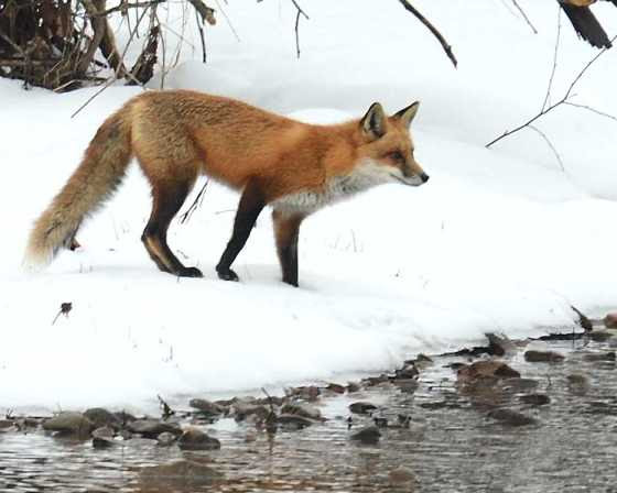
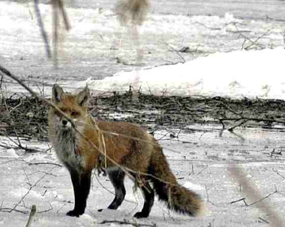
The female red fox hiding behind the branch along the shoreline is a trigger for the behavior that followed and not digitally captured. She looked directly at me while she moved off, and defiantly stopped in the open and still staring back at me, squatted to pee
The current is my guide, as my hull is directed to follow its winding course worn into the hard shale riverbed, especially critical at lower water levels.
Ice out! open water, adventure awaits! Image of me taken without my knowledge, by Bill Haduch. Never know what you might see on the river.
I generally use a hit and switch style of paddling where the boat is kept on course by alternate stokes instead of turning the paddle blade at the end of the stroke, which is grossly inefficient, as it slows hull speed. Though, any paddle stoke in the nick of time is the correct choice.
As I switched sides after each series of strokes, the water dripping off the paddle blade fell on the ash gunnels and instantly froze. Fine drops quickly freeze and after layers of ice accumulate, its collective weight and height above the water, moved the center of gravity forward to make the hull plow left or right with each stroke and reduce stability. An occasional pause was required to clear the gunnels of ice, using the paddle’s sharp edge to shatter the ice.
Clearing the ice was not an existential crisis and at times I would use a north woods style paddle stoke in deep water, where all paddling is done on a chosen side, never lifting the paddle from the water. This is a useful stroke when drifting up on unaware wildlife as paddling motion is restricted to the offside and the stroke, completely silent.
As I neared home pasture, a light but steady snow began to fall straight down. This was the time to allow the river’s energy to take control one last time, set aside my physical presence and exist for a meditative moment in conscious stillness. A brief side trip, compliment of the water’s endless energy.
The carry from the river through the pasture to home had its own reward. I have a pair of pile lined, heavy wool mittens stowed in a zip lock bag, reserved just for this occasion.
I rarely wear gloves when paddling in cold weather, though when I take out, stow my pack and paddles, lift the hull on my shoulders, my hands get wet and cold from the water collected in the hull. It is an anticipated treat to wear those mittens on the portage home. As I slipped on the mittens, I noticed a single flake of snow caught on an errant strand of wool, its unique structure designed as if by intelligent hand. This was the essence of a mid-winter canoe trip, ephemeral moments in nature, stored in memory for instant retrieval, to be enjoyed and shared. It was just the icing on the gunnels.
Author Joe Mish has been running wild in New Jersey since childhood when he found ways to escape his mother’s watchful eyes. He continues to trek the swamps, rivers and thickets seeking to share, with the residents and visitors, all of the state’s natural beauty hidden within full view. To read more of his writing and view more of his gorgeous photographs visit Winter Bear Rising, his wordpress blog. Joe’s series “Nature on the Raritan, Hidden in Plain View” runs monthly as part of the LRWP “Voices of the Watershed” series. Writing and photos used with permission from the author.
Article by Franklin Township resident Anna Merrett, photos by LRWP Board Member Heather Fenyk and NJ Water’s Mitch Mickley. For tools and guidelines for implementing Green Infrastructure and low impact design in your communities, see the Environmental Protection Agency’s Non-Point Source Pollution webpage, which includes the Bioretention Design Handbook, published by their Nonpoint Source Management Branch. The handbook was developed to inform practitioners about the latest approaches and lessons learned for bioretention design, construction, inspection, and operation and maintenance.
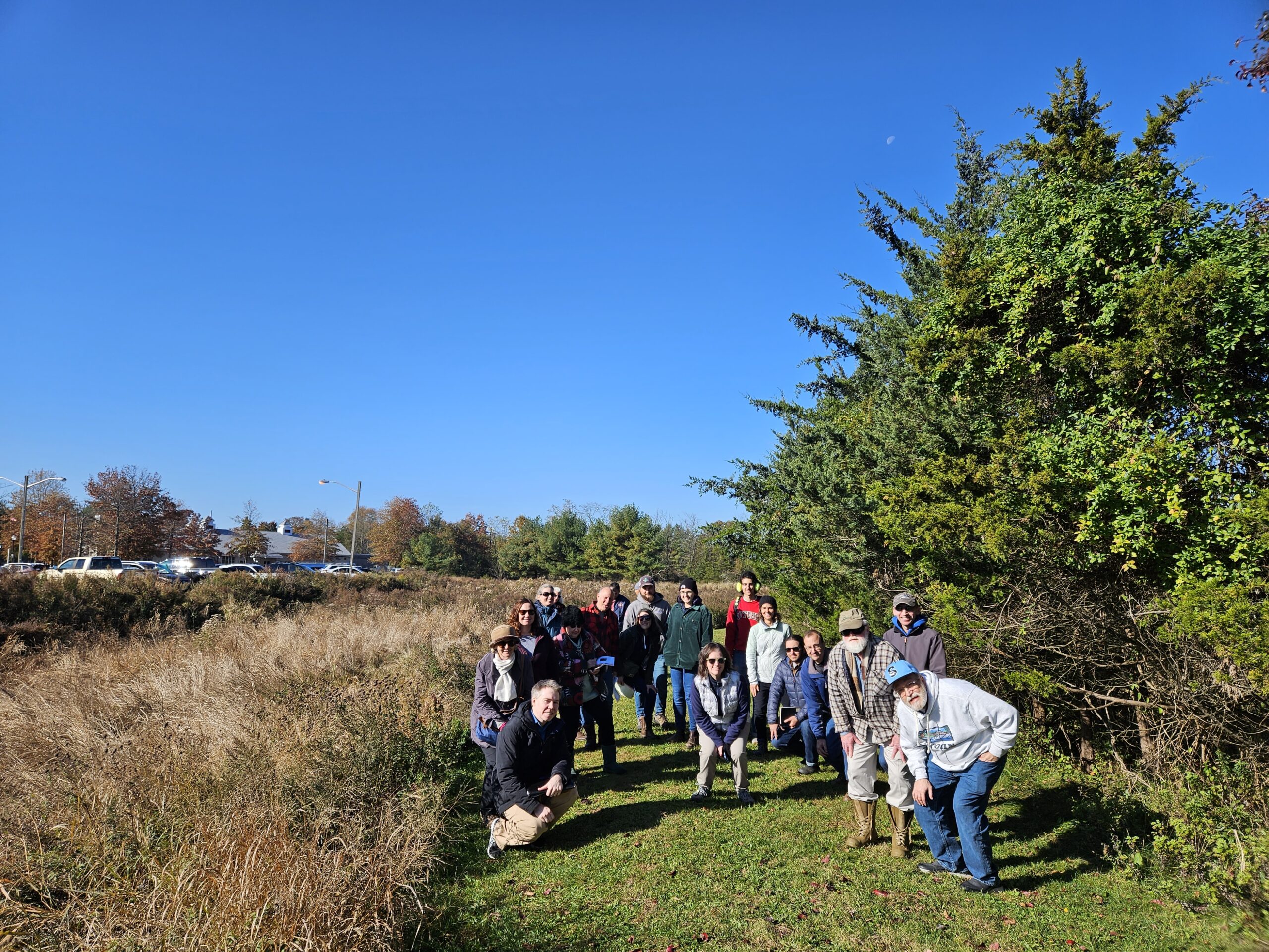
On Friday, November 3rd, Kathy Hale, Principal Watershed Protection Specialist for NJ Water Supply Authority (NJWSA), led a field trip to four out of five retrofitted stormwater basins in Franklin Township, Somerset County. The outing was organized and sponsored by the Lower Raritan Watershed Partnership. Twenty participants, including members of municipalities, representatives from state departments, the Highlands Commission, engineering firms, academia and Environmental Stewards took part in the field trip. A smaller group ended the day with lunch at Stage House Tavern, where lively discussions followed.
Located in the Franklin Township Municipal Complex, on Gaugin Way, Renoir Way, Dellwood Lane and Laird Terrace, the stormwater basins are owned by the Township and mainly receive residential runoff. Franklin Township mapped their stormwater infrastructure ahead of most other municipalities. Township staff worked with NJWSA to select these five basins for retrofit based on size, location, visibility, and structure. The main goal of the retrofits is to slow water runoff and lengthen the water flow path, helping decrease the amount of sediment flowing into the Delaware and Raritan Canal and other local waterways. Increased sediment in stormwater runoff leads to the need for additional treatment by water supply purveyors.
Mitch Mickley, who shared this drone footage, shared that the drone was flown during a drought, and makes the stormwater basin at Renoir Way, Franklin Township (NJ) “look like a green oasis in a sea of dry dead lawns.”
NJWSA’s Kathy Hale explained the background for the basin retrofit in greater detail:
“NJ Water Supply Authority, created in 1981, is an independent state agency. Our main role is to manage water supply in Central New Jersey, so we manage Spruce Run Reservoir, Round Valley Reservoir and the Delaware and Raritan Canal as drinking water supplies that provide water to about 1.5 million people in Central New Jersey. We also manage Manasquan Reservoir, where we provide a supply for around 600,000 service connections in Monmouth County. NJWSA doesn’t treat water, but provides untreated water to the water purveyors, who then treat and distribute it. At Manasquan Reservoir we do have a small water treatment plant which provides water under contract to a few municipalities. Our main role is to maintain the quantity of water that flows to our water purveyors, including: NJ American Water Company, Middlesex Water, North Brunswick, New Brunswick and the municipalities in the Manasquan System. Our customers understand that it is less expensive to keep pollutants out of the water rather than remove them.
The Delaware and Raritan Canal is a 65-mile water supply facility that transfers water from the Delaware Basin to the Raritan Basin. Data and field observations show that turbidity does not decrease in the last 11 miles of the Delaware and Raritan Canal, indicating that settling solids are replaced by sediment from influent streams and stormwater discharges.
Traditional stormwater basins have a concrete low flow channel designed to move water through as fast as possible. Traditional stormwater basins are also typically planted with turf grass, which does not aid water quality treatment or drainage into the ground. Many stormwater basins are fairly compacted when it comes to the soil, which does not help with infiltration. The turf grass tends to encourage nuisance species such as geese and it has high maintenance cost.
We worked with the Township and identified several basins, which we prioritized, and chose four to be retrofitted. A fifth basin was added later in the project. Princeton Hydro provided design services for the project. Three of the basins are within the Cedar Grove Brook watershed, one of the largest drainage areas to the Canal. A fourth basin drains into Six Mile Run and the fifth basin drains into the Canal through another tributary. Funding for the project was provided by NJDEP and the Delaware and Raritan Canal Commission.”
Our group carpooled to the basins, where we walked around the basins, allowing for a closer examination of the retrofits.
Carl Hauck, the Manager of Franklin Township Public Works and the Township Stormwater Coordinator, explained the maintenance plans for the retrofitted basins: The township inspects the basins following every major storm, regularly checks for trash, removes sediment, and mows the basin meadow just once or twice a year. Previously, the basins were mowed every week during the high growth summer months.
Our group poses next to the stormwater basin at the Franklin Township Municipal Building
The new vegetation, consisting of native wildflowers, requires minimal upkeep, significantly lowering the overall maintenance cost, noise levels and energy usage. Planted wildflowers attract birds, pollinators, and other wildlife, and deter the geese. The upgraded vegetation with its deep roots, helps filter out pollutants and lets the stormwater runoff soak gradually and directly into the soil. The concrete channels for water runoff have been replaced by naturally meandering waterways, greatly slowing down the water flow. Berms, forebays and scour holes were built into the inlet structure to further slow down the runoff.
“At each of the basins, the bottoms were rototilled to reduce compaction and the soil was supplemented with compost. Basins are designed to drain within 72 hours, in part to prevent mosquito breeding.” At one of the basins, an underdrain was also added to facilitate water movement.
NJWSA reached out to the five stormwater basins’ neighbors holding zoom meetings and sending postcards explaining the necessity of the retrofit. Some homeowners did not find the look of the retrofitted basins visually appealing, preferring the traditional lawns.
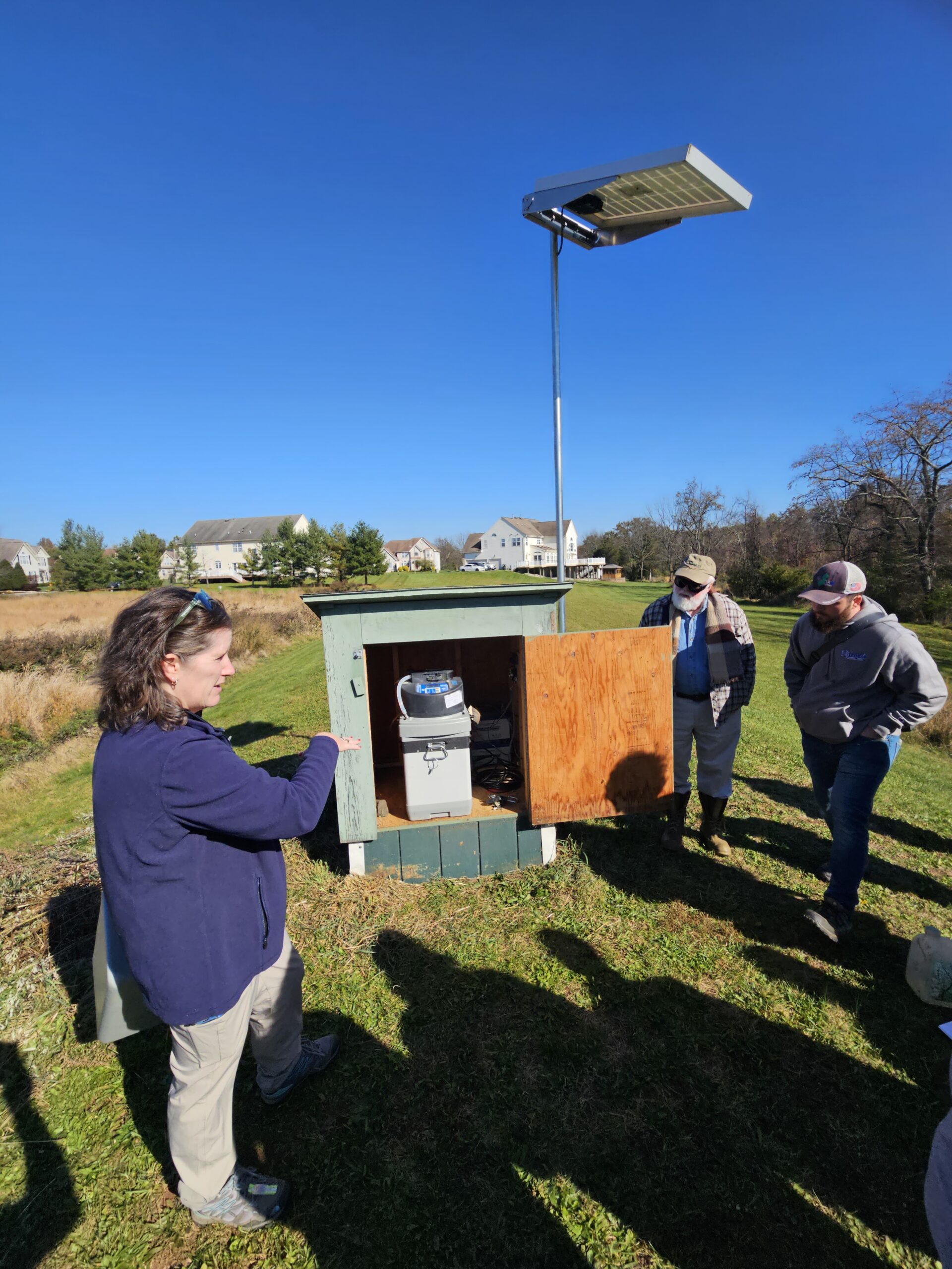
NJWSA has conducted visual and vegetation monitoring. In addition, they are conducting pre and post construction water quality monitoring at two basins.
Kathy Hale explains how water quality samples are captured at this site.
Heather Fenyk notes: “The Lower Raritan Watershed Partnership offers multiple workshops and field trips annually to support municipalities and local community members to better understand local hydrology and best practices for watershed-friendly stormwater management. The November 3rd tour of Franklin Township’s retention basin retrofits was specifically organized as part of the LRWP’s MS4 Municipal Stormwater Management Assistance Program, through which we partner with municipalities to customize watershed-friendly stormwater outreach and education programs to help them meet federally mandated stormwater management requirements under the Clean Water Act. We invited Kathy Hale to share the wonderful work that Franklin Township and the Authority have done locally so that other municipalities in the area could get a soup-to-nuts understanding of what it takes to install these beautiful, watershed-friendly, River-friendly, drinking-water-friendly projects. We would love to see dozens of naturalized stormwater basins throughout the Lower Raritan!”