By LRWP Monitoring Outreach Coordinator Jocelyn Palomino
Every Thursday from May to October, the Lower Raritan Watershed Partnership and Rutgers Cooperative Extension of Middlesex County run a volunteer-based monitoring program along the Raritan River. During the summer, we collect water quality samples at six non-bathing public access beach sites, provide our samples to the Interstate Environmental Commission for analysis in their laboratory and report the results to the public on Friday afternoons. Our mission is to share this data with the community and partners to ensure the safe use of the Raritan river for all.
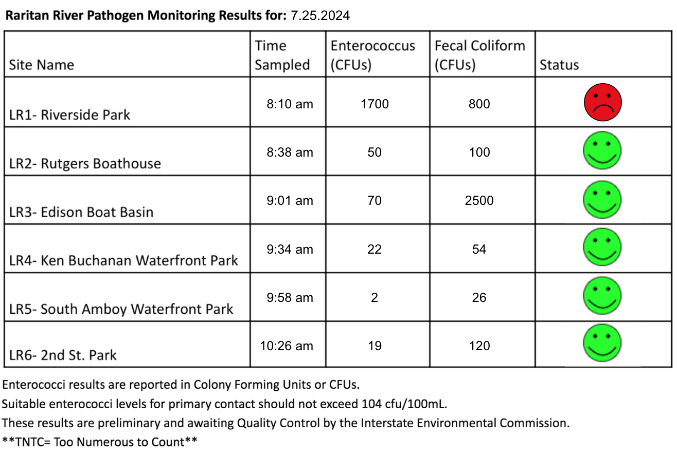
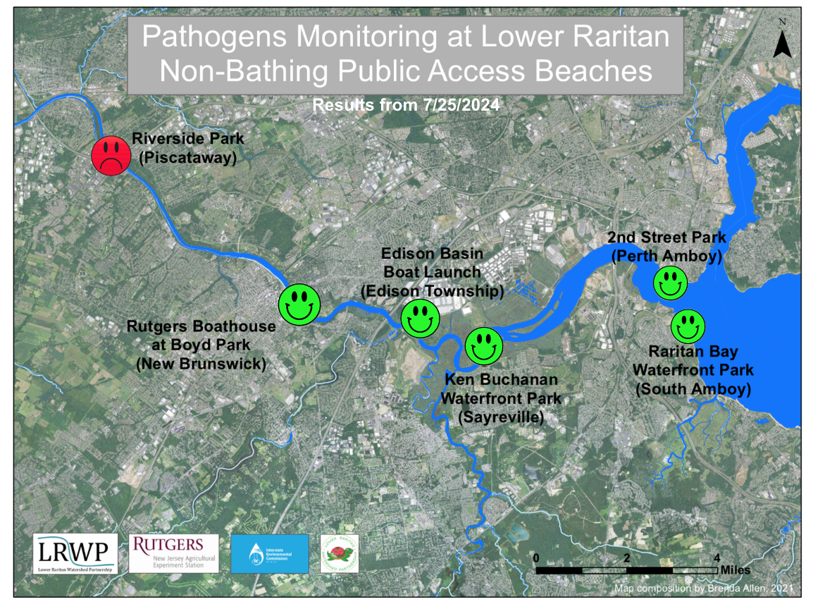
Our lab results for water quality samples taken on Thursday July 25, 2024 show Enterococcus bacteria levels exceeding the EPA federal water quality standard of 104 cfu/100mL at only ONE of our monitoring sites this week. Problem sites are indicated by red frowns on the map and chart which includes: Riverside Park (Piscataway). Green smiles on the chart and map indicate the sites with bacteria levels safe for recreation, and include the following: Rutgers Boathouse (New Brunswick), Edison Boat Basin and Ken Buchanan Waterfront Park (Edison), South Amboy Waterfront Park (South Amboy) and 2nd Street Park (Perth Amboy).
Pathogens/Enterococci levels are used as indicators of the possible presence of disease-causing bacteriain recreational waters. Such pathogens may pose health risks to people coming in primary contact with the water (touching) through recreational activities like fishing, kayaking or swimming in a water body. Possible sources of bacteria include Combined Sewer Overflows (CSOs), improperly functioning wastewater treatment plants, stormwater runoff, leaking septic systems, animal carcasses, and runoff from manure storage areas.
Our goal in reporting these results is to give residents a better understanding of the potential health risks related to primary contact during water-based recreation. If you are planning on recreating on the Raritan this weekend, stay safe by properly washing up after any activities!
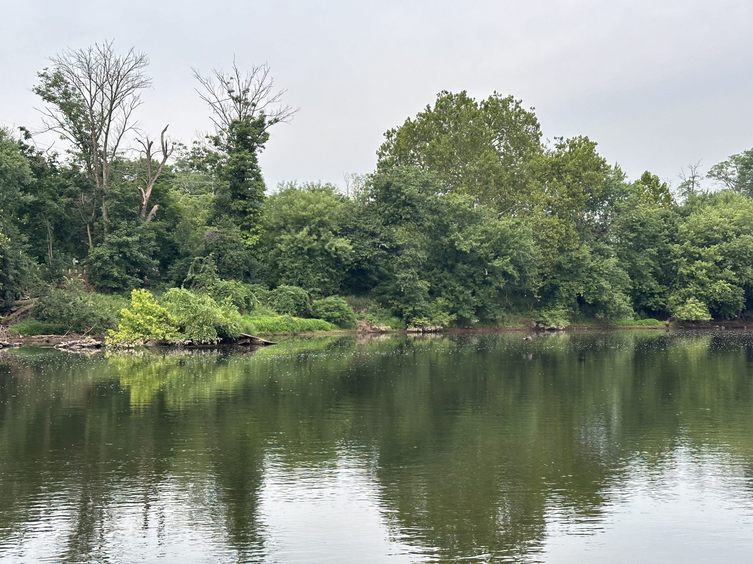
Turbid and scummy waters at LR1- Riverside Park this Thursday morning, pathogen results showed high Enterococcus levels only for this site. Photo Credit: Jocelyn Palomino
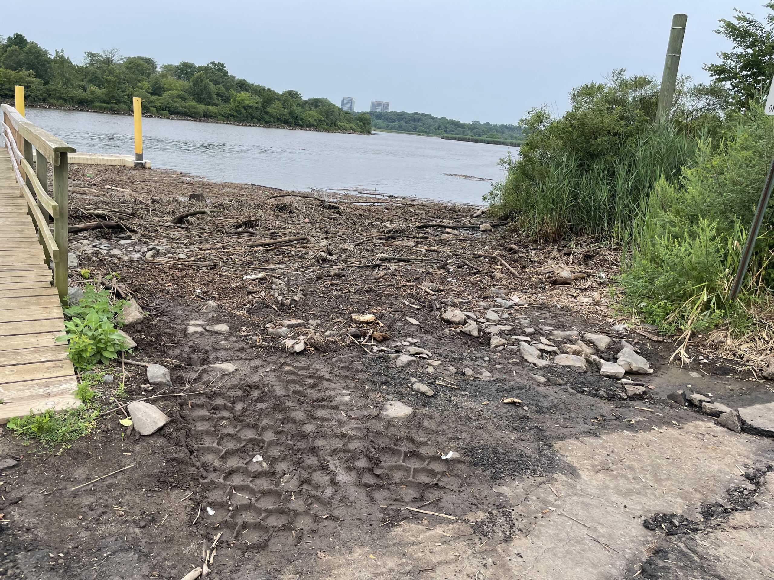
A tremendous amount of debris washed up at the Edison boat launch, Photo Credit: Frank Dahl
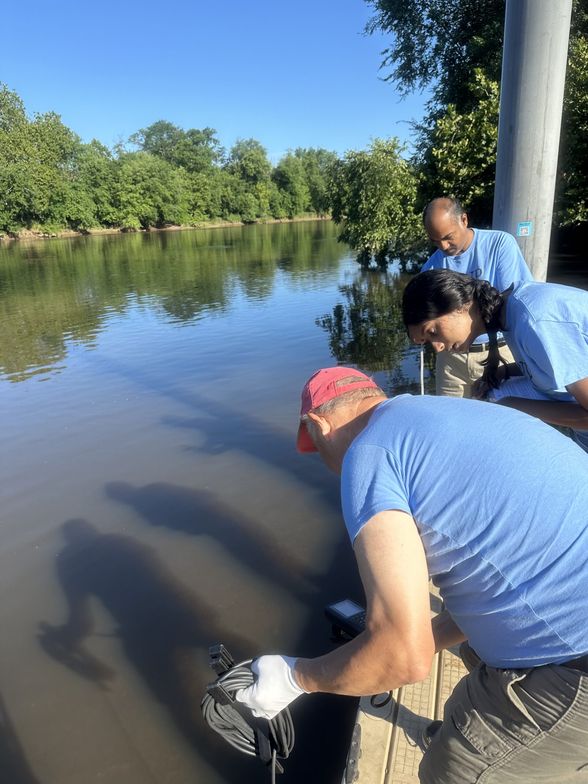
SEWA volunteers have worked closely with the LRWP over the last couple weeks on the Pathogens Monitoring Team, they are becoming excellent water quality professionals!Photo Credit: Jocelyn Palomino
Overcast and gloomy skies on Thursday morning, however, no precipitation was recorded 24 to 48 hours prior to monitoring. Photo Credit: Jocelyn Palomino
Special thanks to our monitoring team of volunteers who joined us this week: Frank Dahl, Thulasi Nambiar, Sanil Nambiar and Nibav Velan!Photo Credit: Jocelyn Palomino
By LRWP Monitoring Outreach Coordinator Jocelyn Palomino
Every Thursday from May to October, the Lower Raritan Watershed Partnership and Rutgers Cooperative Extension of Middlesex County run a volunteer-based monitoring program along the Raritan River. During the summer, we collect water quality samples at six non-bathing public access beach sites, provide our samples to the Interstate Environmental Commission for analysis in their laboratory and report the results to the public on Friday afternoons. Our mission is to share this data with the community and partners to ensure the safe use of the Raritan river for all.
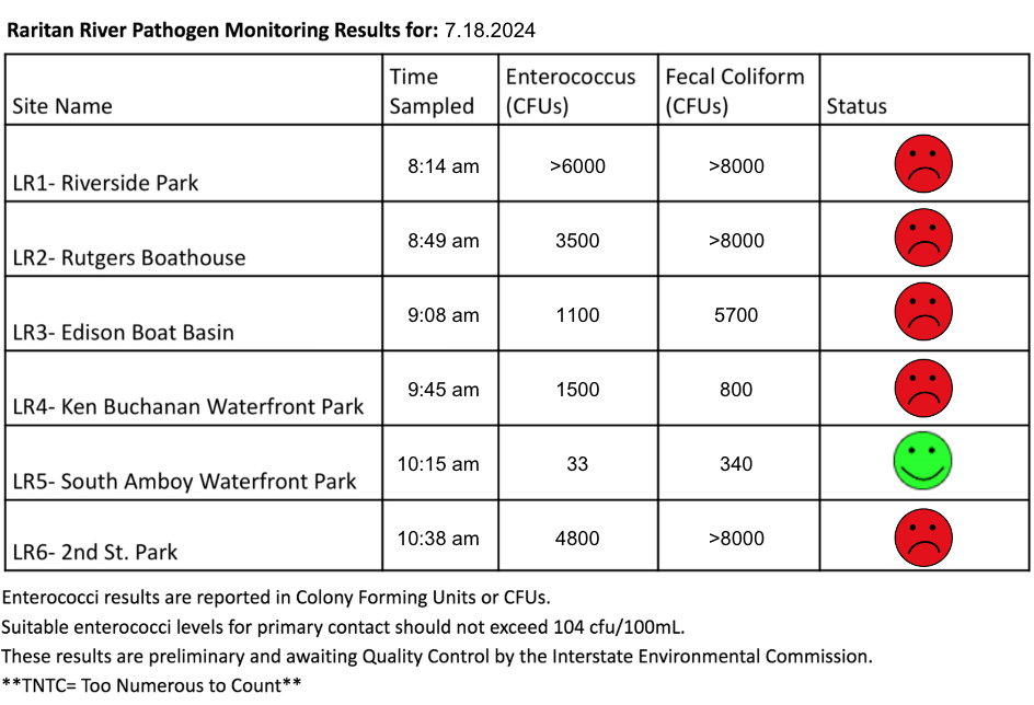
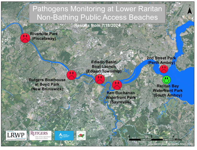
After multiple days of precipitation and thunderstorms, our lab results for water quality samples taken on Thursday July 18, 2024 show Enterococcus bacteria levels exceeding the EPA federal water quality standard of 104 cfu/100mL at FIVE of our monitoring sites this week. Problem sites are indicated by red frowns on the map and chart which includes: Riverside Park (Piscataway), Rutgers Boathouse (New Brunswick), Edison Boat Basin and Ken Buchanan Waterfront Park (Edison), and 2nd Street Park (Perth Amboy). Green smiles on the chart and map indicate the sites with bacteria levels safe for recreation, and include the following: South Amboy Waterfront Park (South Amboy).
Pathogens/Enterococci levels are used as indicators of the possible presence of disease-causing bacteriain recreational waters. Such pathogens may pose health risks to people coming in primary contact with the water (touching) through recreational activities like fishing, kayaking or swimming in a water body. Possible sources of bacteria include Combined Sewer Overflows (CSOs), improperly functioning wastewater treatment plants, stormwater runoff, leaking septic systems, animal carcasses, and runoff from manure storage areas.
Our goal in reporting these results is to give residents a better understanding of the potential health risks related to primary contact during water-based recreation. If you are planning on recreating on the Raritan this weekend, stay safe by properly washing up after any activities!
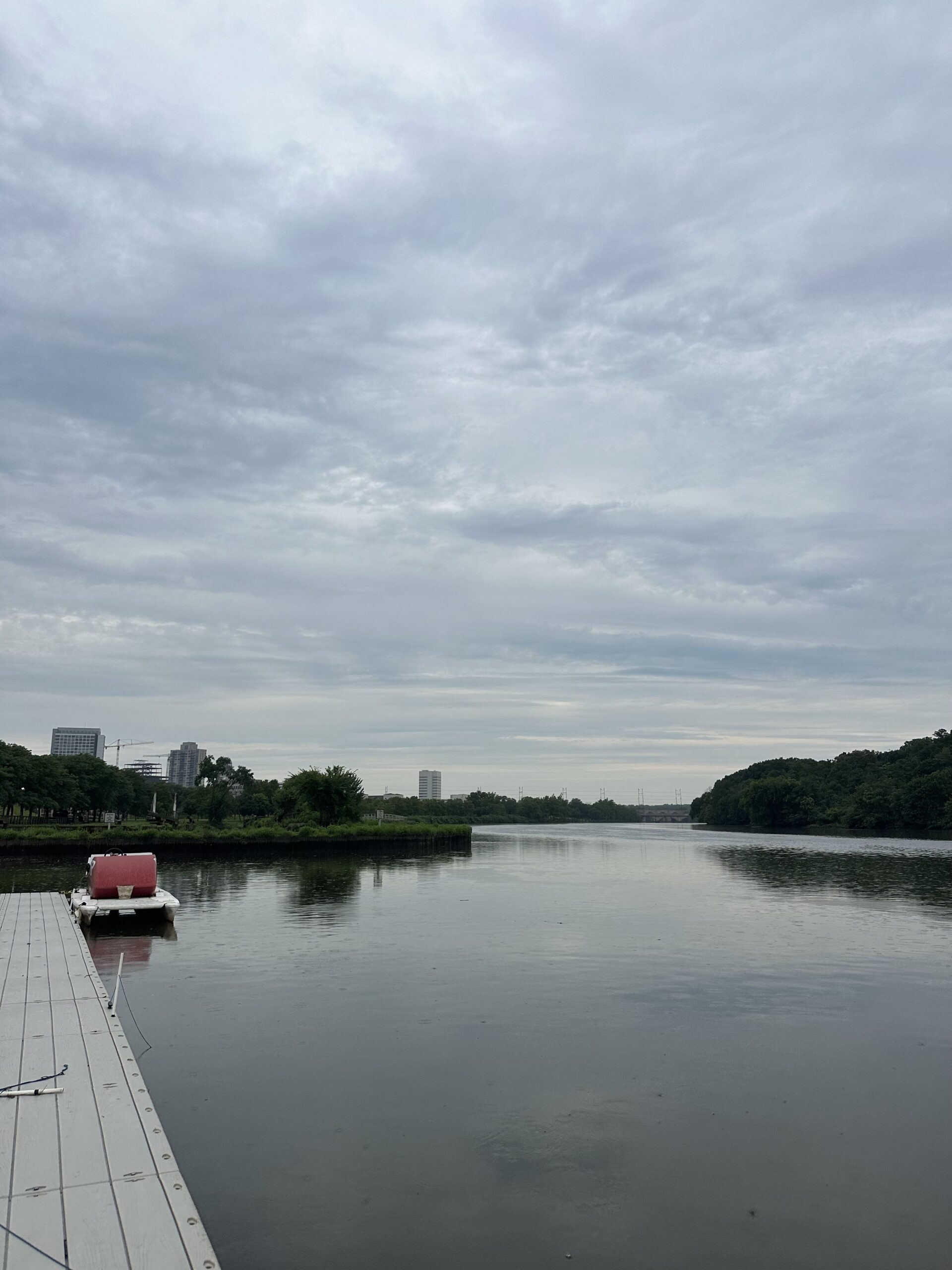
Cloudy skies and light rain over the Rutgers boat docks during our monitoring session this week, Photo Credit: Jocelyn Palomino
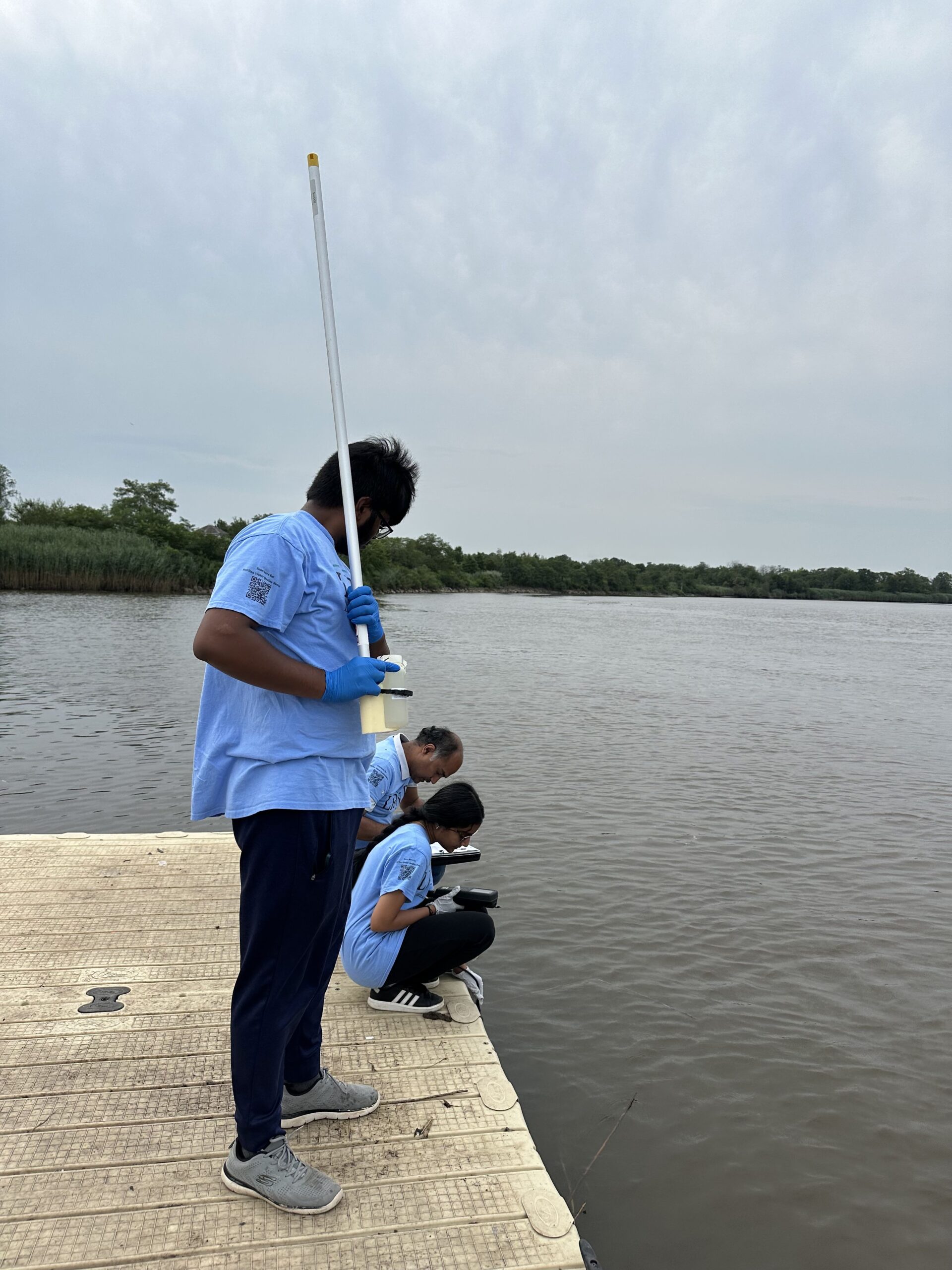
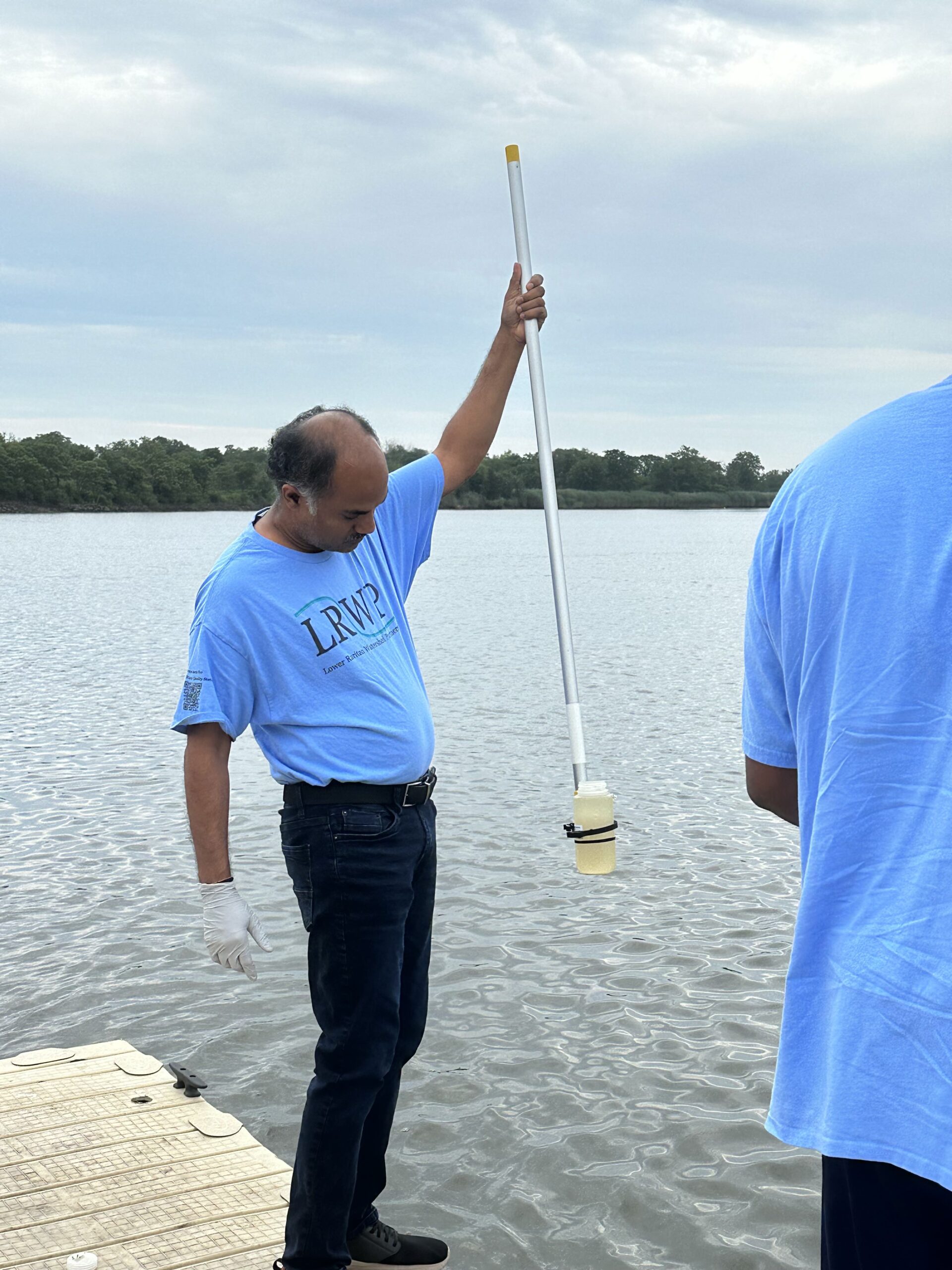
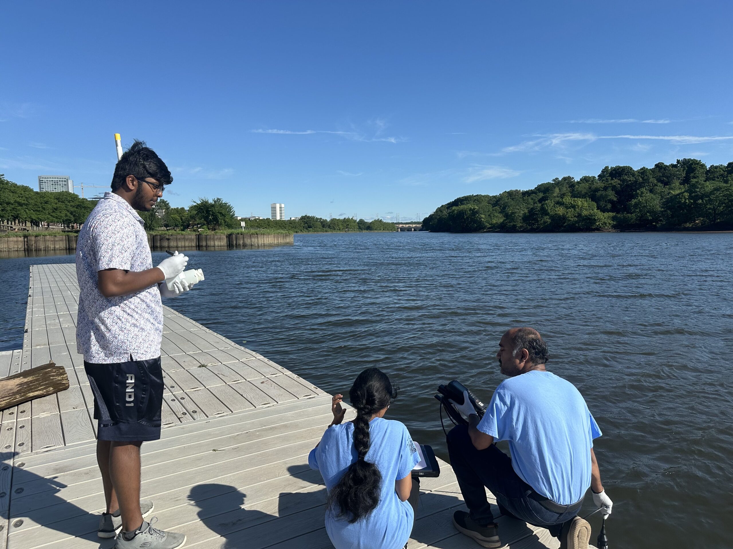
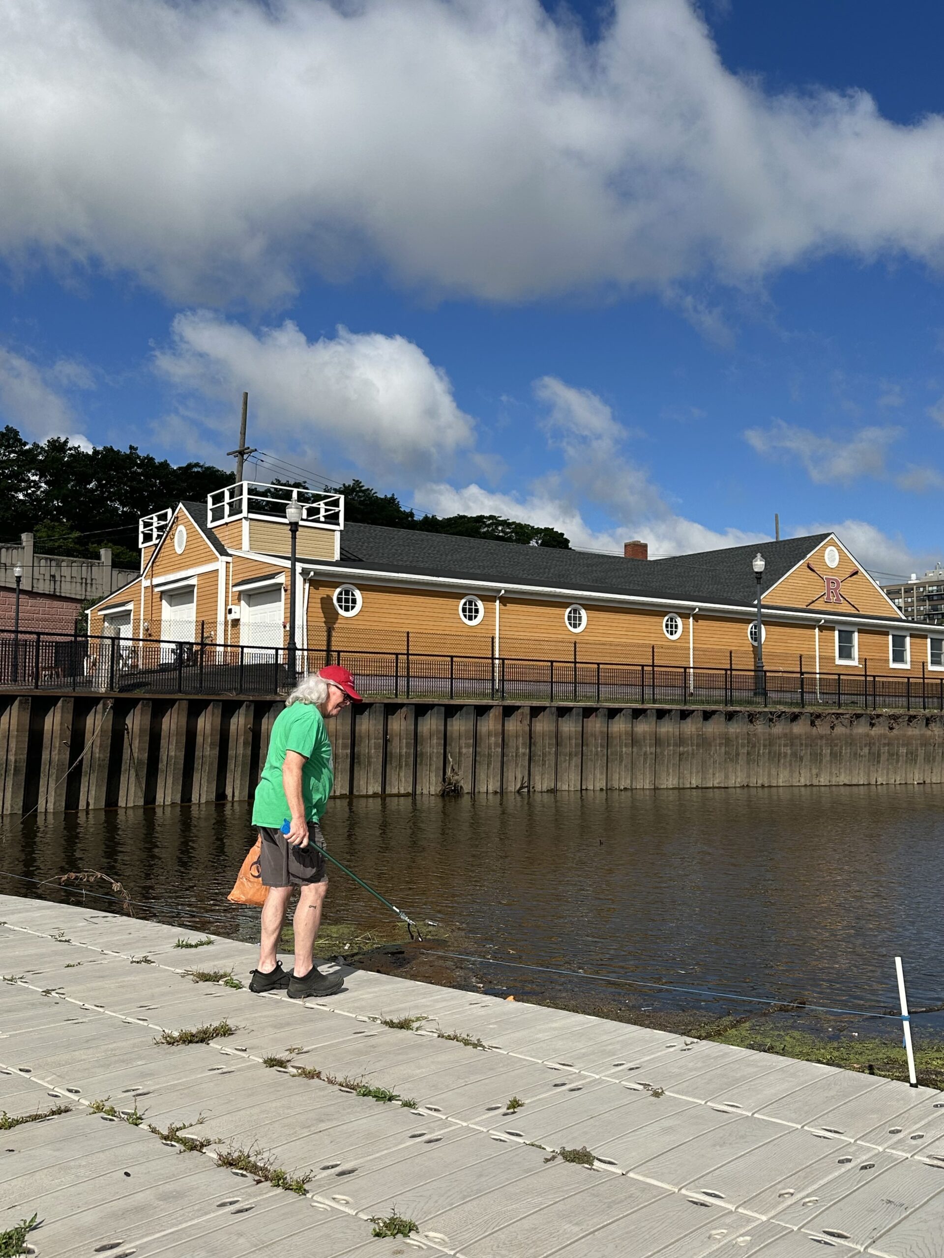
Sanil Nambiar collected our samples for the week with our new and improved sampling stick that we use to retrieve our bottles, Photo Credit: Jocelyn Palomino
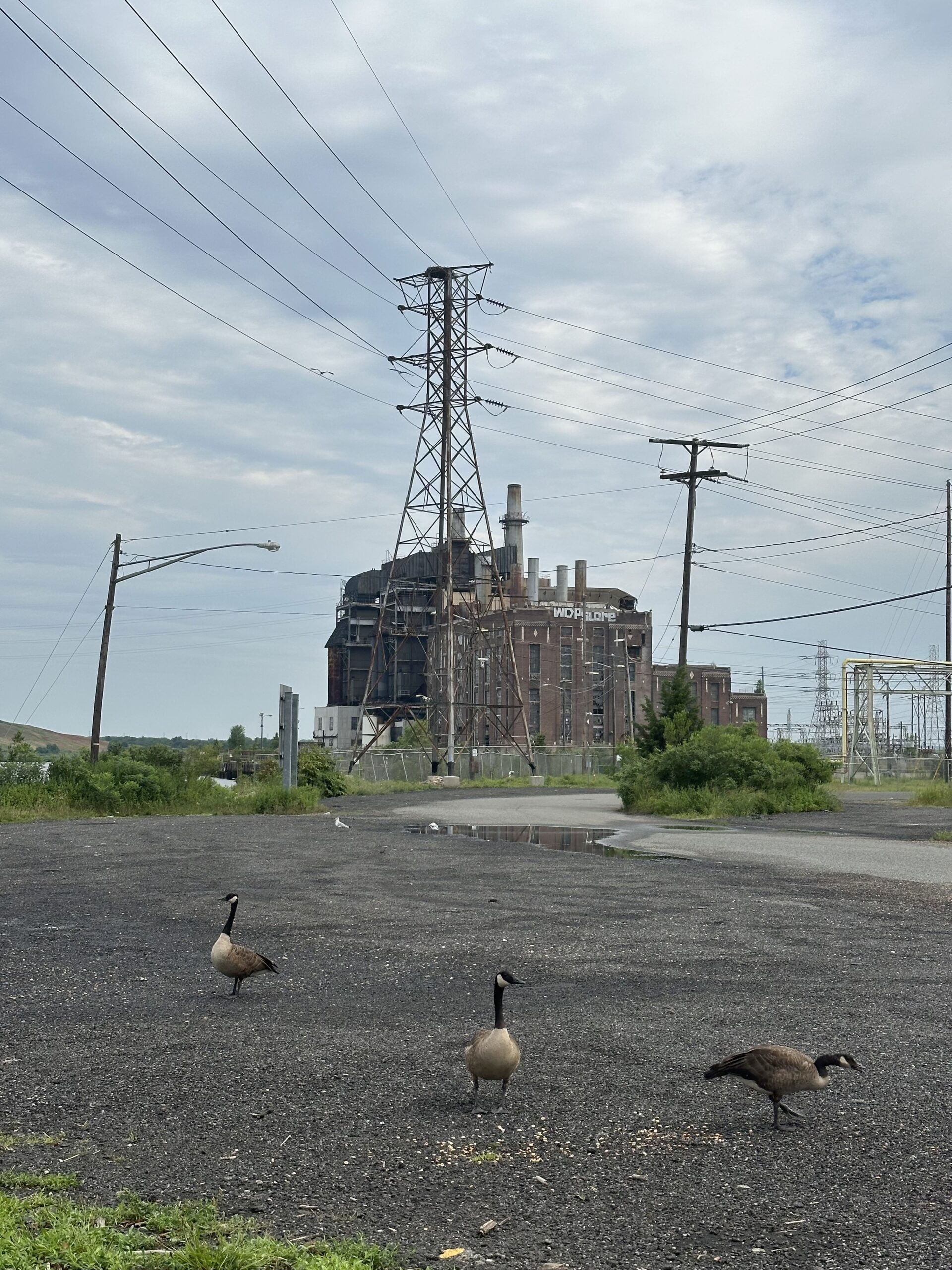
Canadian geese were present at all of our monitoring sites Thursday morning, which was noted in our visual habitat assessment as it may have contributed to some of the fecal matter in our samples, Photo Credit: Jocelyn Palomino
With such heavy precipitation on Wednesday night, the stormwater runoff left trails on the sand of its path leading right into the water at LR5 and LR6, Photo Credit: Jocelyn Palomino
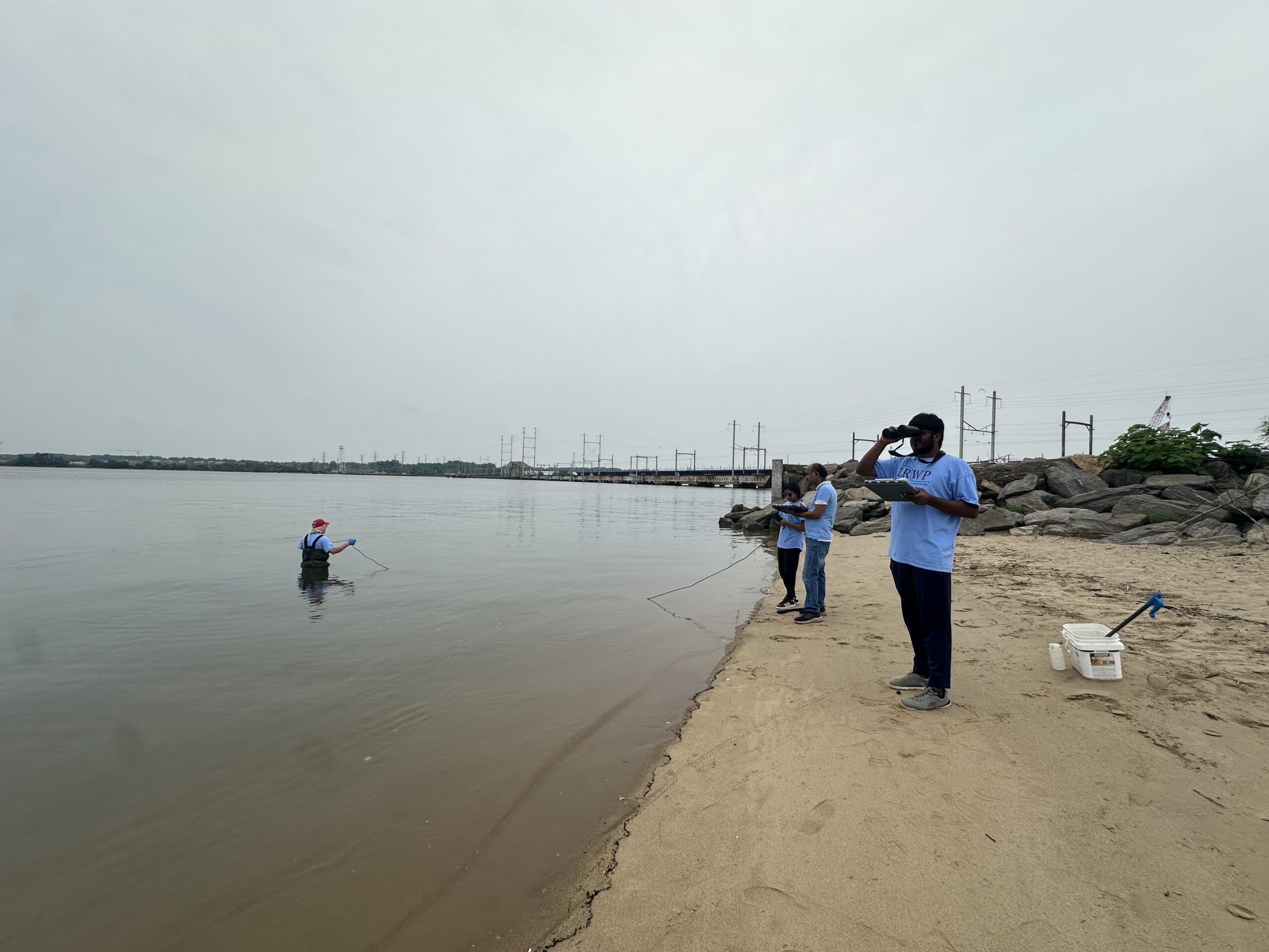
Nibav helping Thulasi gear up before wading into our last site of the day, Perth Amboy’s 2nd. Street Park! Photo Credit: Jocelyn Palomino
By LRWP Monitoring Outreach Coordinator Jocelyn Palomino
Every Thursday from May to October, the Lower Raritan Watershed Partnership and Rutgers Cooperative Extension of Middlesex County run a volunteer-based monitoring program along the Raritan River. During the summer, we collect water quality samples at six non-bathing public access beach sites, provide our samples to the Interstate Environmental Commission for analysis in their laboratory and report the results to the public on Friday afternoons. Our mission is to share this data with the community and partners to ensure the safe use of the Raritan river for all.
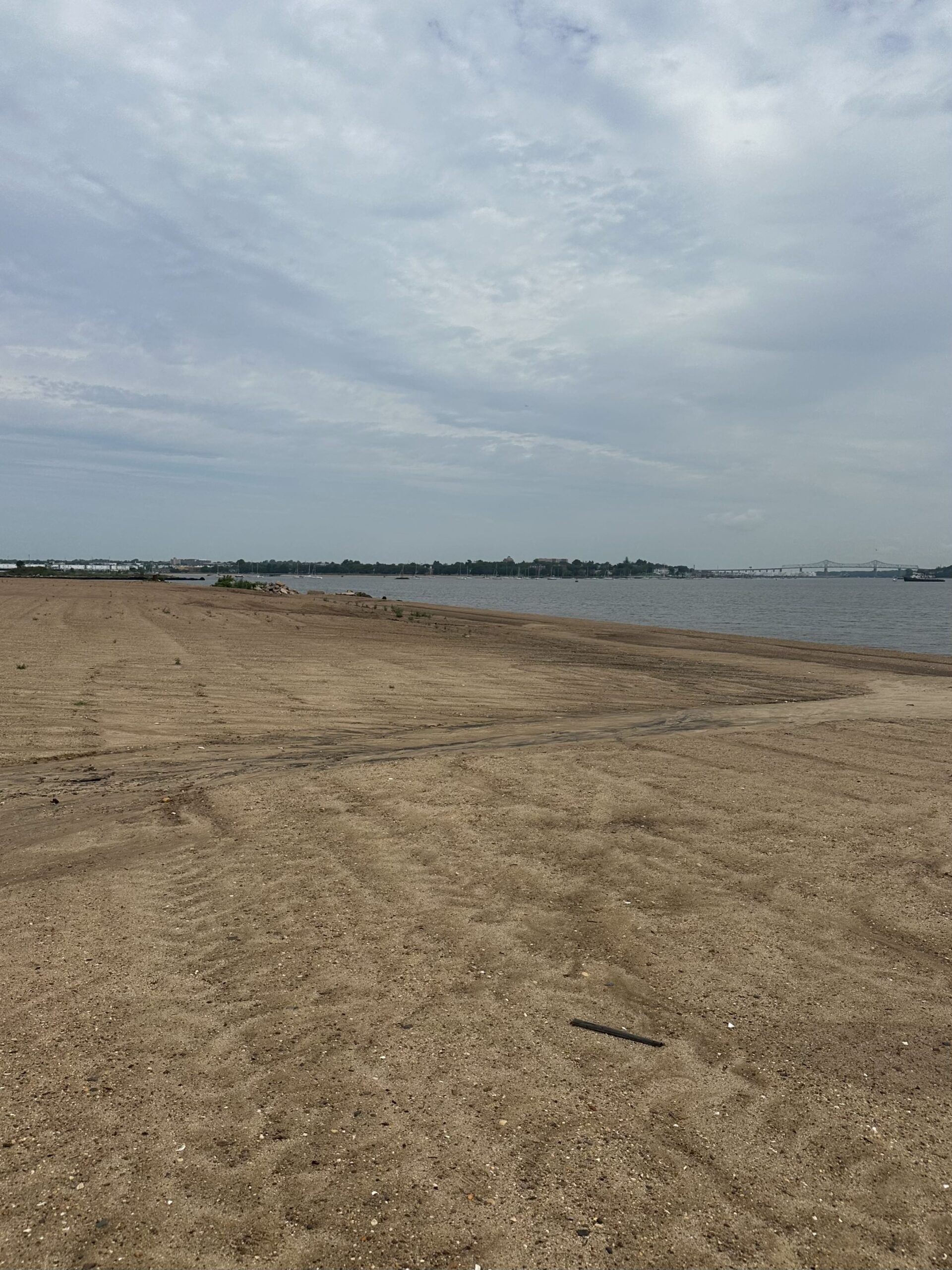
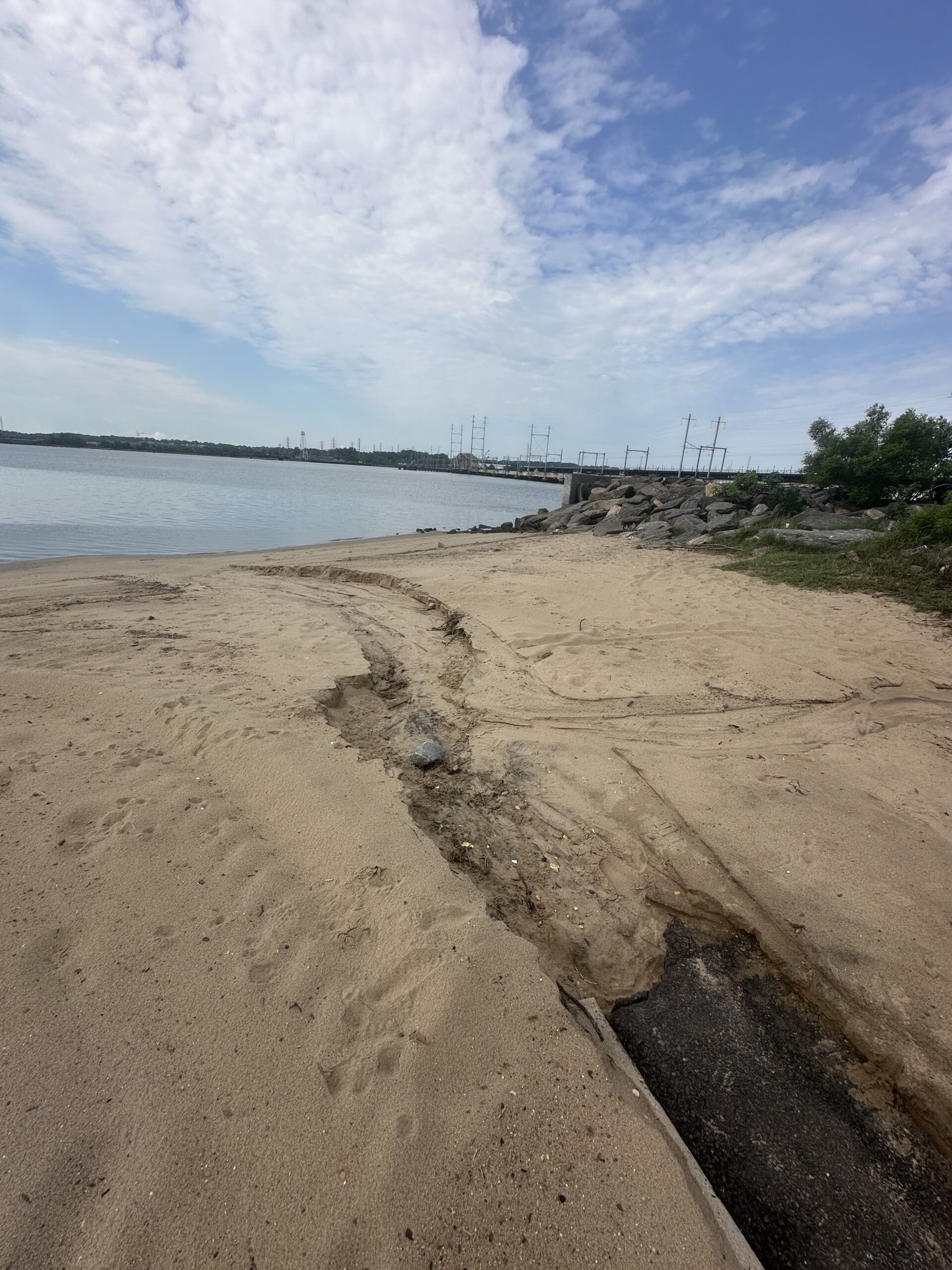
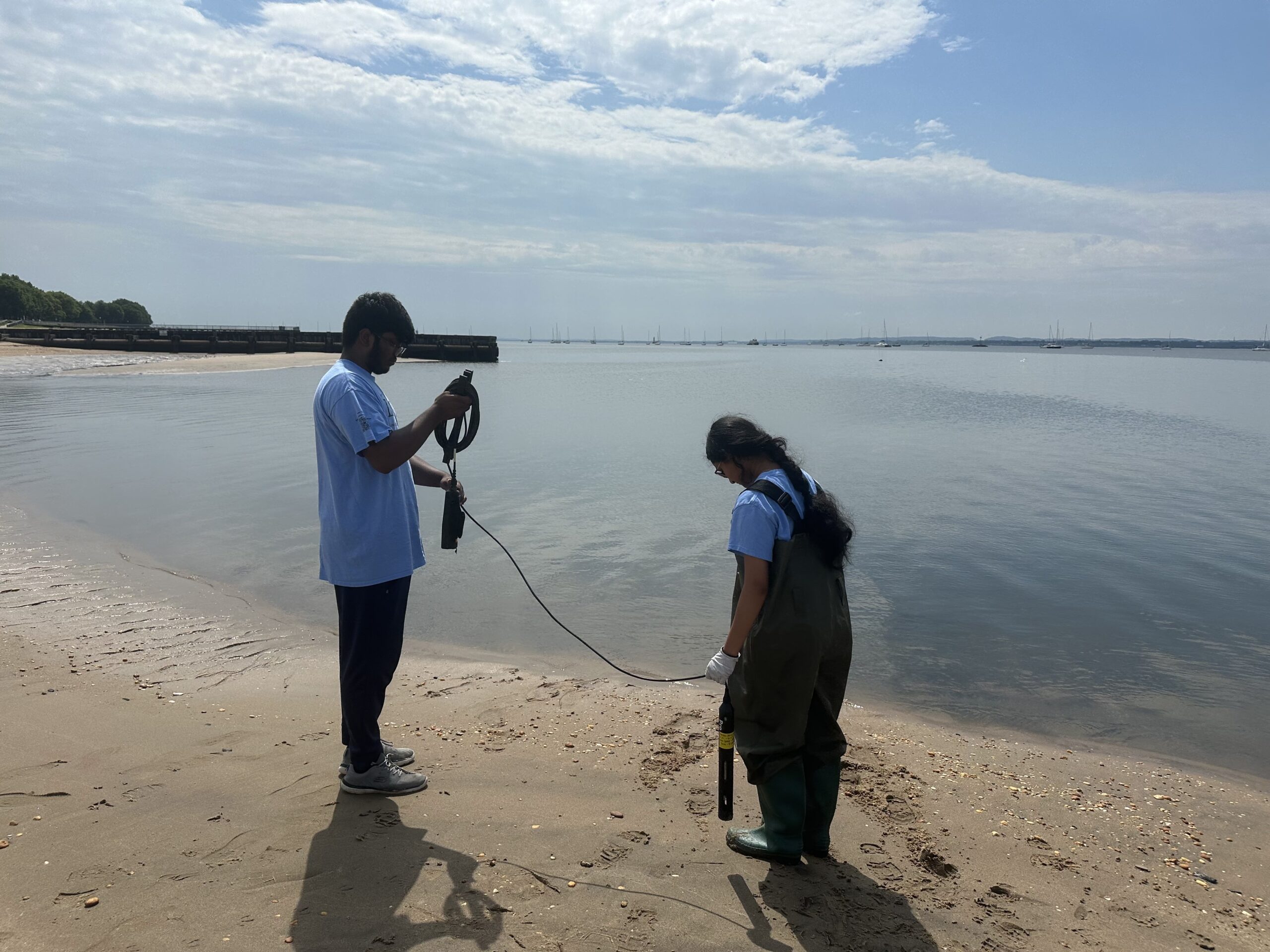
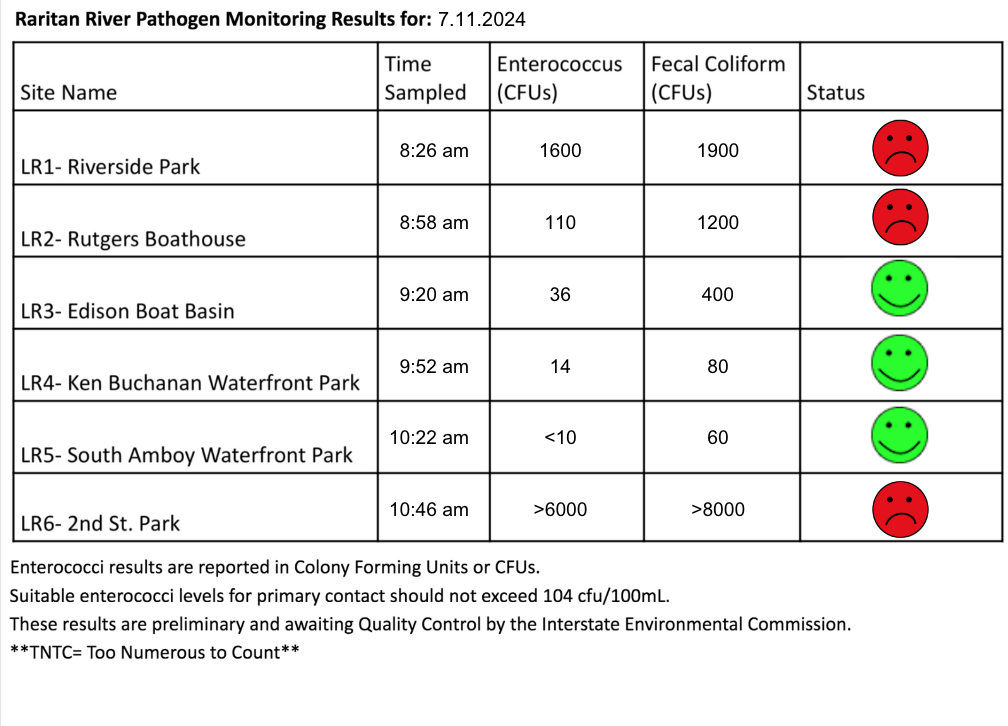
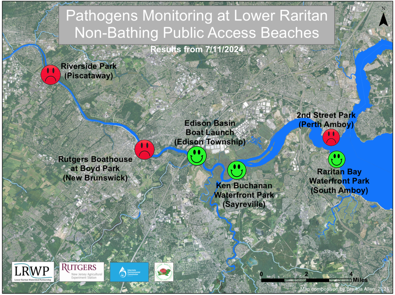
Our lab results for water quality samples taken on Thursday July 11, 2024 show Enterococcus bacteria levels exceeding the EPA federal water quality standard of 104 cfu/100mL at THREE of our monitoring sites this week. Problem sites are indicated by red frowns on the map and chart which includes: Riverside Park (Piscataway), Rutgers Boathouse (New Brunswick), and 2nd Street Park (Perth Amboy). Green smiles on the chart and map indicate the sites with bacteria levels safe for recreation, and include the following: Edison Boat Basin, Ken Buchanan Waterfront Park (Edison) and the South Amboy Waterfront Park (South Amboy).
Pathogens/Enterococci levels are used as indicators of the possible presence of disease-causing bacteriain recreational waters. Such pathogens may pose health risks to people coming in primary contact with the water (touching) through recreational activities like fishing, kayaking or swimming in a water body. Possible sources of bacteria include Combined Sewer Overflows (CSOs), improperly functioning wastewater treatment plants, stormwater runoff, leaking septic systems, animal carcasses, and runoff from manure storage areas.
Our goal in reporting these results is to give residents a better understanding of the potential health risks related to primary contact during water-based recreation. If you are planning on recreating on the Raritan this weekend, make sure to stay safe and wash up after any activities!
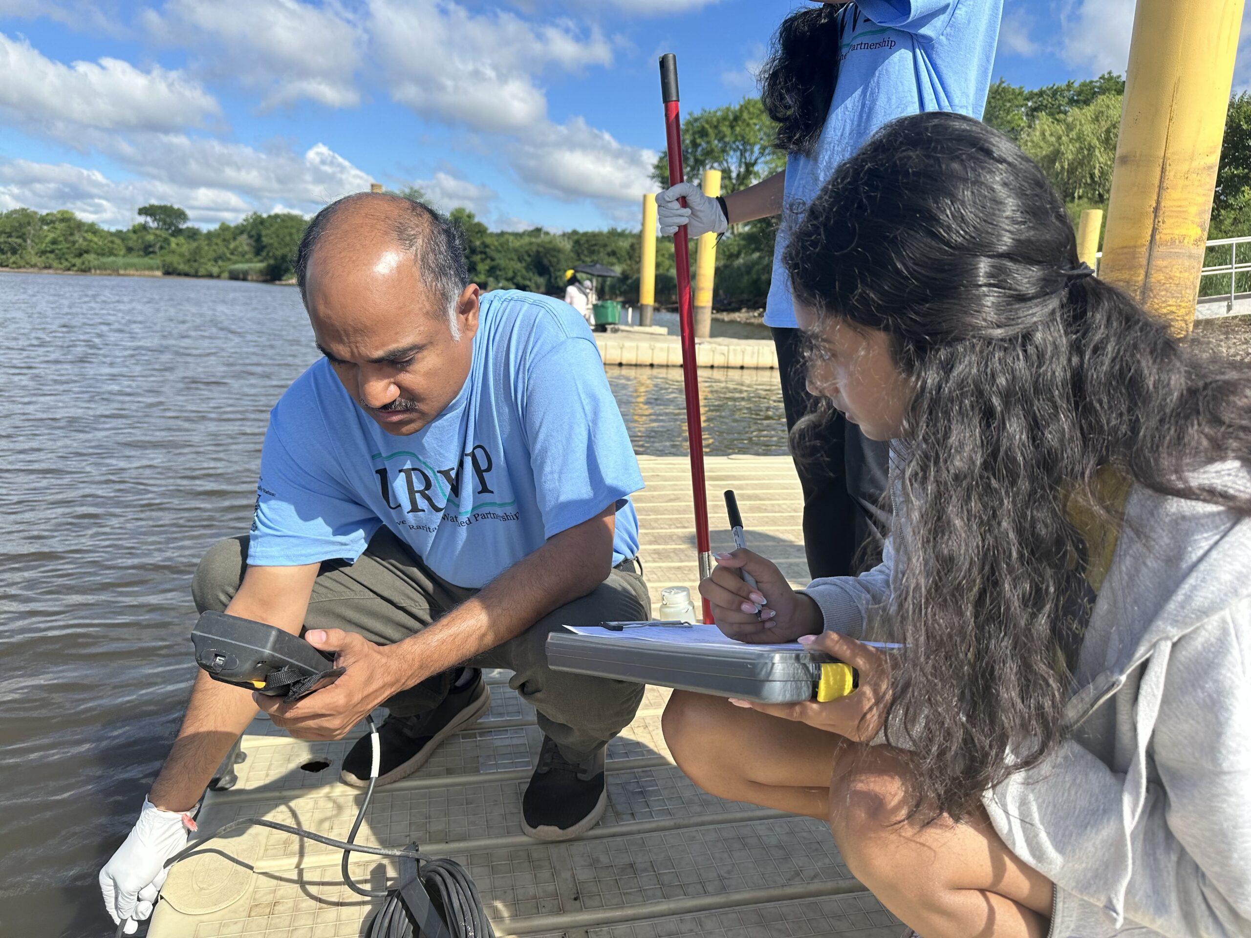
VolunteersNibav, Thulasi and Sanil collecting data from each other while on the docks at the Rutgers Boathouse, Photo Credit: Jocelyn Palomino
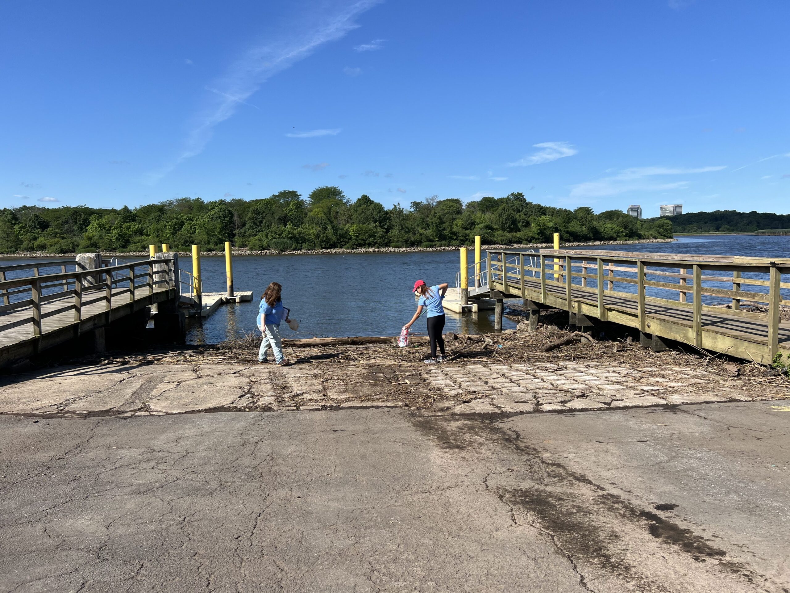
Before heading to the next site, Sofi and Jocelyn picked-up trash that had been washed up at the Edison Boat Basin, Photo Credit: Sanil Nambiar
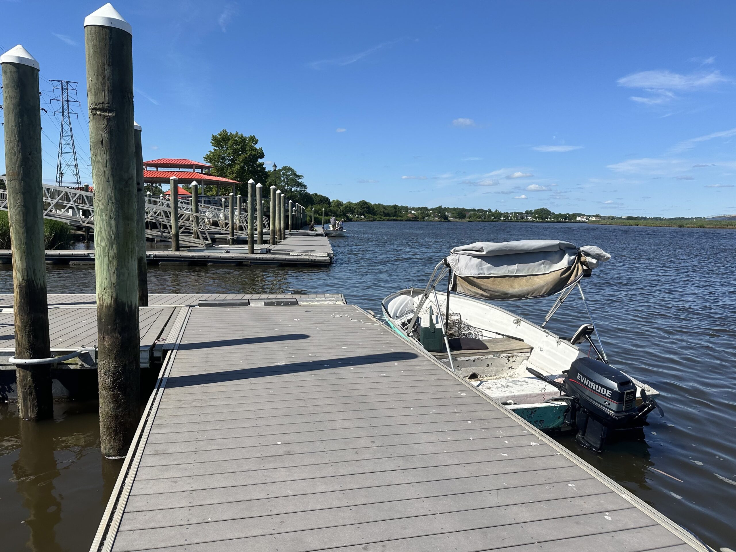
Plenty of boating activity at our monitoring sites along the Raritan this Thursday, please be sure to properly wash-up after all water-related activities for safety! Photo Credit: Jocelyn Palomino
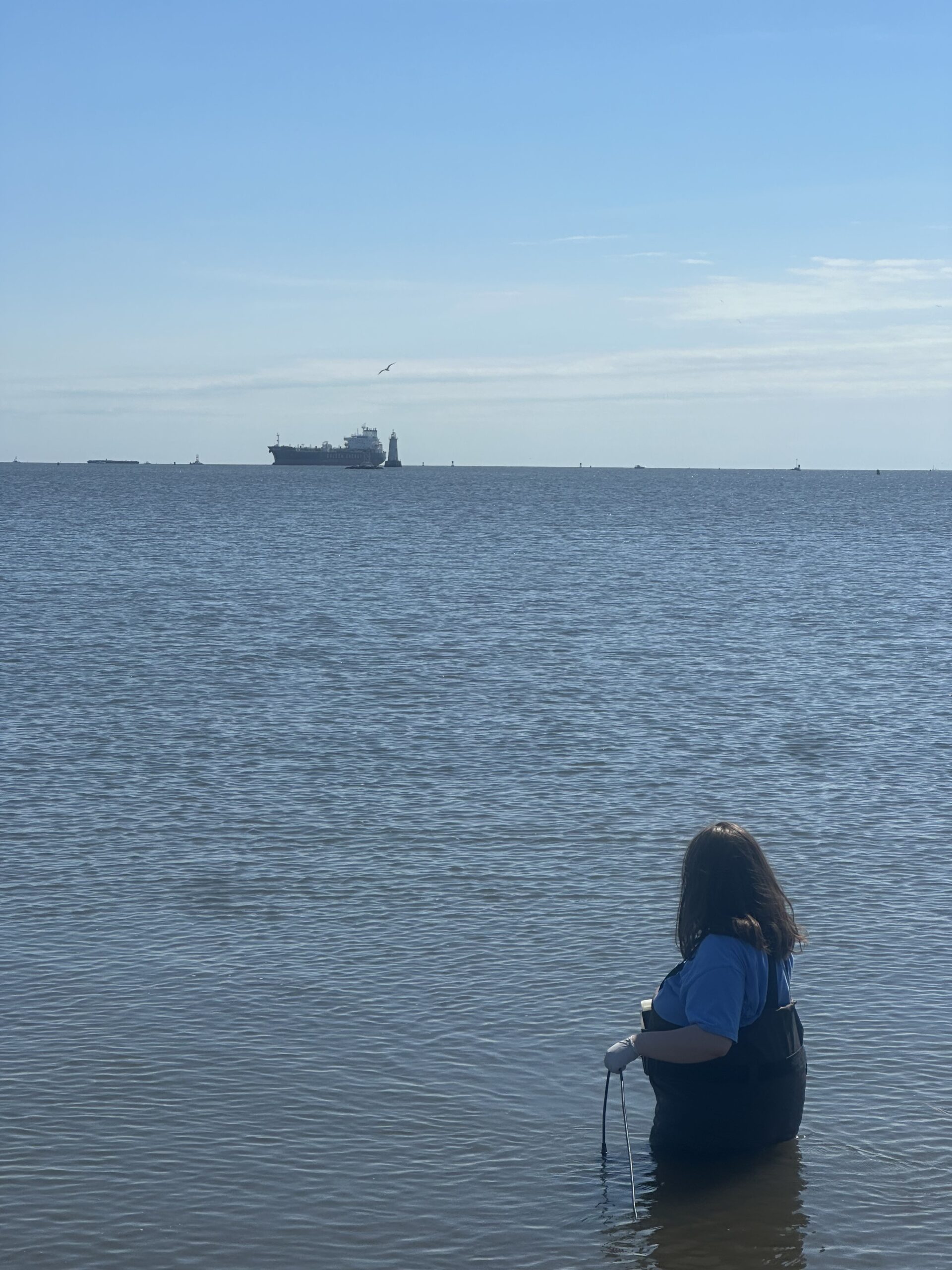
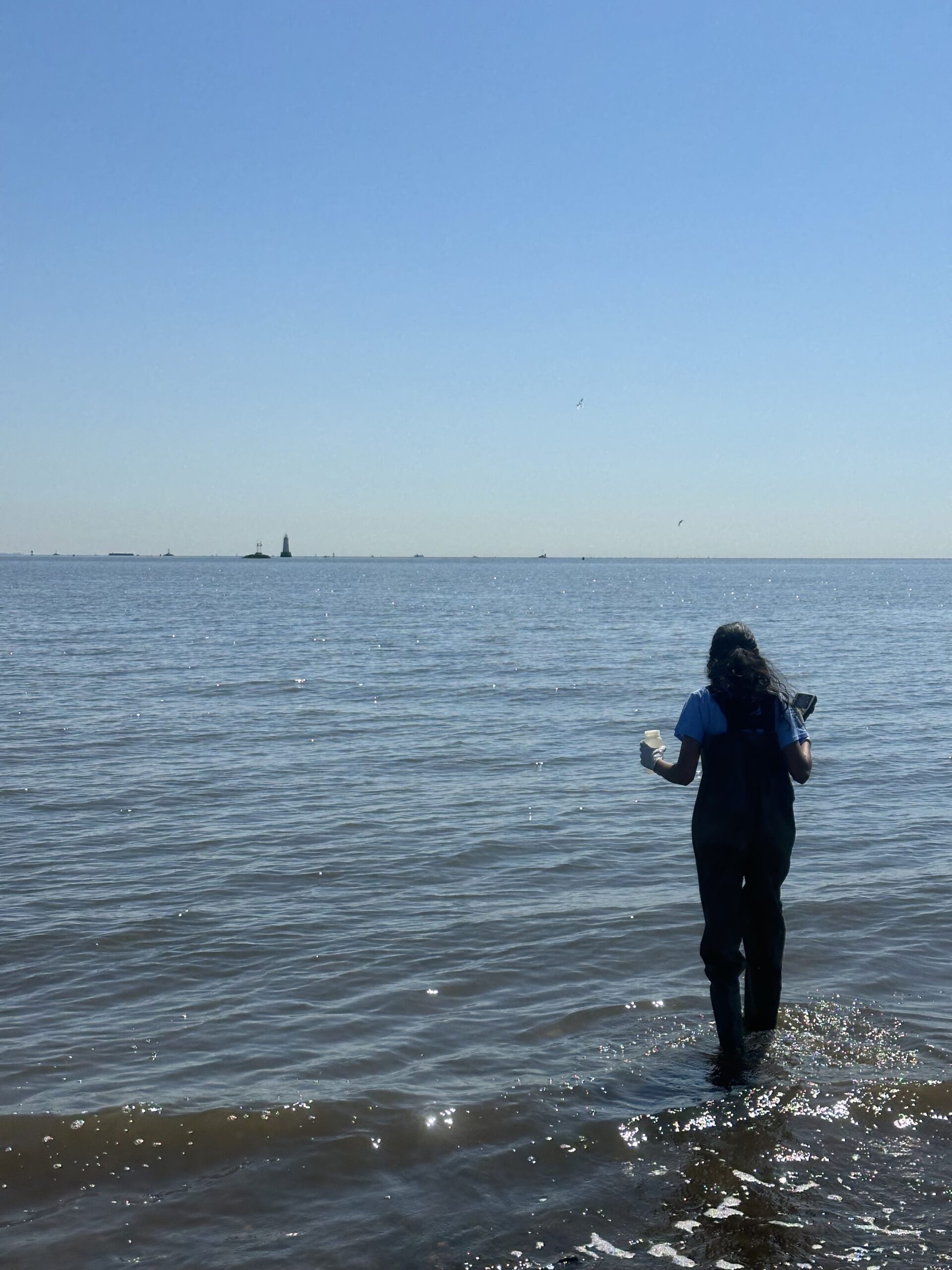
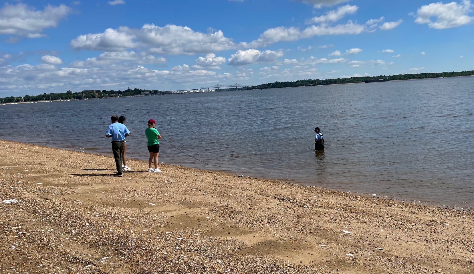
While at the South Amboy Waterfront, we observed a large cargo ship out in the distance right behind the lighthouse- Sofi was able to get a pretty good view since she volunteered to wade in. Looking good out there Sofi! Photo Credit: Jocelyn Palomino
MANY THANKS to the volunteers who joined us this week: Nibav Velan, Thulasi Nambiar, Sanil Nambiar, and Sofi Grossman! Photo Credit: Jocelyn Palomino
By LRWP Monitoring Outreach Coordinator Jocelyn Palomino
Every Thursday from May to October, the Lower Raritan Watershed Partnership and Rutgers Cooperative Extension of Middlesex County run a volunteer-based monitoring program along the Raritan River. During the summer, we collect water quality samples at six non-bathing public access beach sites, provide our samples to the Interstate Environmental Commission for analysis in their laboratory and report the results to the public on Friday afternoons. Our mission is to share this data with the community and partners to ensure the safe use of the Raritan river for all.
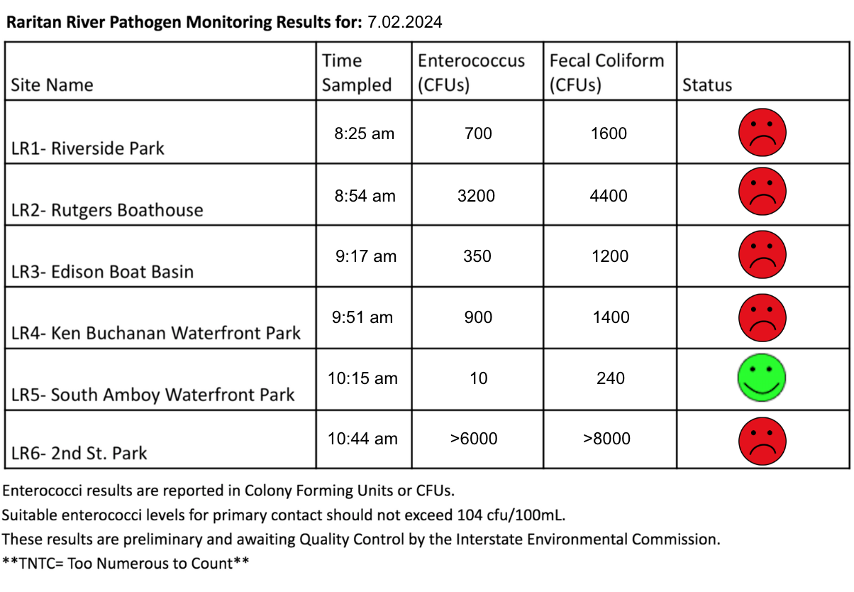
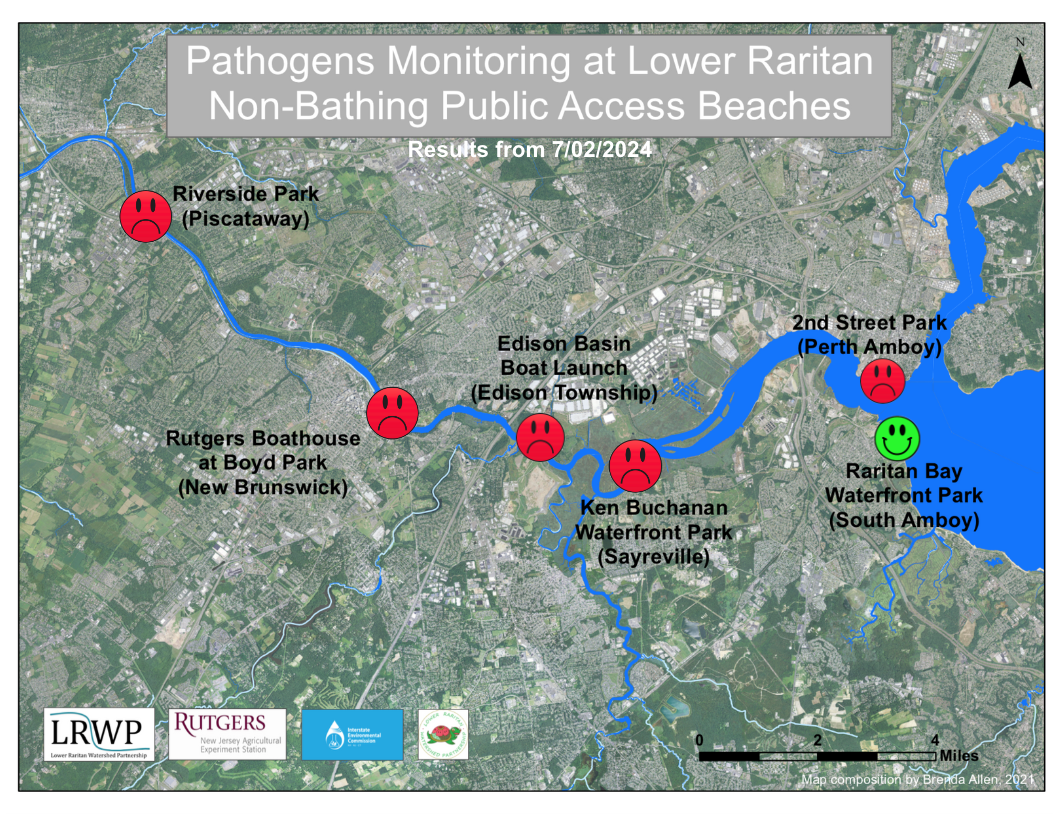
In anticipation of the upcoming holiday this Thursday, the LRWP Pathogens Monitoring team collected samples on TUESDAY July 2, 2024. Our samples taken show Enterococcus bacteria levels exceeding the EPA federal water quality standard of 104 cfu/100mL at FIVE of our monitoring sites this week. Problem sites are indicated by red frowns on the map and chart which includes: Riverside Park (Piscataway), Rutgers Boathouse (New Brunswick) , Edison Boat Basin and Ken Buchanan Waterfront Park (Sayreville), and 2nd Street Park (Perth Amboy). Green smiles on the chart and map indicate the sites with bacteria levels safe for recreation, and include the following: South Amboy Waterfront Park (South Amboy).
Pathogens/Enterococci levels are used as indicators of the possible presence of disease-causing bacteriain recreational waters. Such pathogens may pose health risks to people coming in primary contact with the water (touching) through recreational activities like fishing, kayaking or swimming in a water body. If your plans for the 4th of July holiday include recreation on the Raritan, please keep these results in mind and be sure to clean up properly after all water-related activities.
Our goal in reporting these results is to give residents a better understanding of the potential health risks related to primary contact while recreating on the river. Possible sources of bacteria include Combined Sewer Overflows (CSOs), improperly functioning wastewater treatment plants, stormwater runoff, leaking septic systems, animal carcasses, and runoff from manure storage areas.
We provide this data to offer residents peace of mind when planning their weekend and summer activities on the Raritan, we hope you enjoy your Fourth of July holiday in a safe and cautious manner!!
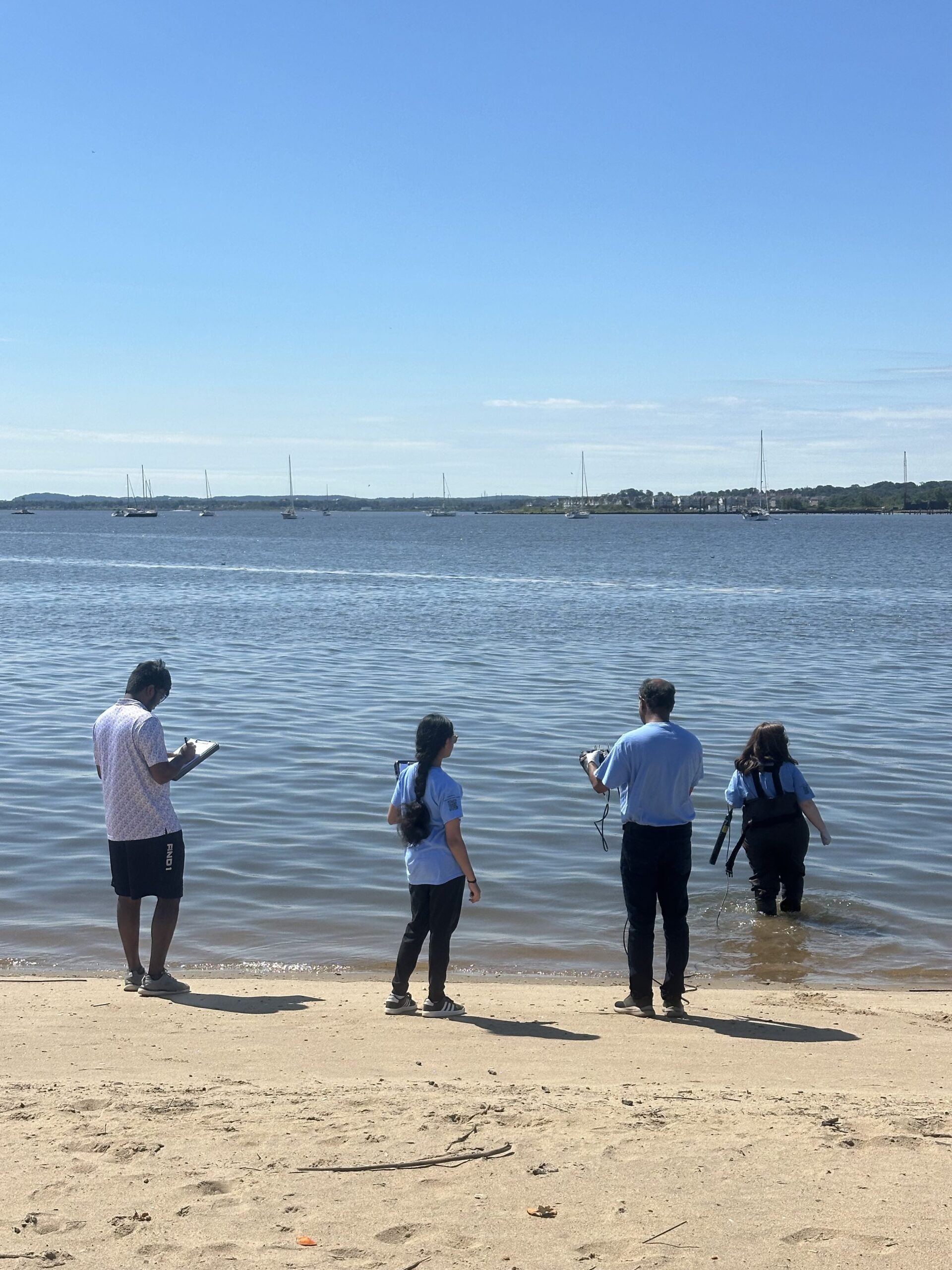
Sanil, Shely and Art cooperating diligently at our first site of the day, LR1 Riverside Park in Piscataway. Photo Credit: Jocelyn Palomino
The vibrant colors of the American flag blowing from the winds at the Edison Boat Basin, HAVE A HAPPY FOURTH OF JULY! Photo Credit: Jocelyn Palomino
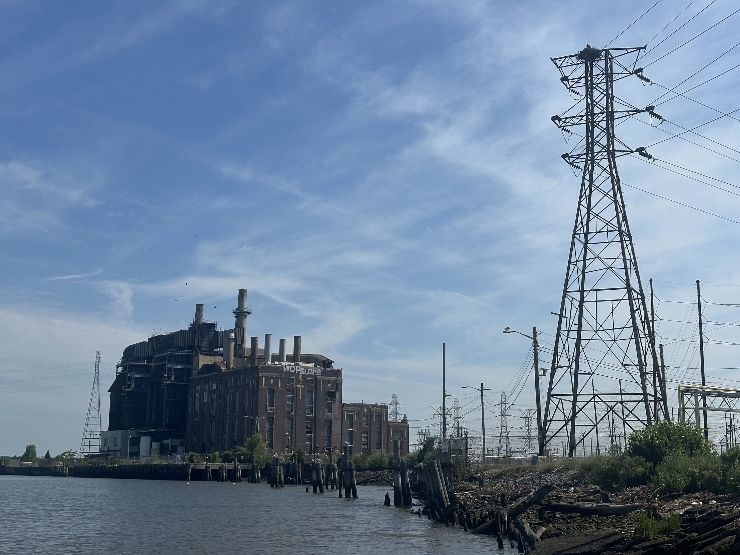
At our Sayreville site (Ken Buchanan Waterfront Park), we got a good look of the osprey nest that rests above the power line. We often see the parents hunting for their young, Photo Credit: Jocelyn Palomino
Sewa volunteer Shely Dash took her turn at wading into our downstream sites, managing both the YSI and sample catching. Thank you Shely! Photo Credit: Jocelyn Palomino
Very low tides at LR6 allowed the team to witness an extreme overflow of untreated sewage directly entering the water at Perth Amboy’s 2nd. Street Park. As always, please be sure to wash up after water-related activities on the Raritan, Photo Credit: Jocelyn Palomino
Every Thursday during the summer, from May to October, the Lower Raritan Watershed Partnership and Rutgers Cooperative Extension of Middlesex County run a volunteer-based monitoring program along the Raritan River. We collect water quality samples at six non-bathing public access beach sites, provide our samples to the Interstate Environmental Commission for analysis in their laboratory, and report the results to the public on Friday afternoons. Our mission is to share this data with the community and partners to ensure the safe use of the Raritan river for all.
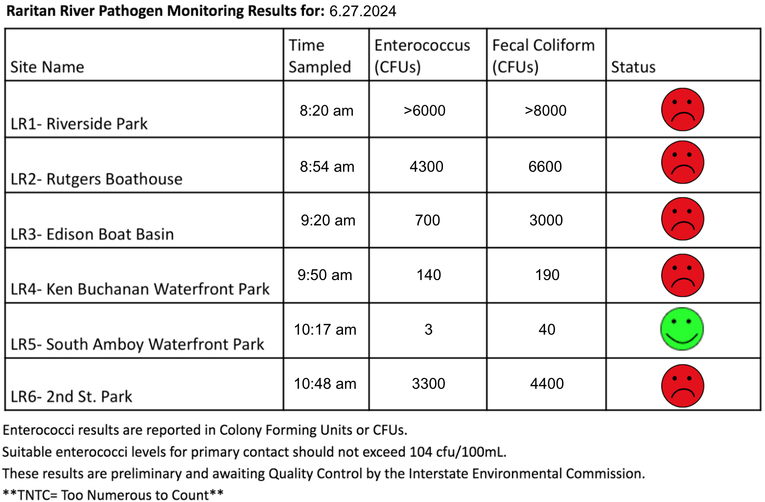
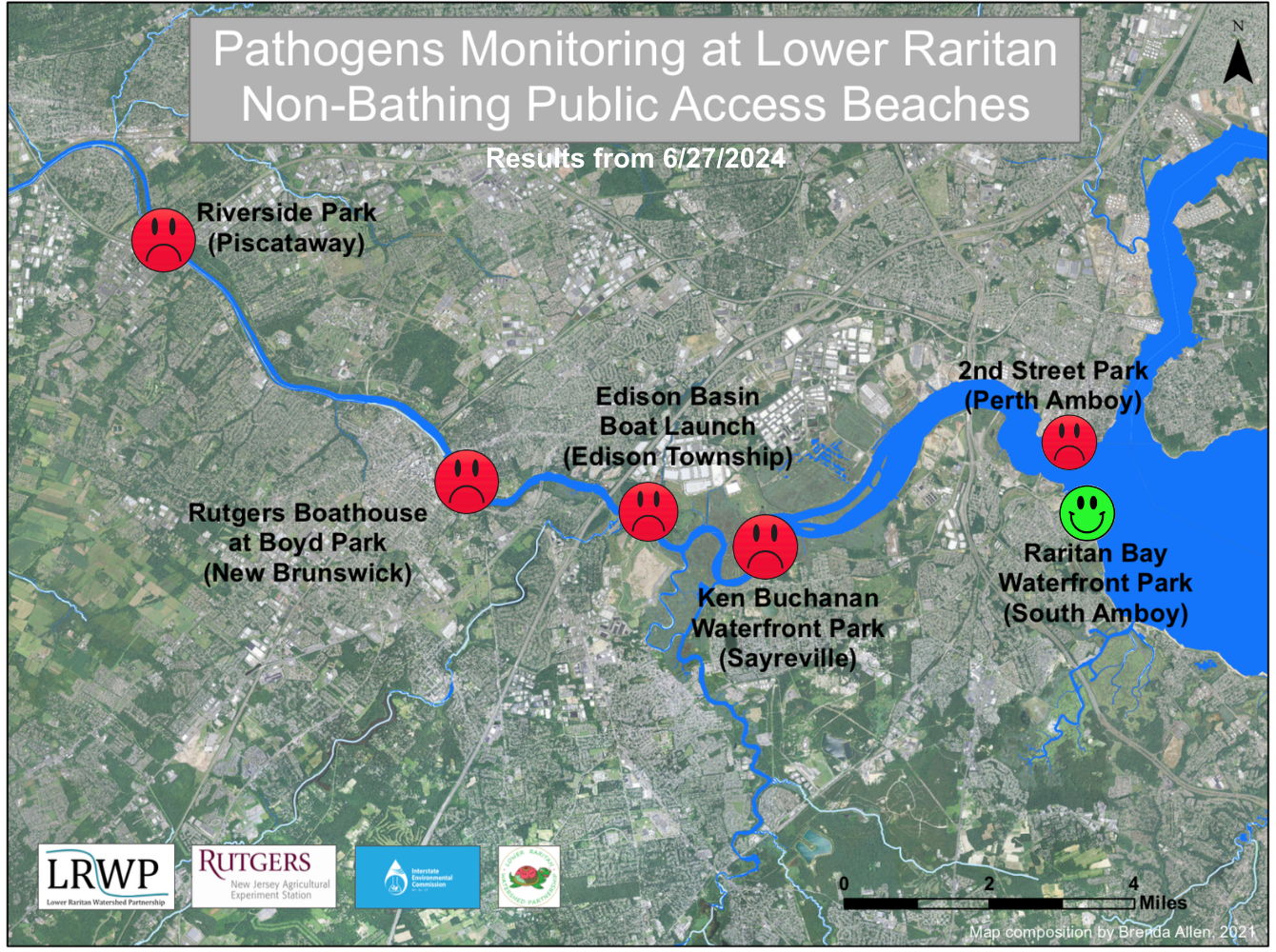
Our lab results for water quality samples taken on Thursday June 27, 2024 show Enterococcus bacteria levels exceeding the EPA federal water quality standard of 104 cfu/100mL at FIVE of our monitoring sites this week. Problem sites are indicated by red frowns on the map and chart which includes: Riverside Park (Piscataway), Rutgers Boathouse (New Brunswick) , Edison Boat Basin and Ken Buchanan Waterfront Park (Sayreville), and 2nd Street Park (Perth Amboy). Green smiles on the chart and map indicate the sites with bacteria levels safe for recreation, and include the following:, and South Amboy Waterfront Park (South Amboy).
Pathogens/Enterococci levels are used as indicators of the possible presence of disease-causing bacteriain recreational waters. Such pathogens may pose health risks to people coming in primary contact with the water (touching) through recreational activities like fishing, kayaking or swimming in a water body. Possible sources of bacteria include Combined Sewer Overflows (CSOs), improperly functioning wastewater treatment plants, stormwater runoff, leaking septic systems, animal carcasses, and runoff from manure storage areas.
Our goal in reporting these results is to give residents a better understanding of the potential health risks related to primary contact during water-based recreation. If you are planning on recreating on the Raritan this weekend, make sure to stay safe and wash up after any activities!
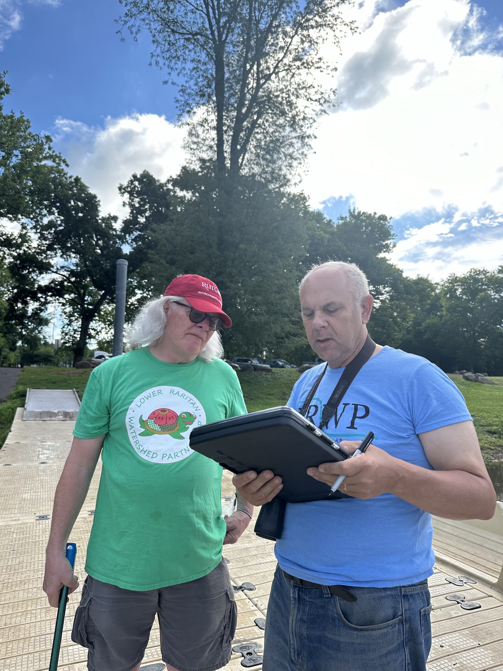
Long-time volunteer Frank Dahl showing first-time water quality volunteer Art Allgauer the ropes on conducting a visual habitat assessment at our monitoring sites, Photo Credit: Jocelyn Palomino
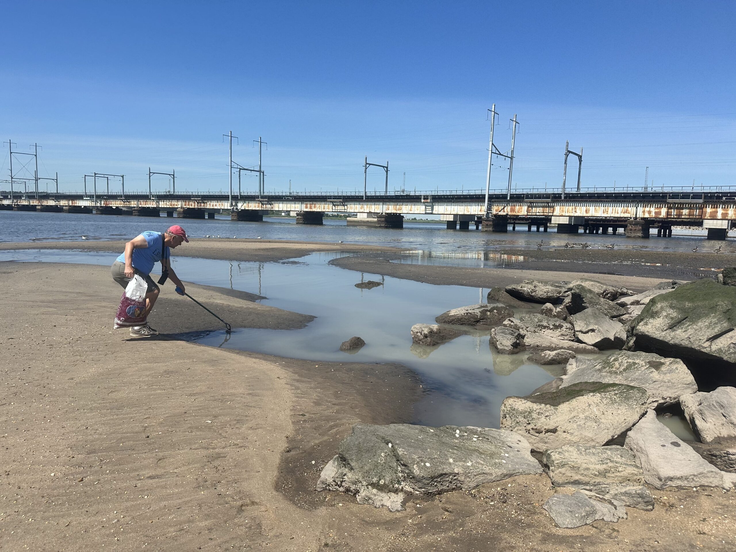
This year, we implemented a new role for volunteers to perform “mini clean-ups” of our sites while the rest of team collects samples and field data, it gives us an opportunity to leave our sites a little cleaner each week, Photo Credit: Jocelyn Palomino
We were also joined by our friends from Sewa International Central Jersey Chapter who were a great contribution to catching our samples for the week: Shely Dash, Thulasi Nambiar and Sanil Nambiar!
Water quality monitoring is indeed a team effort- big thanks to all our volunteers this week for coming out to do their part for the benefit of the community and environment!! Photo Credit: Frank Dahl (left) and Jocelyn Palomino (right)
On Sunday May 19th the LRWP hosted a ribbon cutting for a very special project within the Lower Raritan Watershed, a mechanical in-stream pollution reduction device installed at the Green Brook at the convergence of three towns (Dunellen, Middlesex and Plainfield) and three counties (Somerset, Middlesex and Union). The “Bandalong Bandit Litter Trap” in the Green Brook, designed and manufactured by the Georgia-based Stormwater Systems, Inc. and maintained by the Borough of Dunellen, is the first of its kind in New Jersey.
The Litter Trap project was selected for implementation as part of the Cornell-Dubilier Electronics Natural Resource Damage Assessment and Restoration (NRDAR) Restoration Plan. The Cornell-Dubilier NRDAR Plan is an example of how the nation’s strong Superfund Laws truly hold polluters accountable for environmental damages in our communities. A project seven years in the making, the LRWP appreciates the hard work and dedication of our project partners: Central Jersey Stream Team, the Boroughs of Dunellen and Green Brook, and the Cornell-Dubilier Superfund Site Trustees including the National Oceanic and Atmospheric Administration, the US Fish and Wildlife Service and the New Jersey Department of Environmental Protection. Several members of these organizations were on hand to celebrate installation of this mechanical in-stream pollution reduction device.
The “Bandit Litter Trap” is a floating cage anchored by two booms which direct floating trash into the cage where it is captured to be removed at regular intervals by municipal staff. The device is designed to simplify removal of litter from the waterway, minimizing DPW and volunteer efforts to keep our streams clean, and helping to improve water quality, environmental habitat, and human drinking water supplies. In addition to aiding in management of floatable waste in the Green Brook, the device will help us better understand the types of waste that end up in our local streams, and will help amplify community stewardship efforts for healthier urban waterways throughout the state.
In addition to LRWP Board Members Anton Getz and Heather Fenyk, LRWP Project Coordinator Clare Levourne and Project Volunteer Gregg Bucino, attending the ribbon cutting were Cornell Dubilier Superfund Site Trustee Jillian Stark with the US Fish and Wildlife Service, Dunellen Mayor Jason Cilento, Green Brook Mayor Jim Van Ardsdale, Assemblywoman Linda S. Carter, and Environmental Commissioners and Council members from surrounding towns.
Simultaneous to the ribbon cutting, over a hundred volunteers joined in the annual multi-site clean-up of the Green Brook, with clean-up activities at public parks in Dunellen, Green Brook, Plainfield and Middlesex and thousands of pounds trash were removed from the Green Brook floodplains and waterways. Trash is the most visible form of pollution in the Green Brook, and aquatic trash significantly reduces water quality, damages habitats, and causes aesthetic blight, ecological effects, economic impacts, and potential human health risks.
A key goal of the Litter Trap is to reduce the need for volunteer clean-ups, and to benefit aquatic and semi-aquatic wildlife. To better understand the impact of the Litter Trap on aquatic life going forward, from February-May 2024 the LRWP invited the Green Brook community to partner in a baseline study of American Glass Eel at an artificial eel habitat (an “eel mop”) installed approximately 100 feet upstream of the Litter Trap site. Read more about our eel study, and our findings, here. Apart from improving water quality and benefiting aquatic life, the implementation of the trap should also enhance the area’s aesthetics and improve public perception.
The Bandalong Bandit Litter Trap can operate year-round under various flow conditions without mechanical assistance, but the trash needs to be emptied at appropriate intervals, and the device must be checked after every rainfall exceeding 1 inch. It takes 2-3 months to figure out debris management and to establish a maintenance schedule. Litter surveys and collection of litter data are part of establishing this schedule, and can yield information about device impact. The LRWP will develop an outreach program for Bandalong installation in the Green Brook, including at least two public litter surveys and collection and reporting of litter data. This will involve a partial-volunteer trash removal program with training on how to measure and remove trash from the litter traps. This should also further strengthen community ties and current litter reduction efforts.
This spring’s eel project has been driven by the incredible support and active participation of our community. With thanks to the NY/NJ Harbor & Estuary Program for Project Support, and thanks to all community members who lent a hand: your engagement and dedication have been crucial to our efforts in supporting and h-EEL-ing the American glass eel population.
The LRWP believes that by combining scientific research and community action we strengthen our Lower Raritan community’s connection to local waterways while also highlighting our links to the broader aquatic ecosystem, even across vast distances. Our Spring 2024 eel story suggests far-reaching implications beyond our watershed’s borders.
Why Now? The Ord-EELs Facing the Anguilla rostrata (American Glass Eel) and Their App-EEL As A Symbol of Cultural and Environmental Harmony
The eels are coming! The eels are coming! We here in the Lower Raritan Watershed get to play Paul Revere every time a new crop of juvenile anguilla rostrata, or as they are affectionately known “elvers”, navigate from the Sargasso Sea in the North Atlantic to our local rivers, streams, and estuaries in spring. As one can imagine, an over 1000 mile trek is dangerous for all animals big and small. However, the American glass eels face some unique challenges, or should I say ord-EELs, to get to their (almost) forever home. Unfortunately, the American glass eel is designated as a threatened species by the International Union of Conservation of Nature. This is due to a wide range of problematic issues, including habitat loss, overfishing, pollution, and barriers to migration such as dams and culverts. Although conservation efforts including habitat restoration, regulation of fishing practices, and monitoring of glass eel populations are increasing, there are still significant threats.
The American Glass Eel is particularly vital, serving as both an indicator species and a keystone species across diverse environments, with significant physical and cultural implications. A keystone species is one that boxes outside its weight class, contributing much more to the ecosystem than would be expected. Glass eels specifically regulate prey populations, contribute to nutrient cycling, and serve as indicators of ecosystem health. Though we are familiar with the terminology of a keystone species in an environmental context, we can also use it to refer to species that have integral roles in cultural contexts, specifically within indigenous knowledge systems.
American glass eels hold an essential place in the cultural heritage of Maine’s Passamaquoddy tribe. Elder Donald Socotomah says: “The eels have been part of our traditions forever. We have them in our legends. We have all kinds of stories, thousands of years old.” The interconnectedness of eels with the wider Passamaquoddy culture showcases a very important narrative of community and intergenerational conveyance.
Traditionally, the Passamaquoddy people have relied on the abundance of glass eels as a vital source of sustenance, harvesting them using techniques passed down through generations. Elders within the community play a central role in teaching younger members about the importance of glass eels and the traditional methods of harvesting and preparation. During the spring migration season, members of the Passamaquoddy Tribe gather along the rivers and estuaries of Maine, awaiting the arrival of glass eels. The harvesting of eels becomes a communal activity, bringing together families and clans to celebrate the bounty of nature and reaffirm their cultural identity. Once harvested, glass eels are prepared in accordance with traditional recipes and culinary practices unique to the Passamaquoddy culture. The threatened state of American eels has significantly impacted the cultural traditions of the Passamaquoddy people. To help secure the continuance of the eel population and their cultural traditions, the Passamaquoddy people have developed innovative eel aquaculture practices, and were recently awarded a $4.3 million dollar grant by the USDA Rural Development department as a contribution to their efforts.
However, the interplay of eels within the Passamaquoddy tribe transcends their role as food. Glass eels hold spiritual significance for the Passamaquoddy people, serving as messengers of balance and harmony within the natural world. The health of eel populations is seen as a reflection of the overall well-being of the ecosystem and the interconnectedness of all living beings. This message of harmony and interconnection is not only beautiful but also applicable to the habitat connectedness that our catadromous friends exemplify.
Eel migrations between freshwater and marine environments facilitate the transfer of energy and nutrients, connecting different habitats and supporting biodiversity. In this context, the concept of swimways becomes particularly relevant. Swimways, akin to avian flyways, are emerging as a crucial concept for the conservation of migratory fish, underscoring a significant aspect of cultural connectivity between humans and wildlife. This idea is exemplified by the innovative “fish doorbell” project in Utrecht, Netherlands, where citizens globally assist fish migration by pressing an online doorbell to open canal locks. This community-driven initiative reflects a broader effort by scientists to map and protect fish migration routes worldwide, similar to bird conservation strategies that have successfully preserved flyways across regions and nations. The first global map of swimways includes routes for 665 migratory fish species, highlighting the necessity of international collaboration in safeguarding these critical ecological pathways. Such efforts are pivotal for maintaining biodiversity and ensuring the survival of migratory species, which are increasingly threatened by obstacles like dams, overfishing, and climate change. You can find out more about the multitude of efforts undertaken to develop swimways around the world here: https://academic.oup.com/bioscience/article/72/2/116/6521755
The swimways initiative fosters a deeper understanding and global awareness of the interconnectedness of ecosystems and the cultural responsibility of humans to protect these vital aquatic routes. By supporting the natural migratory patterns of eels and other aquatic organisms, swimways help maintain the intricate web of life that sustains diverse ecosystems. Embracing these pathways not only honors the ecological significance of eels but also aligns with the Passamaquoddy’s and other indigenous tribes’s profound understanding of interconnectedness and balance within the natural world.
This past spring, our community dedicated itself to understanding the profound ecological and cultural significance of eels, striving to deepen our connection to the broader ecological tapestry they represent. To achieve this, we immersed ourselves in every aspect of their conservation, ensuring we became gracious human hosts for our anguillid friends. Our efforts included constructing eel habitats, installing them, regularly monitoring their condition, and re-installing them whenever nature posed challenges. Through this hands-on involvement, we not only contributed to the well-being of the eels but also fostered a greater appreciation for the delicate balance of our shared environment.
These Mops Are The ‘Eel Deal
On March 12, twelve people came and engaged to build artificial eel habitats (a.k.a eel mops). In true citizen science fashion, we assembled these mops entirely out of materials that you could find at your local hardware store! The materials used in our eel mop construction was:
Brown polypropylene rope (25 ft length, 5/8 in. diameter)
Plant Saucer (12 in.)
Cable ties (15 count, medium sized)
Eyebolt (5/16”)
Washer (5/16”)
Extra rope (cut to desired length)
Pie Plates
Cement
Reflecting on the process, the most difficult part was unwinding the polypropylene rope to simulate the grasses. It took a lot of effort but it was sure worth it to make a hospitable home for the eels! After we unfurled the rope, we folded and rubber banded each bundle of rope to create loops. We then marked the saucer with 15 pairs of evenly spaced holes and drilled them, along with a central hole for the eyebolt. After that we attached the rope bundles to the saucer with cable ties, then removed the rubber bands. To secure everything we mixed cement and poured it into a pie tin, placing a plastic-wrapped pencil in the center while it set. After the cement dried (which was a time consuming process too), we attached the cement weight to the saucer with the eyebolt, washer, and bolt. With 12 helping hands, and a process as streamlined as this we were able to construct the eel mop seamlessly and quite quickly. It is important to note however, that despite eel mops being easy to make, in order to deploy the mops you MUST obtain a scientific collection permit from the NYS Department of Environmental Conservation, which the LRWP did prior to the collection process.
Install of the Habitats, Aren’t They Surr-eel?
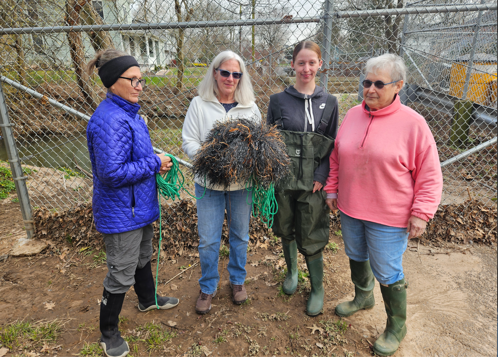
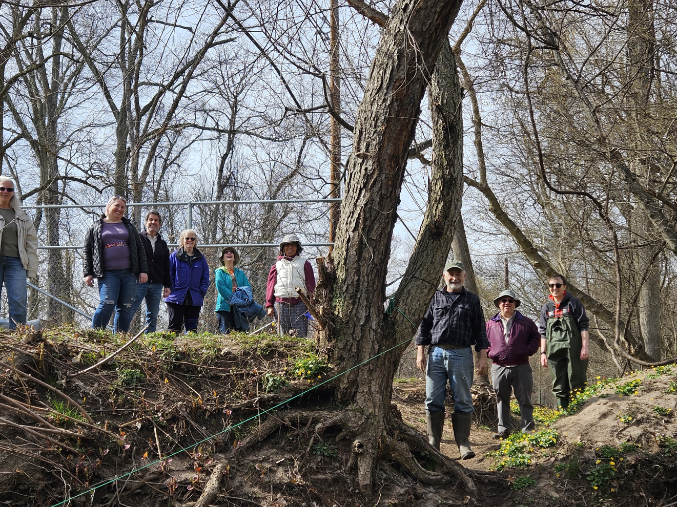
Many who saw the mops thought they consisted of real river grasses. Who knew it was just an optical eel-lusion! On March 26, seven of the LRWP’s volunteers came out to help us install the eel mop in the Green Brook. The hope was that this Eel BnB looked cozy enough to entice some of the migrating glass eels to make it their pit stop.
We were very hopeful about finding eels, as their presence is a strong indicator of a healthy stream ecosystem, but we wouldn’t know until we gave the eels time to settle in.
Having A Hard Time Falling Asleep? Count Eels Instead of Sheep!
March 30th and April 13th, were our eel counting days. Unfortunately, the anguilla rostrata remained eel-lusive. Over those two days 15 wonderful volunteers checked the eel mop for inhabitants. Though we didn’t find any eels on those days we still found some macroinvertibrate friends, including very exciting dragonfly larvae! Akin to the eels, dragonflies are also an indicator species, and their presence let us know we were doing everything we can to be inviting hosts, the eels were just late to the party. Unfortunately, on our April 13th monitoring day we found out that our eel mop had broken due to damage from a big storm, so we had to remove the eel mop for repairs.
Big Storms Sure Aren’t Id-eel…
The damage from the storm certainly put a dent into our springtime monitoring plans, but we did our best to get the eel mop patched up as quickly as possible. On May 18, two of the LRWP’s board members, Heather Fenyk and Anton Getz, reinstalled the mop to see if the renovated home would entice some eels during the tail end of the season. The reinstall went quite smoothly and we looked forward to the last monitoring day of the season.
Fun Fact: Eels Are Fashionably Late to Gatherings, But We Love to Have Them Anyway!
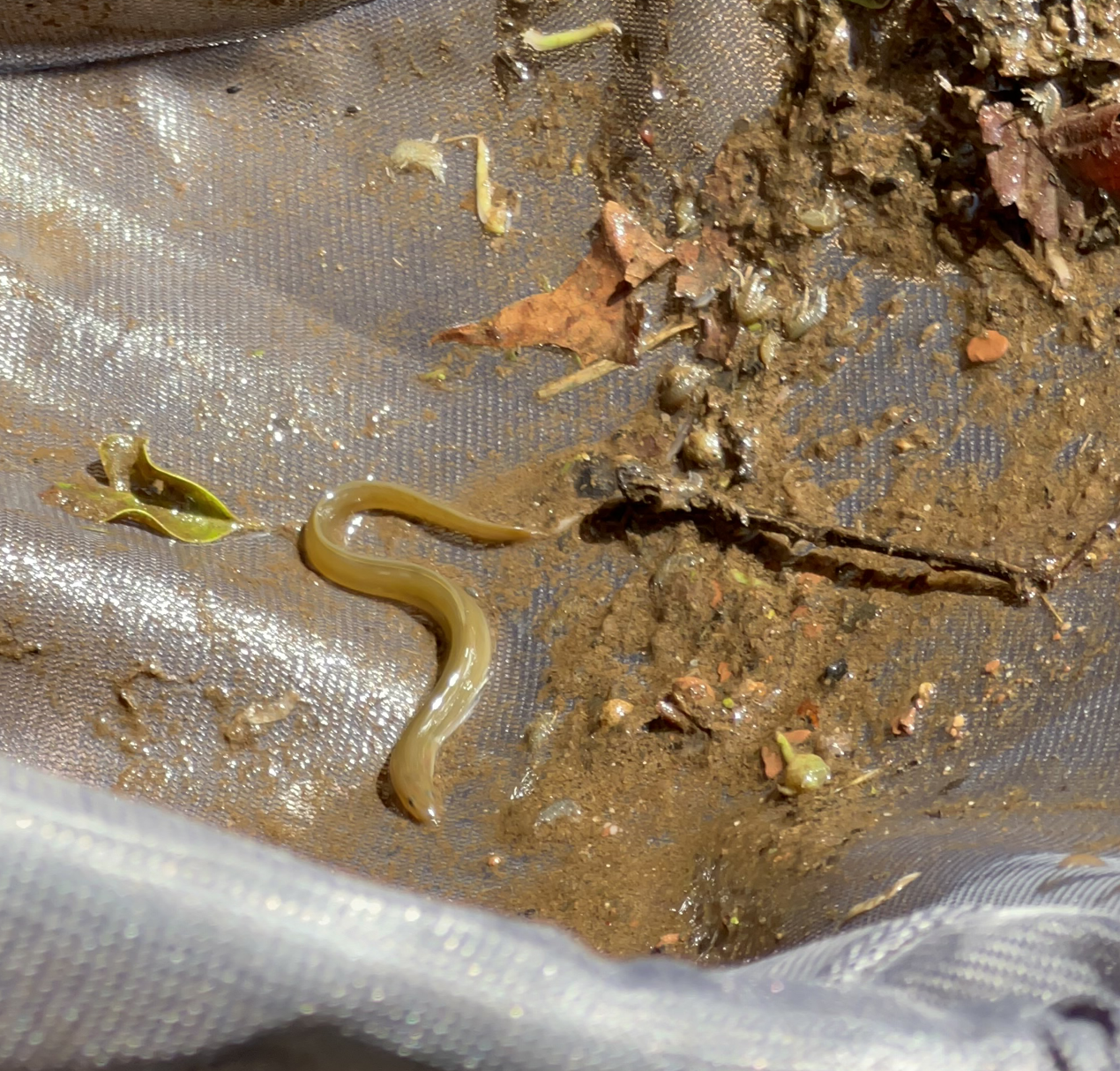
On our last day of monitoring May 25, a week after the reinstall of the eel mop, we found a singular juvenile American glass eel. Eleven volunteers squealed in unison at the sight.
We measured our new friend and found that they were about 3.5 inches long and had started developing pigment. Based on research guidelines these characteristics would place this glass eel into the early elver stage of development, and approximately just over a year old. Happy 1st Birthday! Of course after a lot of oohing and ahhing, picture-taking, and measurements, we put the eel back into the Green Brook for it to continue to grow to adulthood in our streams. We can’t convey how exciting it is to have the American glass eel confirmed as present in the Lower Raritan Watershed. Their arrival truly signals a thriving stream, and we’re so grateful that the health of the Green Brook is being reflected in the biodiversity.
What’s Next? Our Eel Spi-eel.
Though the Lower Raritan Watershed Partnership engages in a variety of habitat assessment, macroinvertebrate, and pathogens monitoring projects, this was the first year that we were able to participate in eel monitoring. We embarked on this specific project in 2024 as a joint effort with installation of the Stormwater Systems Bandalong Bandit Litter Trap just downstream of the eel mop. The Litter Trap was installed in the aquatic nexus of Green Brook Borough, Dunellen Borough, and Plainfield – with the goal of relieving litter flows from this problem area. We are so proud of the work that we have done to both heal and observe the Green Brook, and the community involvement that has made both the projects a reality.
Our goals for the 2024 Glass Eel monitoring cycle were multifold:
To establish a baseline for eel data for the portion of the Green Brook.
Provide insight into the litter reduction project impact on aquatic life in the portion of the Green Brook.
Give a voice to the link between litter reduction and environmental health within the context of a high profile and multi-municipality project.
Engage community members in hands-on civic science environmental education activities, providing data regarding migratory behavior of spring eels in a neglected waterway.
Enhance public perception and usability of recreational areas along the Raritan River.
Despite some setbacks, we successfully accomplished all of these goals this monitoring cycle. We were able to establish the baseline through successful eel capture, with the timing of our discovery providing valuable insights into seasonal eel observations in our waterway. Additionally, our efforts shed light on a simultaneous litter reduction project, highlighted by the installation of New Jersey’s first litter trap. This milestone speaks volumes about our community’s dedication to the health of the lower Raritan watershed. Continued commitment from the community is propelling biodiversity and environmental health on an upward trajectory. As of 2024, we celebrate the fourth year of multi-site, multi-municipality clean-ups along the Green Brook, building on years of targeted efforts. Since our concentrated community initiatives began, several tons of litter have been removed from the Green Brook, marking significant progress in our shared environmental stewardship. This also speaks volumes towards our goal of highlighting the link between litter reduction and environmental health. Furthermore, throughout the project, the LRWP engaged 40 volunteers in the different stages of the eel mop build, installation, and monitoring. This gave 40 community members hands-on experience in environmental education and civic science. Through this community engagement initiative, we also successfully improved the public perception and usability of recreational areas along the Raritan River.
Our journey through eel monitoring has not only deepened our understanding of ecological interconnectedness but also strengthened community bonds and environmental stewardship. Despite challenges, including storm damage and the eels’ tardy arrival, our perseverance and community spirit prevailed. The successful establishment of an eel baseline and insights into our litter reduction project underscore our commitment to the health of the lower Raritan watershed. As we look ahead, we remain dedicated to fostering biodiversity and enhancing public enjoyment of our precious waterways. This collaborative effort has empowered dozens of volunteers with hands-on environmental education, building a community focused on restoration for the Raritan River and larger watershed. We eagerly anticipate future eel monitoring endeavors, pending securing the necessary funding. This project has exemplified the strength of community collaboration, and we aspire to build upon these achievements with future initiatives.
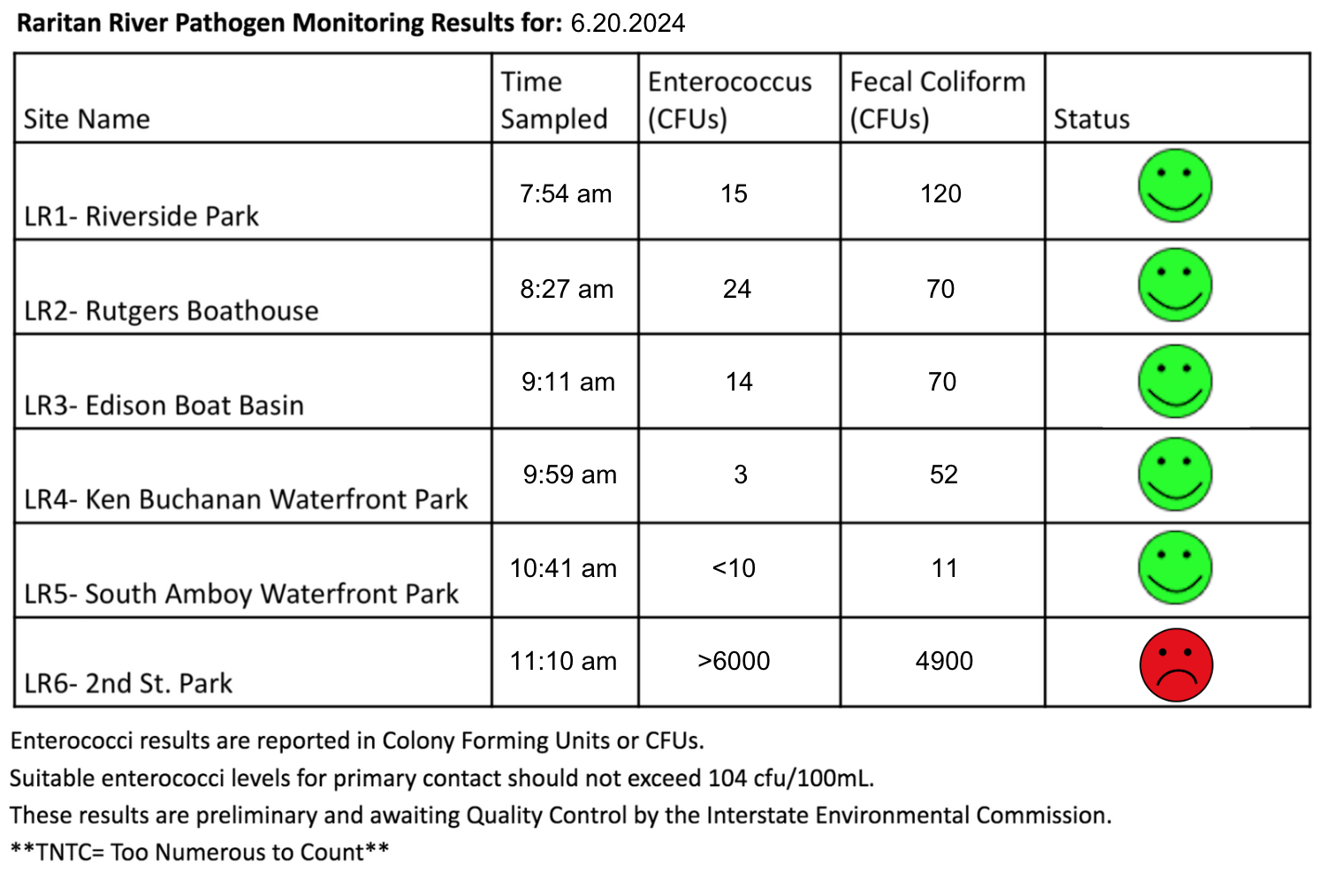
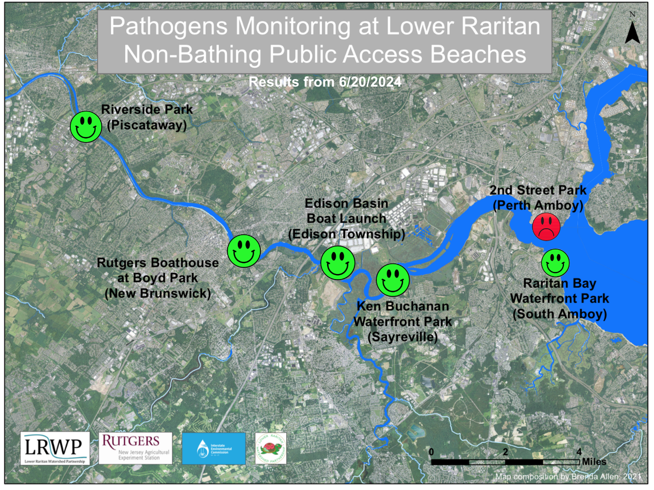
Every Thursday during the summer, from May to October, the Lower Raritan Watershed Partnership and Rutgers Cooperative Extension of Middlesex County run a volunteer-based monitoring program along the Raritan River. We collect water quality samples at SIX non-bathing public access beach sites, provide our samples to the Interstate Environmental Commission for analysis in their laboratory, and report the results to the public on Friday afternoons. Our mission is to share this data with the community and partners to ensure the safe use of the Raritan river for all.
Our lab results for water quality samples taken on Thursday June 20, 2024 show Enterococcus bacteria levels exceeding the EPA federal water quality standard of 104 cfu/100mL at only one of our monitoring sites this week. Problem sites are indicated by red frowns on the map and chart for 2nd Street Park (Perth Amboy) this week. Green smiles on the chart and map indicate the sites with bacteria levels safe for recreation, and include the following: Riverside Park (Piscataway), Rutgers Boathouse (New Brunswick) , Edison Boat Basin and Ken Buchanan Waterfront Park (Sayreville), and South Amboy Waterfront Park (South Amboy).
Pathogens/Enterococci levels are used as indicators of the possible presence of disease-causingbacteriain recreational waters. Such pathogens may pose health risks to people coming in primary contact with the water (touching) through recreational activities like fishing, kayaking or swimming in a water body. Possible sources of bacteria include Combined Sewer Overflows (CSOs), improperly functioning wastewater treatment plants, stormwater runoff, leaking septic systems, animal carcasses, and runoff from manure storage areas.
Our goal in reporting these results is to give residents a better understanding of the potential health risks related to primary contact during water-based recreation. If you are planning on recreating on the Raritan this weekend, make sure to stay safe and wash up after any activities!
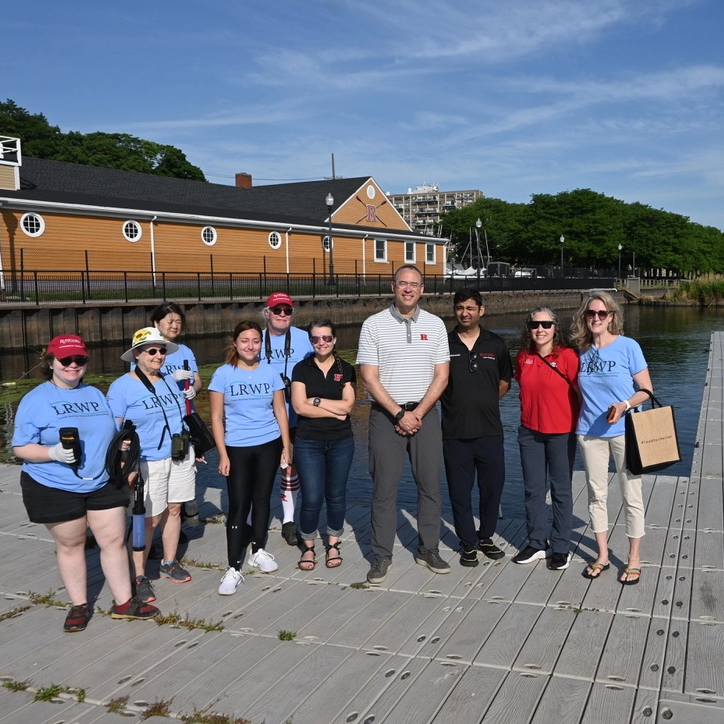
This week, we were fortunate enough to be joined by Rutgers President Holloway at our second monitoring site: The Class of 1914 Rutgers Boathouse! Photo Credit: Trish Maguire
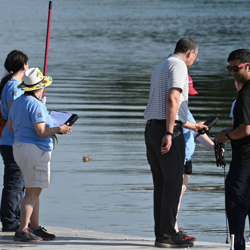
Our volunteers took the reins yesterday and demonstrated how we conduct water quality monitoring as a collective team, check out President Holloway holding our YSI equipment!Photo Credit: Trish Maguire
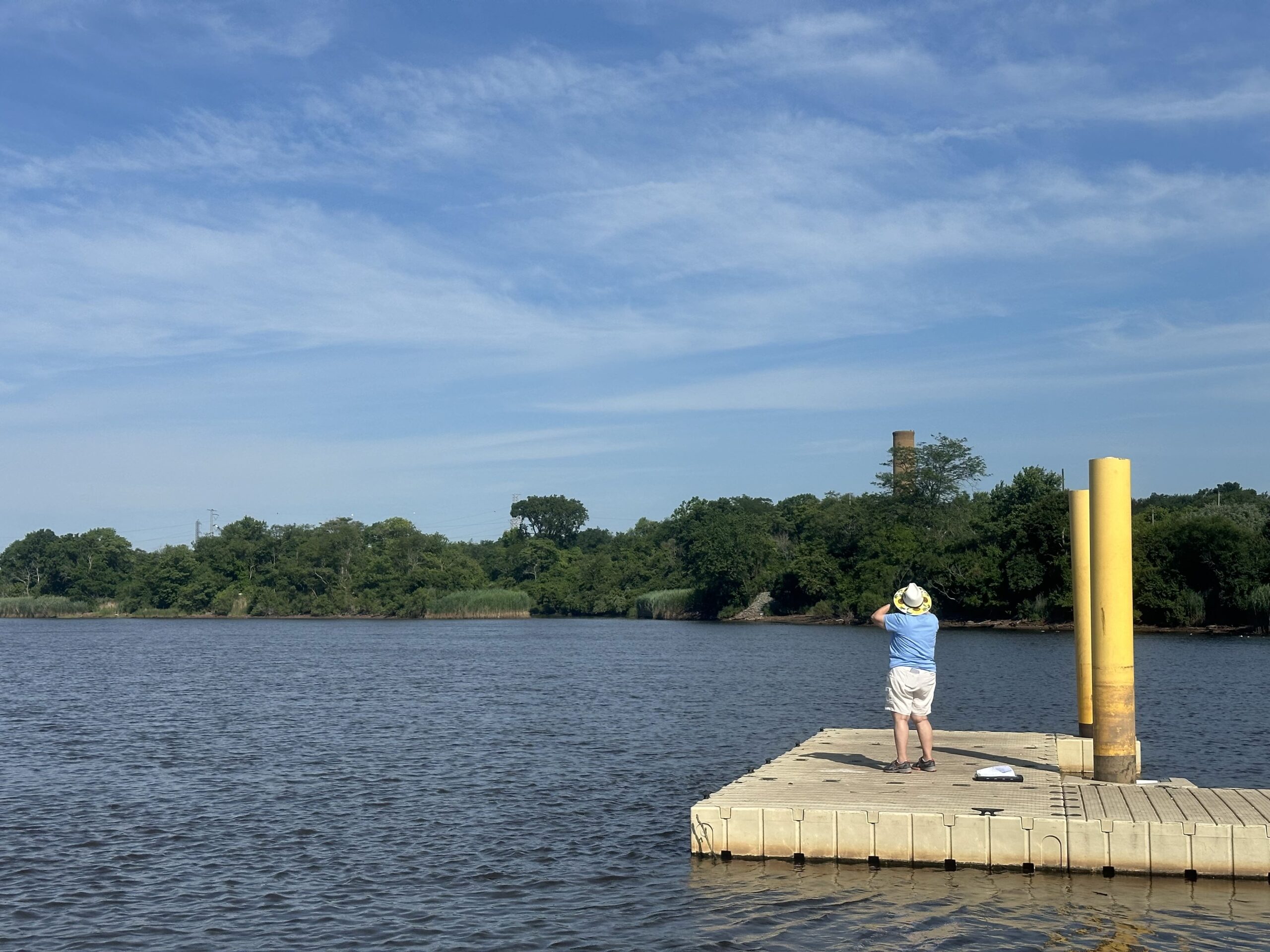
Irene Riegner looking intently through her binoculars to complete our field observation and identify any wildlife present in the area at the time of sampling, Photo Credit: Jocelyn Palomino
Can you spot the osprey nest at our Sayreville site? Photo Credit: Jocelyn Palomino
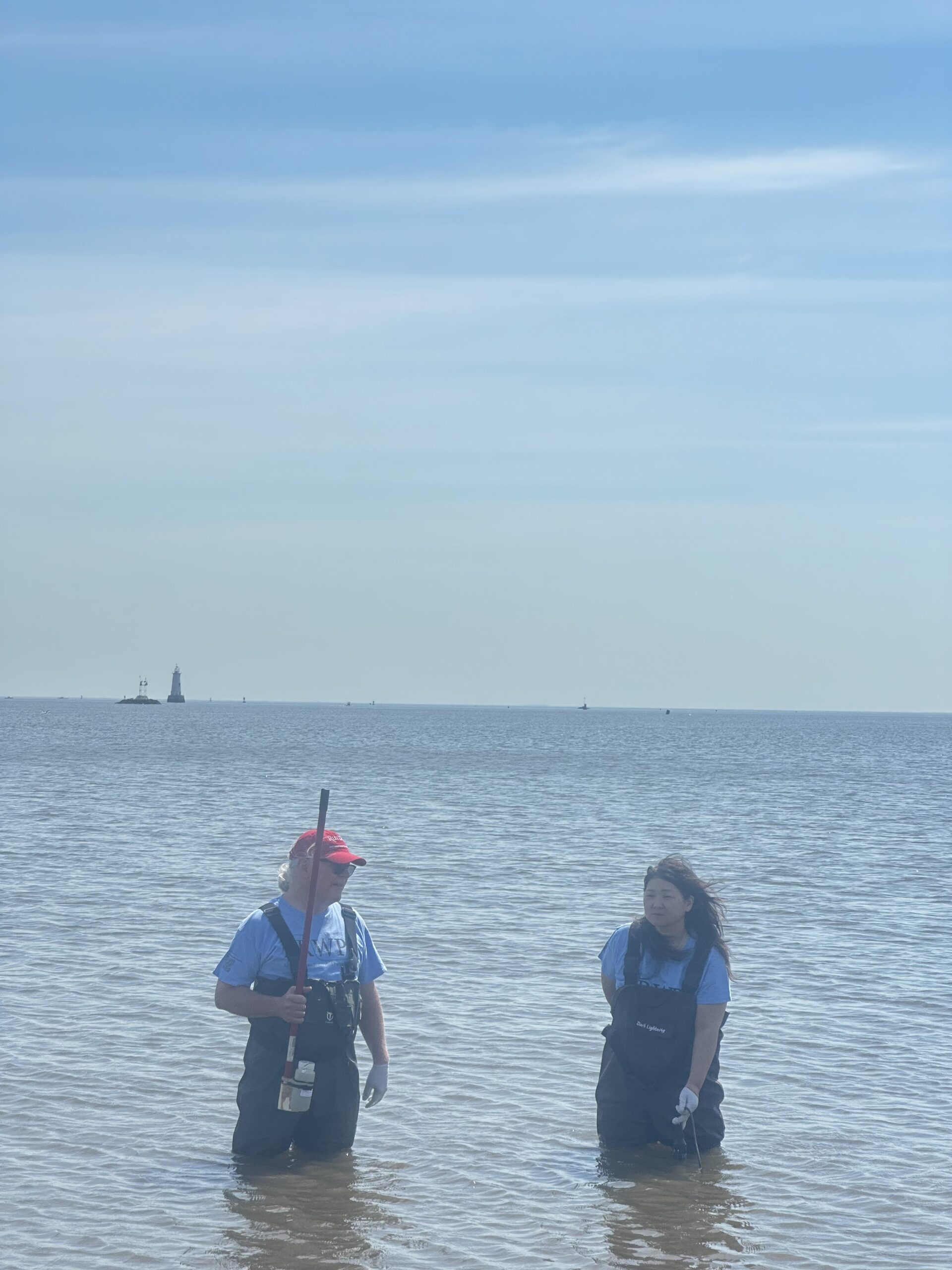
Frank Dahl and Amane Kariya suited up in waders together to collect our sample and data for our South Amboy site, thank you both! Photo Credit: Jocelyn Palomino
The team pictured at our last monitoring location of the day, helping Amane who managed to handle the YSI and sample catching all-in-one go, Photo Credit: Frank Dahl
By LRWP Monitoring Outreach Coordinator Jocelyn Palomino
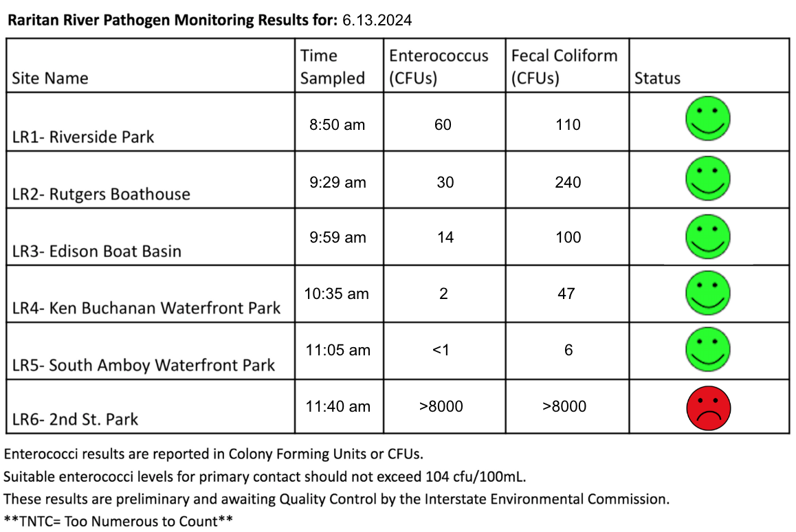
During the summer, the Lower Raritan Watershed Partnership and Rutgers Cooperative Extension of Middlesex County run a volunteer-based monitoring program along the Raritan river that takes place every Thursday, from May to October. We collect water quality samples at SIX non-bathing public access beach sites, provide our samples to the Interstate Environmental Commission for analysis in their laboratory, and report the results to the public on Friday afternoons. Our mission is to share this data with the community and partners to ensure the safe use of the Raritan river for all.
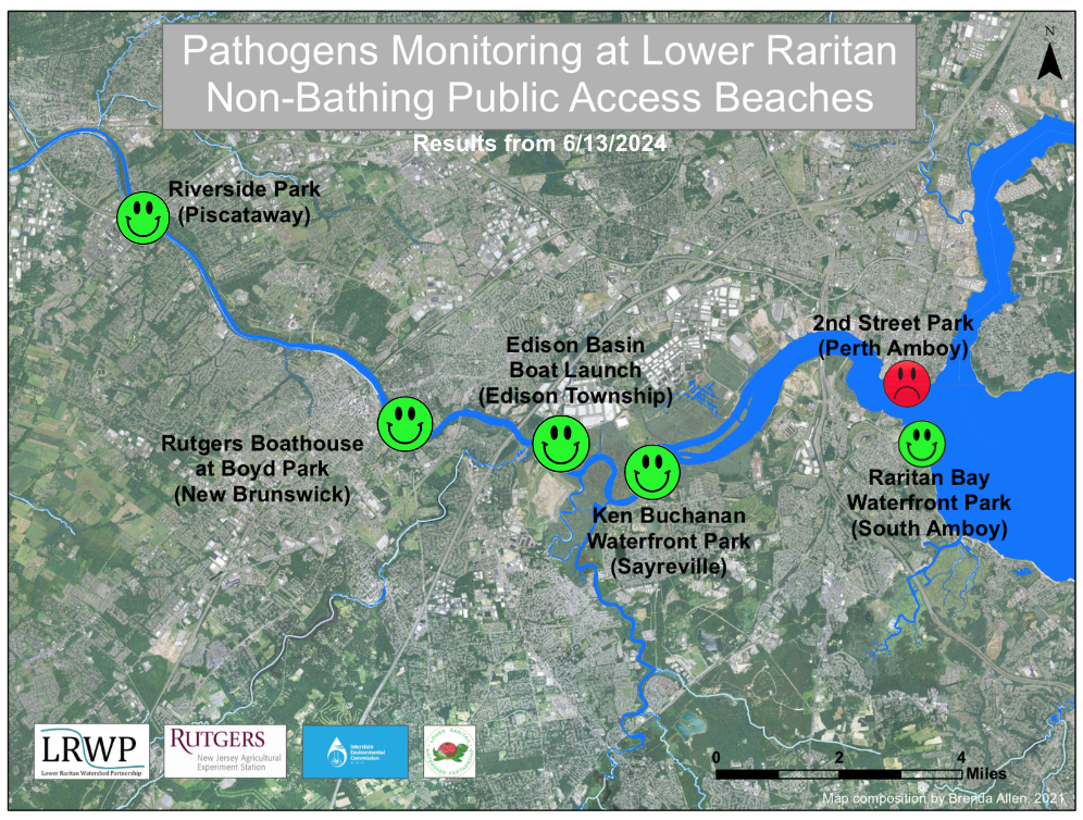
Our lab results for water quality samples taken on June 13, 2024 show Enterococcus bacteria levels exceeding the EPA federal water quality standard of 104 cfu/100mL at only one of our monitoring sites this week. Problem sites are indicated by red frowns on the map and chart which includes: 2nd Street Park (Perth Amboy). Green smiles on the chart and map indicate the sites with bacteria levels safe for recreation and include: Riverside Park (Piscataway), Rutgers Boathouse (New Brunswick) , Edison Boat Basin and Ken Buchanan Waterfront Park (Edison), and South Amboy Waterfront Park (South Amboy).
Pathogens/Enterococci levels are used as indicators of the possible presence of disease-causingbacteriain recreational waters. Such pathogens may pose health risks to people coming in primary contact with the water (touching) through recreational activities like fishing, kayaking or swimming in a water body. Possible sources of bacteria include Combined Sewer Overflows (CSOs), improperly functioning wastewater treatment plants, stormwater runoff, leaking septic systems, animal carcasses, and runoff from manure storage areas.
Our goal in reporting these results is to give residents a better understanding of the potential health risks related to primary contact during water-based recreation. If you are planning on recreating on the Raritan this weekend, make sure to stay safe and wash up after any activities!
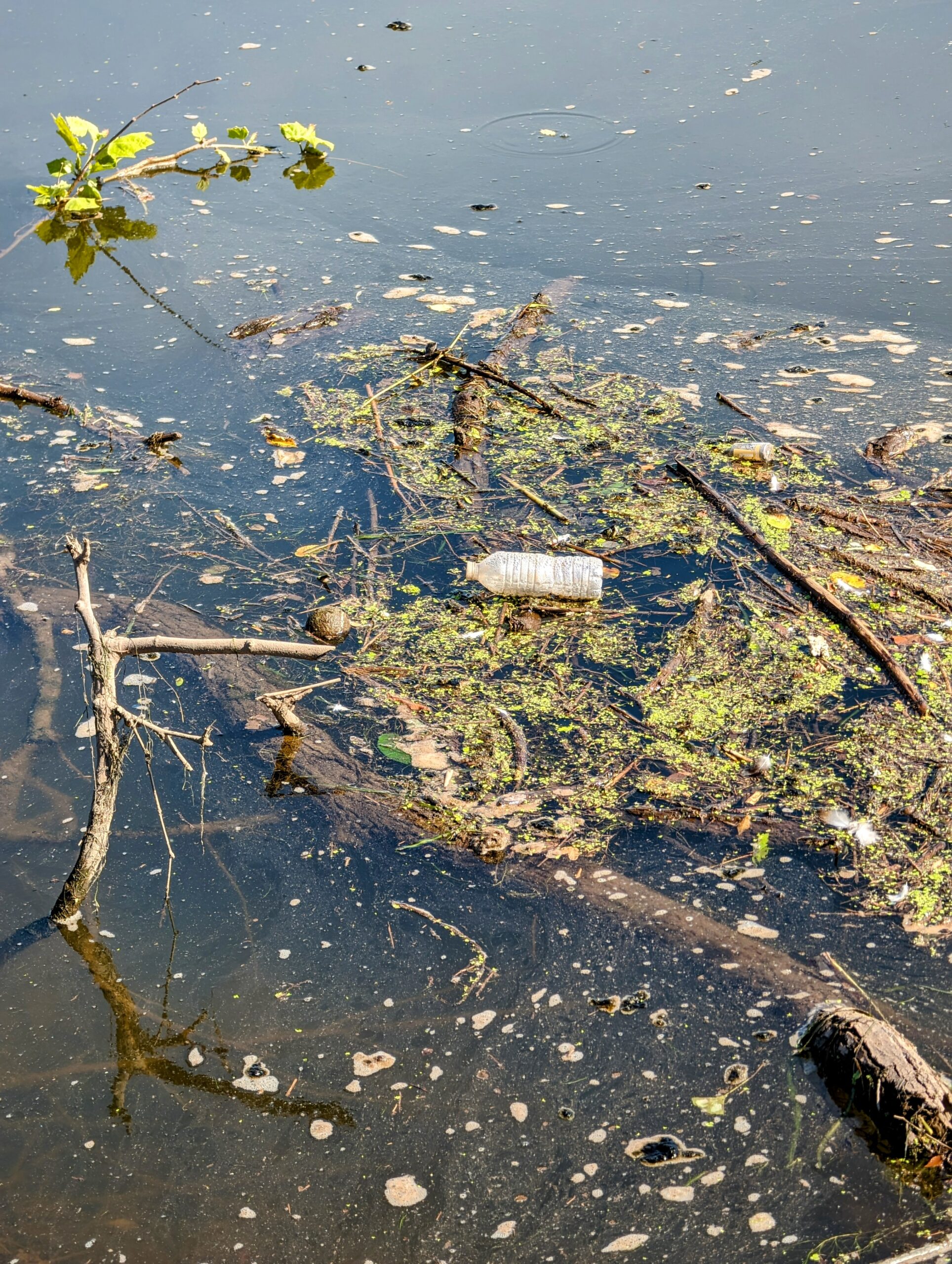
A large flow of debris, geese poop and trash in the waters at the Rutgers Boathouse docks, Photo Credit: Rose Lawless
An osprey nest at Ken Buchanan Waterfront Park we have observed over the years, only a fraction of the abundant wildlife out on the Raritan! Photo Credit: Rose Lawless
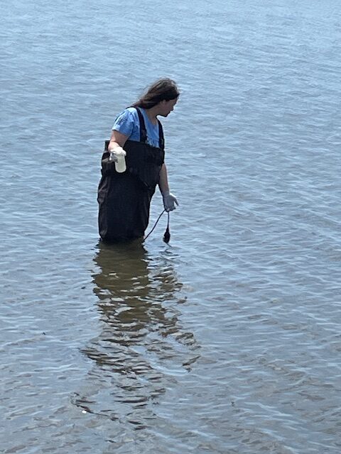
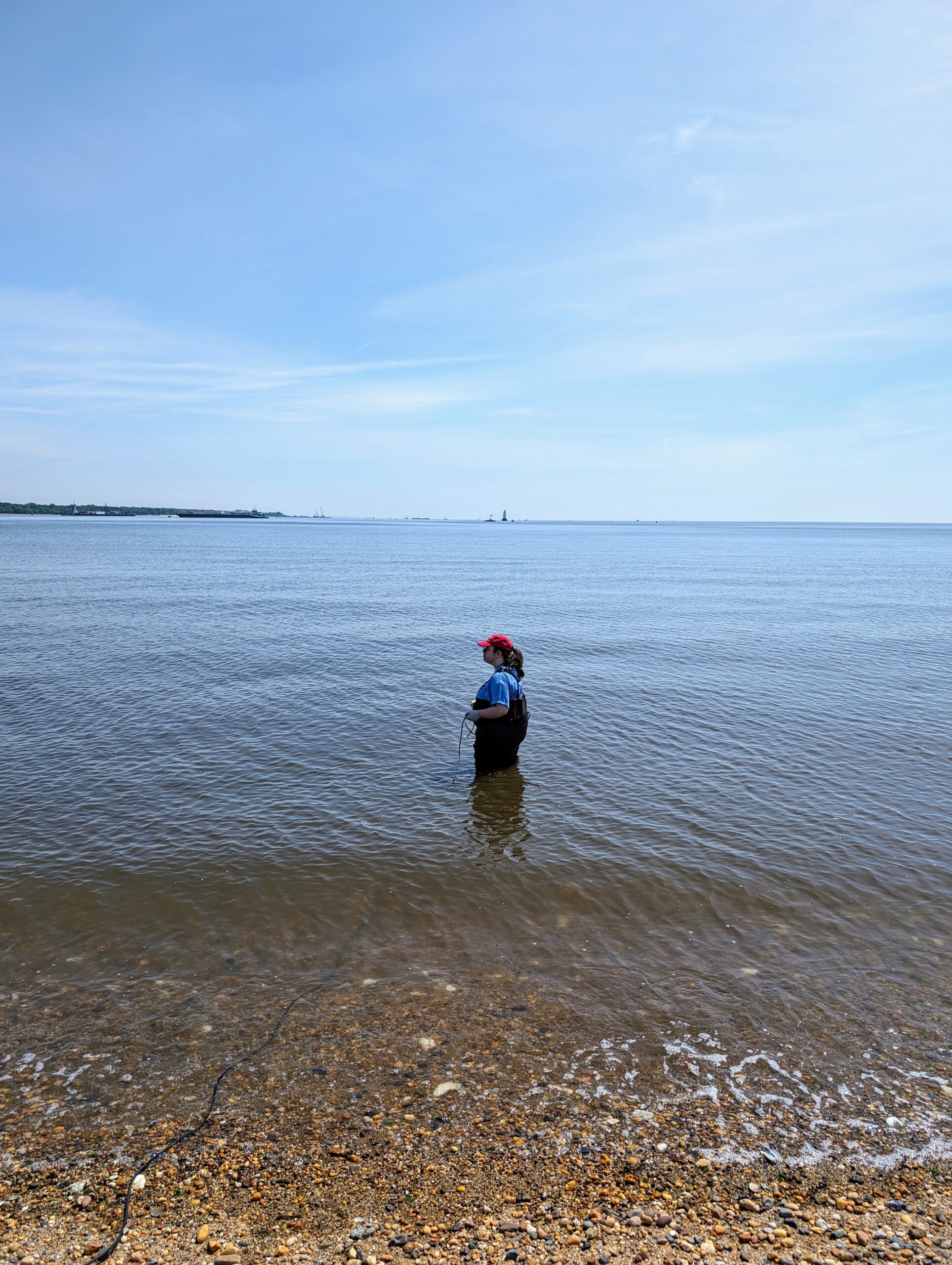
Sofi Grossman threw the waders on for the first time in South Amboy Waterfront Park, thank you Sofi!! Photo Credit: Rose Lawless
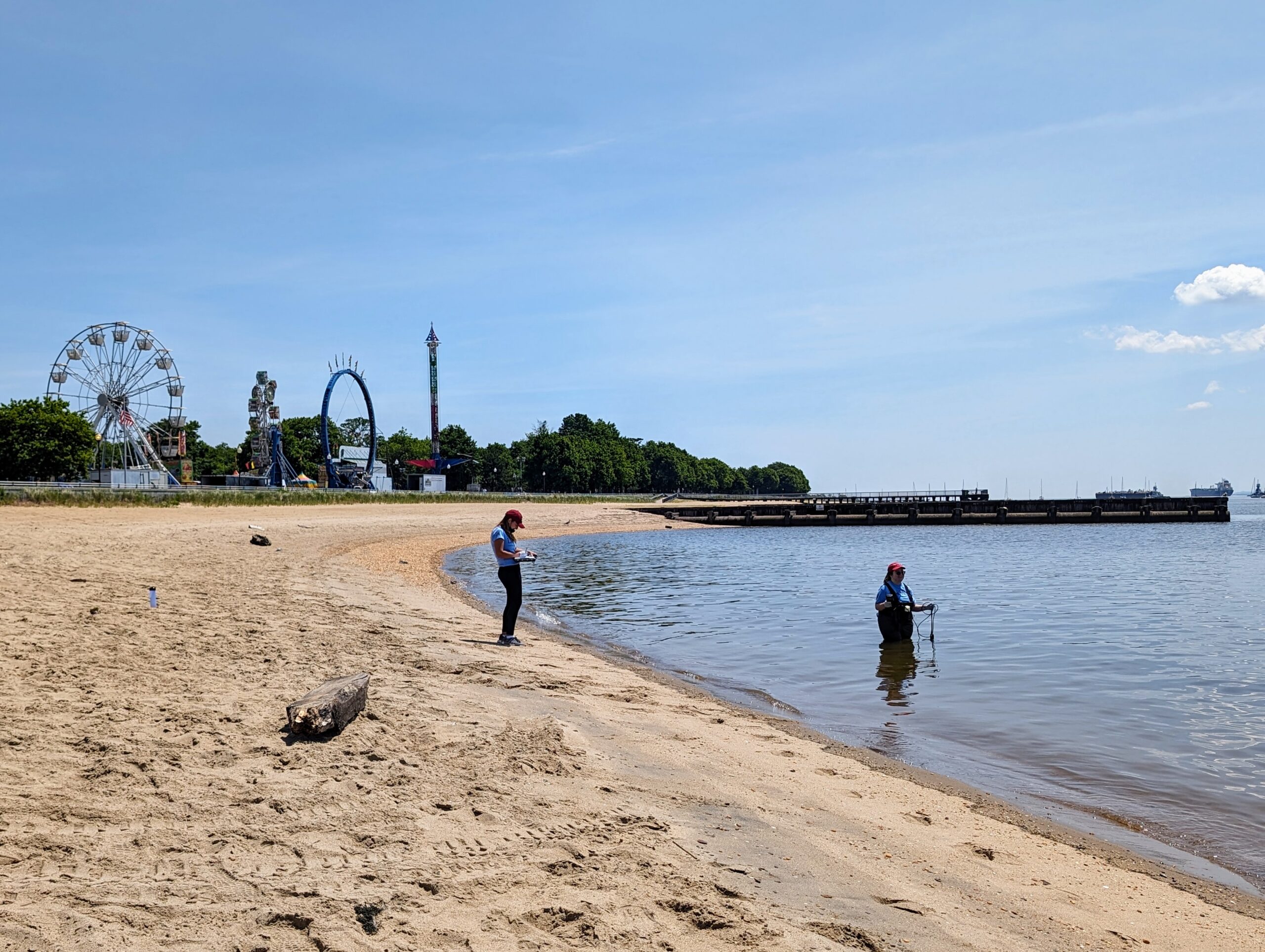
Jocelyn Palomino and Sofi Grossman collecting data for the weekend at 2nd. Street Park with the Perth Amboy Carnival in the back, be sure to stay safe by the water! Photo Credit: Rose Lawless