The LRWP and Rutgers Cooperative Extension of Middlesex County monitor for Fecal Coliform and Enterococcus at six non-swimming public beach access sites along the Lower Raritan during the warmer summer months. Fecal Coliform and Enterococcus are indicators of disease-causing bacteria in our waterways.
The EPA recommends that a single Enterococcus sample be less than 110 Colony Forming Units (CFU)/100mL for primary contact. Enterococci levels are used as indicators of the possible presence of disease-causing bacteria in recreational waters. Such pathogens may pose health risks to people fishing and swimming in a water body. Sources of bacteria include Combined Sewer Overflows (CSOs), improperly functioning wastewater treatment plants, stormwater runoff, leaking septic systems, animal carcasses, and runoff from manure storage areas. Enterococci levels are often high after heavy or consistent rainfall.
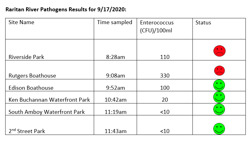
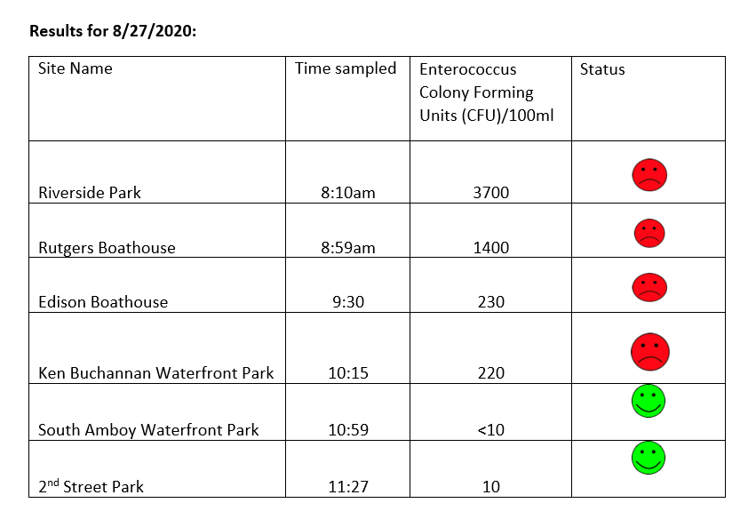
Here are our pathogens results for September 17, 2020. Things are looking good for our Raritan, and with no rain predicted for the next few days our waters should be flowing pretty clean.
Please note: results are preliminary and pending quality control.
Pathogens Results for Raritan River Public Access Non-Swimming Beach Sites
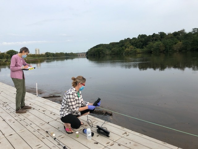
Field Notes for 9.17.2020
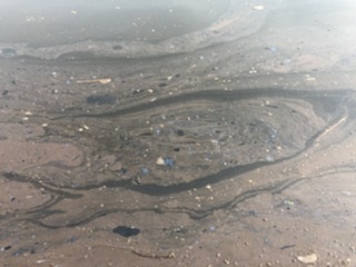
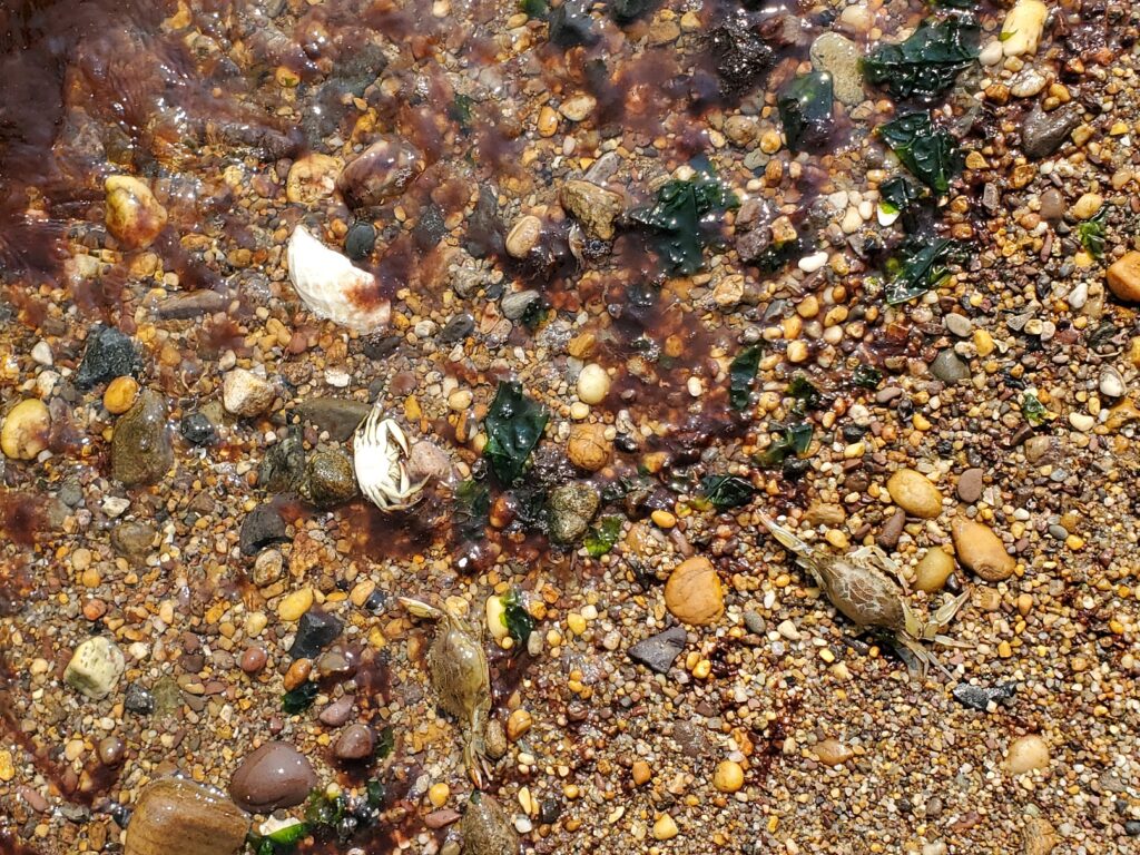
Hazy yellow skies during the day told a story of west coast fires and kept the temps down. Yesterday was a beautiful day for monitoring. Waters at our Rutgers Boathouse were covered with thick oily scum, origin undetermined. A far number of dead bunker floating in the water at our Edison Boat launch site. And there is still a fair amount of red algae at the South Amboy site – the algae has spread some to Perth Amboy.
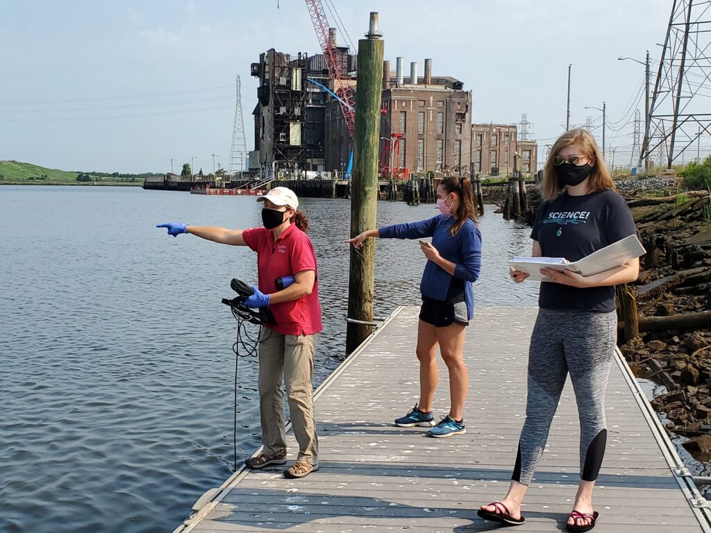
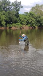
Susan and Heather capturing data and taking notes at Rutgers Boathouse site photo: Jessica Bonamusa
LOTS of scum, oil and muck at Rutgers Boathouse – photo: Jessica Bonamusa
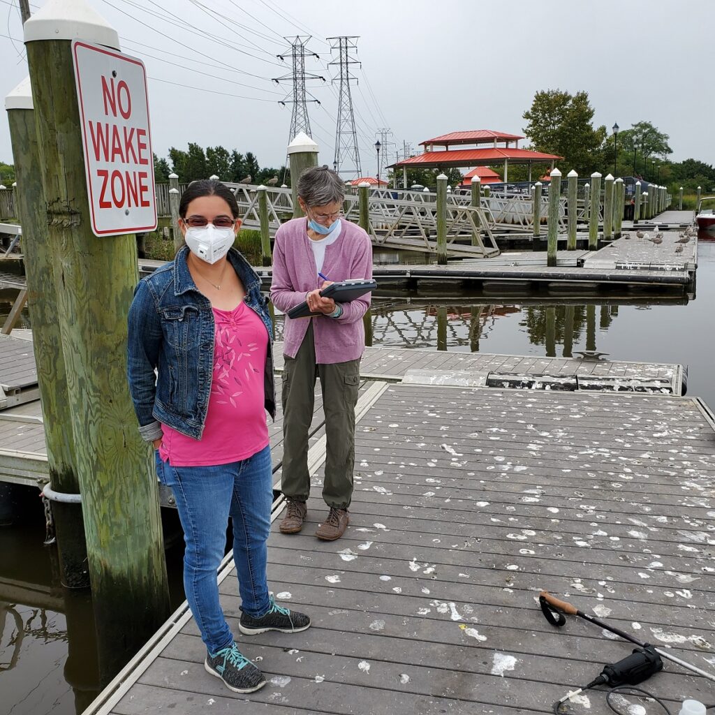
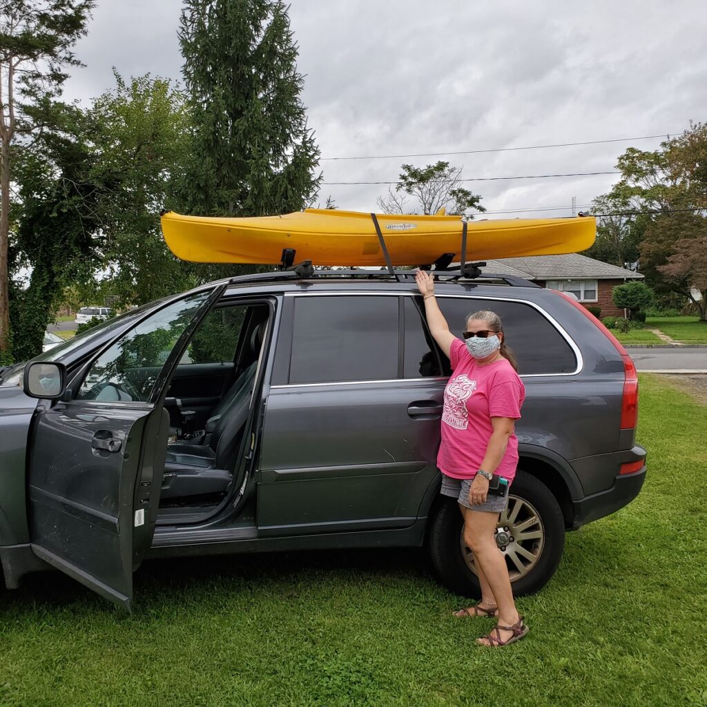
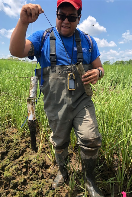
Jessica (IEC lab) and volunteer Susan making note of all the gull poop at the Ken Buchanan site in SayrevilleWe received a kayak loaner from our Raritan Riverkeeper friends to help us in our source track down and scouting. Thank you Bill Schultz and Lorraine!
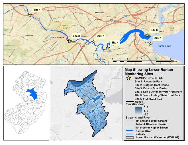
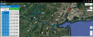
Summer 2020 Raritan Monitoring Sites
The New Jersey state Department of Environmental Protection and Middlesex County Health Departments typically monitor at sanctioned public swimming beach sites. They do not monitor the water quality for pathogens at public access non-swimming beach sites along the Raritan, despite regular use of these areas for primary contact (fishing and swimming) by members of our urban communities.
The LRWP works with in partnership with the Interstate Environmental Commission for lab analysis of our samples. We have a Quality Assurance Protocol Plan (QAPP) approved by the federal Environmental Protection Agency. We work to report our results as soon as lab analysis is completed.
Photos and article by LRWP Board President Heather Fenyk
The LRWP and Rutgers Cooperative Extension of Middlesex County monitor for Fecal Coliform and Enterococcus at six non-swimming public beach access sites along the Lower Raritan during the warmer summer months. Fecal Coliform and Enterococcus are indicators of disease-causing bacteria in our waterways.
The EPA recommends that a single Enterococcus sample be less than 110 Colony Forming Units (CFU)/100mL for primary contact. Enterococci levels are used as indicators of the possible presence of disease-causing bacteria in recreational waters. Such pathogens may pose health risks to people fishing and swimming in a water body. Sources of bacteria include Combined Sewer Overflows (CSOs), improperly functioning wastewater treatment plants, stormwater runoff, leaking septic systems, animal carcasses, and runoff from manure storage areas. Enterococci levels are often high after heavy or consistent rainfall.
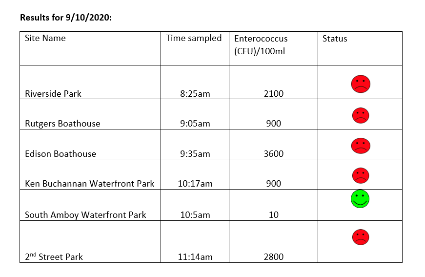
Here are our pathogens results for September 10, 2020. Please note that we received over an inch of rain in our Lower Raritan monitoring areas the evening after monitoring. As such we expect pathogens levels to be much higher than what was sampled in the morning.
Please note: results are preliminary and pending quality control.
Pathogens Results for Raritan River Public Access Non-Swimming Beach Sites
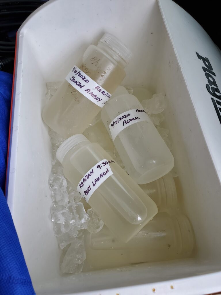
Field Notes for 9.10.2020
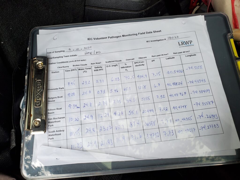
Lots of rain while monitoring our first three sites on September 10, 2020 made for a soggy day. The water at all sites was dark brown and thick with sediment from upstream. Our rain gauge showed 1.52 inches when we checked it the morning after monitoring. Most of that rainfall occurred on September 10 between 7-10 pm. Please take extra care when in any waterway after rainfall, especially heavy rains that send so much sediment and waste into our local streams and River.
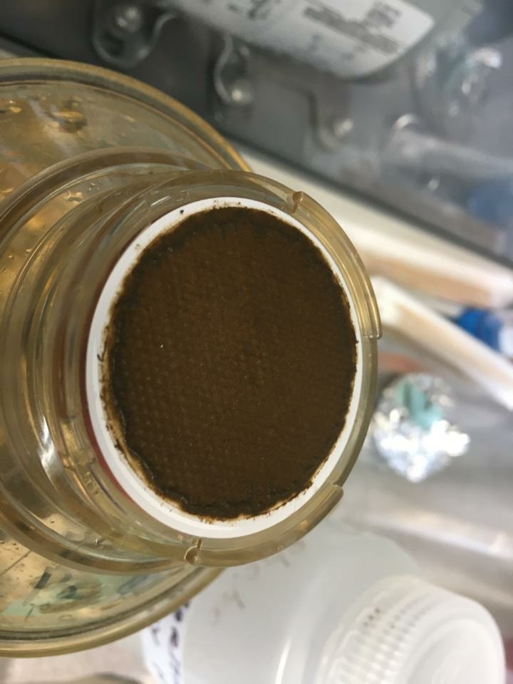
In addition to capturing water quality samples we collect data on salinity, temperature, dissolved oxygen, pH and other parametersSample bottles for genetic source trackdown, analysis conducted by Rutgers Fahrenfeld Lab
Genetic analysis will help us pinpoint the source of fecal loads in our waterways
Filtering sample from South Amboy 9.10.2020 – Surf at the South Amboy site was particularly rough yesterday, with lots of red algae in the water. Photo – Michele Bakacs
Summer 2020 Raritan Monitoring Sites
The New Jersey state Department of Environmental Protection and Middlesex County Health Departments typically monitor at sanctioned public swimming beach sites. They do not monitor the water quality for pathogens at public access non-swimming beach sites along the Raritan, despite regular use of these areas for primary contact (fishing and swimming) by members of our urban communities.
The LRWP works with in partnership with the Interstate Environmental Commission for lab analysis of our samples. We have a Quality Assurance Protocol Plan (QAPP) approved by the federal Environmental Protection Agency. We work to report our results as soon as lab analysis is completed.
You can find more information on our monitoring sites here, and an overview of our pathogens monitoring program here.
On Saturday September 12, the Lower Raritan Watershed Partnership will join groups throughout the New York New Jersey Harbor Estuary in bringing attention to climate change and the resilient nature of our waterfront neighborhoods.
This year we focus on our New Brunswick, NJ community and landscape and will offer programming in New Brunswick’s waterfront Boyd Park from 9 am to 3 pm. Please join us!
In addition to appropriately social-distanced in-person activities, a portion of our programming for the day (from 11am – noon) will be shared virtually via Facebook live. Log-in details will be sent to those who preregister.
City of Water Day events in New Brunswick will include:
#lookfortheriver: FRAMES sculpture installation – ENGLISH AND SPANISH (9am – 3pm)
Event participants will observe sculpture artist Tobiah Horton (Rubble R & D) during a “work day” as he installs a new sculpture #lookfortheriver: FRAME in New Brunswick’s Boyd Park Raritan River riverfront.
Participants will have a chance to speak with Toby and members of the LRWP board about flooding and resilience along the Raritan River, and about the #lookfortheriver: FRAMES project. New Brunswick’s Boyd Park floodplain suffers repeat flood inundation, and serves as a protective “sponge” for other parts of New Brunswick. The #lookfortheriver: FRAME sculpture tells the story of infrastructure that is at-risk of flood inundation due to climate change and sea level rise. The sculpture is a living symbol of how removal of structures (in this case a house) from our floodplains allows for ecological restoration and regeneration, and fosters resilience.
Participants will also learn how the FRAMES sculpture functions as a data gathering tool. Through repeat digital photography uploaded to social media, passersby participate in civic science data collection about sea level rise, land use change, and resilience. Data gathered will allow for prioritization of resilience and restoration planning.
2. Water quality monitoring demonstrations – ENGLISH AND SPANISH (9:30-10 am and 11-11:30 am)
The LRWP and EARTH Center of Middlesex County collect weekly samples of Raritan River water for analysis of disease-causing bacteria. We will provide demonstrations of these activities and information about our findings thus far. Learn how and why we do this work and how you can get involved!
3. Raritan River Resilience info sharing – ENGLISH AND SPANISH (9am – 3pm)
This will include discussion of the regional BlueLine Initiative, flood hazard mapping, New Brunswick’s Municipal Public Access Plan, South River Ecosystem restoration proposals, and discussion of the LRWP’s NJ DEP-funded regional resilience planning grant
DUE TO COVID CONCERNS PREREGISTRATION IS APPRECIATED. ONLY THOSE WHO PREREGISTER WILL RECEIVE ADVANCE INFORMATION TO LINK TO THE FACEBOOK LIVE EVENT.
Article by Joe Mish. Aerial images taken on flight provided by Lighthawk compliments of No Water No Life
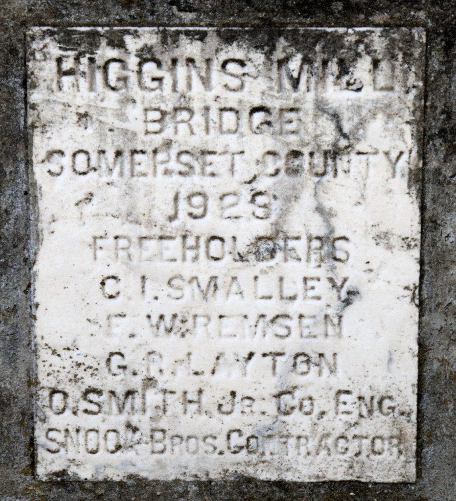
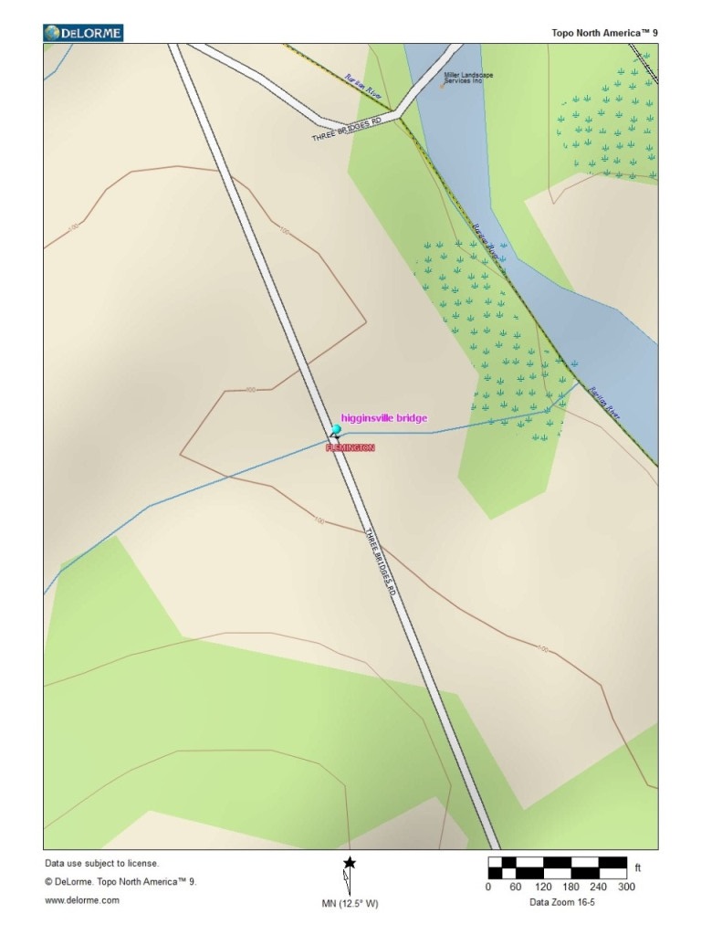
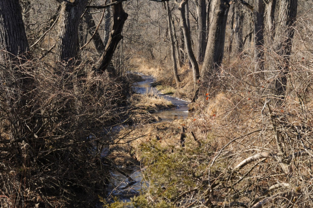
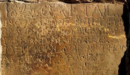
A plaque, inset in a concrete bridge constructed in 1923, spans the nameless stream, which now appears on the map as a thin blue line.The last image shows the stream as it exists today, just before it empties into the South Branch of the Raritan.
If all the water that ever flowed from the Raritan river drainage could be measured, its contribution to the depth of the ocean would be impressive. Think of that watershed as a collection agency for the world’s oceans.
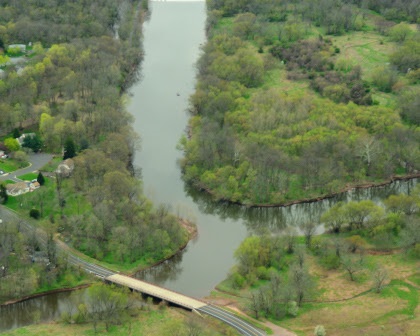
The South Branch flows into the confluence from the right, the North Branch from the left. They combine to form the Raritan River. This natural formation was an important landmark to the Lenape Tribe, which referred to this place as Tucca-Ramma-Hacking, “the meeting place of waters.”
An aerial view of the Raritan River clearly shows its two main branches, the South Branch and the North Branch. From the perspective of the confluence, its two main branches get their name, despite both arising north of their meeting place. The confluence marks the beginning of the Raritan River.
A closer look reveals the larger tributaries which feed the main branches; Rockaway creek, Black river/Lamington River and the Neshanic River, all of which are clearly noted on maps.
No less important are the numerous smaller brooks and creeks whose contributions are significant and whose names may appear only on old maps or engraved on marble plaques set in structures that bridge their banks. Peter’s brook, Chambers brook, Pleasant Run, Prescott Brook, Assicong Creek, Minneakoning Creek, Holland Brook and the First, Second and Third Neshanic Rivers, are identified on some maps though only Holland Brook has one sign along its nine mile winding course. Hoopstick and Bushkill are lesser known streams, within plain view, that bear no identifying signage and are often represented as nameless blue lines.
There are dozens more minor streams whose names appear nowhere except in obscure archives. Each one eventually feeds not the Raritan or its two main branches above the confluence. Knowing someone’s name is a sign of respect.
Calling someone by the wrong name can be embarrassing. However, the signs that misidentify the North Branch of the Raritan River as the Raritan River proper, have failed to embarrass those responsible for posting such signs.
Many smaller seeps and springs whose names have been lost to the ages add to the accumulated flow. Driving along the Lamington River for instance, there are endless watery traces arising from springs within the woods that empty into larger tributaries. Many are just moist creases worn through the soil over time, which collect rainwater and snowmelt to supplement the downstream daily flow.
Maps show endless springs, which make the cartographers final draft as thin blue lines. Often a network of converging shorter lines, each with a defined beginning, join to form larger streams like Pleasant Run and Holland brook.
Obscure water sources fascinate me simply because their anonymity and remote locations arouse my curiosity about the natural communities that might exist in such rarely visited places. Their presence represents a convergence of habitat types that attract birds and wildlife. Though they bear no labels to honor their faithful contribution to the next blue line and ultimate confluence, their importance must not be overlooked.
Many springs which appeared on old maps, no longer exist, eliminated by construction of sewer lines or otherwise diverted or filled in. As maps are revised and generations fade, these streams exist only in a cartographer’s archive.
My appreciation for these disappearing thin blue lines was heightened when I recently discovered that as a kid I walked over Slingtail brook every day on the way to school. At some point this little stream which bore a name, was diverted through a sewer line under the pavement. More amazing, even older residents had no memory of that stream, its presence and name lost to the ages. I did find a reference to Slingtail Brook in the Woodbridge, New Jersey newspaper archives dated 1939. The property through which a portion of the stream flowed was up for sale. A clause by the seller stipulated the brook not be diverted or covered over.
“Conveyance will be made subject to the following condition: That the course of Slingtail Brook as now existent, be not changed or diverted from its course or that said stream and flow of water therein be not blockaded, dammed or otherwise restricted.
Take further notice that the Township ………… “
Fords Beacon, May 12, 1939”
Somewhere in time the requirement that Slingtail remain unmolested, was lost to progress and legal wrangling. Such is the fate of so many smaller streams, especially when their names only exist in oral history and no signage marks there presence.
One small trickle of a stream that has miraculously retained its nature and name, is Cattail Brook.
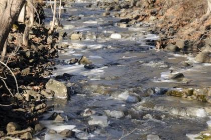
Cattail brook arises from a convergence of network of bubbling springs, supplemented by runoff from rain and snowfall. It begins as hardly more than a trickle, directed by gravity, from the south facing ridge of the heavily wooded Sourland Mountains, near East Amwell, NJ. Cattail brook gives birth to Rock Brook, a tumultuous and moody stream that joins the more sedate Bedens Brook on its way to the Millstone River. The Millstone joins with the Raritan River to make its final contribution to the earth’s deep blue oceans.
Rock Brook derives its character from the influence of gravity and its bed of stone, which can change its mood from this idyllic mountain brook into a raging torrent
An extended winter freeze, preserving snow from a previous storm beyond its expected stay, was interrupted by a thaw and heavy rain. The melting snow joined the torrential downpour as it flowed over frozen ground to collect in every shallow crease leading to the river. The water’s velocity was enhanced by the decreasing gradient of deep well worn pathways etched into the earth.
The banks of successfully larger streams barely contained the accumulation of water delivered from the network of anonymous thin blue lines. Acting as a single entity, the collection agency, if you will, of the Raritan River drainage, faithfully delivered its contribution of sweet water to the world’s salty oceans.
The Raritan River becomes the Raritan Bay downstream of the New Jersey Garden State Parkway Bridge. With a poetic flourish, the salt water bay and lower Raritan River are stained blue, saturated with the blue ink used to represent the thousands of nameless pale blue lines drawn on maps of the extensive Raritan River watershed.
Author Joe Mish has been running wild in New Jersey since childhood when he found ways to escape his mother’s watchful eyes. He continues to trek the swamps, rivers and thickets seeking to share, with the residents and visitors, all of the state’s natural beauty hidden within full view. To read more of his writing and view more of his gorgeous photographs visit Winter Bear Rising, his wordpress blog. Joe’s series “Nature on the Raritan, Hidden in Plain View” runs monthly as part of the LRWP “Voices of the Watershed” series. Writing and photos used with permission from the author.
Photos and article by LRWP Board President Heather Fenyk
The LRWP and EARTH Center of Middlesex County monitor for Fecal Coliform and Enterococcus at six non-swimming public beach access sites along the Lower Raritan during the warmer summer months. Fecal Coliform and Enterococcus are indicators of disease-causing bacteria in our waterways.
The EPA recommends that a single Enterococcus sample be less than 110 Colony Forming Units (CFU)/100mL for primary contact. Enterococci levels are used as indicators of the possible presence of disease-causing bacteria in recreational waters. Such pathogens may pose health risks to people fishing and swimming in a water body. Sources of bacteria include Combined Sewer Overflows (CSOs), improperly functioning wastewater treatment plants, stormwater runoff, leaking septic systems, animal carcasses, and runoff from manure storage areas. Enterococci levels are often high after heavy or consistent rainfall.
This week our South Amboy and Perth Amboy sites look great. Things are not so great at our Piscataway, New Brunswick, Edison and Sayreville sites – Enterococcus CFUs are quite high. Please note that these results for August 20, 2020 are preliminary and awaiting Quality Control.
Field Notes
Warm and muggy day for pathogens sampling. LOTS of bunker at the Edison Boat Basin and Sayreville Ken Buchanan Boat launch sites. Red tide and dead crabs in South Amboy. Special thanks to Maya for all her help monitoring this summer – today was her last day in the field before she heads back to school.
Look! Bunker/Menhaden! We saw lots of these guys at both our Sayreville (pictured) and Edison sites.Dead crabs and red tide at the South Amboy beachThis week we dropped our samples off in Bayonne at a monitoring site for the Hackensack Riverkeeper – they have great views of Elizabeth, NJ’s working port!
Summer 2020 Raritan Monitoring Sites
The New Jersey state Department of Environmental Protection and Middlesex County Health Departments typically monitor at sanctioned public swimming beach sites. They do not monitor the water quality for pathogens at public access non-swimming beach sites along the Raritan, despite regular use of these areas for primary contact (fishing and swimming) by members of our urban communities.
The LRWP works with in partnership with the Interstate Environmental Commission for lab analysis of our samples. We have a Quality Assurance Protocol Plan (QAPP) approved by the federal Environmental Protection Agency. We work to report our results as soon as lab analysis is completed.
Who will take home the title of Raritan Queen or Raritan King?!
The LRWP Board of Directors invites you to show off your knowledge about the Raritan River and the larger Raritan Watershed during our first ever RARITAN RIVER TRIVIA NIGHT!
Please join us Tuesday June 30, 5:30 pm via Webex for a friendly competition and conversation with David Tulloch and other members of the LRWP Board.
History, geology, geography, flora, fauna – it’s all fair game.
We guarantee that even if you think you know it all, you’ll learn a lot!
Photo: Alison M. Jones, NoWaterNoLife, taken during a LightHawk, Inc. flight April 19, 2019
Interview by Emily Koai, LRWP Spring 2020 Raritan Scholar
Johnny Quispe, born and raised in New Jersey’s Hackensack Watershed (Hudson County), started his B.S. at Rutgers – New Brunswick in 2009, then returned in 2014 to pursue a masters in Ecology. Johnny is now working on his doctorate in the lab of Jean Marie Hartman, an associate professor of Landscape Architecture. Through Professor Hartman, Johnny met Heather Fenyk, Board President of the Lower Raritan Watershed Partnership, and began collaborating with the LRWP on Raritan River-focused research. Johnny joined the LRWP Board in 2019 with the goal of expanding on his passion for advocacy for the river through community outreach. His current outreach involves work in South River and Sayreville on the South River Ecosystems Project, which has evolved through support from a diversity of stakeholders. Johnny recently secured a $249,000 National Fish and Wildlife Federation grant for project preliminary design and site assessment for the South River Ecosystem Restoration & Flood Resiliency Enhancement Project. Johnny seeks to guide this project through design to ultimately improve public access to the Raritan.
EK:Could you tell us a little bit about yourself and your background?
JQ: I first came to Rutgers in 2009 and wanted to pursue environmental policy. In addition to learning about local, municipal and federal policies, I started interning at a local non-profit, Edison Wetlands Association (EWA). That advocacy experience really helped me see policy play out on the ground. I attended a Coastal Estuarine Research Federation conference which opened my eyes to how sea level rise is going to impact wetlands. I decided early on to focus my studies on the Raritan and Raritan Bay, looking at the impacts that sea level and a changing climate has on, not only coastal ecosystems, but coastal communities.
I returned to Rutgers in 2014 to work under Jean Marie Hartman, starting a masters in ecology, the study of an organism and its interactions with its environment or with other organisms. I saw this as another way of looking at the world. Jean Marie really let my imagination fly. She gave me the opportunity to work on several projects with her, on all ranges of things. That’s when the connection between the importance of wetlands and what I had been advocating for in my internship really came together.
EK: Your research explores the relationship between sea level rise (SLR) and coastal wetlands and its impacts on the vulnerabilities of coastal areas. Is there anything specifically about the subject that you wanted to communicate to a wider audience?
JQ: There are many ways in which we can perceive risk. Sometimes we look at things one-dimensionally. When we look at coastal ecosystems we use different lenses: an environmental lens, a natural resource lens, and sometimes in terms of zoning. So how can we look at development and create positive opportunities for communities to build themselves up? How do we identify and prioritize these locations and bring more attention to these areas?
Sea level rise is not created equal. There are areas that are more at risk than others. This is subject to change as we continue to make decisions which can accelerate this change in sea level. As a society, we can start making significant changes. Some of these impacts may take a little longer to become realized, so we need communities, municipalities, the state, and federal government to all start thinking with a longer-term lens.
This means that planning boards and town councils should take a long range view of zoning: not just 10 or 20 years. 30 years is often seen as the lifetime of a structure, but you see even that expanding. How are we preparing for 2050 and beyond?
Everyone else’s risk is still kind of the same if municipalities put resources into their own municipal boundaries. Sometimes that is shortsighted. Taking a watershed or regional view to partner with other municipalities and the state, you can design projects that have more lasting impacts. There has to be cross pollination between our municipalities, and lead efforts by the state, to take a step up and organize at the larger, landscape scale.
EK:How have you directly encouraged policy-makers, municipalities, and individuals on the path of enhancing their own roles?
JQ: Experts at all levels need to listen to people. We need to listen to what the needs are. That is where you’ll find all the information you need about a location. I think, as well intentioned as researchers, government officials, and others may be, sometimes they make change without consulting the people that change is going to affect. Understandably, this leaves a sour feeling with the community.
Having buy in from stakeholders is important. I meet with community members, stakeholders, folks from different nonprofits in the area, and people from different settings. I think everyone has a stake in it, so they want to be part of the process. If you eliminate the possibility for groups to be part of planning, they ultimately feel that they’re being subjected to the change. Sharing these ideas in public meetings that are accessible and allowing participation is important.
As we continue to see these impacts in coastal communities across the US, these are the kind of processes that are going to have to happen. Otherwise we have unsolicited buybacks and changes being made without much buy-in from the community. You’re going to have a lot of pushback and a lot of people who are unhappy.
EK:Is there anything you think is key to trying to get the whole process to come together?
JQ: I think researchers or officials looking to make changes really need to embed themselves in the community—to be part of that community, otherwise you’re just going to be seen as the third party coming in and telling the community what’s best for them.
I’ve been working in the Lower Raritan since 2009, and have established relationships that have blossomed into my current projects. My time working in a local non-profit really allowed me to meet all the non-profit stakeholders and people who have been fighting to make the Raritan a better place for the last 20-30 years.
I think what everyone needs to do is find a champion—someone who they can align themselves with to help them push some of these ideas forward. If you’re not part of the community, who is part of the community, and how can you work with that person to really get the facts and get the message out there? That’s what’s really key. My hope is to identify champions along the east coast who can really get these kinds of projects started. I see myself more as a bridge-builder—someone who is bringing people together, really letting some ideas simmer and take them and try as much as I can, with the help of others, to bring those to fruition.
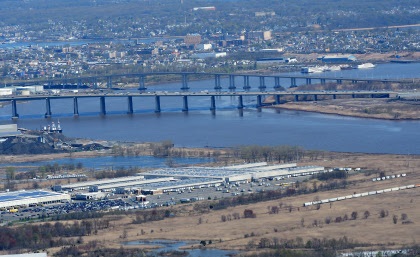
One of many Raritan River-adjacent landfills/Superfund sites at-risk of flood impacts Photo by Alison M. Jones, No Water No Life – taken during a LightHawk flight, April 2019
On Tuesday May 12, 5:30-6:30 pm join Heather Fenyk with the Lower Raritan Watershed Partnership, Alison M. Jones with No Water No Life, and Joe Mish (aka Winter Bear Rising) author of the LRWP series “Nature on the Raritan, Hidden in Plain View” for a virtual tour of the Raritan Basin.
During this hour long tour Heather, Alison and Joe will share and discuss images taken during a LightHawk flight on April 2019. With many thanks to LightHawk, Inc. for the experience – we look forward to sharing some the experience with you.
This was a very special flight. We expect it to be a very special conversation.
Volunteers will help project coordinators with sample collection, sample preparation and delivery, and analysis. See here for more info on our monitoring program.
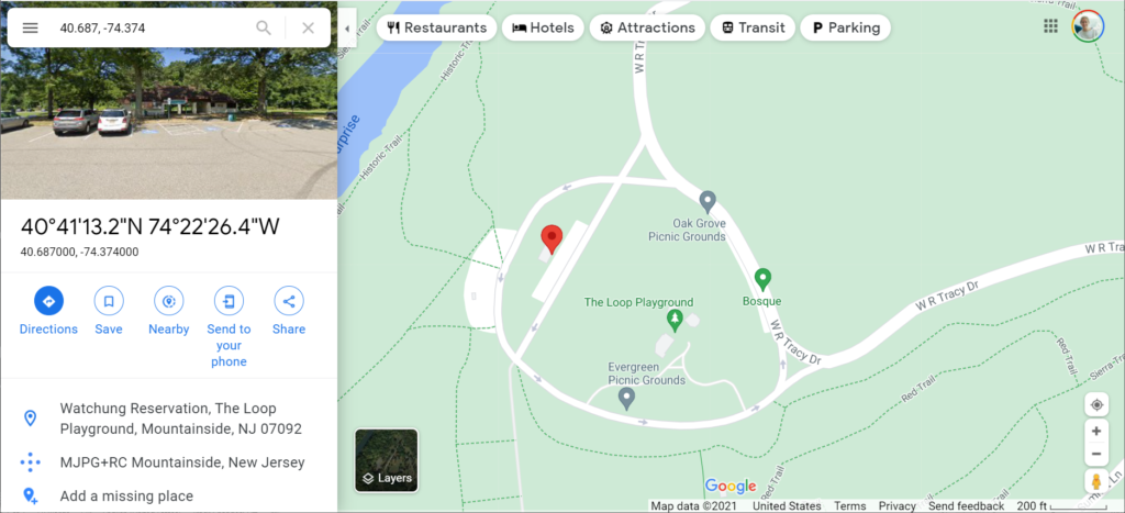
Registration is now open for the LRWP’s first “Watershed Highlights and Hidden Streams” walking tour of 2021!
Join us on Saturday July 24, 10-noon as we visit one of the northernmost areas of the Lower Raritan Watershed and explore the Watchung Reservation’s Blue Brook and Lake Surprise.
The walk, guided by our own David Tulloch, will help our hikers begin to discover this massive Olmsted Brothers-designed park. With help from a few maps, Dr. Tulloch will talk about the context of the park within the watershed as well as the context of this culturally-significant historic landscape within the surrounding communities of Union County.
We will be meeting in the Watchung Reservation at the area called The Loop (Some park signs point towards the Loop and its playground). At 10am our group will depart on foot from the building (with bathrooms) shown with the red marker below (40.687, -74.374).
Estimated 4 miles of walking.
Registration required. Please check the LRWP website for updates, especially in the case of inclement weather.
The Watchung Reservation is in Scotch Plains, NJ 07076