**Please note date change**
For our March 12 general meeting, in recognition of the 2018 World Water Day theme of “Nature for Water,” we have asked Rutgers Professor JeanMarie Hartman to present on “The Role of Forests as Green Infrastructure.” As part of this presentation, Professor Hartman will provide an overview of a proposal to reforest vacant lots in Perth Amboy as a way to manage combined sewer overflow events.
The design suggestions will be compared to current best management standards and practices. Discussion will also elucidate several points regarding the relationships between human and natural systems such as resource conservation, habitat restoration and creation, and urban ecology.
The meeting will be held from 10-noon in the Middlesex County Planning Offices at 75 Bayard Street, New Brunswick, NJ – 5th floor mid-size conference room.
Parking is validated for those parking on floors 5 and higher in the RWJ Wellness Parking Deck located at 95 Paterson Street, New Brunswick, NJ 08901. Be sure to bring your ticket to the meeting for validation.
For more information contact Heather: hfenyk AT lowerraritanwatershed DOT org
Please join us for our May visual habitat assessment training with the LRWP and WMA9 Americorps Watershed Ambassador Rob Hughes! (Here’s more on the LRWP’s water quality monitoring programs).
This FREE training on Saturday May 5 will run from 9 AM – 1 PM at the Middlesex High School, located at 300 John F Kennedy Dr, Middlesex, NJ 08846
We will start the morning with a lecture indoors, and then get out in the field to test our knowledge of streams and stream habitat.
Please wear clothing and footwear that you don’t mind getting wet and dirty.
RSVP required, E-mail Rob Hughes: wsamb@raritanbasin.org

~VOLUNTEERS NEEDED~ Please join the LRWP, our Americorps Watershed Ambassador and community partners including Friends of Mile Run Brook, Greater Brunswick Charter School, Esperanza Neighborhood Project, the New Brunswick Environmental Commission, Elmwood Cemetery and the New Brunswick Department of Public Works for a multi-site clean-up of Mile Run Brook, culminating in a community celebration in Boyd Park!
WHAT: a clean-up of Mile Run Brook, followed by a community picnic and celebration
WHEN: Saturday May 12
9:00 AM to noon – clean-up of multiple sites.
12-1:30 pm community gathering / picnic in Boyd Park.
WHERE: Multiple sites in New Brunswick
Site 1: Friends of Mile Run Brook / Corner of Hamilton Street and Woodbridge Street

Site 2: Esperanza Neighborhood Project / Corner of French Street and Sandford Street

Site 3: Greater Brunswick Charter School (closed group)

Site 4: Elmwood Cemetery / Entrance at Commercial Avenue
Please wear closed toe shoes and clothes you are willing to get wet and dirty. Gloves and bags will be provided!
WAIVERS
5.12.2018 MRB clean-up waiver, English
Permission and rights granted to LRWP to record and use image and voice, English
For more information
Heather: hfenyk AT lowerraritanwatershed DOT org
or Americorps Watershed Ambassador Rob Hughes: wsamb AT raritanbasin DOT org
Article and photos by Joseph Mish
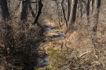
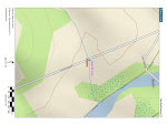
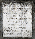
A thin blue line drawn on a map, comes to life in this photograph. A plaque, inset in a concrete bridge spanning the stream, constructed in 1923, a map showing a thin blue line depicting the stream and an image of the stream as it exists today just before it reaches the South Branch.
If all the water that ever flowed from the Raritan River drainage could be measured, its contribution to the depth of the ocean would be impressive. Think of that watershed as a collection agency for world’s oceans.
An aerial view of the Raritan River clearly shows its two main branches, the South Branch, and the North Branch. The South Branch draining more area than the North. The confluence of the North and South branch mark the beginning of the Raritan River.
A closer look reveals the larger tributaries which feed the main branches; Rockaway creek, Black River/ Lamington River and the Neshanic River, all of which are clearly noted on maps.
No less important, are the numerous smaller brooks and creeks whose contribution is significant and whose names may appear only on old maps or engraved on marble plaques set in the structures that bridge their banks; Peter’s brook, Chamber’s brook, Pleasant run, Prescott brook, Assiscong creek, Minneakoning creek, Holland brook and the First, Second and Third Neshanic rivers. Hoopstick, Prescott and Bushkill are lesser known streams, within plain view, that bear no identifying name.
There are dozens more minor streams whose names appear nowhere except on an obscure online list. Each one eventually feeds into the Raritan or its two main branches above their confluence. Knowing someone’s name is a sign of respect. Calling someone by the wrong name can be embarrassing. However, the sign that identifies the North branch of the Raritan as the Raritan River proper, has failed to embarrass those responsible for posting such signs.
Many smaller seeps and springs whose names have been lost to the ages, add to the accumulated flow. Driving along the Lamington, for instance, there are endless watery traces, arising from springs within the woods that empty into larger tributaries. Many are just moist creases worn through the soil over time, which collect rainwater and snow melt to supplement the downstream daily flow.
Maps show nameless springs, which make the cartographer’s final draft, as thin blue lines. Often, a network of converging shorter lines, each with a defined beginning, join to form larger streams like Pleasant run and Holland brook.
These obscure water sources fascinate me simply because their anonymity and remote location arouses curiosity. Their presence also represents a convergence of habitat types that attract birds and wildlife. Though they bear no labels to honor their faithful contribution to the next blue line and ultimate confluence, their importance should not be overlooked.
Many springs which appeared on old maps no longer exist, eliminated by construction of sewer lines or filled in. As maps are revised and generations fade, these streams exist only in a cartographer’s archive.
My appreciation for these disappearing blue lines was heightened when I recently discovered that as a kid, I walked over Slingtail brook every day on the way to school. At some point this little stream was diverted through a sewer line under the pavement. More amazing, even older residents had no memory of that stream whose name has been lost to the ages.
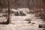
An extended winter freeze, preserving snow from a previous storm, beyond its expected stay, was interrupted by a thaw and heavy rain. The melting snow joined the torrential rain as it flowed over frozen ground to collect in every shallow crease leading to the river. The water’s velocity was enhanced by the decreasing gradient of deep well-worn pathways etched in the earth.
Where water barely trickled most of the year, a proportional biblical flood now ensued.
The banks of the successively larger streams barely contained the accumulation of water delivered from the network of anonymous thin blue lines. Acting as a single entity, the collection agency if you will, the Raritan River drainage, faithfully delivered its contribution of sweet water to the world’s salty oceans.

Cattail brook arises from the convergence of a network of bubbling springs, supplemented by runoff from rain and snow fall. It begins as hardly more than a trickle, directed by gravity, from the south facing ridge of the heavily forested Sourland mountains. The DNA extracted from a drop of water, taken from the deepest canyon in the ocean, would trace its lineage back to cattail brook through its genetic progeny. Cattail gives birth to Rock Brook, a tumultuous and moody stream that joins the more sedate Bedens brook on its way to the Millstone river. The Millstone brings its accumulated genetic material to blend with that of the Raritan to make a final contribution to the earth’s deep blue oceans.

We use our imagination as we await the technology that can trace the oceans DNA back up Cattail brook to show a single drop of morning dew that dripped from a box turtles face, was a critical contribution to the blue ocean we see via satellite images of the earth.
Rock brook derives its character from the influence of gravity which changes its mood from an idyllic mountain brook to a raging torrent.
Author Joe Mish has been running wild in New Jersey since childhood when he found ways to escape his mother’s watchful eyes. He continues to trek the swamps, rivers and thickets seeking to share, with the residents and visitors, all of the state’s natural beauty hidden within full view. To read more of his writing and view more of his gorgeous photographs visit Winter Bear Rising, his wordpress blog. Joe’s series “Nature on the Raritan, Hidden in Plain View” runs monthly as part of the LRWP “Voices of the Watershed” series. Writing and photos used with permission from the author.
Article by Quentin Zorn
My name is Quentin, and I am a junior at Rutgers studying environmental policy. Over the course of this semester, I have been interning with the Lower Raritan Watershed Partnership and have had the opportunity to work on a wide variety of projects relating to water quality issues. I participated in many stream cleanups, attended many exciting events such as the Raritan River Festival, got to contribute to several long-term art projects and learned a lot along the way. This experience has not only taught me a lot about watershed management, but also has broadened my way of thinking and strengthened my passion for combating environmental issues.
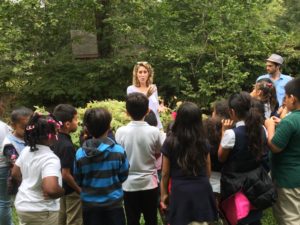
One of the more exciting projects I was able to participate in was teaching kids from the Plainfield Youth Center about water quality and watershed management, and to work on an art project with them. This was part of the Lower Raritan Watershed Partnership’s Project WADES Environmental Education curriculum. We started off by taking the kids to a nearby stream and training them in visual habitat assessments and how to notice what kinds of things can impair stream quality, such as nearby roads, maintained lawns and lack of riparian cover. We got to help build a foundation with these kids at a young age, which will help them understand and care about water quality issues as they grow up.
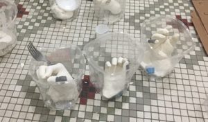
The art project we worked on with the kids was a lot of fun and interactive. Each kid selected a piece of trash found at a cleanup in the Lower Raritan Watershed, and then held that piece of trash in a container, which we would then fill with an algae-based mold called alginate.

The finished products were a bunch of unique sculptures of hands holding the trash.
When I was working on my own on this internship, I got to explore and contribute to several different datasets. I worked on a master database of every municipality in the Lower Raritan Watershed that contained a wide variety of information on each town’s environmental and development plans. I also worked with data from the New Jersey Department of Environmental Protection on different industries that have permits to pollute into the Raritan River, and I helped make this data more coherent and complete. This helped me understand what kind of information is important when considering water quality, and also my contributions helped make more complete and meaningful logs of data. It was really satisfying to see all this information come together and fulfilling to know that the public can access this data and learn what is going on in their watershed.

There were many cleanups of streams in the watershed throughout the duration of my internship, and I participated in as many as I could. The cleanups were far more rewarding than I anticipated them being. Arriving at any given cleanup gave me a feeling of hopelessness when I would see how much trash there was. I would think, “we can make this a little better, but it’s still going to be in a bad condition.” Every single cleanup I was surprised by how good of a job everyone did, and how great the area looked when we left. Seeing all of the trash piled up in the end was always shocking but felt good to have gotten it all out of the ecosystem.
On November 17 the Lower Raritan Watershed Partnership joined with NOAA to co-host a day-long workshop: “Introducing Green Infrastructure for Coastal Resilience”. This workshop, designed for planners, engineers and municipal leaders not yet familiar with GI for coastal resilience, brought in more than 50 participants from the Lower Raritan Watershed and throughout New Jersey. It was a great event!
Workshop participants brainstorm ways to implement Green Infrastructure in their communities
Many thanks to everyone who joined us for the workshop, with special thanks to our speakers: Lauren Long (NOAA), Toby Horton & Jeremiah Bergstrom (Rutgers Cooperative Extension), John Trucsinski (The Nature Conservancy), Linda Weber (Sustainable Jersey) and Carter Craft (Consulate General of the Netherlands).
Tobiah Horton (Rutgers Extension), Lauren Long (NOAA) and Carter Craft (Consulate General of the Netherlands) discuss local resilience responses
The workshop was timed to coincide with the 5th anniversary of Superstorm Sandy. We saw this anniversary as an opportune moment to reflect on successes in implementing GI thus far, as well as to frame challenges, solutions and opportunities for future GI interventions. Of course this work is just beginning. The LRWP, NOAA and Rutgers Marine Sciences are discussing how to continue the conversation in 2018. Stay tuned! For now, please see conference handouts, presentations, and additional resources below.
Participant Agenda:
Conference Handouts:
Presentations:
Notes:
Additional Resources:
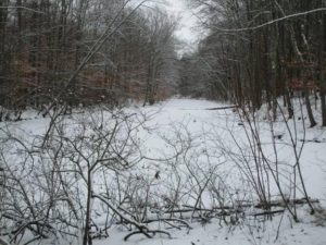
Article and photos by Joe Sapia
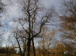
Soft morning sunlight contrasts with threatening skies at the high ground of Thompson Park in Monroe, Middlesex County.
A popular winter activity for generations at Thompson Park is sledding from the high ground toward the low ground around “Jamesburg Lake” (properly Lake Manalapan). The 30-acre lake is formed by the damming of Manalapan Brook at Jamesburg. Remember, there are few, if any, natural bodies of water on the Coastal Plain.
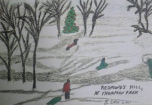
Sledding at Thompson Park in Monroe, Middlesex County, via my 2001 folk art Christmas card.
SNOWFALL: The Saturday, December 30, snowfall of 1.0 inch at my house in the part of Monroe between Helmetta and Jamesburg, Middlesex County, brought the season’s total to 9.0 inches. The seasonal average for New Brunswick, Middlesex County, about 7 miles away, is 25.8 inches. Elsewhere in the Midlands, according to the National Weather Service, with these readings based on what had been reported by reliable spotters at the end of the snowfall and perhaps not comprehensive: Burlington County: a high of 2.5 inches at Florence to a low of 1.5 inches at Moorestown; Hunterdon County: 1.0 inch in Lebanon to .8 inches at Whitehouse Station; Mercer County: 3.2 inches in Hamilton to 2.5 inches in Ewing; Monmouth County: 2.8 inches in the Howell area to .9 inches in Shrewsbury; Somerset County: 1.0 inch in Basking Ridge to .8 inches in Bridgewater; Ocean County: 3.3 in Jackson to 1.5 inches in Toms River.
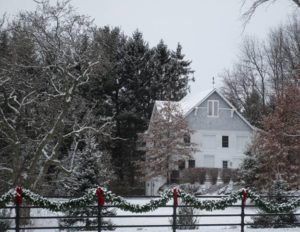
Main Street in Cranbury, Middlesex County, in the Saturday, December 30, snowfall.
Iced-over and snow-covered Devil’s Brook on the boundary of Plainsboro and South Brunswick, Middlesex County.
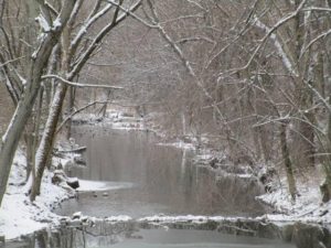
Cranbury Brook as it drains Brainerd Lake (“Cranbury Lake’) in Middlesex County.
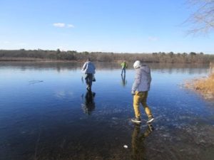
SAFE ICE: This time of year, and especially in the hard freeze the Jersey Midlands is in the midst of, we may be tempted to walk out on ice or go skating on it. Be careful! My rule of thumb is the ice must be at least 4-inches-thick. But various factors could come into play, such as warming temperatures, honey-combing, and running water. So, additionally, I look for crystal clear ice or blue-white ice. I am careful of melting ice, snow insulating ice, channels that may run through bodies of water, and fragile ice where water meets land or vegetation.
Anglers on an iced-over Helmetta Pond.
ICE SAFETY: If ice is breaking underneath, displace your weight by lying flat. For would-be rescuers, follow this order: throw (a line or flotation device), row (a boat to the person), go (yourself only as a last resort). Probably the soundest advice is to immediately seek help from expert rescuers.
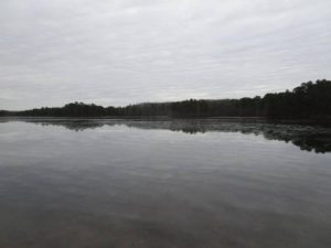
Prospertown Lake in Jackson, Ocean County. The lake is at the northern extreme of the main Pine Barrens.
SWAMP-WALKING: With the sub-freezing high temperatures for an extended period, this is what I look for — a good freeze of the swamps, allowing access to otherwise difficult places to get to. I love swamps!
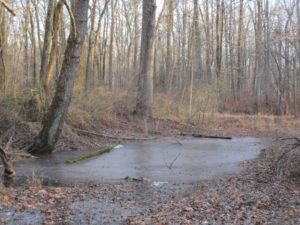
An iced-over wet area in the Manalapan Brook floodplain in Monroe, Middlesex County.
SWAMP-WALKING, No. 2: I started off into the woods across the street from my house – in the Pine Barrens of Monroe, Middlesex County – to do some swamp-walking in the Manalapan Brook floodplain. I did do some, but I got sidetracked when I noticed the abundance of winterberry, genus “Ilex.” I did not get around to making a Christmas wreath or swag, which I decorate with winterberry, but I wound up gathering winterberry to display on its own. I came home with a nice bundle. (To conserve, I broke only one branch from each selected bush.)

Winterberry from the swamp hardwood forest of the Manalapan Brook floodplain on display on my antique kitchen table.
SNOW GEESE: I finally saw some snow geese, “Chen caerulescens,” down from the Arctic as I was driving along the Mercer County-Middlesex County boundary on the border of East Windsor, Cranbury, and Monroe. They were easy to identify by their white bodies and black-tipped wings. There were only a few, rather than a flock. I took a few minutes to see if they were joining a flock on some farmland, but I was going to work and had limited time, finding nothing in my quick search.
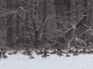
Canada geese, “Branta Canadensis,” is a snow-covered field in South Brunswick, Middlesex County.
ATLANTIC OCEAN TEMPERATURES: The Atlantic Ocean temperature at Sandy Hook on December 30-31 weekend ranged from about 30 to 35 degrees.
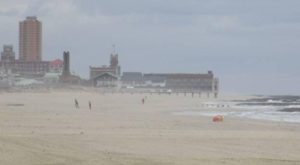
A quiet December Atlantic Ocean beach, looking from Avon-by-the-Sea to Asbury Park, Monmouth County.
MOON: The next full moon, the Full Moon After Yule, is January 1, New Year’s Day.
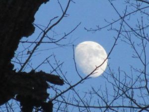
The near-full moon over the swamp hardwood forest of the Manalapan Brook floodplain in Monroe, Middlesex County.
SUNRISE/SUNSET: For Sunday, December 31, to Saturday, January 6, the sun will rise about 7:20 a.m. and set about 4:35 to 4:40 p.m. For Sunday, January 7, to Saturday, January 13, the sun will rise about 7:20 a.m. and set about 4:45 to 4:50 p.m.
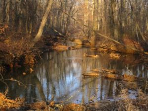
Soft sunlight on Manalapan Brook in Monroe, Middlesex County, as it flows toward Helmetta and Spotswood, also in Middlesex County.
Joe Sapia, 61, is a lifelong resident of Monroe — in South Middlesex County, where his maternal family settled more than 100 years ago. He is a Pine Barrens naturalist and a gardener of organic vegetables and fruit, along with zinnias and roses. He draws inspiration on the Pine Barrens around Helmetta from his mother, Sophie Onda Sapia, who lived her whole life in these Pines, and his Polish-immigrant grandmother, Annie Poznanski Onda. He gardens the same backyard plot as did his Grandma Annie and Italian-American father, Joe Sr. Both are inspirations for his food gardening. Ma inspires his rose gardening. Joe is a semi-retired print journalist of almost 40 years. His work also is at @JosephSapia on Twitter.com, along with Facebook.com on the Jersey Midlands page.
Copyright 2017 by Joseph Sapia
In November the New Brunswick Community Arts Council invited the Lower Raritan Watershed Partnership to participate in the inaugural “Windows of Understanding: We see through Hate” project. Windows of Understanding seeks to:
• Counteract the negativity and hate perpetuated in the headlines – by installing community art interventions that illustrate the compassion and love being exercised around us.
• Promote awareness about the vast array of social justice issues being addressed in New
Brunswick, connecting organizations with the wider community and each-other.
• Transform our “Main Street” spaces into literal windows of understanding.
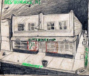
The LRWP was paired with Kim’s Bike Shop (111 French St, New Brunswick, NJ 08901). Working with Kim’s and our coLAB Arts National Endowment for the Arts resident artist Jamie Bruno, the LRWP has developed “Listen to your neighbor, listen to the land” – which will be installed at Kim’s from January 15-February 28. “Listen to your neighbor, listen to the land” reflects the way the LRWP sees through hate as well as the way we hope to connect to our communities. The installation incorporates shoes filled with soil and plants. The shoes represent people, travel, and change. The soil represents our origins in the land.
From Jamie Bruno’s artist statement:
Across religion, race and culture we all spring from the earth and its water and soil. The plants give hope for survival and sustenance: hope to grow new roots and make new connections. The title asks the viewer to listen to their neighbors over the din of every day life. Our neighbors are people who live near us. People who live on the land we live on, yet whose stories we often do not know. In urban environments it can be difficult to know land too, yet she is everywhere: Under the pavement, in the water we drink, in the air we breathe.
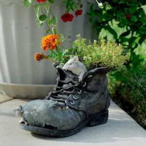 • The shoes represent the human element, the “neighbor” through travel, labor and economic change in addition to empathetic connection across class, race and culture; an admonition to “walk in another’s shoes.”
• The soil represents land: absorption, filtration, and contamination. Soil health effects human health though the quality of our fruits and vegetables as their roots gather nutrients and the quality of the water in our watersheds as water either filters slowly through healthy soil becoming clean or flows quickly above compacted soil carrying waste.
• The plants represent the hope to grow new roots in new places and to make new connections. Plants store and slow water as it moves through the landscape, further cleaning it, thereby increasing the landscapes inherent value to local wildlife and to neighbors, whether they pass through or decide to stick around and plant their own seeds.
The LRWP and Kim’s invite you to join us from 2-4 PM on Monday January 15, 2018 for the “unveiling” of “Listen to your neighbor, listen to the land” and for refreshments. We will be outside in front of the store planting milkweed for participants to take home, and handing out seed packets for summer gardens.
For more information contact Jamie Bruno: jamie@colab-arts.org
Article and photos by Joe Mish

A Red fox fills out a page in its daily diary, handwritten in the fresh snow along the South Branch.
The thirty-one days allotted to January on the calendar is only a suggestion, as far as that month is concerned.
January arrived ahead of schedule this December in a fit of impatience at the slow start of winter. The dull cold and dark days that prefaced winter’s birth seemed to stall the arrival of January and the blistering pace of expanding daylength and razor sharp cold.
As December reflected on the satisfaction of delivering twins, in the form of winter and light, the cold, wind and snow remained idling in the dark, awaiting a new leader. January came to the rescue as it honed the sharpness of the cold to a razor’s edge with forceful arctic wind, in whose draft, daylight was pulled along at an accelerated pace.
The whirlwind that is January never rests as it constantly delivers snow and light wrapped in cold and often spiced with biting wind.
Despite being scheduled for 31 days, January makes the time fly along with everlasting snow and does its best to co-author February weather.
In an attempt to freeze time so it can linger longer than scheduled, January’s frigid breath turns the river’s surface into a crystal lattice of solid ice. Impressive, but not miraculous and arguably unintended.
It is actually possible to watch January at work as it arranges hydrogen and oxygen atoms into a three-dimensional arrangement as it forms ice. A fast-moving cold front dropped the temperature below freezing. The river water was already cooled to 38 degrees and colder in the shallow eddies along the shore. As I fumbled with my camera I noticed ice forming along the edges of one pool. Crystals began to grow from a branch, mid pool, as well as the edges. When I looked again a few minutes later, the ice had expanded several inches. It was like watching a time lapsed movie where time is condensed from hours to seconds. However, this was happening in real time. I was amazed how quickly ice was forming. Crystals grew especially fast from three different areas. Two looked amazingly like feathers, one mimicked a large bird feather while the second looked so much like the cut feather used to fletch an arrow. The third crystal was an exact image of a starburst, where five pointed spikes began to outgrow the shorter but expanding tines. I stared in amazement as the ice images grew before my eyes as if watching an artist at work. The arrow feather magically turned into the body of what I imagined to be a grouse. The other feather grew into the body of some other large bird, the intricacies of each quill carefully detailed. Ice grew from the edges until the sheltered water had been completely sealed with a plate of fine transparent etchings. Though the artist was invisible, evidence of his existence was apparent.
January may seem harsh at times but all life has evolved to cope with its overly enthusiastic nature. As a concession, January snow provides a comment section for life along the river to tell their stories. Even the wind has the opportunity to take a single blade of grass and delicately etch its thoughts into the blank white slate.
A gray fox reveals its path and daily activity, as if written in an open diary, from the moment it left its sheltered nook to the strategy used to capture a tasty vole and the heart of a January love interest.
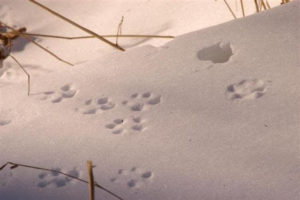
Fox tracks in the new snow with strands of straw colored grass bathed in the contrast of subtle light changes would make a fine Christmas card from the fox. The tracks convey a signed message that translates even to those who aren’t conversant in the language of ‘fox’.
A page purloined from the fox’s diary reveals its thoughts and activity written in the January snow. The fox stopped here atop a snowdrift to scan the area ahead for a meal or a mate, whichever came first.
Loathe to depart, January wills its wintry legacy to February who politely accepts it to bolster the enthusiasm of the fading winter.
December is as far as the year will take us, though fear not, January awaits holding the door to a new year wide open with a welcoming ice cold wind to ensure we enter fully awake and energized.
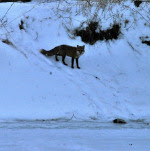


A red fox is a magical creature but even a fox cannot walk on water unless January turns it into a crystal lattice. This fox crosses the river, lured by the siren call of a potential mate.
Author Joe Mish has been running wild in New Jersey since childhood when he found ways to escape his mother’s watchful eyes. He continues to trek the swamps, rivers and thickets seeking to share, with the residents and visitors, all of the state’s natural beauty hidden within full view. To read more of his writing and view more of his gorgeous photographs visit Winter Bear Rising, his wordpress blog. Joe’s series “Nature on the Raritan, Hidden in Plain View” runs monthly as part of the LRWP “Voices of the Watershed” series. Writing and photos used with permission from the author.
Help us kick-off the New Year by giving some clean-up attention to Middlesex County’s Johnson Park (Piscataway). Since we last cleaned that area a pair of Bald Eagles has moved in! We’ll stay clear of their nesting grounds, but there is plenty to do in the rest of the floodplain. We will meet 9:30am at the Middlesex County Parks Department offices, and from there caravan to the clean-up site.
WHAT: a clean-up of Johnson Park on Sunday January 14 from 9:30 AM to 11 AM (cutting things short because of the nip in the air)
WHERE: Clean-up kick-off at 1030 River Road in Piscataway, Middlesex County Parks Headquarters lobby.
PLEASE NOTE: if there is snow on the ground on January 14, we will have to postpone the clean-up. (Its hard to find litter when you can’t see it!) – check on the event webpage to verify
This Event is co-coordinated by the Lower Raritan Watershed Partnership and the Middlesex County Department of Parks. With special thanks to Middlesex County for cartage and supplies.
Please dress appropriately for the weather. Gloves and bags will be provided!
*** For more information contact Heather hfenyk@lowerraritanwatershed.org ***