During one, six thousand year moment, in the eons of glacial expansion and retreat, the Queen of Rivers was born. So described by an early nineteenth century writer, inspired by the bucolic Raritan River. The beauty of the river’s pastural floodplain dotted with colorful native flowers and grasses, stood in contrast to the intermittent high, red shale cliffs. Spring floods scrubbed the red shale soil from its banks to turn the raging river into a semi solid crimson torrent. The contrast in color is dramatic where gravel lined upland streams tumble into the main river current.
From sweet water freshet to the brackish tide water of its bay, the Raritan’s unimpeded flow expressed its seasonal moods in uninhibited water-colored brush strokes across the landscape, as if it were a living canvas.
So, the Raritan River proper, as it is defined today, deserves the recognition of a natural wonder, a reference point in geological history, worthy of attention in a state marked by an ever changing manmade landscape.
The Raritan’s headwaters arise from two major sources in the north, the South Branch from Budd Lake, and the North Branch from a swamp in Chester. The confluence of these two rivers join (in Branchburg) to form the Raritan River.
Facing upstream at the confluence, the river on the left enters from the south and is so named the South Branch, despite its origin in the north. The river on the right comes in from the north and is aptly named the North Branch.
If ever a natural wonder needed to be celebrated it would be the Raritan River. Toward that end I always imagined a rough stone marker of an age befitting the river queen’s origin be placed at the confluence, “the meeting place of waters”, Tuck-ramma-hacking”. Informal and primitive to match the uninhibited behavior of this ancient watercourse, a perfect partner to mark the celebrated river’s place of birth: a monument that will be submerged during spring floods and bear the scars of ice flows.
I imagine a bronze plaque bearing the name of the river and its birthdate set among petroglyphs of animal tracks and wild flowers carved into the stone by local artists to represent the community the river serves.
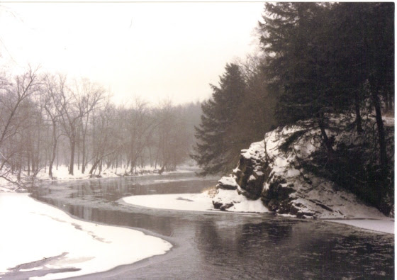
The spot for eventual placement of a “birthplace of the Raritan” marker
Bringing a dream to reality often turns to fantasy. At least now an attempt is being made to explore the possibility of placing such a stone at the apex of the North and South Branch Rivers. Through a network of well-placed friends, we have approached the state with this request to determine feasibility. A labyrinth of permits and permissions remains to be navigated if given conditional approval. At the very least, the ship has left the dock and we will soon learn if it is seaworthy.
A stone, not yet chosen, has been promised and placement will be included. The river deserves to have a name and birthstone. Erroneously, the North Branch has official signage that declares it to be the Raritan River. If nothing else, it would be a worthy accomplishment to establish the correct identity.
“Like a pine tree linin’ the windin’ road, I’ve got a name, I’ve got a name…..” go the lyrics to a song. What is in a name is respect. It is our nature to treat anonymity differently than familiarity. Walk through a field, not knowing one plant from another, go from point A to point B and we naturally take a straight-line course. Eyes planted on the far side, anything in the way gets stepped upon. Guarantee that if a plant is identified to the trekker, whether it be fleabane or little bluestem, the path will be adjusted to avoid stepping on the now identified plant. So it is with names that emerge from anonymity, they project some kindred link that brings conscious thought to bear. A good reason to identify the Queen of Rivers and engender some new found respect for a natural wonder that will be here after we and our kin are long gone.
Author Joe Mish has been running wild in New Jersey since childhood when he found ways to escape his mother’s watchful eyes. He continues to trek the swamps, rivers and thickets seeking to share, with the residents and visitors, all of the state’s natural beauty hidden within full view. To read more of his writing and view more of his gorgeous photographs visit Winter Bear Rising, his wordpress blog. Joe’s series “Nature on the Raritan, Hidden in Plain View” runs monthly as part of the LRWP “Voices of the Watershed” series. Writing and photos used with permission from the author. Contact jjmish57@msn.com.
Balance open space purchases using County funds with housing offsets to address affordable housing crisis
The OSRP calls for acquisition of land zoned for residential development to preserve farmland and open space, however it does not contain provisions for the off-setting of these purchases with requirements for participating municipalities to increase their residential zoning density or extent. We are concerned that if adopted as currently configured, the OSRP will lead to additional upward price pressure on remaining residentially-zoned undeveloped land, ultimately translating into even higher housing costs and exacerbating the ongoing housing crisis already documented in Middlesex County’s Destination 2040 Master Plan.
We suggest that to mitigate this unintended consequence of two Destination 2040 objectives working against each other the OSRP should require those municipalities receiving Middlesex County Open Space to densify or expand their residential zoning to completely compensate for the reduction in potential buildable units resulting from farmland and/or open space purchases. These offsets should consist of at least a ratio of one created zoned housing unit for every purchased developable housing unit, but with additional credits extended toward housing set-asides for affordable housing, micro-housing, homes for veterans, and age-restricted units.
Contextualize recreational connectivity within the larger region
Any County Greenway considerations should include examination of large-scale network connections for recreation, specifically opportunities to link to multiple East Coast greenway networks via the Middlesex Greenway, the Delaware & Raritan Canal, and the Intracoastal Waterway. The larger metropolitan areas of New York City and Washington D.C. are roughly framed by the Appalachian Trail to the North and the potential alignment of the East Coast Greenway to the South. In addition, the Hudson River Valley to the East, the Delaware and Lehigh National Heritage Corridor, and the Chesapeake and Ohio Canal to the west all form a larger regional trail system matrix. The Middlesex Greenway and Delaware & Raritan Canal could serve as major junctions for these larger regional networks. Likewise, supporting Blueway access from the Intracoastal Waterway up the Raritan River inland to Middlesex County could strengthen a weak link in the East Coast Blueway system.
Contextualize habitat connectivity within the larger region
Any analysis of ecological habitat and habitat needs must start with a larger perspective. No mention is made within the current OSRP of watershed level planning, migratory behavior linked to flyways and swimways, or other larger ecological planning efforts like those developed by the New York-New Jersey Harbor Estuary Program.
Similarly, as the Middlesex County border is so often defined by natural landscape features including watershed ridges and waterways that serve as habitat connectors, opportunities to enhance habitat connectivity must be examined within the additional contexts of neighboring County conservation and preservation efforts.
Present more detailed analysis of use of Middlesex County Conservation/Preservation areas
The current OSRP provides solid summary and analysis of Middlesex County Parks system usage and amenities. However, the network of hiking trails within County and publically owned conservation and preservation areas is under theorized. Considerable opportunities exist to enhance access to areas like Plainsboro Preserve, Ireland Brook, Heathcoate Meadows etc. for passive recreational activities including hiking, cross-country running, and snowshoeing.
Consider the role of Open Space Planning in addressing Pollution Reduction, Flooding and Erosion from an impervious cover reduction perspective
The primary cause of pollution, flooding, and erosion problems in Middlesex County is the quantity of impervious surfaces draining directly to local waterways. To repair our waterways, reduce flooding, and stop erosion, stormwater runoff from impervious surfaces has to be better managed. Through the OSRP Middlesex County has an opportunity to strategically prioritize impervious cover reduction in areas at risk through Open Space planning and other interventions. Middlesex County might consider an additional metric related to impervious cover reduction in their open space and recreation planning activities.
Sincerely,
The Lower Raritan Watershed Partnership Board of Directors
Science writer Cheryl Lyn Dybas features the Raritan River and the dam removal work of Hydrogeologist John Jengo in her article “Birds Follow Flyways, Fish Navigate Swimways” published this week in the journal BioScience. Ms. Dybas also highlights research by Rutgers biologists Olaf Jensen and Anthony Vastano, who track the impact of dam removal on local fish populations in the Raritan, and cites additional research by Rutgers ecologist Julie Lockwood who is using eDNA (environmental DNA) to monitor the comeback of river herring and American shad in the Raritan. Cool stuff!
Ms. Dybas’ piece provides a fascinating global perspective on habitat connectivity, and contextualizes our local-to-the Raritan dam removal and fish passage efforts in a larger movement to save migratory fish species (World Fish Migration Day is May 21, 2022). We are so grateful for her attention and reporting on this work!
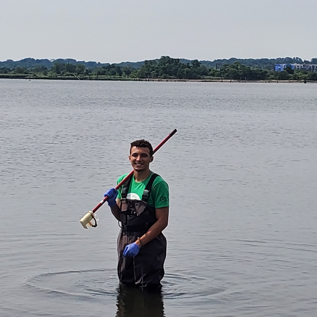
The New Jersey Watershed Watch Network’s Road Salt Impact Study is running for the 2022 winter season. Now in its third year, the NJ Road Salt Impact Study employs the help of hundreds of volunteers across the state of New Jersey to collect water quality data on chloride levels as they change throughout the season. Chloride is a constituent of road salt and tends to increase in fresh waters as salt washes off the roads into our streams and lakes.
To participate in this community science project, pick an accessible spot on a freshwater stream or lake near you. You will return to this spot six times before the end of March to measure how chloride levels change in response to road salting events. Testing takes about 10 minutes, including the time it takes to post your results to the online data portal.
Visit njwatershedwatch.org/roadsalt to learn more about the program and to request your free chloride test strips. Test packets will be mailed out in a few days.
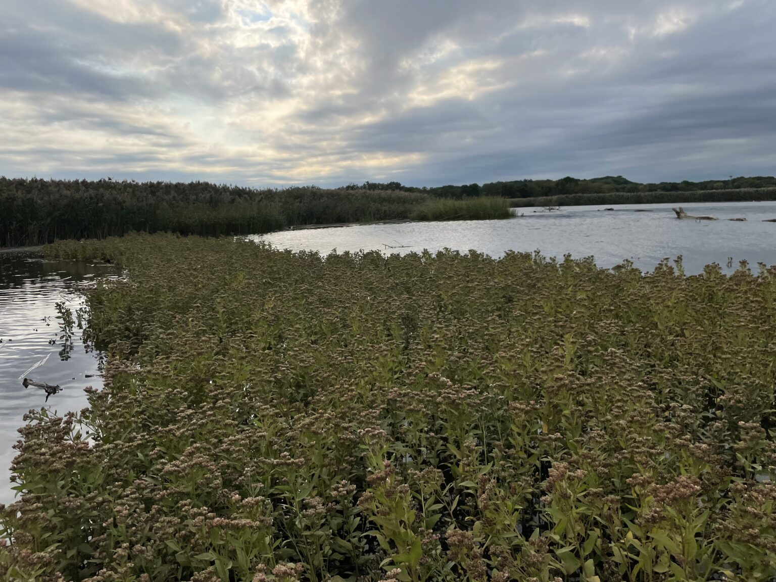
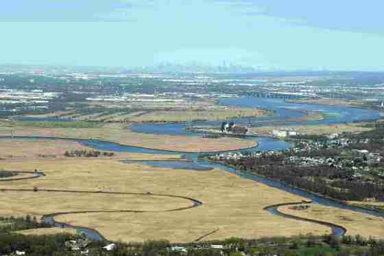
Just 50 miles southeast of New York City, tucked between two municipalities, sits a 650+ acre tidal salt marsh which spans the shorelines of the South River in densely populated, highly developed Central New Jersey. The South River is the first major tributary of the Raritan River, located 8.3 miles upstream of the Raritan River’s mouth, which drains into Raritan Bay.
The Lower Raritan River and Raritan Bay make up a large part of the core of the NY-NJ Harbor and Estuary Program. Within the Raritan Estuary, the South River wetland ecosystem is one of the largest remaining wetland complexes. While the South River salt marsh ecosystem has been spared from direct development, it has been degraded in quality, and does not provide optimal habitat for wildlife or maximum flood protection for residents. This area is subject to fairly regular tidal flooding (particularly when it occurs simultaneously with a storm) and periodic—generally more severe—flooding during more significant events such as nor’easters and tropical storms. Hurricanes Irene and Sandy caused damage in the Boroughs of Sayreville and South River too.
In 2018, Princeton Hydro and Rutgers University, along with the Lower Raritan Watershed Partnership, Middlesex County, Borough of Sayreville, Borough of South River, NY/NJ Baykeeper, Raritan Riverkeeper, and the Sustainable Raritan River Initiative, secured funding from NFWF’s National Coastal Resilience Fund for the “South River Ecosystem Restoration & Flood Resiliency Enhancement Project.”
The South River Ecosystem Restoration and Flood Resiliency Enhancement Project aims to:
Reduce socioeconomic damages to the Boroughs of South River and Sayreville caused by storm damage, flooding, and sea level rise;
Transform degraded wetlands to high-quality marsh that can reduce flooding and enhance fish & wildlife habitat; and
Engage stakeholders in activities about coastal resilience and ecological health to maximize public outreach in the Raritan River Watershed.
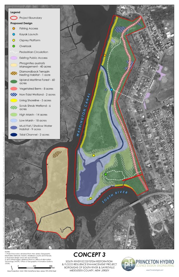
For this 165-acre tidal marsh and transitional forest “eco-park,” the project team is conducting an ecosystem restoration site assessment and design. This phase of the coastal restoration project will result in a permit-ready engineering design plan that stabilizes approximately 2.5 miles of shoreline, reduces flood risk for smaller coastal storms, and enhances breeding and foraging habitat for 10 state-listed threatened and endangered avian species.
Project Area History
This area has experienced repeated flooding, especially during large storms. For example, coastal areas of Sayreville and South River flooded after Hurricane Floyd (1999), Tropical Storm Ernesto (2006), Hurricane Irene (2011), and Hurricane Sandy (2012). Over the last century, there have been several studies and assessments completed for the South River, many of which identify this project area as a priority location for flooding improvements. The following are key reports and studies published about the project area and surrounding communities:
1930s
NJ Legislature’s 71st Congress published a report, “Basinwide Water Resource Development Report on the Raritan River Basin” which focused on navigation and flood control for the entire Raritan River Basin. It discussed recommendations for flood control and local storm drainage, setting the stage for future actions.
1970s
NJDEP Division of Water Resources published Flood Hazard Reports for the Matchaponix Brook System and Raritan River Basin, which delineated the floodplains in the South River, and its tributaries, the Manalapan Brook and Matchaponix Brook.
1980s
USACE New York District released a “Survey Report for Flood Control, Raritan River Basin,” which served as a comprehensive study of the Raritan River Basin and recommended several additional studies. Although the South River was studied, none of the proposed improvements were determined to be economically feasible at that time.
Project area was listed as one of the Nation’s Estuaries of National Significance.
1990s
USACE conducted a multi-purpose study of this area. This preliminary investigation identified Federal interest in Hurricane and Storm Damage Reduction and ecosystem restoration along the South River and concluded that a 100-year level of structural protection would be technically and economically feasible.
2000s
USACE NYD and NJDEP released a joint draft, “Integrated Feasibility Report and Environmental Impact Statement” for the South River, Raritan River Basin, which focused on “Hurricane & Storm Damage Reduction and Ecosystem Restoration.” Because it was previously determined that there were no widespread flooding problems upstream, the study area was modified to focus on the flood-prone areas within the Boroughs of Sayreville and South River, as well as Old Bridge Township.
Towards a More Resilient South River Ecosystem
Through collaboration with our project partners and following input provided from a virtual stakeholder meeting held in December 2020, Princeton Hydro developed a conceptual design for an eco-park that incorporates habitat enhancement and restoration, and protective measures to reduce impacts from flooding while maximizing public access and utility. Public access includes trails for walking and designated areas for fishing. The eco-park can also be used for additional recreation activities such as bird watching and kayaking.
Highlights of the conceptual design include the following features:
Approximately two miles of trails with overlook areas, connection to fishing access, and a kayak launch.
~3,000 linear feet of living shoreline, located along portions of the Washington Canal and the South River, to provide protection from erosion, reduce the wake and wave action, and provide habitat for aquatic and terrestrial organisms.
~60 acres of enhanced upland forest to provide contiguous habitat areas for resident and migratory fauna.
A tidal channel that will connect to the existing mud flat on the southeastern part of the site and provide tidal flushing to proposed low and high marsh habitats along its banks.
A vegetated berm with a trail atop will extend the length of the site to help mitigate flood risk.
Two nesting platforms for Osprey, a species listed as “Threatened” in NJ
Designated nesting habitat for the Diamondback Terrapin, a species listed as “Special Concern” in NJ
A short rapid at the head of an island on the South Branch demanded my immediate attention, though it was an easy and familiar passage. A few quick draws and paddle strokes allowed the canoe to negotiate the exposed rocks without a scratch. The smooth open water below the rocks, this day, appeared to be non- navigable as a herd of Holstein milk cows stretched from pasture to the far bank. The cool water must have felt so good on their udders they were reluctant to move and remained motionless, all eyes watching me silently approach.
I did my best to avoid starting a stampede and shunned the thought of owning the notoriety of being the only canoeist ever to be churned into oblivion by stampeding bovines, while paddling down a quiet river. It would certainly be an inglorious and unexpected end to a peaceful canoe trip.
The cows did give way, grudgingly, as they shifted position to allow my passage, each cow substituting for a slalom gate on a downriver run.
A a glance, the note hanging from the cow’s ear appeared to be a cartoon bubble expressing the animal’s thoughts. The cows are gone, never to return, unlike the diverse collection of wildlife populations reconstituted along our local rivers and open space.
That scenario will never happen again as the dairy farm was sold and new environmental regulations barred cattle from rivers and streams.
So it was the proliferation of dairy herds dwindled to change the perception of the character of the region from rural to land prime for development.
The absence of cows from the landscape was taken as signal that nothing remained to be saved in terms of nature or wildlife. The land without cows was sterile and devoid of life, a waste of space, only to be saved by ratables.
Unbeknownst to most, the open space and river corridor teemed with viable populations of wildlife that existed long before the cows came and remained in viable populations after the cows passed.
A common misconception about wildlife is, if you don’t see herds of animals, they don’t exist, except as anomalies. The facts are, many wildlife species, mink for example, exist in healthy populations across the state.
Animals that dominated stories of frontier days, sans mountain lions, still live among us. Tales of coyotes, black bear, otter, beaver, turkey, whitetail deer and eagles belong to wild country, pristine wilderness rarely visited by humans. Even the sound of migrating wild geese, flying a mile high in a V formation, still make the heart beat faster. The geese were travelers from the far north on a winged journey, whose eyes had seen wild places we could only dream about.
The symbol of our country, the bald eagle, until recently, existed only as marketing brands, has now established territory along our rivers, one nest producing fifteen fledglings over seven years. Eagles of all ages are now a common sight.
Trees gnawed by errant beaver looking for a permanent home line the rivers. Transients pass through each winter, occasionally homesteading for a few years. Beaver were the main attraction for early settlers and provided impetus to explore and settle the early wilderness. Again, a local animal whose lineage is associated with mountain men, wilderness and American history, remain and thrive despite the absence of cows.
As I paddled down the south branch, an oversized raptor perched on a dead tree branch extending over the river. I could not identify the species and wanted to get some images. I set the boat to drift on a course that would pass directly under the bird. To my surprise it tolerated my presence as I took my limit of images. Still thinking it was some variety of hawk, I continued on my journey. Only when editing the images, I realized I was within intimate distance of a juvenile bald eagle! I had no idea eagles even existed locally; the only one I ever saw was fifty years ago on the upper Delaware River. Consider the misconception created when the most common image of an eagle, as seen exclusively on branding, is that of an adult with a white head and tail. It is easy to ignore or mistake juvenile birds as it takes about four and a half years for the plumage to change to pure white.
The thought then occurred, beside eagles, what other unexpected wild life or endangered and threatened birds and animals existed in our midst? Rivers serve as ancient migration routes for birds and animals, the pathways imprinted in their DNA. So the opportunity exists to observe unusual species during times of migration and the possibility some may decide to take the exit ramp and remain.
Our natural treasures are hidden in plain view, their legacy continues if we recognize their existence and the importance of protecting the land along our rivers and open space.
You may not see him but rest assured he sees you! The howl of coyotes in the night, strikes a primitive cord in our DNA as we share the emotion felt by our paleo ancestors, huddled around a fire, bridging the unknown with magic and mythology.
Author Joe Mish has been running wild in New Jersey since childhood when he found ways to escape his mother’s watchful eyes. He continues to trek the swamps, rivers and thickets seeking to share, with the residents and visitors, all of the state’s natural beauty hidden within full view. To read more of his writing and view more of his gorgeous photographs visit Winter Bear Rising, his wordpress blog. Joe’s series “Nature on the Raritan, Hidden in Plain View” runs monthly as part of the LRWP “Voices of the Watershed” series. Writing and photos used with permission from the author. Contact jjmish57@msn.com.
This maroon shale cliff forming the river’s bend, serves as a memory retrieval bank for times gone by. I was canoeing with my late friend Jimmy, who caught and released a feisty smallmouth bass just upstream of that shale prominence. Memory storage may be why the shore of a river is referred to as a ‘bank’.
Over the course of time everything we experience is stored as a memory. Having limited capacity for recall, it is the most impactful memories that linger. By no means are memories ever lost, they are stored in pristine condition in unconscious archives. The key to recovery can be a scent, sight or a sound. Prompted by clues hidden in unrelated conversations, a single phrase or word can bring an experience back into sharp focus. Old, faded photographs of no particular beauty or composition can instantly bring the past into laser focus as the prompts to our memories are as individual as fingerprints.
So it is that each time I paddle the river, it becomes a physical journey through the accumulated memories collected over hundreds of miles, paddled on the same stretch of river. Each trip is like opening the old family album to add new photographs and seeing the older images as the pages are turned. It is as if a gravitational pull compels you to linger a bit longer in the realm of old memories.
There is hardly a location on the river that does not hold a memory for me. Digital images and photographs, abound, however, it is being present on the river that provides access to memories not captured by the camera or pushed aside by the endless flow of freshly minted memories.
Every time I pass the drainage above the mouth of Pleasant Run, my mind immediately plays the video of the snowy winter day I pulled out of the current into the safe harbor of a drainage stream to warm my hands under my arms. The heavy snow quickly covered me and my boat as I leaned forward, folded arms resting on my thighs. I felt safe and comfortable as the canoe was stabilized in the heavy slush and well within the six-foot-wide drainage stream away from the main current. The snow was almost a foot deep along the high bank and to my surprise a dark brown mink was porpoising through the deep snow toward the drainage and my canoe. The mink came within arm’s reach before it realized the convenient bridge and large lump of snow was an existential threat.
One summer day I had my young daughter in the bow of my canoe, as we approached the tower line near home, a large fish jumped clear of the water, hit the gallon jug of juice she was holding, bounced off the opposite gunnel and fell back into the river. Her expression was priceless, as was mine, to witness a scene that could only happen in a cartoon. Can’t pass under that tower line without reliving that moment! Though many years have passed, the clarity and even the emotion of that comedy is still retained in the tower line archives.
On an initiation canoe trip with my four-year-old grandson, I paddled close to a high shale cliff, as in my experience cliffs were a major attraction to young boys. Sure enough, Caleb was impressed and asked how to get to the top. Before I could answer I noticed a large animal on the narrow shelf at water’s edge below the cliff. We closed in on a supersized beaver munching some delicate vines growing on the cliff face. The beaver slowly moved into deeper water but not before swimming on the surface a few yards in front of the canoe. You will not be able to see it, but when I pass that cliff, it reveals a crystal-clear video of that priceless moment. Of course, the next day Caleb never mentioned the beaver to mom but was totally impressed by Grampy carrying the canoe over his head.
One early spring day after ice-out, the river was running high, and the only ice that remained was found in deep cuts into the bank where trees were washed away. As I rounded a sharp bend in the river, I kept about three feet off the left bank to avoid the main current. Immediately on my left was a large ice-covered cove about twelve feet into the high vertical bank. I could not believe what I saw! Standing in sharp contrast to the empty expanse of graying ice, was an otter! As it ran toward me, I realized its only escape route was into the water next to my canoe. At less than two feet away I watched the otter dive into the fast-moving muddy water in the narrow space between my boat and the ice shelf. I thought I was hallucinating, perhaps hypothermic. I never saw an otter on the river before or since. Consider, this bend in the river projects the memory of my close encounter with an otter, exclusively for me. It is my personal archive, available to no one else.
Memories are where you first met them, they are safe from prying eyes and remain where you last left them. The storage capacity is infinite and the keys to unlock them are everywhere.
Author Joe Mish has been running wild in New Jersey since childhood when he found ways to escape his mother’s watchful eyes. He continues to trek the swamps, rivers and thickets seeking to share, with the residents and visitors, all of the state’s natural beauty hidden within full view. To read more of his writing and view more of his gorgeous photographs visit Winter Bear Rising, his wordpress blog. Joe’s series “Nature on the Raritan, Hidden in Plain View” runs monthly as part of the LRWP “Voices of the Watershed” series. Writing and photos used with permission from the author. Contact jjmish57@msn.com.
We are pleased to announce that the LRWP’s MS4 Municipal Stormwater Management Assistance Program has launched via our first municipal partnership with Highland Park!
This new fee-based program is designed to help municipalities in the Lower Raritan Watershed meet their federally mandated stormwater management education & outreach requirements under the Clean Water Act.
THE NEED:
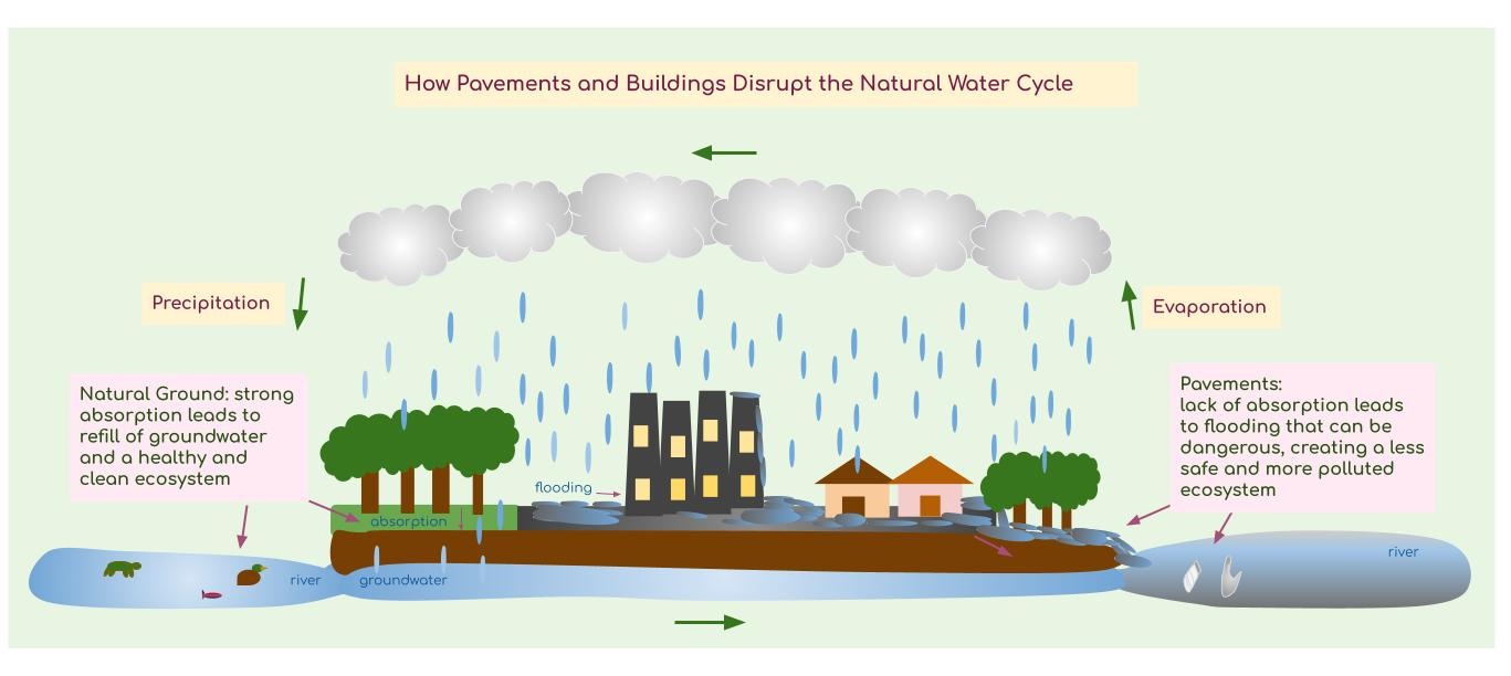
Hurricane Ida told us that we must interrogate our current stormwater management systems, study the effects of stormwater runoff in our local townships, and implement through advocacy, policy, and community discussions, a more sustainable way to prevent stormwater from contributing to flooding or degrading the water quality in our streams and rivers. The trick? We must allow more rain to soak directly into the ground where it falls. There are so many ways to do this: by developing ecologically sensitive master plans for our municipalities, by ensuring maximum protections for our waterways and floodplains, by reducing impervious cover (hard surfaces) in all parts of our communities, by restoring degraded lands to allow for improved porosity, and by making dozens of “environmentally smart” personal choices every day. The LRWP is here to help! Please contact us to learn more!
DID YOU KNOW?
Municipalities can tap up to 25% of their New Jersey Clean Communities allocated funds to support required stormwater education.
THE LRWP’s MS4 MUNICIPAL ASSISTANCE PROGRAM:
Through the LRWP’s Municipal Stormwater Management Assistance Program, we engage multiple forms of community outreach to increase everyday visibility of how our waterways and streetways are connected.
Here are a few examples of the direct assistance the LRWP can provide:
General Public Outreach (development of stormwater webpages, newsletters, materials sharing in kiosks and municipal spaces)
Target Audience Outreach (demonstrations at municipal festivals and events, educational program development for DPW and other municipal staff, #lookfortheriver community training)
School/Youth Education & Activities (direct engagement with youth via STEAM-based environmental education and programming using the LRWP’s Next Generation Science Standards Project WADES curriculum)
Watershed Regional Cooperation (stormwater management workshops for continuing education credits, programming on stormwater utilities, programming on integrated urban watershed management)
Community Involvement Activities (community clean-ups, stormwater management plan development, rain garden builds, impervious cover removal, and more!)
An MS4 (Municipal Separate Storm Sewer System) is called a separate system because it does not combine with the sanitary sewer system and it is designed to gather water on the streets via storm drains and pipes and release it, without treatment, into local streams and rivers. Poor stormwater management in our communities not only leads to compromised water quality, but also flooding.
HERE’s HOW WE DO IT!
Partnership initiatives with Highland Park for Year One include developing a new stormwater webpage, stormwater newsletter, hosting community clean-ups, conducting water quality monitoring of a local stream, and hosting a “Municipal Actions to Address Stormwater and Flooding” workshop to look at stormwater management from a regional, or watershed, perspective.
Highland Park Stormwater Website
Highland Park’s new website provides educational resources, graphics, mapping, and analysis for residents to learn about Highland Park’s waterflow and stormwater management system. What’s on our streets enters our local streams that enter the Raritan River eventually connecting to the Atlantic Ocean. Did you know that almost half of the ground in the Boro of Highland Park is covered by buildings and pavements?
Highland Park Stormwater Newsletter
Stormwater management materials will also reach the mailboxes of Highland Park residents via a new stormwater newsletter! Residents can read the story of how the ecosystem and water cycle of the Borough has changed since we’ve built more pavements and constructions. Check out our “Stormwater Word of the Month” section!
Special thanks to LRWP StreamKeeper Susan Edmunds for her amazing photography and writing. We encourage you to check out more of her poetic and creative science communication work via her storymap piece Mill Brook: Portrait of an Urban Stream.
Workshop on Municipal Actions to Address Stormwater and Flooding October 7th 3 PM The LRWP is hosting a free workshop to discuss how we can create policies and municipal actions to minimize flooding and improve water quality. This workshop will be informative, engaging, and a great way for community members, educators, local officials, employees, or anyone else to get involved in community stormwater management discussions. Our Keynote Speaker is Rosana DaSilva, Water Quality manager with the New Jersey Harbor & Estuary Program. See you there!
Highland Park Stream Clean Up September 26th
It was a beautiful Sunday morning where LRWP volunteers, Highland Park residents, and Rutgers students gathered on River Road with gloves and garbage bags, ready for a couple hours of hard work. Hurricane Ida had washed trash back onto the floodplains and local trails. Slowly our bags got heavier and heavier until we made our final trip down through Johnson Park to the dumpsters. LRWP intern Jason Acevedo described the experience of looking for trash as investigating a mystery, searching for clues to tell a story, “looking at a crime scene”. We found glass pieces, water bottles, wrappers, plastic bags, and even a pair of pants and a tire. As we encountered them, we wondered about all the possible ways they had gotten there, concluding that there are so many. They could have been left there by people passing by or could have been swept in by the river having entered it from literally anywhere. We are excited to co-host our next clean up which is a multi-site clean up of the Green Brook on October 23rd from 10 AM to 1 pm!
An elephant is like a tree, No! an elephant is like a snake, No! an elephant is like a wall. So claimed the three of the six blind men from Indostan, when they were asked to describe an elephant. In this case their blindness is representative of a loss of perspective and in that way, reflects on our nature to define the world into segmented parcels.
Being gravity bound to the earth provides a limited view and so, it makes sense to parse the world via man made contractions. For instance, take a local county road, built to traverse through several counties, towns and cities. To ensure continuity it was given a numeric designation. County route 514 is an example. However, as it crosses geopolitical borders it gets christened with a local name. Amwell Road, Hamilton Boulevard, Woodbridge Avenue and Main Street, etcetera, collectively are the same road, county route 514.
It is human nature to tease out pieces of the whole to better grasp an extensive subject. Our education system has honed specialization of studies to create unique disciplines and professions, each treated as unrelated kin.
Over time we have lost perspective of the whole and dismantled the larger puzzle into its component pieces, forgetting that all disciples are related and taken together, are additive and complementary. Formal education has handed each disciple of its hallowed halls a critical piece of the puzzle. Much like a treasure hunt, where a map is torn into pieces and handed out to individuals to ensure all participants must bring their scraps of paper together to find the hidden gold.
When we look at rivers, our earth bound position shapes our view. We see the north branch of a river apart from the south branch, each stream that feeds into a larger waterway gets a name. As a watercourse passes a political jurisdiction, that flow of water may, in some unusual cases, get a name change, not unlike our numbered county routes. Trace a stream back to its source and discover it doesn’t get a name on a map until it crosses a roadway.
I had the opportunity at the invitation of No Water No Life founder Alison Jones to accompany her and Lower Raritan Watershed Partnership president, Dr Heather Fenyk on a complimentary flight provided by LightHawk to photograph the entire Raritan watershed from its two main sources all the way to Raritan Bay and Sandy Hook.
The transition from a ground dweller to eagle was as breathtaking as it was revealing. Instead of only seeing puzzle pieces, the entire picture of the watershed miraculously appeared. Each segment lost its defined edges as the resolution increased; as if going from a pixilated image to a crystal clear picture.
Though intimately familiar with each section of the river, I was lost when asked where we were at any given moment. I tried to rely on referencing the last known position but the speed at which we travelled, and the new cloud high perspective was surprisingly disorienting. It takes about an hour and ten minutes to drive to Sandy Hook from the point of the confluence of the Raritan and its main branches, it took only a few minutes to fly there. That alteration of time and distance also serves to overcome the linear relationship of diminishing interest over increasing distance, a lingering, innate human survival mechanism focused on serving the moment to save the day.
The value of gaining a new perspective, where the threads reveal the weave of the cloth, provided an avenue for a holistic approach to temper human impact on the watershed as an entity. A change to any geo-politically defined segment must now be considered as systemic rather than an isolated local impact. Impervious surfaces increase upstream from housing developments and parking lots to flush more water into the river and exacerbate extreme weather flooding. Crops planted in the flood plain right to the edge of the river, cause erosion and silt build up to force flood waters further from the main river course.
A good lesson to remember is the literary relationship of the word river to rivalry. The word for people drinking from the same stream or river was rival in French and rivalis in Latin. When a downstream village’s drinking water was contaminated by the village upstream, it created a rivalry. Even in early times, the wisdom of what flows downstream was well ingrained in riverine communities, a lesson somewhat lost today.
In lieu of boarding a plane, fire up your imagination. Imagination is a magic carpet that transcends available opportunity, bad weather and poor visibility to deliver needed perspective. Imagine if you can the water in the entire Raritan River watershed replaced with blue injection molded latex as a giant hand reaches down and grabs the main trunk of the Raritan River, pulls it from the earth, and holds it aloft as if it were a giant oak tree, its crown represented by the ocean. The fine mass of hairy threads leading into primary roots and finally forming a main trunk. See the river as a tree, its form and function more similar than different.
A River’s watershed or tree, both a conduit for flowing water, perhaps an alternative way to grasp the concept of the extent of a watershed. Overlay this image on a land map to visualize a watershed, whose dimensions are typically presented in incomprehensible numeric values. Original artwork by Richard Reo
Loss of perspective is a demon that transcends all issues and stunts efficient problem solving, leads to false conclusions, lost time, and energy.
Perspective may be gained in several creative ways, though it takes imagination and an open mind to intellectually take flight to see the whole picture. Once we realize our world is one entity and the smallest change has a cascading effect far downstream beyond where we figured the ripples terminated, we are better prepared to approach business, technology, relationships, education and nature while promoting the sage advice of ‘first do no harm”.
New York City as seen from the lower Raritan river begs a hand to reach out and touch it, as opposed to driving for hours on congested toll roads and across bridges. When distance and time reduced, it brings a new perspective and increased interest. Flight compliment of LightHawk and No Water, No Life.
Author Joe Mish has been running wild in New Jersey since childhood when he found ways to escape his mother’s watchful eyes. He continues to trek the swamps, rivers and thickets seeking to share, with the residents and visitors, all of the state’s natural beauty hidden within full view. To read more of his writing and view more of his gorgeous photographs visit Winter Bear Rising, his wordpress blog. Joe’s series “Nature on the Raritan, Hidden in Plain View” runs monthly as part of the LRWP “Voices of the Watershed” series. Writing and photos used with permission from the author. Contact jjmish57@msn.com.