We know that waters throughout the Raritan Basin contain unsafe levels of nutrients, fecal coliform and other pollutants – much of this type of polluting is directly related to “non-point source” pollution, most often stormwater runoff, which can be linked to land development and an excess of hard or “impervious” surfaces like roadways, asphalt parking lots, and buildings. Portions of our Lower Raritan Watershed also fail to meet federal Clean Water Act standards for phosphorous, pH, arsenic, chromium, mercury, copper, lead, temperature, dissolved oxygen, total dissolved solids and other pollutants. Some of this is due to historic “point source” dumping and legacy contaminants, and some of this is due to ongoing permitted point source polluting.
What is Permitted Point Source Polluting and who are New Jersey’s Permitted Polluters?
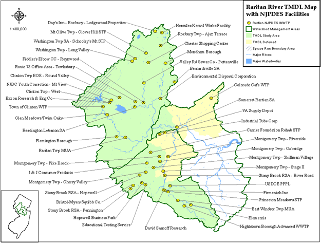
The New Jersey Pollution Discharge Elimination System (NJPDES) Program is designed to protect New Jersey’s ground and surface water quality by regulating treatment and discharge of polluted wastewater and stormwater from various types of facilities and activities. To accomplish this, the New Jersey Department of Environmental Protection (NJDEP) issues permits to polluting facilities limiting the mass and/or concentration of pollutants which may be discharged into ground water, streams, rivers, and the ocean. The types of regulated facilities can range from small users to large industrial and municipal wastewater dischargers. A complete list of the NJPDES permitted polluters for 2020 can be found here:
How can we protect our waterways from point source pollution?
The NJDEP is required by the Clean Water Act to create and implement a plan to remove pollution from impaired water bodies. They do this by preparing a TMDL, or Total Maximum Daily Load determination for a water body. A TMDL is a scientific determination of the maximum amount of a given pollutant that a surface water body can absorb and still protect human health and aquatic life.
Unfortunately for the Lower Raritan, we do not have a TMDL. A TMDL to address pollution in the Raritan Basin was begun in 2016, but for our area – the Lower Raritan Watershed – it is incomplete. The white area in the map below shows swaths of land, and the NJPDES Facilities (permitted polluters) on that land that are not covered by a TMDL. Now this does not mean that polluters can pollute at will, but what it does mean is that we have less of a real sense for what pollutants are in our waters, or for what harm the mix of pollutants might cause.
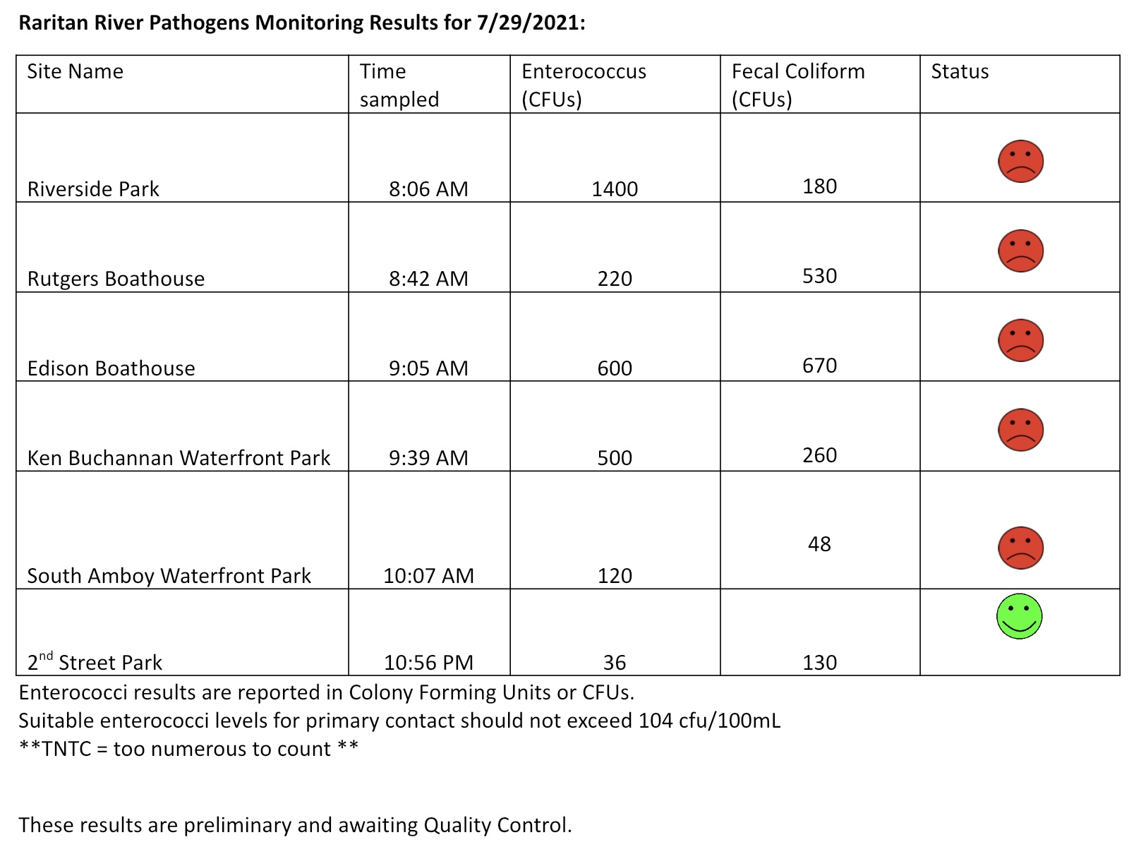
The Lower Raritan Watershed Partnership and Rutgers Cooperative Extension of Middlesex County run a volunteer pathogens monitoring program from May to September every Summer. On Thursdays we collect water quality samples at 6 non-bathing public access beaches along the Raritan River, and report out the results on Friday afternoons. Our results for 7.29.2021 are not so good. And the water samples were taken before over an inch of rain fell on the Lower Raritan, which almost always kicks up pathogens and bacteria. If you choose to recreate on the water this weekend, stay safe, and be sure to wash your hands! See here for more information on our pathogens monitoring program.
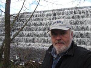
From its headwaters in the Devil’s Brook Swamp at Monmouth Junction, to its outlet on the Raritan, Lawrence Brook once powered six mills from Deans to New Brunswick. Over the next few months local historian Richard Walling will share his research (including photos and maps) into the history of the Lawrence Brook Mills sites and their relationship to our Raritan River and Lower Raritan Watershed.
Richard is pictured here at the Farrington Lake step-dam, the site of a mill dating to the 1750s. He writes: “By the way, if the Brits had continued their 1778 withdrawal from Philly towards New Brunswick, what developed as the Battle of Monmouth could have taken place along the Lawrence Brook.“
This is the first in a series about mill sites along the Lawrence Brook.
Let us begin at the beginning: Geologically speaking, the Lawrence Brook generally separates two types of land forms in central NJ: the Piedmont & the Inner Coastal Plain. Brunswick shale is to the north of it, and loam to the south of it. The famed Middlesex County clay district extends westerly along the southern bank of the stream, at least as far west as Farrington Lake. Many of us remember digging gray clay from the shoreline near the broken dam in present-day Bicentennial Park (East Brunswick).
The Lenape called the stream, piskëpekw [-w is a whispered voiceless w], meaning “dark water”. Whether this alluded to the water’s color, to the shadowed waterway caused by steep banks, or even possibly from it’s headwaters at Devil’s Brook Swamp (did the Lenape call Devil’s Brook by the same connotation in their own language?). The land form of a neck, where Rutgers Village is located, was called ramawùnk (Ramawon in English), meaning “under the hill” or “under the bank”. Translations are provided by Lenape linguist, Ray Whritenour.
Native American artifacts are found all along the stream’s course and a path still runs along its eastern portion in the vicinity of Rte. 18 near the NJ Turnpike (Westons Mills). When a parking lot was being constructed on the Cook College campus, a cache of projectile points was found. The high ground at places like von Thun’s farm in South Brunswick, and Rutgers Gardens in New Brunswick once hosted villages. I know many folks who picked up artifacts in East Brunswick along Farrington Lake.
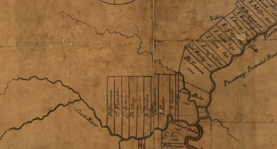
The earliest land transfer was from Native leaders to Thomas Lawrence, The Baker, a NY city merchant. As you can see from the circa 1685 map of the area, his holdings were affirmed by the East Jersey Board of Proprietors.
Map from 1685 showing the Lawrence Brook in relation to the Rariton (sic) River, South River, and land holdings of the time, source: https://www.loc.gov/item/97683564/
CONVEYANCE. Land called Ramawon on the south side of the Raritan River. [East Jersey].
Tract of land called Ramawon bounded by the Raritan and Pisscopeck Rivers.May 1, 1678
TO: Thomas Lawrence (Baker) (of New York; [Lawrence the Baker])
FROM: George Carteret (Sir) (Lord Proprietor); Philip Carteret (Esquire) (Governor of the Province)
PATENT. 1300 acres. South side Raritan River; a creek called PiscopeckIn 1693, the creek, now called Lawrence Creek (Brook), was granted to Peter Sonman, running from near Rocky Hill, all the way to Thomas Lawrence’s grant along the Raritan.
Oct. 20, 1693 TO: Peter Sonmans (Merchant) (of London; Proprietor; Son of Arent Sonmans, deceased, and Frances Sonmans; Brother of Johana Sonmans and Rachell Sonmans)
FROM: Proprietors of the Province of East New Jersey
CONVEYANCE. 38600 acres. Between Milston and Raritan Rivers; beginning at the Partition Line between East and West Jersey; opposite the foot of Rockie Hill; on both sides of Lawrence Creek; to the South River; Middlesex County.
June 7, 1677 Conveyance Record. NOTE: Isarick may have been the father of Wequeheela, who resided in present-day Spotswood.
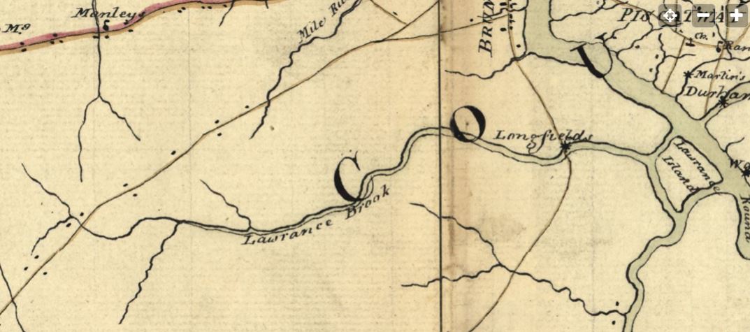
The 1781 map below, drawn by a British Army cartographer, is a general depiction of the stream, and of George’s Road (present-day Rte. 130 in part), George’s Road led from George Rescarrick’s Tavern (circa 1686) in Cranbury to New Brunswick. Below Cranbury, it led to Hightstown, Allentown, Crosswicks and points south. Longfield’s Mill is where Rte. 18 crosses the stream, a stretch known as Westons Mill.
Rich’s next installment will be on the Headwaters of the Lawrence Brook.
Since 2018 the LRWP has worked with Piscataway Township resident and Girl Scout Gabriella Robinson to increase awareness around water quality and actions individuals can take to improve the health of our local waters. Through this work Gabriella, a member of Troop 80877 and a rising senior, is completing the requirements for her Gold Award, Girl Scout’s highest honor. We are so grateful to Gabriella for her stewardship! See below for a summary of her work, in her own words, with a link to a video she developed for outreach. Thank you, Ella!
By Gabriella Robinson
Piscataway Girl Scout Gabriella Robinson
Go Green Central NJ is a water pollution prevention and awareness project!
I have been working on my project for about 2-3 years (2018 to present) and joined local cleanups, organized cleanups, and participated in discussions on environmental racism and how it connects to water pollution. I also created a video to increase the awareness of pollution of the Raritan River. I wanted people to know that every piece of garbage they pick up makes a difference in improving the water quality of the Raritan River and our community. Through these activities, I have learned more about what we can do to lower water pollution and bring awareness to others. I hope to continue helping others with my project to prevent water pollution!
Ten weeks down, ten weeks to go — we are halfway through the season!
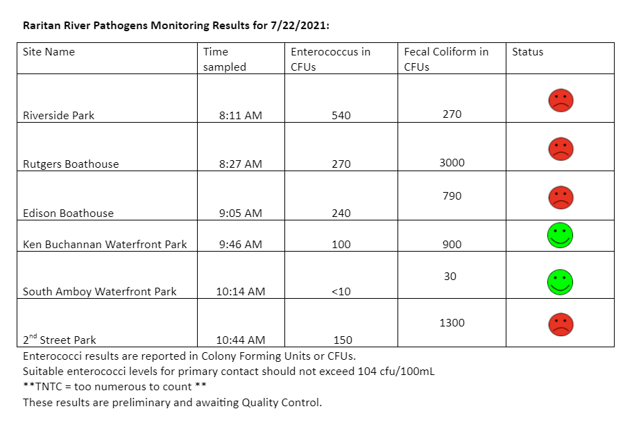
We are starting to see our pathogens / bacteria numbers climb, perhaps a factor of warmer temps and increased precipitation? We’ll know more at the end of the season when we run analyses. For now, see pathogens monitoring results for Thursday 7.22.2021 below.
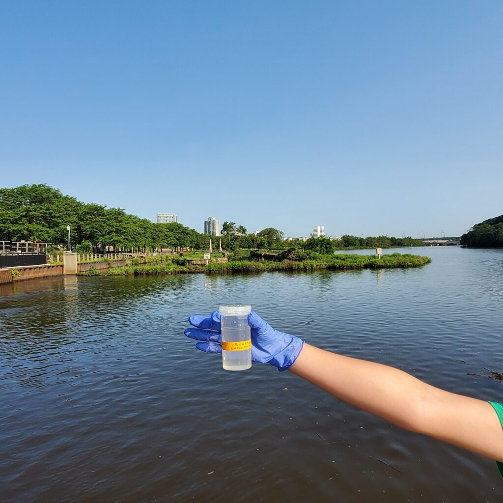
Catching samples at Rutgers Class of 1914 Boathouse, with the terminus of the Delaware & Raritan Canal and the City of New Brunswick in the background.
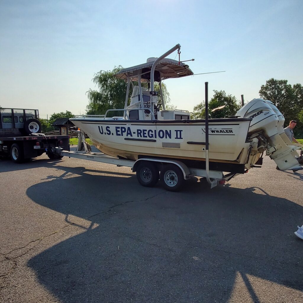
We met up with EPA Region II at our Edison site this week. For Summer 2021 microbial source tracking they catch “in-channel” samples by boat, we catch samples from land.
Los resultados de los enterococos se reportan en unidades de formación de colonias o UFC. Los niveles adecuados para el contacto primario no deben exceder las 104 ufc/100 ml. Tenga en cuenta que aunque los números parecen buenos para nuestros sitios de Edison, Sayreville, South Amboy y Perth Amboy, hemos recibido bastante lluvia desde el muestreo, lo que generalmente aumenta la carga de bacterias en nuestras aguas. Los niveles de patógenos/enterococos se utilizan como indicadores de la posible presencia de bacterias que cargan enfermedades en las aguas recreativas. Esos patógenos pueden causar un riesgo para la salud de las gente que pescan y nadan en estos cuerpos de agua. Algunos fuentes de bacterias incluyen Desbordamientos de Alcantarilla Combinados (DAC), centros de tratamiento de aguas residuales que funcionan incorrectamente, escorrentía de aguas pluviales, fugas en los sistemas sépticos, cadáveres de animales, y escorrentía de los almacenamientos de abono.
Muchas gracias a nuestros socios: Rutgers Extensión Cooperativa del Condado de Middlesex y la Comisión de Control Interestatal para la Contaminación del Agua.
As I type this the Oregon Bootleg Fire, fueled by historic drought, burns an expanse of dry forest lands approximate in size to our Lower Raritan Watershed. In Europe, relief agencies in Germany, Belgium, Switzerland, and the Netherlands work to clean-up after intense rainfall caused deadly flooding. In one case extreme drought, the other extreme precipitation. In both, a story of climate change told through an intensified hydrological cycle, the result of warming caused by greenhouse gas emissions.
While we all know that to address climate change we must reduce our carbon footprint, consume less and recycle more, improve energy efficiency, and green our commute, few of us think about how understanding and caring for our local hydrology also makes a difference. At its core, watershed stewardship involves managing the relationship between the hydrological cycle and the lands we live on. Good watershed management not only means cleaner waters and a healthier environment, but for fire and flood control it can be a life-saving strategy. This is especially critical for areas like our Lower Raritan, which tops a list of US regions with Superfund sites at risk for climate related flooding, sea level inundation, and fire.
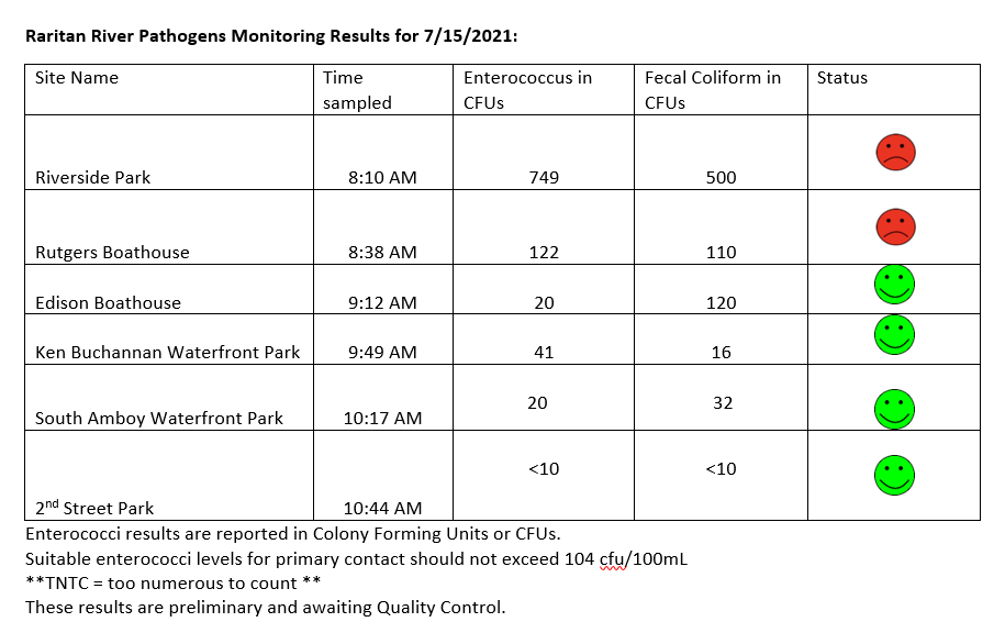
The Lower Raritan Watershed Partnership and Rutgers Cooperative Extension of Middlesex County run a volunteer pathogens monitoring program from May to September every Summer. On Thursdays we collect water quality samples at 6 non-bathing public access beaches along the Raritan River, and report out the results on Friday afternoons. Our results for 7.15.2021 look pretty good! See here for more information on our pathogens monitoring program.
Happy Weekend!
We had a great team out for pathogens monitoring, and put all hands to work catching samples, documenting habitat, and recording data. THANK YOU VOLUNTEERS!!
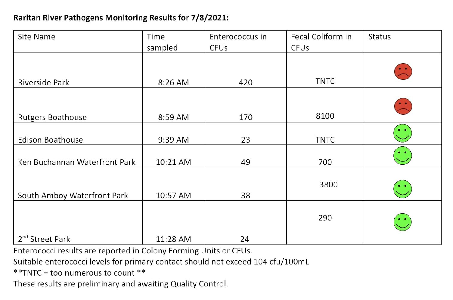
The Lower Raritan Watershed Partnership and Rutgers Cooperative Extension of Middlesex County run a pathogens monitoring season running from May to September every Summer. Every Thursday we collect water quality samples at 6 non-bathing public access beaches along the Raritan River, and we report out the results on Friday afternoons. See here for more information on our pathogens monitoring program. Below are our monitoring results from July 8, 2021. Please remember that we received significant rainfall yesterday and today associated with Tropical Storm Elsa, the rain coming after our monitoring activity. The numbers look much better than they might have had we sampled this morning. As always, many thanks to the Interstate Environmental Commission fro lab analysis and support, and special thanks to our wonderful volunteers.
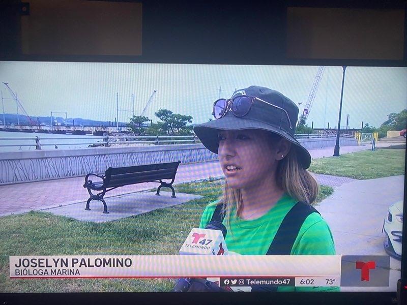
Yesterday our Community Outreach Coordinator Jocelyn Palomino was interviewed by Telemundo! Jocelyn spoke with the Telemundo reporters about the impact of precipitation and storms like Tropical Storm Elsa on pathogens levels and water quality in locations with combined sewer outfalls, like our monitoring site near 2nd Street Park in Perth Amboy (see photo below). Part of Jocelyn’s outreach for Summer 2021 involves connecting with Spanish-language communities to engage in volunteer water quality monitoring activities and bringing attention to Raritan River (and Bay) recreational opportunities.
PLEASE JOIN US JULY 10 for CITY OF WATER DAY!!! Speaking of Raritan River recreational activities, tomorrow, Saturday July 9, 2021 Jocelyn will be at 2nd Street Park, joining Rutgers Cooperative Extension Water Resources, the City of Perth Amboy, and Perth Amboy SWIM for City of Water Day! Celebrate City of Water Day by participating in a variety of activities targeted towards Perth Amboy residents from ages 16 and up! Participants will be educated on the basic structure of a combined sewer system and a brief description of Perth Amboy’s system will be presented as well. Kayaking and water sampling (fecal coliforms) will also be available with an explaination to be given to attendees of why the water may be cleaner or dirtier on that given day due to the outfall at the end of Second Street. Kayaks will be available to use for a designated amount of time and water sampling participants will use two kits to collect 20 samples from either the shoreline or while they are kayaking. The participants who collect the samples will be emailed a description of the results when they are determined.
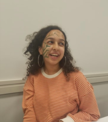
By LRWP #lookfortheriver Outreach Coordinator Anjali Madgula
Timescales
When we talk about human caused climate change, often we are talking about time. How much time does it take for a global ecosystem to undergo significant change? How much time does it take for pollution to affect a local community, a whole country, and then a global ecosystem? How much time do our plastics spend in our hands, in a landfill, in an ocean, in the stomach of a sea creature, and as a toxic substance spreading into our communities and bodies? And how much time do we have, to implement change and achieve just and sustainable living conditions for all?
Often, climate issues have to be approached in unique and creative ways because of their slow moving yet massive impacts. In his book, Slow Violence and the Environmentalism of the Poor, Rob Nixon outlines the concept of slow violence, which he defines as the “delayed destruction” that is character of climate disasters that span over decades and centuries, occurring through everyday toxic buildup and greenhouse gas emissions. Unlike violence that is immediate, visible, and sudden, the slow violence of environmental degradation is much more difficult to draw attention to in everyday media, despite being seriously capable of damage. Nixon writes, “How can we turn the long emergencies of slow violence into stories dramatic enough to rouse public sentiment and warrant political intervention, these emergencies whose repercussions have given rise to some of the most critical challenges of our time?” (Slow Violence, 3).
Earth Overshoot Day
People across disciplines are using narratives, statistics, and actions to make visible the long term scale of the climate crisis alongside the need for carbon heavy countries to decarbonize and transform their infrastructure in the immediate present. In 2006, an organization called Global Footprint Network created the concept of Earth Overshoot Day. Earth Overshoot annually calculates the calendar date for when the amount of our resource consumption for that year exceeds the amount of the Earth’s biocapacity (the amount of resources generated by Earth that year). The GFN’s work showcases the climate story across the human and nonhuman in the unique frame of just one year’s biocapacity and consumption.
In the past few decades, Earth Overshoot Day has moved steadily from the middle of October closer to the end of July, meaning not only that we are consistently consuming way more than the Earth generates per year but also that we are consuming more every year. Only in 2020, did Earth Overshoot Day get pushed to August 22nd due to a decrease in our annual ecological footprint from the first half of the COVID pandemic. However, in 2021, the calculations remain on par with the previous trend: Earth Overshoot Day will be on July 29, 2021.
The GFN also calculates an individual country’s Overshoot Day, which tells us when Earth Overshoot Day would fall if the whole world consumed like that country does. If everyone consumed in the manner that the United States of America does, Earth Overshoot Day would have been on March 14, 2021, just barely three months into the year.
In examining these statistics, it is important to reflect on where the onus for climate action lies and how carbon heavy countries harm countries with lower consumption rates on multiple levels, through overburdening the global climate but also by establishing industries and toxic activities in marginalized communities across the world.
Reflection through Local Restoration
Reflecting on the implications of Earth Overshoot Day during this extremely hot summer, invites me to ground myself in the work and movement building of our local communities in New Jersey and the Lower Raritan Watershed. While a global framing is essential, we can document changes in our own ecosystems and build community around stewardship and advocacy to make restoration and resilience possible. We can engage in discussions about resources, energy, and carbon emissions, by drawing attention to the specific issues and experiences of our community here. In order to have the greatest impact, it is important to have as many community members involved!
During the month of July which is marked by the 2021 Earth Overshoot Day on July 29, we can get involved with the new and continued programming of our watershed. The LRWP’s #lookfortheriver campaign has a new instagram page (@lookfortheriver) where you can be up to date with the citizen science work of the FRAMES sculpture in Boyd Park and other #lookfortheriver activities. The LRWP is also launching a stormwater management assistance program to help townships meet their federally mandated stormwater management education requirements.
These programs, amongst others, create spaces for us to navigate the global ecological crisis by protecting the ecosystems we have made a home within.
Citations
Nixon, Rob. Slow VIolence and the Environmentalism of the Poor, 2013. “Earth Overshoot Day” , overshootday.org, July 2021.
Hello! My name is Anjali and I am a recent graduate of Rutgers University with a major in English Literature and minors in Creative Writing and Environmental Policy. I am excited to be working with the LRWP on community outreach for the #lookfortheriver project and the pilot MS4 municipal stormwater management assistance program as it rolls out in Highland Park. The MS4 stormwater assistance program is designed to help townships in meeting their federally mandated stormwater management outreach requirements. The program seeks to communicate with residents by solidifying a network for direct and accessible stormwater management education that highlights the serious impacts of stormwater runoff on our communities. More on this soon!
My background includes hub coordinator for Sunrise Movement Rutgers, through which I’ve led training, created social media campaigns, and planned direct actions with local coalitions for environmental justice. I’ve also worked on outreach for climate strikes, divestment campaigns, and faculty union advocacy during my time as a Rutgers student and a member of the Rutgers Climate Task Force Student Advisory Panel.
Through my academic work with environmental humanities, I am passionate about reading and writing narratives that don’t treat the environment as a separate story but as one that is completely entangled in our own culture, desires, and everyday lives. I was the recipient of the James Suydam Prize in English and the Evelyn Hamilton Award in Non-Fiction for the Spring 2021 Rutgers English Department Awards. I’ve also written about avenues for movement building as a staff writer for both UnpublishedZine and The Rutgers Green Print. To check out my publications, click here! https://linktr.ee/anjalim
In my free time, I enjoy dancing, watching animated television shows, and making cottage cheese chocolate chip pancakes with my friends. I love meeting new people so feel free to reach out to me at anjalimadgula@gmail.com.