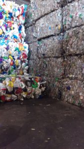
Our friends at Bayshore Recycling are still recovering from the December 16 six-alarm fire that devastated parts of their plant. While their Recycling Class A paper, plastics and metal facility was not affected, they have asked that we reschedule our tour for later in the year.
We will include notice of reschedule in our newsletter.
This is your chance to follow the recycling journey with your own eyes, observing how what’s left at the end of your driveway is sorted, prepped and packaged to get it ready for the next phase of reuse. Gary Sondermeyer, VP of Operations at Bayshore Recycling, will explain it all with this behind-the-scenes tour.
This is a great opportunity to learn more about the importance of recycling, the convenience and drawbacks of single-stream recycling, and how it’s all done. You’ll also leave with some first-hand do’s and don’ts.
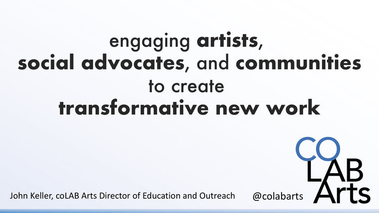
On December 13, 2019 LRWP collaborator and coLAB Arts co-producer and Director of Education John Keller delivered the opening plenary to the 2019 Jersey Water Works annual statewide summit at the Hyatt Regency Hotel in New Brunswick, NJ. John talked about the intersection of art, and our work in the watershed. He gave lots of examples of our collaborative effort these past 5 years. With thanks to John for allowing the LRWP to share his words.
Good Morning Everyone,
Uh, oh. I have to be that first person who annoyingly chastises you for being lack luster in your morning greeting. Think of it this way. It is Friday! You are coming to have a great time at this symposium, learn lots of stuff, have some good conversations, have la meal and still be out by 2:30! And as long as you don’t have a boss who is a party pooper it’s highly unlikely that any of us are going to go back to the office for just a few measly afternoon hours so that means found time! Maybe you’ll stop by your favorite independent coffee shop and have a nice afternoon latte in your favorite reusable cup. Then go over to the local day-spa maybe get a message or a nice facial (as long as it doesn’t have any microplastics in it), then meet up with some friends or family for a movie afterwards, but you will bring your own refillable BPA free water bottle because you are a little dehydrated from the latte, message, and facial and don’t want to pay $12 for a bottle of water at the theater. Then you will get out of the movie and think to yourself… wow that was a pretty good day.
So, let’s start this over.
Good morning everyone!
My name is John Keller and I have titled this presentation. 5 years of art in 9 minutes.
I am the director of education and outreach for a non-profit arts organization called coLAB Arts. You can find us on all the social media stuff as @colabarts.
I am here to tell you a story. The story is how an arts organization found itself motivated and inspired to facilitate conversations around our watersheds, and our relationship to water.
First, a little background. What is coLAB Arts and how does our mission drive us to collaborate with non-arts based social advocacy organizations, government institutions, and community groups?
Our mission is quite simply an equation. We engaged artists, advocates, and communities to created transformative new art-work. For us transformation must be three things. It must be sustainable, positive, and community focused. We work in areas as diverse as juvenile justice reform, transgender rights, domestic violence prevention, and dignity for our immigrant neighbors.
But this one is about water. So here we go.
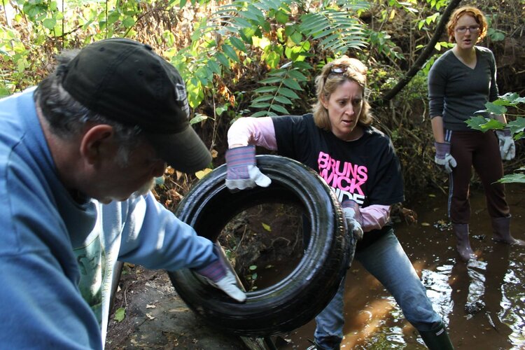
In 2015, myself and two coLAB Arts’ board members attended a watershed education workshop with the then recently formed Lower Raritan Watershed Partnership (LRWP). After the workshop we adopted a local stream and found what so many find in our urban areas: a stream in need of some love. We asked ourselves what we ask ourselves whenever engaging with a new advocacy concern:
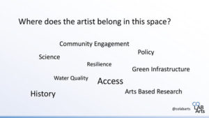
How does the artist engage in this space?
What are the core issues that the advocacy partners are wrestling with? What are the historic contexts? What are the socio-political barriers to equity, diversity, inclusion, Justice and Access that the arts might help dismantle? Who are the communities not yet at the table? What are the questions not being asked? What are the ways artists can influence and augment research? – quantitative and qualitative data gathering. What are the complex ideas that artists can infuse into the conversation to make advocacy and even infrastructure better?
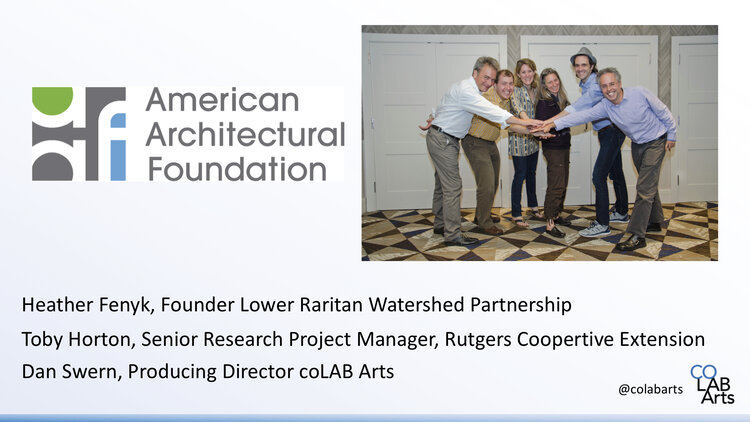
When LRWP heard these questions. And challenged us with some of their own for us to ponder. It was kismet. We began working together. Two organizations, arts and science. We formed a working group of artists, landscape architects, community organizers, and civic scientists, to wrestle with arts-based interventions to our natural and built environments. Early recognition from the American Architectural Foundation and their Sustainable Cities Design Academy gave us the opportunity generate bold ideas around on how the arts can drive sustainable changes to complex structural challenges.
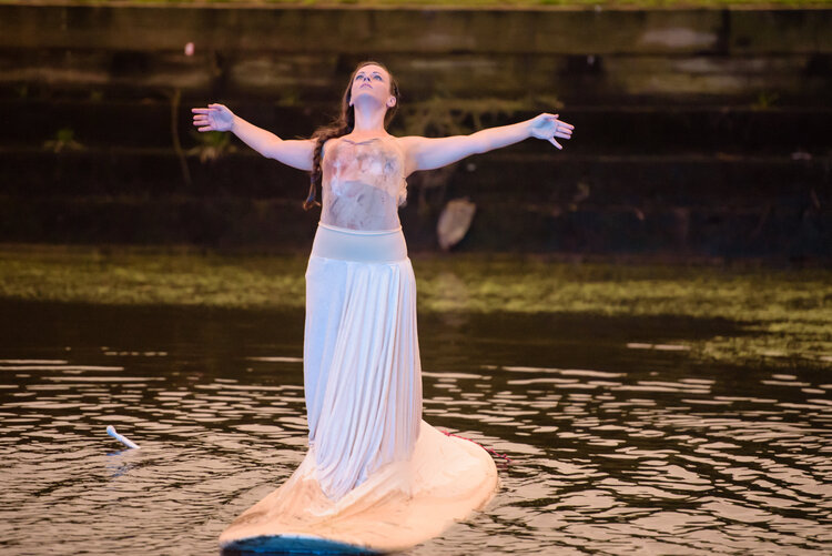
We centered on a seemingly simple idea to drive the story of the work. It is the idea that the river is both a physical entity in our landscape, but it is also a powerful metaphor in our daily lives. It is all around us. It does not just exist in the physical limitations of the banks of a body of water, but it exists in our storm water systems, in the run-off from our homes, in our sprinklers, our faucets, in our dreams for quality of life, in our stories of migration, and our desperation in times of crisis. We began asking ourselves as well as the artists and communities brought into the work to #LookForTheRiver in all things.
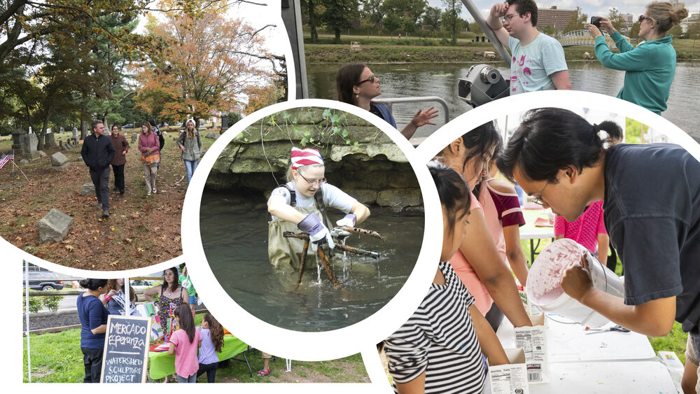
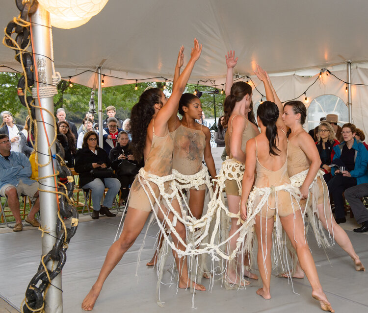
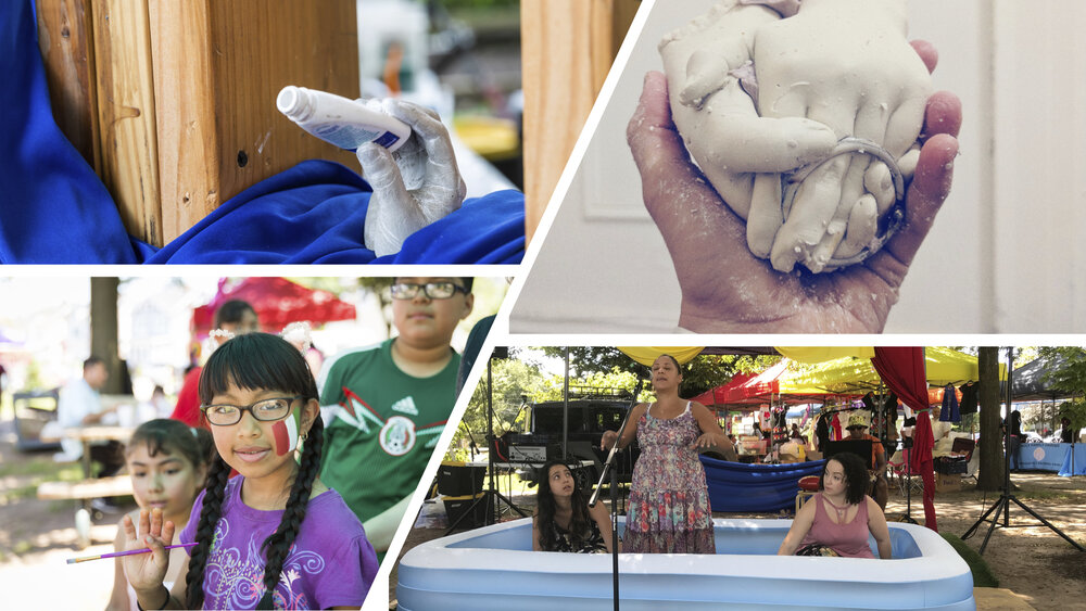
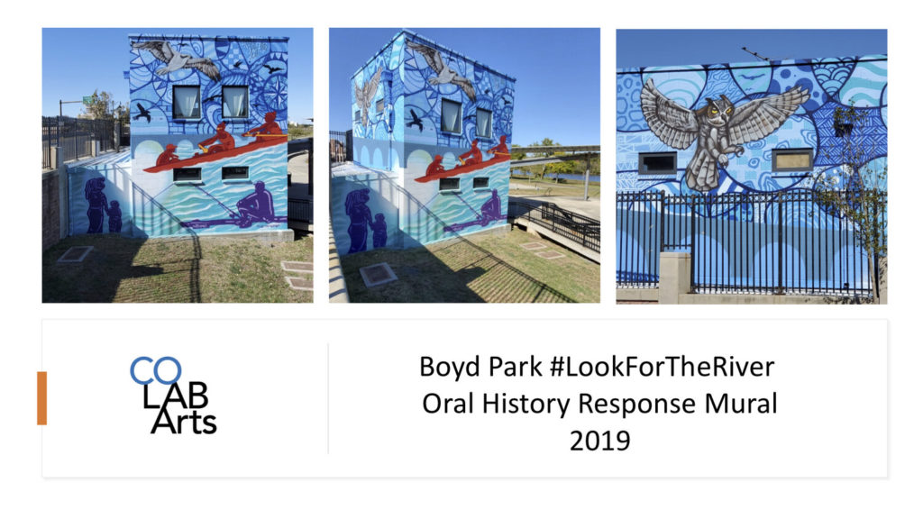
We began work in earnest. Going alongside the LRWP on stream clean ups. Participating in macro invertebrate trainings, touring spaces and landscapes that maybe weren’t the most obvious places of water stewardship. We began engaging professional artists through programs like our National Endowment for the Arts funded residencies where we partner an artist with a non-arts based organization and task each with creating an engaged arts project that facilitates a conversation with community that generates new works of art inspired by some big problem or question that advocacy org is wrestling with. The model of that residency which now has multiple artists with a diverse group of organizations is successful in no small part to LRWP piloting that program our first year. Our Watershed Helping Hands Sculpture Project on display in the lobby is one such example of one of the community based art engagement programs that resulted from that artist residency.
Once the communities have been engaged and you have built a critical mass of participation. You have to think next steps.
At the end of the day we are an arts organization and the greatest way to partner with artists is to provide opportunities for them to create bold artistic gestures.
Our work has been both conceptual and literal.
We have used the process of cleanups, data collection and public access as our points of inspiration to create works that both reuse found materials as well as engage with artists from diverse backgrounds and disciplines such as sculptural work, dance, theater, and mixed media.
To integrate both professional arts creation with community arts creation. Recognizing that while not everything can be called great art, great art can come from anywhere. We balance the ethereal of the performative with the substance of created artifacts; both a natural growth from a new communal education on watershed health and quality and the provocation of a call to action.
When this happens a new kind of reality might be possible. Where if we truly look for the river in all of the aspects of our lives. We begin to question why is it absent? And we see our spaces built in essence to do whatever they can to keep the river out. To blot it out from our landscape…
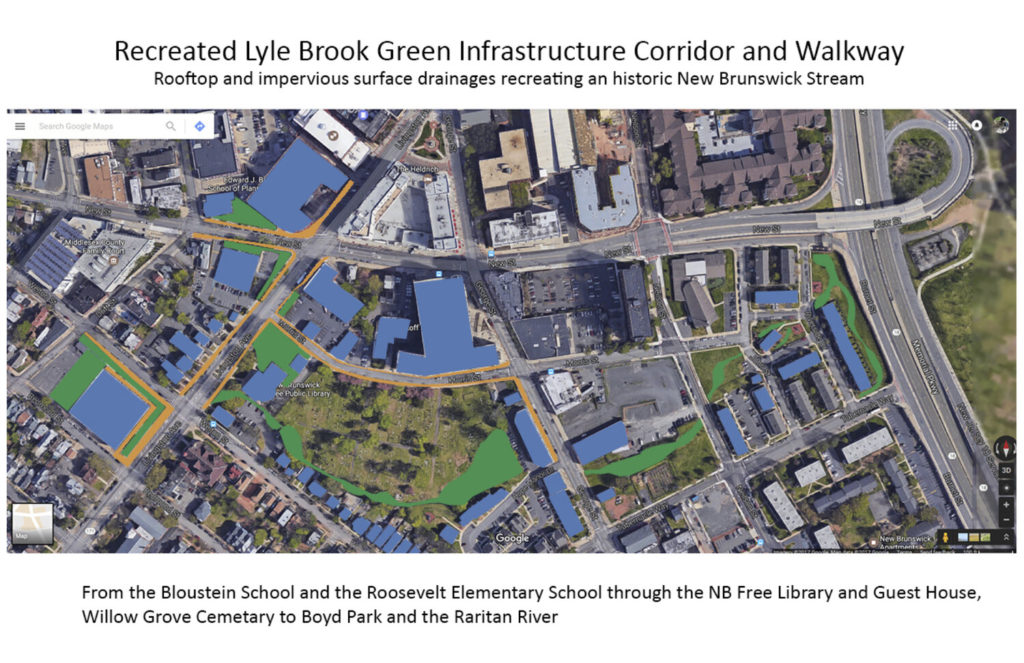
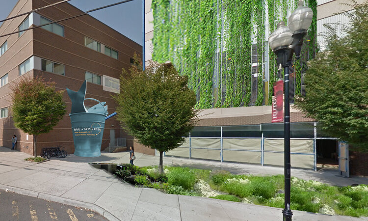
But when you create the potential for new vision we can inspire ourselves, our planners, and political leaders to reintegrate the river into our lives; into our built cities, and our story telling. Accepting the river back becomes our way of solving infrastructure problems. Like a new art and history based greenway connecting public spaces through the heart of an urban area, or an art and green infrastructure concept project which includes a two-story sculpture work that becomes a wayfinding landmark, urban beautification, and a five thousand gallon cistern to keep water run-off from reaching the storm water system in times of flooding.
When empowering communities to create art that allows them to connect with both their environmental and social justice history we can make space to dream about ways in which we can work with our built communities to remember the landscape of our past. And find new ways to interact with it.
The arts are in incredible communicative tool. But the first act of social justice is to listen. Our creations cannot come before we first strive to listen with the intention of learning. Artists and water experts need to engage in this process together. When the artist is involved in the process – not just brought in at the end to slap some paint on a wall, not just asked to develop the PR or marketing strategy, rather allowing the artist to be in response to this listening process.
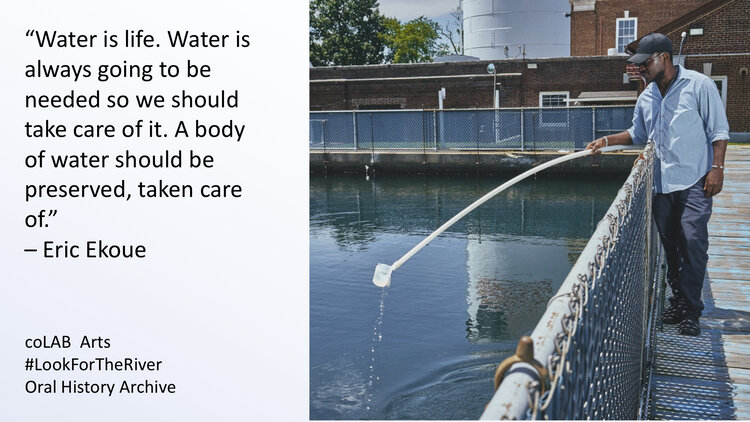
In 2019 we began an oral history archive which is about capturing those stories. Balancing the narratives. We research and collect the stories perhaps lost, perhaps suppressed, perhaps forgotten, around one very simple idea: Water is everywhere, and water is important to everyone. And then doing what we do… make are that is in response and helps us all frame a greener future.
Many thanks, and huge congrats, to LRWP Board Member Johnny Quispe for coordinating grant development for support through NFWF’s 2019 Coastal Resilience Fund.
It was announced earlier this week that $249,639 in National Fish and Wildlife Foundation (NFWF) funds will go to develop the “South River Ecosystem Restoration and Flood Resiliency Enhancement Project (NJ)”.
More specifically, these monies will support Princeton Hydro and other watershed partners to:
“Conduct an ecosystem restoration site assessment and design for 165 acres of tidal marshes and transitional forest in New Jersey’s Raritan River Watershed. Project will result in an engineering plan with a permit-ready design to reduce coastal inundation and erosion along about 2.5 miles of shoreline for neighboring flood-prone communities and enhance breeding and foraging habitat for 10 state-listed threatened and endangered avian species.”
More information on the specific awards can be found here:
Interview by April Callahan, Rutgers Raritan Scholar
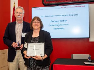
Doriann Kerber is Councilwoman for the Borough of Milltown, NJ, and serves as Treasurer for the Middlesex County Water Resources Association. She is also active with Jersey Water Works, and with the Milltown and East Brunswick Green Teams. She took time out of her busy schedule for an interview about Green Infrastructure outreach in the watershed, and her vision for improving environmental education to benefit the health of our watershed communities.
Doriann Kerber receiving the Sustainable Raritan River Initiative 2019 Award for “Outstanding Achievement in Stewardship” for the Lower Raritan.
AC: Where are you
from in the Lower Raritan Watershed? In your time here, how have you engaged in
and explored the area?
DK: I am from Milltown and we have a sub-watershed, Lawrence
Brook Watershed, that I enjoy exploring. In 2014 I volunteered to be on the
Middlesex Water Resources Association and I heard about the Lower Raritan
Watershed Partnership. I feel strongly about cleaning up the waterways just
like anyone else in my town, and feel that we should all take part in caring
for our waterways. I got involved with the LRWP to do just that.
AC: What, in your
opinion, are the primary issues that need to be addressed in the watershed?
DK: Continuous cleanups are important for all areas of the
watershed. Every town in the watershed should have annual clean-ups! And
education/outreach is so important. We need folks to understand that the land
use choices they make, that their consumption and disposal choices affect their
water and environment. If they want cleaner water and a better quality of life,
then they need to make good choices and help take care of our waterways.
AC: What is your
vision for the LRWP?
DK: I will be assisting with cleanups, but also helping with
outreach events. I want the organization to get more media coverage, more speaking
engagements, and attract more people from all walks of life to enjoy bicycling,
walking, our natural spaces.
AC: I understand you
are training with Rutgers Cooperative Extension to deliver Green Infrastructure
outreach for area municipalities. Can you tell me more about that?
DK: Rutgers Cooperative Extension offers a “Green
Infrastructure Champion” training Program, which I went through. This training allows
me to be able to assess green infrastructure in towns and municipalities. For
example, I met with the General Manager of the Brunswick Square Mall to discuss
stormwater management improvements that will also make the area more
attractive. I have training to assist four different groups: resident,
commercial, government and nonprofit. In addition to working in Milltown and
East Brunswick I can work throughout Middlesex County and the Lower Raritan
Watershed.
AC: What do you see
as the most important actions Town Council members can take in their home
communities to improve overall watershed health?
DK: Environmental education and outreach is so important. We
need Town Councils to show how everybody plays a part in improving watershed
health, and give them the tools and know-how to make a difference. It’s not
just the town, or the water treatment center, or the wastewater treatment
center that is responsible for water management. Everybody plays a role!
AC: Is there anything
else you would like to add?
DK: I think the Lower Raritan Watershed Partnership has
really grown in the last four years. I want it to be recognized throughout the
county and throughout the state, and hope that the work we do will get more
people involved in their local watersheds.
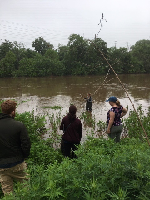
Many thanks to our great team of volunteers who dedicated their Thursday to sampling for fecal coliform and enterococci at six non-swimming beach public access sites along the Raritan River.
Enterococci levels are used as indicators of the possible presence of disease-causing bacteria in recreational waters. Such pathogens may pose health risks to people fishing and swimming in a water body. Sources of bacteria include Combined Sewer Overflows (CSOs), improperly functioning wastewater treatment plants, stormwater runoff, leaking septic systems, animal carcasses, and runoff from manure storage areas. Enterococci levels are often high after heavy or consistent rainfall.
Enterococci results are reported in Colony Forming Units or CFUs. Enterococci results are reported in Colony Forming Units or CFUs. Suitable levels should not exceed 104 cfu/100mL.
Site Name
Time
Enterococcus (CFU)
Riverside Park (40.54067, -74.51219)
9:51
TNTC
Rutgers Boathouse (40.48826, -74.43384)
10:32
TNTC
Edison Boathouse (40.48769, -74.38409)
11:09
TNTC
Ken Buchannan Waterfront Park(40.47483, -74.35586)
Monitoring at Riverside Park in Piscataway 5.30.2019. Photo by Jim Hearty
Please note that while we follow quality control measures, the real-time nature of data delivery means that EPA has not reviewed, and these are not technically quality controlled.
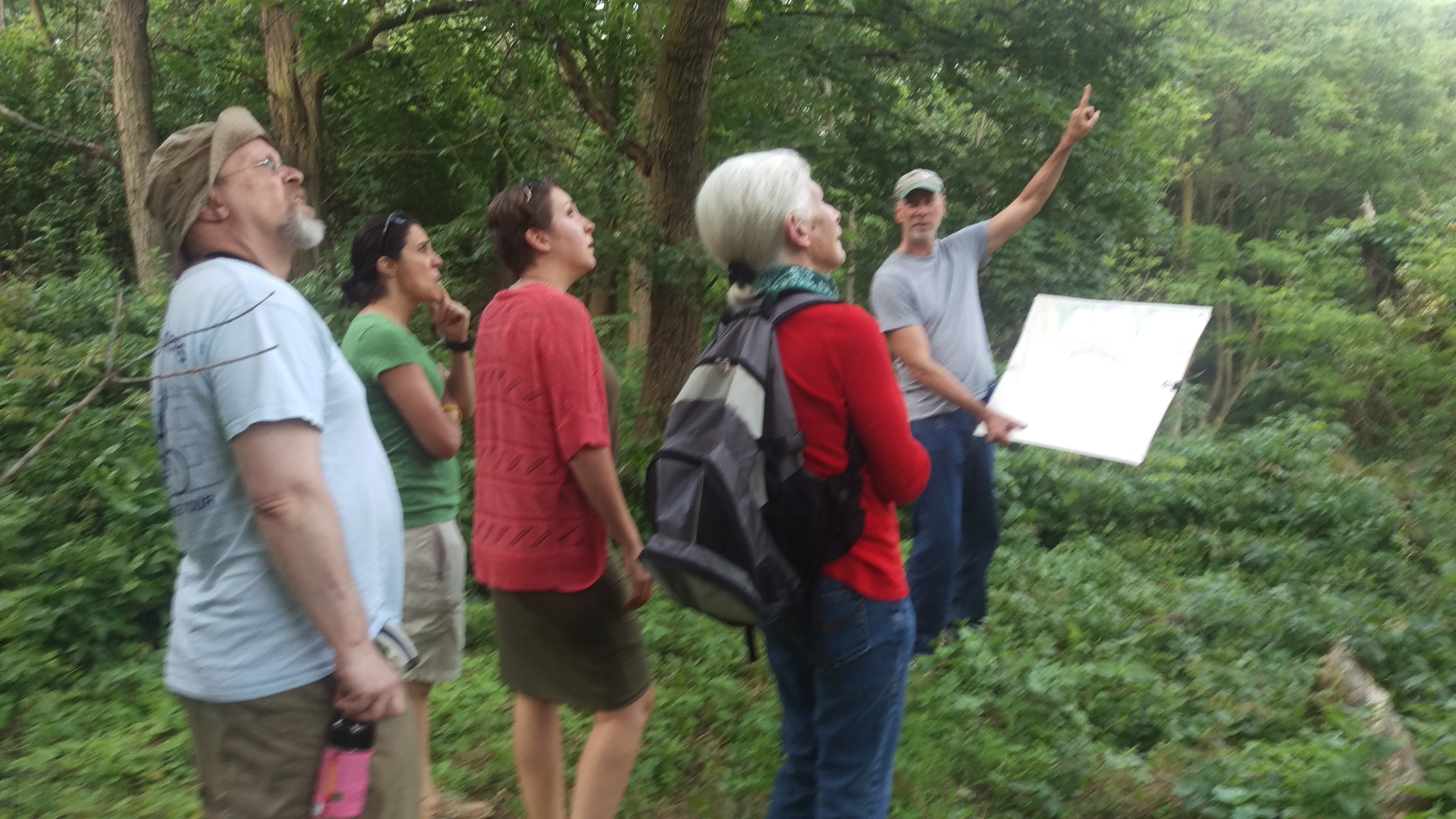
A BioBlitz is an event that focuses on finding and identifying as many species as possible in a specific area over a short period of time. At a BioBlitz, scientists, families, students, teachers, and other community members work together to get a snapshot of an area’s biodiversity.
On June
8 the Lower Raritan Watershed Partnership (LRWP) and partners including the
Americorps Watershed Ambassadors Program, New Brunswick Environmental
Commission, North Brunswick Environmental Commission, and Elmwood Cemetery will
host a day long BioBlitz of Elmwood Cemetery in North Brunswick.
Elmwood
Cemetery is a special forested habitat refuge nestled between the urban New and
North Brunswick communities. The Cemetery was established in 1868 as a “Victorian
Garden Cemetery” during the rural cemetery movement, and to this day all of
Elmwood’s lanes and paths are lined with evergreens and flowering native trees.
Cemetery managers are building on this legacy of careful planning and land
protections to secure Arboretum accreditation, which will allow them to further
advance the planting, study, and conservation of woody plants and trees in
the area.
Our BioBlitz will include public talks by expert naturalists about local natural history, and a chance for the public to work with these experts in an active survey of mammals, fish, plants, insects, aquatic invertebrates, birds and fungi. Our expert scientists will be stationed at various locations at Elmwood Cemetery to help participants engage in unique research. These scientists are our “team leaders.” We use teams to help organize the science and logistics so that we get as accurate a count as possible of the biodiversity of the area.
Our Expert Scientists:
Brionna Primiani (mammals), Wildlife Specialist with New Jersey Wildlife Services
Chuck Sedor (fish), New Jersey’s Division of Fish and Wildlife in the Bureau of Freshwater Fisheries
Michele Bakacs (plants), Cooperative Extension of Middlesex County
Trisha Nichols (insects), Philadelphia Insectarium and Butterfly Pavilion
Von Scully (aquatic invertebrates) NJ Watershed Ambassadors
Laurie Gneiding (birds), NJDEP Ornithologist/Ecologist; NJ Audubon Society
Randy Hemminghaus (fungi), The New Jersey Mycological Association
Article and photos by “Voices of the Watershed” Contributor Joe Mish
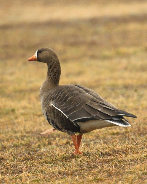
A white fronted goose, rarely seen west of the Mississippi river, enjoys grazing on central New Jersey grass.
Long before President Eisenhower signed the interstate highway bill into law in 1956, The Atlantic, Central and Pacific flyways served as major superhighways for migrating birds.
The primary exit ramps for these super flyways are the rivers which radiate out along the north-south migration routes to distribute the migrating birds far and wide.
New Jersey sits directly on the Atlantic flyway, bounded by the Delaware River and the Atlantic Ocean. Within the state’s interior flows the Raritan River, the longest inland river in the state which serves as a major migratory off ramp.
The confluence of the North and South Branches may then be considered the prime visitors center and rest area, as birds funnel down the Raritan to disperse inland.
Look at a colored distribution map in any bird book and discover that many species are specific to defined regions.
You might not expect to see a rufous hummingbird from the northern Pacific coast, sipping nectar in central New Jersey. However, in 2012, a rufous hummer showed up in our midst and stayed the winter, surviving by the kindness of human intervention. Marlene Scocco reached out to this wayward hummer providing food and shelter, causing a stir in the birding community which gratefully documented this migratory anomaly.
Checking the records for rare hummingbird visitors to New Jersey, other hummer species like the calliope and green violet eared were also documented.
How these birds end up on the east coast is pure speculation. The point is they do and they are here for you to discover.
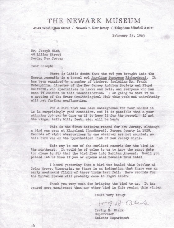
Feathered visitors from faraway places to the Raritan valley are not just limited to hummingbirds. In 1963 I was handed a small owl taken from a guard tower in the Raritan arsenal. It died shortly after. I mentioned this to a friend’s dad who was an avid bird watcher. Told him it was a boreal owl. He smiled and assured me it was probably a saw whet owl. We ended up at the Newark Museum and showed it to the curator, Irving H. Black. Confusion ensued and experts from across the country were consulted. The experts concluded the bird was indeed a boreal owl. It set a new record for the southernmost sighting in the US. The boreal owl, briefly known as the Richardson owl, is a fulltime resident of the coniferous forests of the arctic region. The owl is preserved as a study skin at the Newark museum.
The visitors keep coming. In mid March of this year I noticed an inconsistency in the color pattern of a flock of grazing geese, as I drove by. The geese blended together in one giant mosaic, painted with repetitive splashes of black, white and brown. I pulled over and focused on the colors that didn’t belong.
I was looking at a white fronted goose, another bird that was obviously unfamiliar with distribution maps found in bird books.
The white fronted goose is rarely seen east of the Mississippi river, the main artery of the central flyway. To see a white fronted goose in central NJ is therefore an unexpected surprise and evidence that nature has a tendency to violate scientific generalizations.
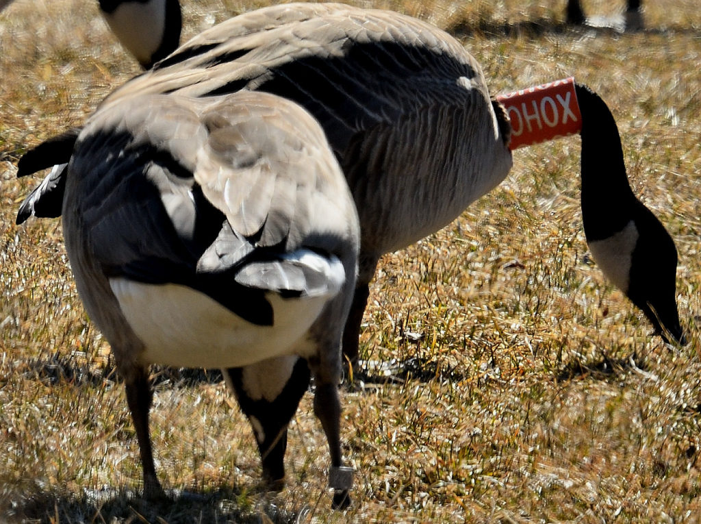
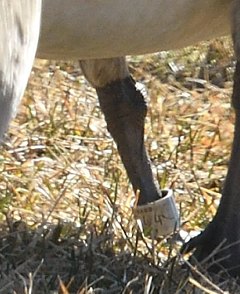
The following week, a Canada goose with an orange and white collar marked OHOX was observed along rt 22. It also had a metal band on its left leg. While editing images, I was shocked to see the goose standing next to it also wore a leg band. Reporting this goose to the USGS bird banding website I was provided with a certificate noting that the goose was a female, banded as a flightless gosling near Varennes, Quebec, Canada on the Fourth of July, 2016.
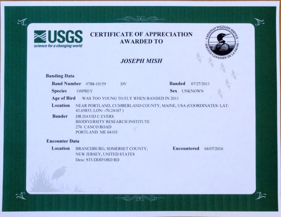
Adding to the distinguished list of local visitors was the osprey I observed April 7, 2016, just upstream of the confluence of the North and South branch. The osprey had a blue plastic band on its left leg, with stacked letters, DV, visible on one of the images taken. Again, making a report to the USGS banding website, a certificate soon arrived, stating the osprey was born on a bulkhead in Portland, Maine and banded on July 27, 2011. To report a banded bird, visit the USGS bird banding website, bandreports@usgs.gov
The spring migration is now in full swing. And along with colorful warblers, ruby throated hummingbirds, woodcock and osprey, come the errant travelers.
Diverging from their evolutionary migration patterns, these intrepid winged visitors explode the myth that, “birds of a feather stick together”.
Migrating birds that nest in our region, along with birds just passing through, are now appearing along our waterways. The confluence that forms the Raritan River is the staging area that hosts a feathered extravaganza of unimaginable variety.
Author Joe Mish has been running wild in New Jersey since childhood when he found ways to escape his mother’s watchful eyes. He continues to trek the swamps, rivers and thickets seeking to share, with the residents and visitors, all of the state’s natural beauty hidden within full view. To read more of his writing and view more of his gorgeous photographs visit Winter Bear Rising, his wordpress blog. Joe’s series “Nature on the Raritan, Hidden in Plain View” runs monthly as part of the LRWP “Voices of the Watershed” series. Writing and photos used with permission from the author. Contact jjmish57@msn.com. See more articles and photos at winterbearrising.wordpress.com.
Thirty years ago, my husband and I moved into a house down at the end of a quiet street in Highland Park. Beside the house, in a low area, ran a little stream, nameless as far as I knew. I imagined making a garden beside it until I saw the muddy water that rushed through after heavy rains, rooting out vegetation, clawing away at the stream banks, and depositing all manner of storm debris. I came to think of the stream as nothing but a source of problems. Years went by. I sought advice from various experts and made some progress in resolving some problems, though others remained.
Eventually, in the Rutgers Environmental Stewardship program, I learned that the problems of urban streams are predictable and can, at least in theory, be mitigated. I learned that, with active community involvement, even large rivers have been significantly restored. The RES program led me to the Lower Raritan Watershed Partnership and a plan to document the stream that I now knew was called Mill Brook.
I took pictures and made lists of storm sewer outfalls, eroded portions of stream banks, retaining walls in various states of disrepair, and multiple types of litter, wondering how this information about predictable problems might be useful. Increasingly, my attention was caught by the magnificently tall trees in the Mill Brook stream corridor, the bird song high above me, the calming gurgle of the water at my feet, and the sense of being far away while actually only a few yards from the hubbub of one of the most densely populated regions in the United States. I have learned that Mill Brook has been a source of much happiness for others, too, over the years.
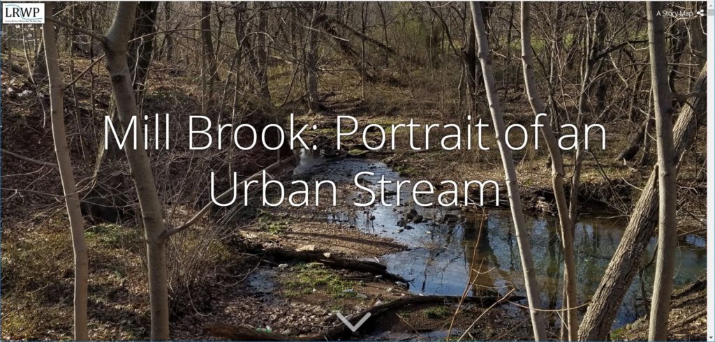
I composed this Story Map Mill Brook: Portrait of an Urban Stream to invite you, the reader, to experience for yourself this valuable natural resource that runs like a ribbon through our community. I hope that a virtuous circle may arise in which the value of Mill Brook is acknowledged in our communities so that we willingly do what it takes to resolve problems created by developments that include our own homes. In return, Mill Brook will increase in value to us because it is a healthier natural resource and because we will have the satisfaction of caring for it.
Article and images (except as noted) by Sanja Martic, Rutgers Department of Landscape Architecture Graduate Student.
“Man wants to take the river’s natural storage reservoir and make no compensation for it. The river contends it is against Natural Law and cannot be done. The river is right.” James P. Kemper, New Orleans, 1927.
The Dutch Room for
the River Program (RfR) was conceived in 2007 as an integrated river basin
management strategy for the low-lying flood prone and densely populated areas
of the Netherlands. As part of this Program, water management is conducted via
a specialized regional “Water Board,” working in partnership with the Dutch
National Ministry and the Ministries for Transport, Public Works and Water
Management. Through RfR the Dutch Water Board takes a four-pronged approach to
water management. The four key characteristics of the RfR approach include: 1)
large scale river region landscape architectural design thinking; 2) a focus on
collaboration, with landscape architecture playing a facilitating role; 3)
considering the landscape as a system of layers; and 4) anticipating that
natural processes will change and enhance the design over time.
As in the
Netherlands, significant portions of New Jersey’s Lower Raritan River are in
low-lying densely populated areas. Flood protection is of paramount importance
and a matter of human safety and economic security. However, the Home Rule
focus of New Jersey’s local governance limits the potential for thinking in a
landscape context, no comparable “Water Board” serves as coordinating entity
for water management, flood control prioritizes human land use layers, and
engineering controls trump considerations of natural hydrological processes and
flows. There is much to learn from the Dutch RfR example. In what follows we provide
background information on RfR, and consider the Dutch Water Management approach
in the context of New Jersey’s Raritan River and Lower Raritan Watershed.
Historic Approach to River Basin Management
In riverine areas
around the world, the industrial revolution demanded capitalization of the river’s
territory and its water. As a result, many river basins were heavily
engineered: rivers streamlined, river basins minimized, and creeks and small
streams culverted or replaced by canals[1].
These practices, in combination with development over time, resulted in
floodplains that restricted the river and required repeated heightening of
flood defenses[2].
There was no appreciation for the river ecosystems, and water was seen as a
threat and as something that needed to be controlled. Over time, conflicts arose
regarding use of the floodplain and the its water. And the Industrial
Revolution and subsequent development left behind a lasting pollution legacy:
abandoned infrastructure and degraded water and soil quality. Meanwhile, the
expanding population’s need for potable water and space for a safe habitation increased,
causing a decline in the river basin surface. In recent years, rising intensity
and quantity of extreme precipitation events associated with a changing
climate, coupled with increase of the impervious surface cover, further
complicate water management issues.
Room for the River (RfR) Emergence and Approach
In the Netherlands, traditional water management methods were challenged following destructive floods in 1995, caused by record extreme precipitation events. It was clear that new flood levels required a different approach towards river management. Different approaches to water management call for different methods: many rely heavily on engineering while others emphasize a more natural approach. Room for the River Program (RfR) finds a middle ground. Instead of gradually reducing the area that rivers occupy, this approach allows the river to expand over a larger territory[3]. RfR brings together the worlds of water management and spatial planning, engineering and ecology. Tools are varied and include dredging at one extreme, and measuring spatial quality on the other, and they are put into service of two main objectives: improving safety by reducing flooding of riverine areas, and “contributing to the improvement of spatial quality of the riverine area”[4]. Although hard to quantify, this second goal is particularly interesting from the landscape architecture perspective as it considers quality of the space.
Spatial quality
within the RfR approach is defined as “a property of the resulting landscape
after a plan has been implemented.”[5]
A good design is further judged by three criteria: hydraulic effectiveness,
ecological robustness and cultural meaning and aesthetics. Cultural meaning and
aesthetics criteria call for enhancing the scenic beauty, tailored to a range
of sites that could be classified as natural, urban or countryside. Ecological
robustness endorses designs that are long lasting, self-sustained, build upon
natural processes, and are low maintenance. This is achieved through combining
natural hydrology with morphological and biotic processes to achieve stability
in riverbed and floodplain.[6]
This means that plans have to be functional in the case of floods, but at other
times must accommodate livability, wildlife habitats and areas usable as a public
good. Design is informal and natural while providing maximum access for recreation,
with spaces intended to reveal the spirit of each individual site of
intervention.
Room for the River (RfR) Implementation and Practical Measures
In the Dutch
model, spatial quality assessment requires development of a special Q-team
(quality team) composed of members from different but complimentary
disciplinary backgrounds. The Q-team’s role is to produce an independent
recommendation on enhancing spatial quality through coaching designers and planners,
peer review of the designs and plans, and regular communication to the
Ministries of Transportation, Public Works and Water Management[7].
This calls for significant transdisciplinary cooperation between planning and
design, with an equal role for the landscape architect, urban planner, river
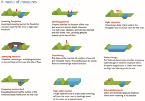
engineer, ecologist and physical geographer. Practical measures (Figure 1) are
applicable at large scale and fall into three categories ranked by complexity
of integration of flood risk measures with spatial measures. These categories
include technical measures (deepening the river bed, lowering groynes,
strengthening dikes), measures within the banks (lowering the floodplains,
removing obstacles), and measures beyond the banks (high-water channel
building, dike relocation, water storage). In addition to evaluating project’s outcome,
the team also evaluates the quality of the integrative collaborative design
process.
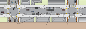
Figure 1: Different types of measures in the RfR program Source: Practical Measures, from Room for the River Fact Sheet
Precedent for RfR in the United States
The RfR approach
is not entirely new to the United States. An early similar effort was forwarded
in New Orleans in 1927, following devastating flooding events in the
Mississippi River delta. Like the Dutch who relied on dikes for flood
protection, the Mississippi delta community relied on constant raising and
enforcing levees, increasingly restricting the surface size of the natural
flood plain. The 1927 flood prompted a reevaluation of the Mississippi River
management approach. Official Congressional hearings were held and involved the
U.S. Army Corps of Engineers, the Mississippi River Commission and expert
witnesses such as Gifford Pinchot[8].
Discussion revolved around engineered control of the river proposed by the Army
Corps of Engineers, and an approach in which nature would be allowed more
leeway[9]
supported by Pinchot, James Kemper and others. The latter view resembles the
RfR approach as it calls for allowing more room for the river through widening the
flood plain.
RfR Methodology
1. Large-Scale Design (Entire river region)
The large scale landscape architectural design approach considers “not only detailing of small-scale elements, but also at the scale of the river system as a whole”. [10]
2. Collaboration
The landscape architect plays a central
role of coordinator between planners, architects and other partners. Fliervoet
and Den Born studied and evaluated the RfR’s collaborative process from a
stakeholders’ perspective. They concluded that the success of the approach is
highly dependent on the cooperation and collaboration of multiple entities
occupying the watershed with emphasis on the local knowledge. The biggest
obstacles to collaboration stated by the participants, were the lack of an
overarching, integrated maintenance vision and a lack of coordination between
the authorities.[11]
3. Considering the Landscape as a system of layers
o Basis of Landscape (soil, water,
ecosystems)
o Network Layer (roads, waterways energy
infrastructure)
o Occupation and Land Use (living,
working, recreation)
o Time Layer (all layers develop within their
own time scale)
4. Creating Conditions: Responding to natural
processes
Natural processes
are expected to change and enhance design over time.
Applying the RfR Methodology to the Raritan
Large-scale Design of the Raritan River Floodplain and
Regional Network
The first characteristic,
the large scale of design as applied to the Lower Raritan, requires creating a
comprehensive masterplan with projects spanning the entire Raritan watershed. RfR
site plans would become small parts of a large Raritan Watershed Masterplan. The
masterplan would be guided by a comprehensive vision of integrated water
management, with a regional greenway connection as an integral part. Directly
connecting the City of New Brunswick to the greenway network would be a key
component of the masterplan, as New Brunswick is the largest settlement on the
banks of the Raritan River. Collaboration between many governing bodies is
essential. At the federal level the governing bodies to involve include USACE,
USCG and the Advisory Council on Historic Preservation. At a state level
governing bodies to involve include NJDOT, NJDEP and Land Use Regulations and
Ecological Services Field Office. Regionally the Delaware and Raritan Canal
Commission and counties such as Middlesex, Somerset, Hunterdon and others
should be involved. At the local level the municipalities along the Raritan
River banks including New Brunswick, Piscataway, Franklin Township etc. would
require representation.
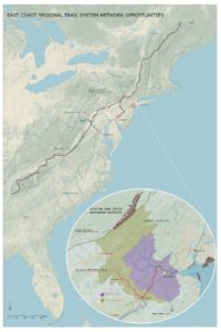
Large scale design requires examination of large-scale network connections. Analysis in the Raritan River context reveals several greenway network opportunities (Figure 2). Metropolitan areas of New York City and Washington D.C. are roughly framed by the Appalachian Trail to the North and the proposed alignment of the East Coast Greenway to the South. They are further enclosed by the major East Coast rivers that bisect the Trail and the Greenway on their way to the Atlantic Ocean. The Hudson River Valley to the East, the Delaware and Lehigh National Heritage Corridor, and the Chesapeake and Ohio Canalto the west all form a regional trail system matrix. This blue and green matrix provides unique opportunities for cross connections of the corridors and interactions with nature and culture to one of the world’s densest contiguous urban populations.
The East Coast Greenway is an aspiring walking and
biking route stretching the length of the US East Coast with southern terminus
in Key West, Florida and northern Maine. Once actualized, the East Coast
Greenway will be 3000 miles long and epitomize the bond between communities and
nature by connecting the exist green open space along its route into a unique
linear corridor. Initiated in 1991, with forming of the East Coast Greenway
Alliance, the vision of Greenway designers, “represents a commitment to public
health, environmental sustainability, economic development, and civic
engagement”[12].
The existing Appalachian National Scenic Trail, which
partially passes along New Jersey’s northern border, is currently the longest
hiking footpath in the world at 2190 miles long[13].
It was first proposed by a regional planner Benton MacKaye in a 1921 document titled “An
Appalachian Trail: A Project in Regional Planning”. MacKaye’s vision initiated the idea of land
preservation for the purposes of recreation and conservation. The idea started to materialize in 1925
and was actualized in 2014 when the last stretch of the Trail was formally
acquired and protected. Today, the trail
is visited by over 3 million visitors a year as it bisects fourteen US States
from Georgia to Maine.[14]
The East Coast Greenway’s proposed alignment crosses
the narrow waist of New Jersey using the D&R Canal Park as a major
junction. Canal Park’s Masterplan recognizes the most important quality
possessed by this linear park to be the role it can perform as a connector.
Canal Park no longer links New York City and Philadelphia, but it does join
central New Jersey communities, different land forms and different kinds of
natural areas, and connects New Jersey with its heritage[15].
Extending the Canal’s connection back into the city of New Brunswick would
align with the Canal Commission’s Masterplan and benefit New Brunswick’s future
development.
The Delaware and Lehigh National Heritage Corridor
runs along the Delaware River on the Pennsylvania side, parallel to the D&R
Canal Park. It is an indirect connection between the proposed East Coast
Greenway, through the D&R Canal Park to the Appalachian Trail. It is also an
example of a linear park run by a nonprofit organization, while Chesapeake and
Ohio Canal is a linear park that is part of the National Park system. The Chesapeake
and Ohio Canal is another significant connector between the Appalachian Trail
and the East Coast Greenway close to a major metropolitan area.
When the Delaware and Raritan Canal was built in the
1930s it permanently linked the Delaware and Raritan watersheds, creating opportunities
for connection. Since that time, construction of Route 18 through New
Brunswick, which established a several mile stretch of roadway immediately
adjacent to the Raritan, severed this historic network connection, in
particular in the area between Buccleuch Park and the Landing Lane Bridge. Today,
the City of New Brunswick’s unique geographic position could once again benefit
future development should access impediments to the D&R Canal Park be
removed, resulting in expanded access to not only Canal Park but regional
networks like the East Coast Greenway. There would be many mutual gains: the local
community would have better access to nature and everyday recreation and
day-hiking without having to drive to the trail. New Brunswick’s rich local
history would add to the richness of the trail’s experience. The local economy
would benefit from hiking and biking traffic generated by the Greenway.
Finally, being a part of the future East Coast Greenway’s shared vision could
be an invigorating driver of the nature stewardship and future community and
economic development.
Figure 2: East Coast Greenway Network Opportunities
Collaboration of Local, Regional, National and State
Partners
Collaboration and
coordination, conducted by a landscape architect, may include working with a
variety of professional partners on a local level. In addition to planners and
architects, other professions to engage include social scientists, geographers,
ecologists, river engineers, biologists, historians, archeologists and civil
engineers.
Considering the Raritan River Floodplain and Watershed
Landscape as a system of layers
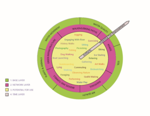
The RfR “system of
layers” approach consists of a base layer, network layer, potential for use
layer and time layer (Figure 3). Layers provide a basis for site evaluation within
the Lower Raritan. Expanding the original RfR methodology, we have conceived of
each of the four categories of layers as worth 25 points for a total of a
100-point evaluation system. The lower the score for specific site, the better
the opportunity for enhancing it.
Figure 3: Adopted Diagram of Layers of Landscape
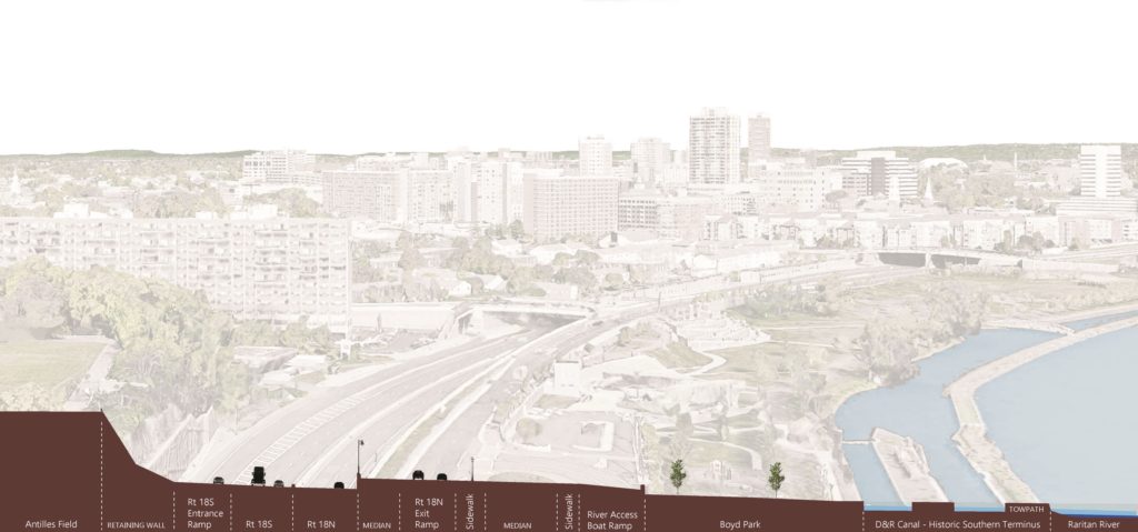
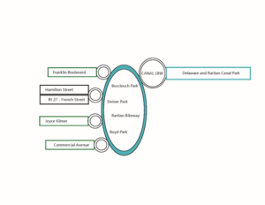
For example, considering New Brunswick in relation to the regional greenway network, the four areas identified as having the best opportunity for creating connections between the New Brunswick and regional greenways are the Key Connector Streets (Urban Core Green and Blue Corridors), Waterfront Access Points, Raritan Bike Path, and the “D&R Canal Link”(Figure 4). These] specific sites should then be evaluated for their soil, water and air quality within the base layer, and for the existing roads, railroads, bridges/tunnels, walking and biking paths and green networks within the network layer. The Network Layer evaluates the existing networks presence and connectivity. Points (0-5) are given for the presence of the networks within the site and more points for their current connectivity. All the sites have a presence of at least one network, however in some cases those networks are enhancing and in others reducing walking and biking connectivity. Increasing connectivity becomes a goal for this layer.
Figure 4: Simplified Connections Diagram
The Base Layer
evaluates the soil, water, air, plant and animal life conditions of the
landscape. 0-5 points for soil quality are allocated depending on its
permeability as well as its ability to support life. In the urban environment
soil is often covered by pervious surface or is heavily compacted resulting in
a low rating. Water movement is evaluated based on the speed of its movement
within the site. Faster movement (poor infiltration) is rated lower. Water
quality is associated with the ability of site to treat the stormwater runoff.
Water that leaves the site cleaner results in higher points. Air quality
depends on the site’s micro location. Sites near major roads with little
vegetation are rated lower. Finally, existence of plant and animal life is
rated depending on a level of presence. Based on the rating, design goals that
emerge are: increasing surface permeability, slowing down runoff by retaining
water in the landscape for longer periods, decreasing soil compaction, and creating
conditions that support more plant and animal life.
Our addition to
the methodology also includes expansion of the “potential for use layer” by
which each of these sites are evaluated for their potential to support any of 25
different activities that could take place within the area once it is
redesigned. The Potential for Use Layer allocates one point for each activity
that can currently take place within an area. The goal for this layer becomes
increasing the number of future potential use of the space.
Finally, the time
layer evaluates presence of historic and cultural artifacts on one end and a
potential for future ecosystem health improvement on the other. Sites that
contain historic and cultural artifacts are rated higher, as well as the sites
that will be able to, over time, enhance the ecosystem health. Ecosystem health
is prioritized over the existence of historic and cultural artifact. For
example, a city street has less potential for the improvement of the future
ecosystem health than the river bank.
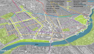
Figure 5: Proposed Connections Diagram
The redesign of
the existing key connector streets within the City of New Brunswick enhances
the biking and walking experience, while leading to the waterfront access
points. Commercial and Joyce Kilmer Avenues are green corridors, chosen for
their proximity to the local schools, green open space, highest population
density and wide traffic lanes. These two thoroughfares have a great potential
for “road diet” interventions, such as narrowing traffic lanes and adding
bumpouts at street crossings in order to calm traffic and thus enhance safety of
pedestrian and bicyclists. They would further create opportunities for bringing
nature closer to the local communities by becoming way finders for the Raritan
River as well as the green corridors with more pervious surface and vegetation
(Figure 5).
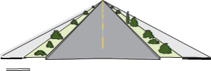
Existing Roadway Surface
Bike lanes, pervious surface
Figure 6: Green Corridor Intervention Source: Oregon Bicycle and Pedestrian Guide
Route 27 or French
Street and Hamilton Street are already main routes of access that are further
enhanced by adding new and improving existing bike lanes, and improving
pedestrian experience by adding bump outs and lowering curbs. Similar
interventions could be applied outside of the immediate study area. Franklin
Township’s Franklin Boulevard is the next such opportunity. The existing Mile
Run stream corridor, in conjunction with the key connector streets, forms a
matrix of river connections. The Mile Run stream corridor is now accessible
through this matrix, offering further opportunities for engagement with water
and nature.
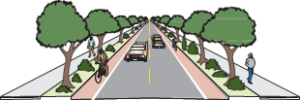
Figure 7: Bumpouts add sidewalk space, provide space for rain gardens, bike parking, etc. and shorten crossing distance. Minimum width lanes slow traffic.
Source: “Main Street: When a Highway Runs Through it”, Oregon Downtown Development Association
Access to the waterfront
is strengthened using various traffic calming techniques such as raised,
textured crossings, lowered speed limit and narrowed traffic lanes. These
approaches ensure safety and an enhanced pedestrian experience. Redesigning the
Raritan bike path by adding access points, widening its surface, and adding
small, localized interventions helps create a sense of place and wayfinding.
Materials and forms chosen for intervention help to further connect community
to the unique industrial and postindustrial history and ecology of the place.
Finally, the “Canal Link” links fragmented biking and walking paths ending
within the area of the River Road, Landing Lane, Buccleuch Park and Spillway,
through an elevated walkway bridging the impediments. This walkway becomes the
final interlocking link restoring connection to the D&R Canal Park, East
Coast Greenway and the Raritan.
A final key characteristic of the RfR program requires considering how including natural change over time can be integrated in the designed system, so that it could start functioning as a natural system. Within the landscape architecture field, time is always an important element considered in designing a landscape. The question: “How will a landscape change throughout the years?” is a core design consideration. However, change is usually considered as it relates to human use and needs. In the RfR case the emphasis is on the health of the entire ecosystem, and the ability of landscape to be “managed” by natural processes, thus making it self-sustained and supportive for all living beings. Choices of materials and forms should be made considering this final concern.[
[11] Fliervoet,
van den Born, and Meijerink, “A Stakeholder’s Evaluation of Collaborative
Processes for Maintaining Multi-Functional
Floodplains.”,p 185.
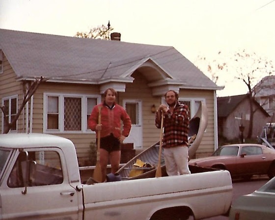
As elated as Lewis and Clark upon reaching the Colombia River, Jimmy and I proudly pose with our intrepid craft , “The Wild Turkey”, in the back of an old Ford Pickup
The eternal waters of the South Branch flow with memories and reflections, kept safe for those who have opened an account along its banks and written their story upon its waters.
I have a longstanding account, opened years ago, from which I make occasional withdrawals. The memories are recalled, polished with reflection and returned for safe keeping.
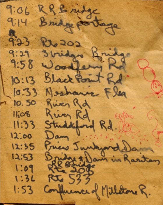
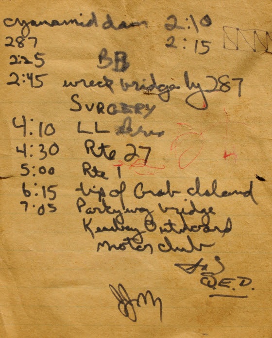
Hazy events, prompted by a scrap of paper that fell from one of my books, brought a canoe journey made decades before, into sharp focus. The lined, yellow paper, in my handwriting, was a record of time and places noted on a trip down the South Branch to the sea with my good friend Jim Serchio.
Jim worked across the hall from me in the pharmacology department at J&J. Intrigued by my stories of paddling solo to the mouth of the Raritan River; Jim recruited himself to join me on another run to the sea.
A hasty plan was hatched and a day chosen. We would launch from Main st in Clinton and paddle down to Keasbey. I would then walk to ‘Billy Vack’s Loop In’, an old iron workers bar located under the Parkway bridge, phone my brother-in-law, and get a ride in his pickup truck to my parent’s home, about three miles away.
The chosen canoe was my old canvas covered 1910 Old Town OTCA 16 named the “Wild Turkey”. Now stripped of canvas and covered with fiberglass, the hull was painted a flat, dead grass green and weighed in at about 85 pounds.
No cooler, just a couple of blue cushions and two guys in the canoe headed downstream. Jim was brilliant guy, studying biomedical engineering. I suppose it was his scientific inquisitiveness which finally prompted him, once we were underway, to ask, how long would the trip take. In my best carefully calculated estimation, I answered, “pretty much all day, we should be there before dark”.
As we passed under interstate 78, just after launching, I noted the time on my scrap of paper. Every time we passed a landmark, clock time was recorded.
Route 202 was reached at 9:23 am.
Looking over the sequence of shorthand notes, I now realize we had paddled under and over landmarks that are now gone or restored differently from their original form. Many of the metal bridges have been reconstructed over the years, their fieldstone supports now replicated by fieldstone veneer. I counted five bridges between Clinton and rt 31. The old dam we portaged below Dart’s mill is now essentially washed away. One bridge downstream of Neshanic station was not yet constructed. The scenery on the same trip today would be quite different.
Route 206 was reached at 1:09 pm
One entry made at 2:45 just before the second downstream pass under interstate 287 makes me smile; I wasn’t smiling then. I recorded the word ‘surgery’.
There was the wreckage of an old wooden bridge just before the last pass under I 287. It blocked our passage so we had to go up and over. As we set the heavy boat down on the rough planks, we did not see a huge spike that punctured the hull below the water line on the starboard side. The situation was looking grim as we were about to enter tide water on the last six hours of the trip. This meant navigating a running tide and staying clear of the main channel to avoid the large wakes churned up by tugboats and deep hulled pleasure craft.
Undaunted, we set the boat back in the water and began down river to see how bad the leak was. It was bad, real bad. How were we possibly going to finish. Pulling to shore, we looked around the debris, left by high tide, for a possible solution. Seeing a piece of yellow polypropylene rope, I had a flash of brilliance. As a kid I loved playing with fire, burning all sort of material including little plastic soldiers. The drops of melting plastic would quickly cool to form rock hard globs and even make a neat hissing sound as it dripped. On a hunch, I took the piece of rope, set it ablaze and dripped the plastic into the large hole in the hull. A perfect watertight fit and we were on our way.
At 4:30 we passed under rt 27, the low water encountered from 287 to Landing Lane Bridge road really slowed our progress. Now we had to deal with the wakes of large watercraft, which showed no mercy to two guys in a canoe. The resultant waves forced us to divert course, turn the bow into the wake and then re-correct to head downriver.
We passed the old drydock across from Crab Island at 6:15 and finally reached our destination under the New Jersey garden state parkway bridge, the former site of the Keasbey Outboard Motor Club, at 7:05pm.
While Jimmy entertained the bystanders, I headed up to Billy Vack’s to call my brother-in-law.
When I returned to the boat and Jimmy, someone asked where we put in. We were actually embarrassed to say, Clinton. We figured they wouldn’t believe us.
Our ride soon arrived and we could finally relax. We did it! Paddled from the NJ highlands to the Mouth of the Raritan river in about 12 hours in a 1910 Old Town canoe pressed into service for an epic journey to the sea.
Jimmy passed away a few years later from a medical procedure gone badly.
I still have the canoe and think fondly of the epic river journey shared with my good buddy Jim. The diary of times and places serves as a reference for memories and the ever changing river landscape.
Two of three pages from the ship’s diary, documents the journey of “The Wild Turkey” and its crew, serves to sharpen the memory of a dash to the sea by two friends in a turn of the century canoe.
Author Joe Mish has been running wild in New Jersey since childhood when he found ways to escape his mother’s watchful eyes. He continues to trek the swamps, rivers and thickets seeking to share, with the residents and visitors, all of the state’s natural beauty hidden within full view. To read more of his writing and view more of his gorgeous photographs visit Winter Bear Rising, his wordpress blog. Joe’s series “Nature on the Raritan, Hidden in Plain View” runs monthly as part of the LRWP “Voices of the Watershed” series. Writing and photos used with permission from the author.