The Lower Raritan Watershed Partnership and Rutgers Cooperative Extension of Middlesex County run a volunteer pathogens monitoring program from May to September every Summer. On Thursdays we collect water quality samples at 6 non-bathing public access beaches along the Raritan River, and report the results on Friday afternoons. See here for more information on our pathogens monitoring program.
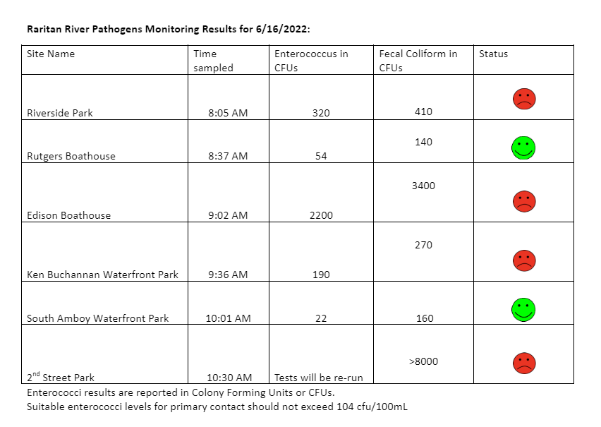
Our monitoring results for June 16, 2022 are somewhat better than previous weeks, however we received about ½ an inch of rain while we were out in the field doing the sampling, which means that bacteria levels are most likely higher than test results indicate.
Enterococci results are reported in Colony Forming Units or CFUs. Suitable levels for primary contact activities (directly touching the water) should not exceed 104 cfu/100mL. Pathogens/Enterococci levels are used as indicators of the possible presence of disease-causing bacteria in recreational waters. Water samples taken at sites with green “smiley faces” are below federal Environmental Protection Agency (EPA) threshold for Enterococcus. Water samples taken at sites indicated with red “smiley faces” were above federal EPA threshold for Enterococcus and suggest potential health risks from pathogens. Pathogens may pose health risks to people fishing and swimming in a water body. Sources of bacteria include Combined Sewer Overflows (CSOs), improperly functioning wastewater treatment plants, stormwater runoff, leaking septic systems, animal carcasses, and runoff from manure storage areas. Please enjoy our waterways at your own risk!
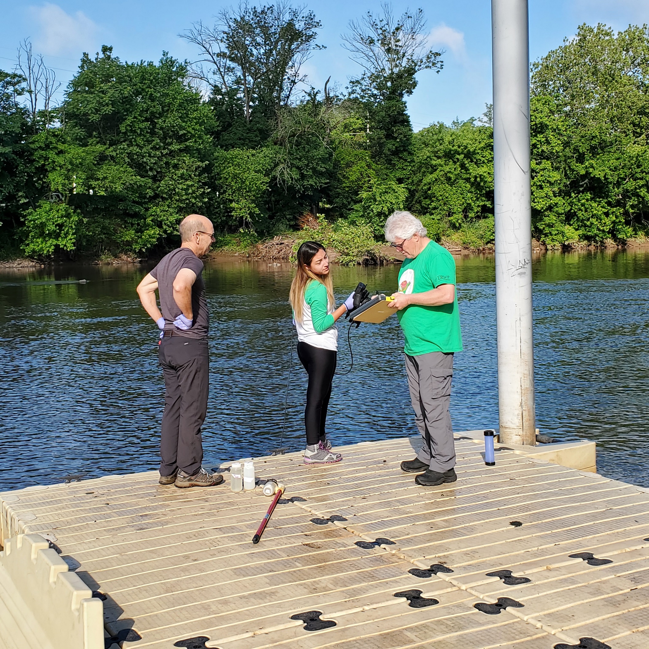
Big thanks to our partners, Rutgers Cooperative Extension of Middlesex County and Interstate Environmental Commission, and to this week’s monitoring team Frank Dahl and Andrew Gehman, and of course to our Monitoring Outreach Coordinator Jocelyn Palomino.
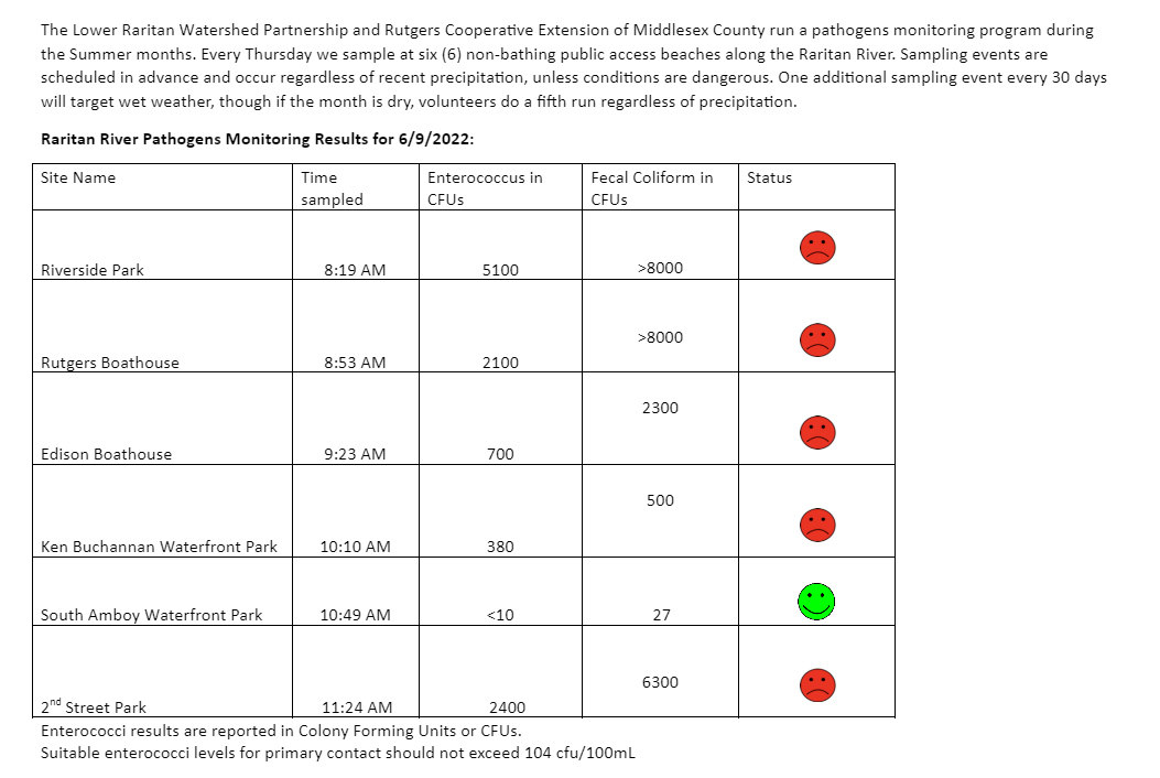
With 0.83 inches of rain on Thursday morning June 9, you can probably guess the water quality vibes! High Enterococcus levels at almost all our pathogens monitoring sites this week (read about the exception below) means Raritan River lovers should be wary of engaging in waterfront activities this weekend.
Our Perth Amboy site was especially gross. Water Quality monitoring after heavy rains near combined sewer overflows (CSOs) is never pleasant. Look closely at the waterline in the photo below. What you see is several inches of pulverized toilet paper, disposable wipes, and poo defining the water’s edge at our 2nd Street Park Perth Amboy site. There was active discharge of sanitary sewage from the CSO, the pipe in the middle right of the image. Any guesses as to the dominant odors?
Perth Amboy Waterfront 6.9.2022
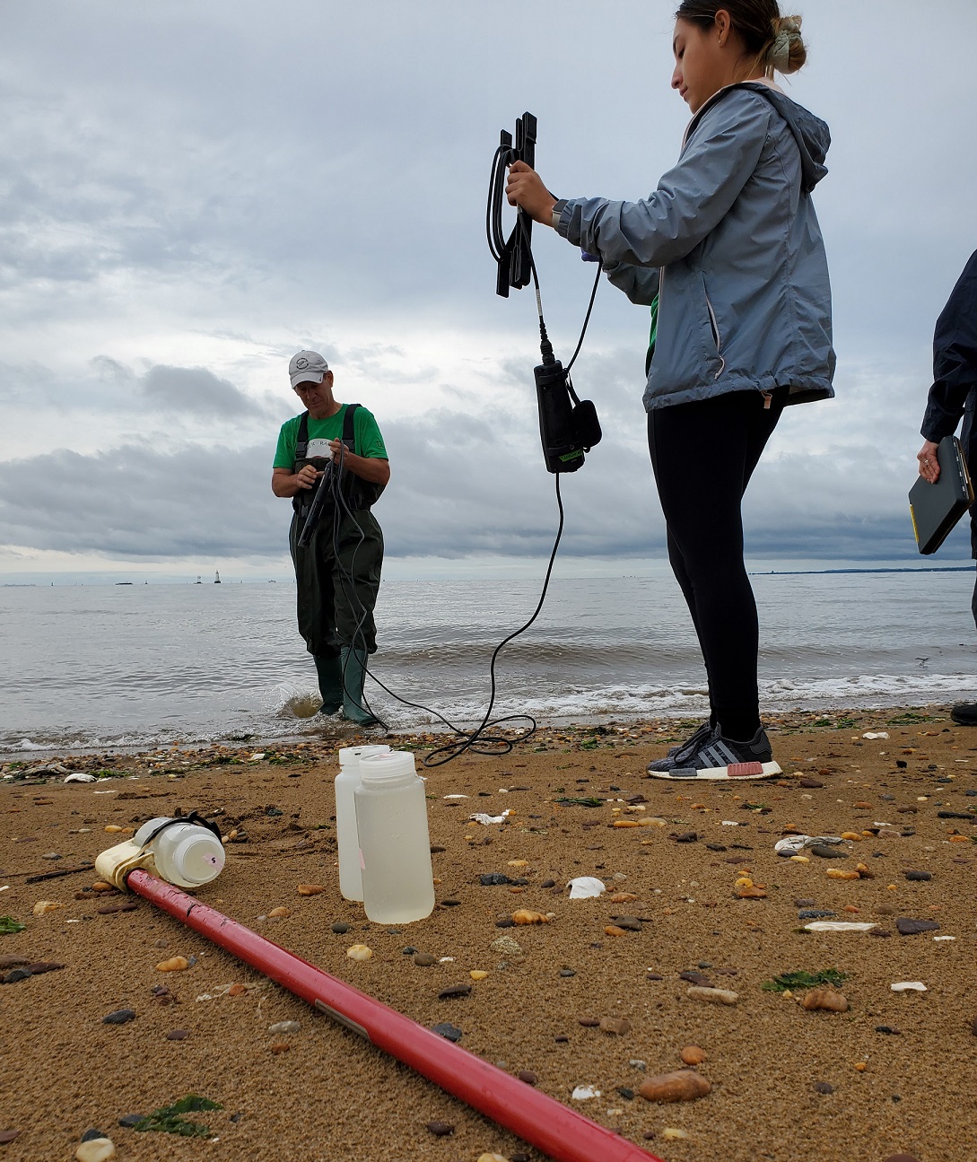
Despite the yuck factor, it was a GORGEOUS day to get out for some sampling. Huge thanks to our crackerjack team including the LRWP’s Community Outreach Project Manager Jocelyn Palomino, and our volunteer monitors Andrew and Frank pictured below.
The LRWP’s monitoring team at Piscataway’s Riverside Park
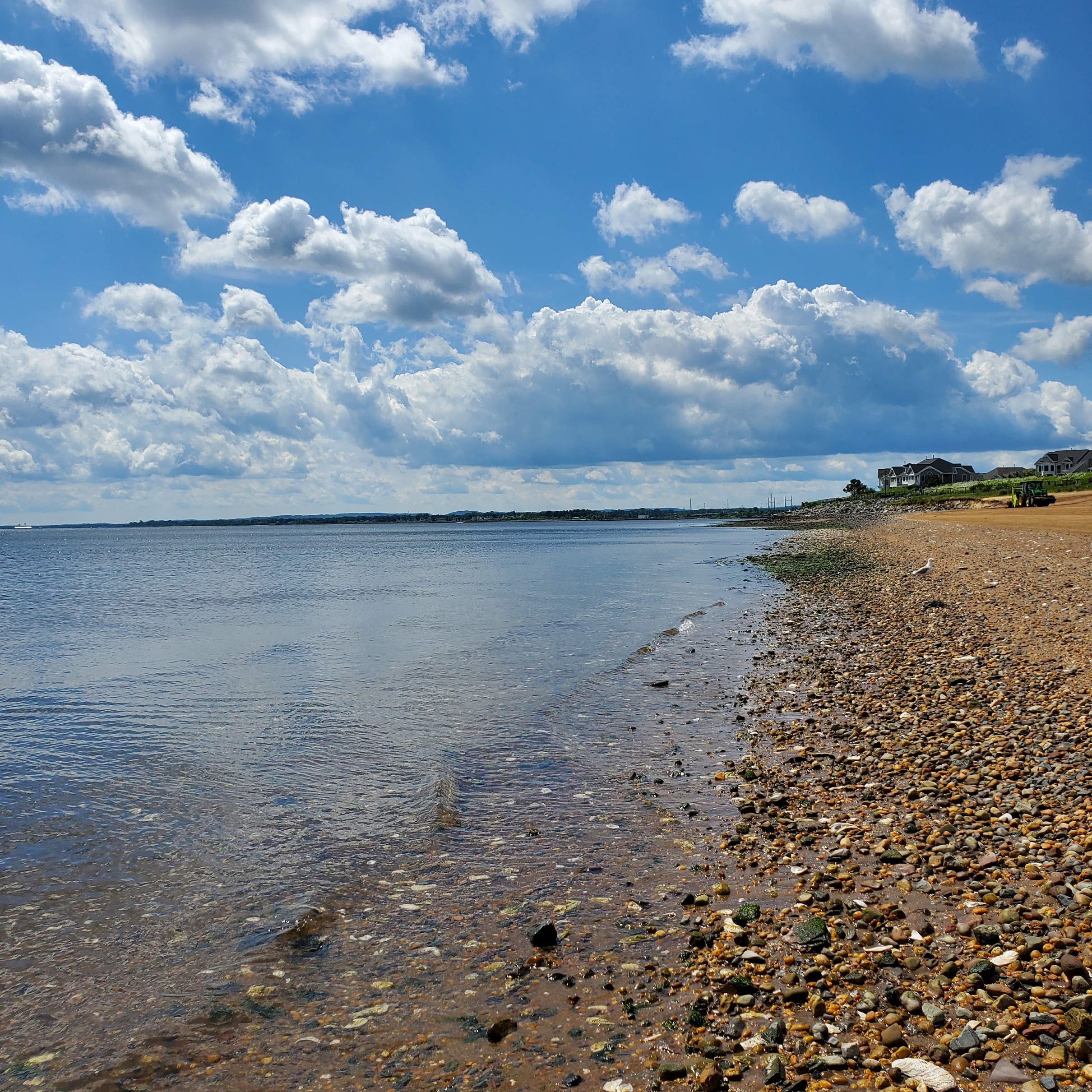
Our South Amboy site was especially beautiful yesterday – the water was CLEAR, reflecting big puffy clouds. Our South Amboy numbers were below the EPA threshold for Enterococcus, with low presence of fecal coliform as well.
South Amboy Waterfront 6.9.2022
Enterococci results are reported in Colony Forming Units or CFUs. Suitable levels for primary contact should not exceed 104 cfu/100mL. Pathogens/Enterococci levels are used as indicators of the possible presence of disease-causing bacteria in recreational waters. Such pathogens may pose health risks to people fishing and swimming in a water body. Sources of bacteria include Combined Sewer Overflows (CSOs), improperly functioning wastewater treatment plants, stormwater runoff, leaking septic systems, animal carcasses, and runoff from manure storage areas.
Huge thanks to our partners: Rutgers Cooperative Extension of Middlesex County and the New England Interstate Water Pollution Control Commission.
Moorestown Friend School Senior Emma Nei joins the LRWP as a 2022 Summer Intern. Here she shares her impressions of her first day “on the job” – conducting outreach for the LRWP at Rutgers Day.
This past weekend, I experienced my first day interning for the Lower Raritan Watershed Partnership and my first Rutgers Day, a day dedicated to showcasing the different programs, events, and culture of the Rutgers community. RU is my mother’s alma mater and she explained the excitement around this day and how thrilled she would be to run into past professors and classmates. We parked the car and made our way to find the LRWP table. I was struck by the smells coming from food trucks and the sounds of tents and tables being set up. Thankfully, it was beautiful outside. With the sun shining through the trees and a nice breeze on my neck, I knew I would enjoy the day. Surrounding the water body known by students as Passion Puddle, there were dozens and dozens of displays for many different organizations. You could measure how high you could jump at the Kinesiology Department’s table or play trivia games with the State Climatologist. After a few minutes of walking, a large rain barrel and a colorful sign captured my attention. I had arrived at my destination.
Jocelyn and Piash, two other interns for the LRWP, quickly showed me the ropes. I had already done some background research on the watershed but they taught me the best ways to catch peoples’ attention as they walked by, answer their questions and introduce some of the programs LRWP offers. Soon I was explaining the basics of the water monitoring program, how samples are taken every week from six different locations along the Raritan and where to find the results posted online. I answered questions as best I could but when someone asked about green infrastructure in their town, Jocelyn and Piash were both there to swoop in and help.
I loved my environmental science classes this past year. I knew I was interested in science and research from the projects I had done throughout high school. Wrapping up my senior year through internship is an exciting way to learn something new and gain some work experience before heading off to college. Classes end in April at my high school and students are required to intern for an organization of their choosing during the month of May. After going through a list of environmental non-profits, my mother suggested looking at the LRWP. Their website and newsletters really conveyed the mission, purpose and passion of the organization and I wanted to experience it. My interest in the health of local waterways increased as I saw the wide range of programs offered.
As the hours of Rutgers Day passed, all sorts of people came up to our display to ask about specific projects. Engineering students wondered how bad the pollution was in various waterways. An outdoorsy couple approached, wondering about the best times to go kayaking or hiking around the Raritan River. Children wandered up to look at the plastic bugs on the table, their curiosity piqued. It became obvious to me that the health of local waterways impacts the whole community; no matter how old you are or what your background is, you are affected in some way. So many different people stopped at the table and shared their concerns about the health of their waterways. We were able to provide ways for them to learn more, to help monitor them and to actually help clean them. A mother came to the table with her two boys who were fascinated by the critters on the table. She was curious about how safe the waterways were because her son liked to collect rocks by the river. She also wanted to learn if she and her family could come out and volunteer. I realized that LRWP wasn’t just a means to collect data and inform people about issues but also a way to bring the local community together through service. As my day wrapped up, I said goodbye to some new friends and felt excited to start my internship.
Imagine a colorful fleet of canoes and kayaks gathered at the confluence of the north and south branch in anticipation of the start of a dash down the Raritan River to the sea. Described as a sojourn, dash, race and tour to accommodate all levels of experience, the finish lines for each class can be a different take out along the way. Classes for racers, timed for placement and simply celebration upon reaching any chosen finish line for the touring dashers. Distance or time become the personal feedback for participants who may wish to improve their last year’s performance. In that way the ‘race’ has the elements of developing into a tradition where dad’s and daughters, moms and sons, look forward to next year and maybe in anticipation, focus on improving their health and physical conditioning.
The paddler’s intimacy with the Raritan brings with it a deeper appreciation of the river, which has existed as more of a concept to most people who may only glimpse it at a distance, while passing over a bridge on the way to work. With intimacy comes consideration and concern about all things impacting the river and its watershed.
The possibilities to grow a network of support for the treasure that is the Raritan River, are limited only by imagination. Photographs and art work inspired by the river’s appearance through the seasons could be celebrated by riverside towns, restaurants, schools and galleries to be dispersed far and wide. Like seeds in the wind, the beauty and appreciation of the Raritan may be an inspiration to awaken distant communities to the riverine treasures in their backyard.
One example of a successful effort to market a once polluted river, is the Kenduskeag Stream Canoe Race, held each April, in Maine. At one time salmon and eels returned from the sea via the Penobscot River to the Kenduskeag stream. By the time Thoreau walked he shores of the Kenduskeag in the mid 19th century, tanneries and flour mills blocked and poisoned the stream and continued well into the 1960s. A group of local canoeists came up with the idea for a canoe race to showcase the Kenduskeag and bring attention to its health. Eventually the race expanded to be televised and enjoyed by hundreds of viewers and attendees. The salmon run is making a comeback and even Sports Illustrated found room on its cover to celebrate the longest early season canoe race in New England. I participated in this race for eighteen years and carried the seeds of inspiration back to the Raritan. It is no small coincidence that Henry David Thoreau left indelible footprints along the Raritan River and the Kenduskeag for future generations to follow.
The crowd of streamside supporters bundled dry and warm, cheer on canoeists who await the countdown for the start of the Kenduskeag Stream Race. The countdown to the start of the race, 5. 4. 3. 2. 1.gets the adrenaline flowing. This is a scenario that may someday be played out at the confluence of the Raritan River.
Author Joe Mish has been running wild in New Jersey since childhood when he found ways to escape his mother’s watchful eyes. He continues to trek the swamps, rivers and thickets seeking to share, with the residents and visitors, all of the state’s natural beauty hidden within full view. To read more of his writing and view more of his gorgeous photographs visit Winter Bear Rising, his wordpress blog. Joe’s series “Nature on the Raritan, Hidden in Plain View” runs monthly as part of the LRWP “Voices of the Watershed” series. Writing and photos used with permission from the author. Contact jjmish57@msn.com.
Throughout 2021, I volunteered with the LRWP to build a wooden boat—a long, narrow rowing shell–destined for use on the Raritan River. During the pandemic, this boat building project was like a good dream. While I spent weekdays working remotely, Saturdays with the boat project meant the smell of cedar, the roar of the power planer, the feeling of smoothly sanded wood, and being with other people. One year later, I decided to live that dream by pursuing carpentry and wooden boat building through a program called The Carpenter’s Boat Shop, located in mid-coast Maine.
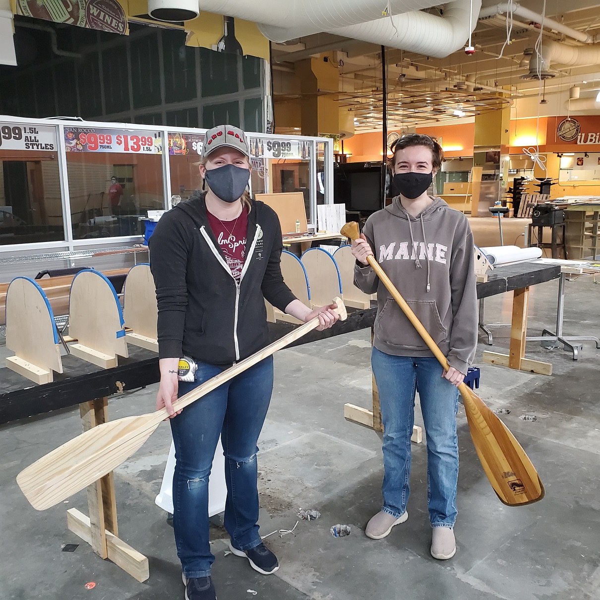
Essay author Sarah Tomasello (right) and Amber Hennes volunteered as paddle build leads for the LRWP’s 2021 boat build project
Like many volunteers working on the rowing shell with the LRWP, I began with minimal experience. Our workshop was a hands-on classroom where other volunteers generously shared their skills. With this support I quickly gained more experience and confidence. Along the way I discovered that I liked nothing more than being in a workshop environment, making things with wood and tools, teaming with others to solve problems, and getting caked in sawdust.
This past February, I drove up to Maine and entered the 4-month long Carpenter’s Boat Shop program, where I am continuing to learn how to build small wooden boats. This program resembles the LRWP boat build project in that it is centered around building a community and sharing skills. At the Boat Shop, I live and work alongside a group of eight other apprentices, sharing chores, cooking meals, going for hikes along the coast, and building a type of row boat called the Monhegan skiff.
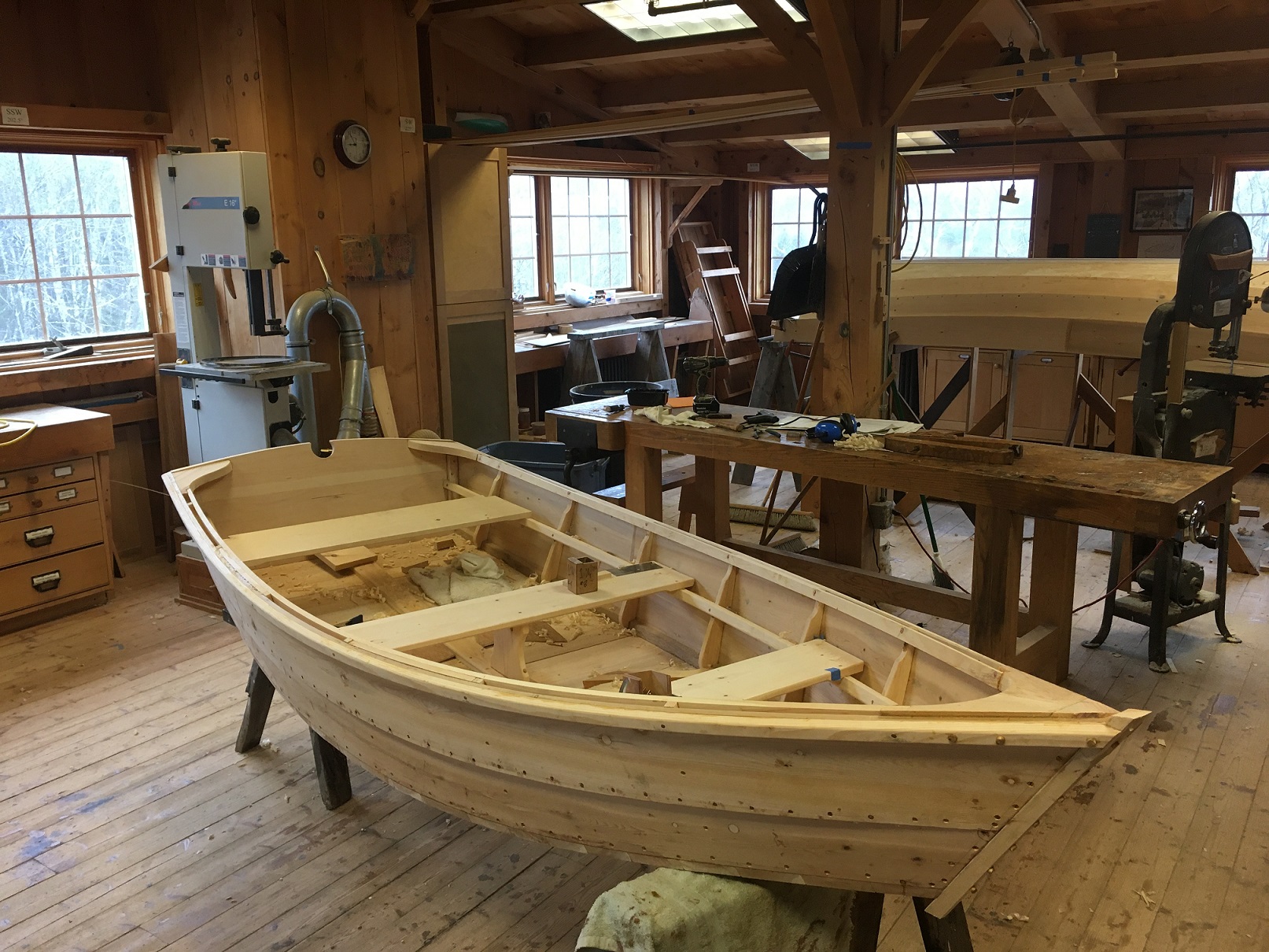
Working on a Monhegan skiff at the Carpenter’s Boat Shop in Maine
The Monhegan skiff is an historic vessel in this region that is still used by the residents of nearby Monhegan Island. Once used primarily by fishermen, the Monhegan skiff was designed to safely navigate the rolling ocean waters around the island and transport fishermen between the shore and their workboats. The skiffs are still purchased for this purpose. The neighbors who frequently visit the Boat Shop campus may have ties to Monhegan Island or have worked as boatbuilders in the region. It is not uncommon to see old wooden boats—restoration projects in progress—sitting in front yards. It is inspiring to be in a place where there is a palpable sense of history and connection with the natural environment. The craft of building small wooden boats weaves these things together.
Being part of this community in Maine makes me excited about what wooden boats can do for the Raritan region. Building the rowing shell with the LRWP helped me see the history and beauty of the Raritan River, Raritan Bay, and nearby waterways. Bringing a community together to build small, well-crafted boats builds a culture of connection with local waterways, local history, and between neighbors, hopefully leading to increased stewardship and recreational access to the Raritan.
Since Summer 2019 the Lower Raritan Watershed Partnership and Rutgers Cooperative Extension of Middlesex County have conducted pathogens monitoring for Fecal Coliform and Enterococcus at six non-swimming public beach access sites along the Lower Raritan during the warmer months.
In this video, filmed as part of a public outreach session on 3.24.2022, we present a summary of data and findings for 2019-2021 monitoring, including analysis results of genetic source. We also share information about our monitoring plans for Summer 2022, including our partnership with the EPA.
The New Jersey State Department of Environmental Protection (NJDEP) is currently conducting the 2022 Clean Watersheds Needs Survey (or CWNS). The LRWP encourages all Lower Raritan communities to participate so as to collect information about wastewater infrastructure, stormwater – grey and green infrastructure, and non-point source pollution control projects, including the needs for decentralized wastewater (or septic) systems.
The U.S. Environmental Protection Agency (USEPA), in partnership with the State of New Jersey and other states, surveys communities every four years to identify any water quality or public health-based capital needs (up to 20 years) and costs in your community. The results are published in a Report to Congress, and it is used by Congress and state legislatures in their budgeting efforts.
The CWNS data are also used to help measure environmental progress, contribute to academic research, provide information to the public, and help local and state governments implement water quality programs. This data can influence the allocation of SRF funds and future special federal grants or funding programs. The CWNS is your best opportunity to let our decision-makers better understand the financial challenges you face in implementing your wastewater, stormwater management, and NPS pollution control programs.
To participate in the survey, first identify any water quality or public health-based capital needs (up to 20 years) and costs in your community that were not funded by January 1, 2022. Then, submit these community needs by completing the online survey form and uploading any supporting documentation describing your community’s new needs and costs.
CWNS online webpage registration and login instructions:
2) For your initial usage, please click on the “Click here to Register” button.
3) After your registration is complete, enter your e-mail and click “Log-In.”
4) A confirmation e-mail will be sent to you with a link that takes you to the needs survey page showing thelist of all your surveys.
5) To create a new survey, click the “Start New Survey” button.
6) You must submit any open survey before you may create another.
Please submit the survey with your community needs and supporting documents by May 31, 2022.
If you have any questions about the CWNS or need assistance in filling out the form, NJDEP will provide technical support. If you have identified your needs but lack the supporting cost documentation, NJDEP staff can provide alternative means of documenting these costs or assist you by using a cost estimation tool. Please contact Ketan Patel or Kyle Carlson at 609-292-3114 or e-mail at NJCWNS22@dep.nj.gov.
On March 21 we welcome the first day of Spring in the northern hemisphere. Most of us learn in elementary school that as the Earth rotates on its axis, the tilt of rotation brings the northern and southern poles either closer to or farther from the sun. In the farther position each hemisphere experiences less daylight, and the days are cooler. In the closer position – hello Spring! hello Summer! – more concentrated sunlight results in warmer days and longer periods of daylight.
Our relationship to the sun also affects the night sky, and the visible constellations are seasonal and change throughout the year. If you make a habit of looking at the sky every morning just before sunrise or every night right after sunset, you will start to notice how a few new stars emerge in the east each day. Since the sun and stars move at different rates, the change you observe is what is revealed with a gradual tilt of the earth’s axis at approximately one degree per day.
One thing that doesn’t change while the earth moves on it’s axis is the latitude, or north–south position, of specific points or locations on the Earth’s surface. New Jersey’s Liberty Science Center explains: “The key factor determining which stars we can see on a certain night is our latitude. Latitude is how far we are north or south of the equator.”
Our Raritan Watershed is 40 degrees north of the equator. Other 40th latitude cities include Menorca, Sardinia, Beijing, Humboldt County, Boulder and, closer to home, Philadelphia. Per the 1894 Kansas-Nebraska Act, the 40th parallel north also forms the boundary between the states of Kansas and Nebraska. Anyone at the 40th parallel looking up at the night sky at the same time of night will see the same stars that we do in our Lower Raritan.
As fascinating as looking at the night sky is as a way to track seasonal change, of course there are other ways to use our position in space to perceive the passage of time. Instead of looking up at the stars at night we can observe the change in shadows on our landscape. As the Earth rotates towards the sun, the sun gets closer to the zenith, or its directly overhead position. This affects the cast of shadows on the landscape around us.
Use Spring Equinox to start investigating the interplay of sun and shadow on the landscape.
Photo taken in Rutgers EcoPreserve at approximately 2pm February 20, 2022.
The photographer Henri Cartier-Bresson wrote “To take photographs means… putting one’s head, one’s eye and one’s heart on the same axis.”
The sun rising during the spring and summer months in our sky means that heat and light reach our surface at a steeper angle. The result: noon on a summer day (the sun’s highest position) casts almost no shadows. Similarly, in the winter, the angle of the sun drops lower casting less concentrated heat and longer shadows. Just as the sun’s proximity to earth directly affects the Earth’s surface temperature, the angle of the sun also dictates the length of shadows. Areas closer to the equator experience much less of this phenomena because their relationship to the sun’s position is much more consistent year round.
Starting Monday, March 21 – the first day of Spring – we will start a three month daily “meditation” on the intersection of shadows, space and time. Will you join us? All you need is a willingness to commit to visiting a site in your neighborhood landscape every day at the same time, and an interest in tracking a shadow in your neighborhood to mark the climb of the sun. We welcome you to share your observations!
Here’s how: Choose an open area with plenty of direct sunlight, then pick an object that casts a distinct shadow. At the same time each day between the March 21 Spring Equinox and the June 21 Summer Solstice visit the object and measure the length of its shadow. Over time you should see the shadow shrink slowly. After the first month, make an estimate of how long you think the shadow will be at the end of your observations. And consider this: the days get longer, our shadows get shorter, but the sun doesn’t change size or temperature during the seasons, it is only our position that changes.
On February 24, 2022 the Lower Raritan Watershed Partnership, Princeton Hydro and Middlesex County Office of Planning hosted a Virtual Outreach Session to share concept plan development for the restoration of a 165-acre coastal eco-park along the South River in New Jersey.
During this webinar project partners discuss ecosystem restoration; contextualize the site and its historic and current conditions; provide drone images of the site; and discuss proposed public access opportunities, recreational priorities, ecological enhancement (including identifying optimal nest platform locations for Osprey, Bald Eagles, and Peregrine Falcons), and more.
This project is supported through a $249,639 in National Fish and Wildlife Foundation grant to:
“Conduct an ecosystem restoration site assessment and design for 165 acres of tidal marshes and transitional forest in New Jersey’s Raritan River Watershed. Project will result in an engineering plan with a permit-ready design to reduce coastal inundation and erosion along about 2.5 miles of shoreline for neighboring flood-prone communities and enhance breeding and foraging habitat for 10 state-listed threatened and endangered avian species.”
During one, six thousand year moment, in the eons of glacial expansion and retreat, the Queen of Rivers was born. So described by an early nineteenth century writer, inspired by the bucolic Raritan River. The beauty of the river’s pastural floodplain dotted with colorful native flowers and grasses, stood in contrast to the intermittent high, red shale cliffs. Spring floods scrubbed the red shale soil from its banks to turn the raging river into a semi solid crimson torrent. The contrast in color is dramatic where gravel lined upland streams tumble into the main river current.
From sweet water freshet to the brackish tide water of its bay, the Raritan’s unimpeded flow expressed its seasonal moods in uninhibited water-colored brush strokes across the landscape, as if it were a living canvas.
So, the Raritan River proper, as it is defined today, deserves the recognition of a natural wonder, a reference point in geological history, worthy of attention in a state marked by an ever changing manmade landscape.
The Raritan’s headwaters arise from two major sources in the north, the South Branch from Budd Lake, and the North Branch from a swamp in Chester. The confluence of these two rivers join (in Branchburg) to form the Raritan River.
Facing upstream at the confluence, the river on the left enters from the south and is so named the South Branch, despite its origin in the north. The river on the right comes in from the north and is aptly named the North Branch.
If ever a natural wonder needed to be celebrated it would be the Raritan River. Toward that end I always imagined a rough stone marker of an age befitting the river queen’s origin be placed at the confluence, “the meeting place of waters”, Tuck-ramma-hacking”. Informal and primitive to match the uninhibited behavior of this ancient watercourse, a perfect partner to mark the celebrated river’s place of birth: a monument that will be submerged during spring floods and bear the scars of ice flows.
I imagine a bronze plaque bearing the name of the river and its birthdate set among petroglyphs of animal tracks and wild flowers carved into the stone by local artists to represent the community the river serves.
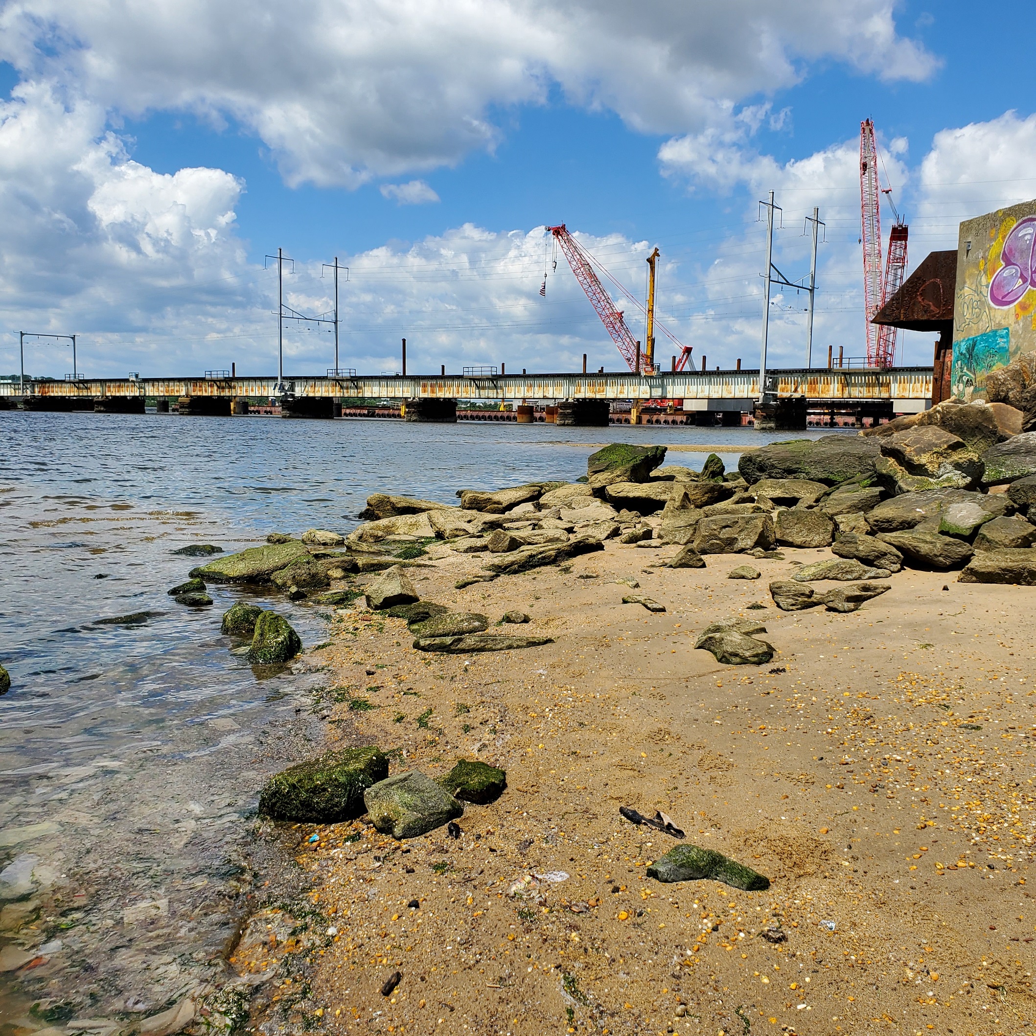
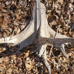
The spot for eventual placement of a “birthplace of the Raritan” marker
Bringing a dream to reality often turns to fantasy. At least now an attempt is being made to explore the possibility of placing such a stone at the apex of the North and South Branch Rivers. Through a network of well-placed friends, we have approached the state with this request to determine feasibility. A labyrinth of permits and permissions remains to be navigated if given conditional approval. At the very least, the ship has left the dock and we will soon learn if it is seaworthy.
A stone, not yet chosen, has been promised and placement will be included. The river deserves to have a name and birthstone. Erroneously, the North Branch has official signage that declares it to be the Raritan River. If nothing else, it would be a worthy accomplishment to establish the correct identity.
“Like a pine tree linin’ the windin’ road, I’ve got a name, I’ve got a name…..” go the lyrics to a song. What is in a name is respect. It is our nature to treat anonymity differently than familiarity. Walk through a field, not knowing one plant from another, go from point A to point B and we naturally take a straight-line course. Eyes planted on the far side, anything in the way gets stepped upon. Guarantee that if a plant is identified to the trekker, whether it be fleabane or little bluestem, the path will be adjusted to avoid stepping on the now identified plant. So it is with names that emerge from anonymity, they project some kindred link that brings conscious thought to bear. A good reason to identify the Queen of Rivers and engender some new found respect for a natural wonder that will be here after we and our kin are long gone.
Author Joe Mish has been running wild in New Jersey since childhood when he found ways to escape his mother’s watchful eyes. He continues to trek the swamps, rivers and thickets seeking to share, with the residents and visitors, all of the state’s natural beauty hidden within full view. To read more of his writing and view more of his gorgeous photographs visit Winter Bear Rising, his wordpress blog. Joe’s series “Nature on the Raritan, Hidden in Plain View” runs monthly as part of the LRWP “Voices of the Watershed” series. Writing and photos used with permission from the author. Contact jjmish57@msn.com.