**Please note date change**
For our March 12 general meeting, in recognition of the 2018 World Water Day theme of “Nature for Water,” we have asked Rutgers Professor JeanMarie Hartman to present on “The Role of Forests as Green Infrastructure.” As part of this presentation, Professor Hartman will provide an overview of a proposal to reforest vacant lots in Perth Amboy as a way to manage combined sewer overflow events.
The design suggestions will be compared to current best management standards and practices. Discussion will also elucidate several points regarding the relationships between human and natural systems such as resource conservation, habitat restoration and creation, and urban ecology.
The meeting will be held from 10-noon in the Middlesex County Planning Offices at 75 Bayard Street, New Brunswick, NJ – 5th floor mid-size conference room.
Parking is validated for those parking on floors 5 and higher in the RWJ Wellness Parking Deck located at 95 Paterson Street, New Brunswick, NJ 08901. Be sure to bring your ticket to the meeting for validation.
For more information contact Heather: hfenyk AT lowerraritanwatershed DOT org
Article and maps by Sophie Benaroya, Rutgers University Sophomore
This summer I worked in Dr. JeanMarie Hartman’s Lab at Rutgers University researching factors that affect infiltration rates. More specifically I looked into how soil health indicators compare with infiltration rates in New Jersey’s Lower Raritan Watershed.
Soil health and infiltration rates are important because of their wide-reaching effects. Soil health affects groundwater, surface runoff (and hence flooding), and vegetative productivity. Unhealthy soil can lead to contaminated groundwater and waterways, a decrease in arable land, a decrease in forests and an increase in flooding risk. There are many factors that affect soil health, infiltration being one of them. Soil can be impacted by organic matter content (animal and plant matter in various stages of decomposition), soil fragments (rock fragments larger than a grain of sand) and amount of impervious surface – like roads, pavements and parking lots, and land use. Previous research has shown that urbanization has a major impact on soil health, and due the fact that the Lower Raritan Watershed is mostly urban land I felt it would be interesting to see how urbanization may have affected the soil.
To research the topic, data was downloaded from the Web Soil Survey, the official source of soil data for the United States. I analyzed these data using ArcGIS, a mapping software, and Microsoft Excel. Data on various chemical, physical and water properties on soil in the Lower Raritan Watershed was downloaded and compared to infiltration rates. As there is no data on infiltration as is; saturated hydraulic conductivity and hydrological soil groups were used as surrogates (this decision was based on the recommendations of professionals in the field). The factors that were researched were organic matter content, percentage of fragments in soil, bulk density (how compact the soil is), surface runoff class (the amount of water flow on land and is not absorbed into the soil), impervious surface cover, and land use.
First, I compared saturated hydraulic conductivity and land use. This comparison, as well as the tabular data, showed that urban areas have lower saturated hydraulic conductivity levels than Forest, Wetland and Agricultural areas.
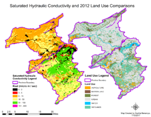
Figure 1: Saturated Hydraulic Conductivity and Land Use Comparisons
Then I compared hydrological soil groups with soil fragments percentages in the soils (Figure 2, below). Hydrological Soil Groups are groups that soil is placed in based on its surface runoff class, saturated hydraulic conductivity, and infiltrometer data. There are five classes as follows: A – High infiltration, B – Moderate infiltration, C – Slow infiltration, D – Very slow infiltration, and A/D, B/D, C/D – Dual soil groups (first letter represents drained areas, second letter represents un-drained areas.) It is evident from the map that soils with a percentage of fragments of 28% and above generally fall under soil group “D”, further insight into tabular data showed that 58.39% of soil in group D have over 28% fragments. Soil groups A and B had the majority of their soils have 6% or less fragments.
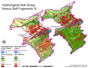
Figure 2: Hydrological Soil Groups versus Soil Fragments %
I then looked at saturated hydraulic conductivity versus surface runoff class comparisons. In this analysis (see Figure 3 below) I compared the relationship between saturated hydraulic conductivity and surface runoff class. Saturated hydraulic conductivity is very high (51-150 micro meters/sec) in soils with negligible, very low and low surface runoff. The medium level of hydraulic saturated conductivity is generally lower in the medium, high and very high classes.
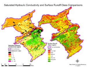
Figure 3: Saturated Hydraulic Conductivity versus Surface Runoff Class Comparisons
Then I looked at saturated hydraulic conductivity and impervious surface percentage comparisons.
Figure 4 below compares the relationship between saturated hydraulic conductivity and impervious surface percentage. As impervious surface increases, high rates of conductivity (6-15 and 51-150 micro meters/sec) decrease in frequency.
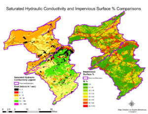
Figure 4: Saturated Hydraulic Conductivity and Impervious Surface % Comparisons
Finally I looked at the breakdown of impervious surface percentage in natural, hydric and urban soils. Figure 5 below shows that over 98% of both hydric and natural soils have 0-5% impervious surface, compared with only 13.51% of urban soils.
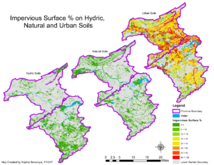
Figure 5: Impervious Surface % on Hydric, Natural and Urban Soils
Through my research I found that unfavorable levels of indicators were linked to lower levels of infiltration. The most interesting finding was the effect of land use on soil health. Urban land had lower infiltration rates than forests, wetlands and agricultural areas. In addition, urban lands had low levels of organic matter, high levels of soil fragments and, high levels of impervious surface. The increase in impervious surface is linked to urbanization. Natural and hydric soils in the Lower Raritan Watershed had less than 5% of their soils exhibit impervious surface cover of 5% or more, compared to almost 75% of urban soils. However, not all urban land uses had the same levels. Athletic fields, recreational land and cemeteries had higher levels of infiltration than military or industrial land; possible because they have more vegetation.
Another important finding had to do with forests. Forests and wetlands have high infiltration rates, however in the Piedmont province there is more fragmentation and as such those forests and wetlands typically have lower levels of infiltration than forests and wetlands in the Coastal Plains province. This means that an increase in the fragmentation of forests potentially due to urbanization would be detrimental to soil health, as forests in the Piedmont have an average saturated hydraulic conductivity rate of 18.52, whilst forests in the Coastal Plains province have an average of 53.21.
The main take-aways from my research is that protection of forested areas could help prevent soils from worsening, and an increase in planting in and around current forest areas could help improve the soil of current patches. An increase in green infrastructure could also be beneficial in improving urban soils by increasing the vegetative cover, organic matter and reducing surface runoff.
Article by Dorothy Lee, Rutgers University Sophomore and LRWP Summer Soils Intern
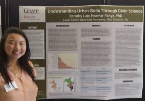
LRWP intern Dorothy Lee, presenting at Rutgers (photo by Heather Fenyk)
This summer I had the opportunity to intern for the LRWP doing soils and civic science research. My job was to conduct initial research into how the LRWP could develop a civic science soil monitoring program to better understand soils functions for an urban watershed level. Urban areas can benefit from soil mapping exercises because urban soils are a concern for food supply, drinking water, stormwater control as well as aesthetics and recreation. Particular issues of urban soils are related to impervious surfaces, erosion, land filling and land leveling, surface removal, contamination, sedimentation and severe compaction. The benefits of working with civic scientists to aid in research means that data can be collected efficiently and in a timely manner while simultaneously connecting the community to their environment.
The LRWP’s specific interests as they relate to soil include soil enrichment for stormwater retention and for bionutrient food availability. After researching these issues, I worked with LRWP President Heather Fenyk and Professor Stephanie Murphy, Director of the Rutgers Soil Testing Lab, to identify ways that the LRWP could begin to engage the Lower Raritan Watershed community in soils research. A few of the actions we thought could orient conversation for future soil-health-oriented civic science studies include: having area civic scientists work to identify “new” bacterial phyla, linking soil health improvement goals to impervious cover remediation actions planned at the municipal level, and evaluating rain gardens as a management strategy to increase soil C, optimize soil N cycling processes, and reduce leaching and gaseous emission losses of nitrogen.
The LRWP is also beginning to develop a plan to communicate the benefits of composting for soil enrichment. This relates directly to my work at Rutgers with a new club, RU Compost. Compost is an efficient way to reduce our food waste, cycle nutrients back into our soils, and create more awareness and education opportunities to the public. At Rutgers our club is working to implement composting in our dining halls and students centers, and we are also working on building a compost demonstration for the Spring semester in the Lower Raritan Watershed. Look for us in the spring!
Check out these pics from June 16, 2016 water quality monitoring in the Englishtown area of the LRW. Waters were bright orange in color with very low pH (3.8):
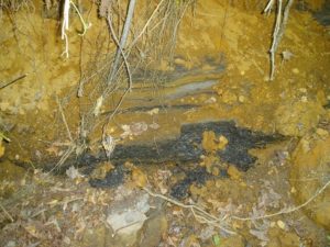
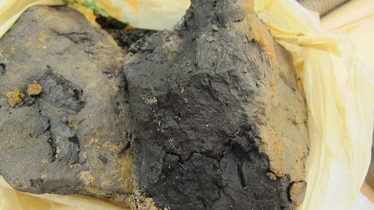
Upstream was an eroding bank with charcoaled, black wood:

What’s going on here? This is an acid-producing deposit from the Englishtown Geologic Formation. According to Stephanie Murphy, Director of Rutgers Soil Testing lab: “When deposits are buried (not exposed) the mineral is iron sulfide and pH is not “unusual”. It can have black color. When exposed, the extreme acidity results from certain microbes oxidizing the sulfide to sulfate with H+ produced. Same process with acid coal-mining spoils. Acidity makes iron soluble, and when it re-deposits/precipitates, you get the orange hues.”
Also see the NJ Geological Survey’s Figure 1-1. NJ sedimentary units with potential to produce acid:
http://www.state.nj.us/dep/njgs/geodata/dgs09-2.htm