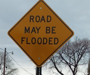
On Saturday November 7 join the LRWP and sculpture artist Tobiah Horton (Rubble R & D) during a “work day” as Toby installs a new sculpture #lookfortheriver: FRAME in New Brunswick’s Boyd Park Raritan River riverfront.
New Brunswick’s Boyd Park floodplain suffers repeat flood inundation, and serves as a protective “sponge” for other parts of New Brunswick. The #lookfortheriver: FRAME sculpture tells the story of infrastructure that is at-risk of flood inundation due to climate change and sea level rise. The sculpture is a living symbol of how removal of structures (in this case a house) from our floodplains allows for ecological restoration and regeneration, and fosters resilience.
Toby and the LRWP will explain how our FRAMES sculpture will function as a data gathering tool! Through repeat digital photography uploaded to social media, passersby participate in civic science data collection about sea level rise, land use change, and resilience. Data gathered will allow for prioritization of resilience and restoration planning.
With thanks to many wonderful partners and funders for their support on this project.
Grant funding has been provided by the Middlesex County Board of Chosen Freeholders Through a grant award from the Middlesex County Cultural and Arts Trust Fund.
Program funded by Middlesex County, a partner of the New Jersey State Council on the Arts.
And with special thanks to the New Jersey Council for the Humanities
On Saturday February 1 the Lower Raritan Watershed Partnership and the Rutgers Bloustein School Environmental Planning Studio will join the South River Green Team and the larger South River community for a conversation about resiliency in the context of riverine/coastal flooding and floodplain buyouts prompted by Superstorm Sandy in 2012. We will discuss research tasks the Environmental Planning Studio students will engage in during the course of the Spring 2020 semester, including work on a Sustainable Jersey “Water Story” action. Our discussion will be followed by a tour of the flood affected areas.
South River residents, and residents of the larger Lower Raritan Watershed, are welcome to join.
We will meet at the First Reformed Church, 40 Thomas St., Lower Level at 1 pm.
Parking is available in the lot that can be entered through the drive between 42 and 44 Thomas Street.
Agenda:
1 p.m. — Planning studio meets the Green Team
1:30 p.m. — Sustainable Jersey staff and partners join
2:30 p.m. — Tour of flood areas
Special attention will be given to South River’s Census Tract 69, home to a low socio-economic status immigrant community with a life expectancy well lower than the national average. Residents in Census Tract 69 have a four-year lower life expectancy than in neighboring tracts in South River, and the lowest in Middlesex County.
Throughout the course of the semester students will work to understand how coastal/riverine flooding, buyouts, open space, and water infrastructure (water supply, wastewater, stormwater) affects health outcomes. This will include analysis of development and neighborhood change patterns, living conditions, demographic shifts and what the long-term implications of this change may be for the region and other flood-inundated riverine and coastal areas.
Please contact the Lower Raritan Watershed Partnership for more information: #908.349.0281
We applaud the following Lower Raritan Watershed towns for securing Sustainable Jersey status in 2017!
East Brunswick – bronze
Edison – bronze
Monroe – bronze
New Brunswick – bronze
Plainsboro – bronze
South Plainfield – bronze
Woodbridge – silver
Hillsborough – silver
Somerville Borough – bronze
Warren Township – silver
Berkeley Heights Township – bronze
Summit City – silver
Extra kudos to New Brunswick, Perth Amboy and Woodbridge for securing 20 points in the “Climate Adaptation: Flooding Risk” action. This action is designed to help communities: 1) identify their vulnerability to flooding impacts (both coastal and inland) and 2) identify ways to improve their overall resiliency. This action focuses on the various causes of flooding that could impact a community, either now or in the future, including increased precipitation, increased frequency of heavy precipitation events, sea level rise and storm surge.
Climate change, population growth, urbanization and industrialization are all putting pressure on our communities and their access to safe and secure water supplies. Sustainable Jersey now awards points for Green Infrastructure Planning and Implementation Actions that can directly improve the water quality of our rivers and streams. Read more about these water-friendly actions on the Sustainable Jersey website.
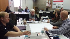
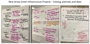
On November 17 the Lower Raritan Watershed Partnership joined with NOAA to co-host a day-long workshop: “Introducing Green Infrastructure for Coastal Resilience”. This workshop, designed for planners, engineers and municipal leaders not yet familiar with GI for coastal resilience, brought in more than 50 participants from the Lower Raritan Watershed and throughout New Jersey. It was a great event!
Workshop participants brainstorm ways to implement Green Infrastructure in their communities
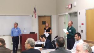
Many thanks to everyone who joined us for the workshop, with special thanks to our speakers: Lauren Long (NOAA), Toby Horton & Jeremiah Bergstrom (Rutgers Cooperative Extension), John Trucsinski (The Nature Conservancy), Linda Weber (Sustainable Jersey) and Carter Craft (Consulate General of the Netherlands).
Tobiah Horton (Rutgers Extension), Lauren Long (NOAA) and Carter Craft (Consulate General of the Netherlands) discuss local resilience responses
The workshop was timed to coincide with the 5th anniversary of Superstorm Sandy. We saw this anniversary as an opportune moment to reflect on successes in implementing GI thus far, as well as to frame challenges, solutions and opportunities for future GI interventions. Of course this work is just beginning. The LRWP, NOAA and Rutgers Marine Sciences are discussing how to continue the conversation in 2018. Stay tuned! For now, please see conference handouts, presentations, and additional resources below.