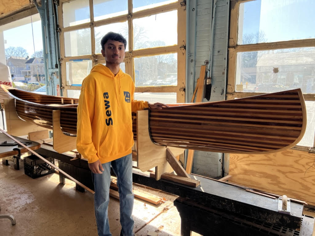
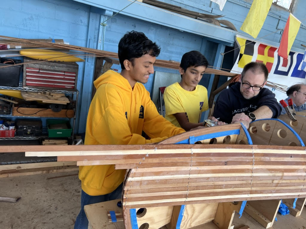
Aadharsh, 16, has always feared the water, making him a perhaps unlikely volunteer for the Lower Raritan Watershed Partnership boat build. This LRWP program aims to increase engagement with and understanding of the Raritan River. Moving water is something Aadharsh had avoided for years, yet this was his second year participating in building a canoe as a member of the Sewa International Central Jersey youth program, which he participates in as a junior at JP Stevens high school.
Aadharsh was drawn to the boat building project and the LRWP because of his love for the environment and dream of being an engineer. After building these boats, starting from the paper designs and research all the way through the construction process of fixing the panels in place and weaving the cane seats, Aadharsh now leads his engineering class at school as they use the same processes and skills he’s already learned in the boat house.
Even more than practical skills and insight into the engineering process, he’s gained deep sense of fulfillment, one he struggled to express as he laid his hands on the lacquered hull of last year’s canoe. “Watching the boat come to life” under his hands gives him the energy to come back each week. He gazed at the panels striping the side of the boat with a sense of awe, bordering on reverence. “You see that?,” he said. “We did that.”
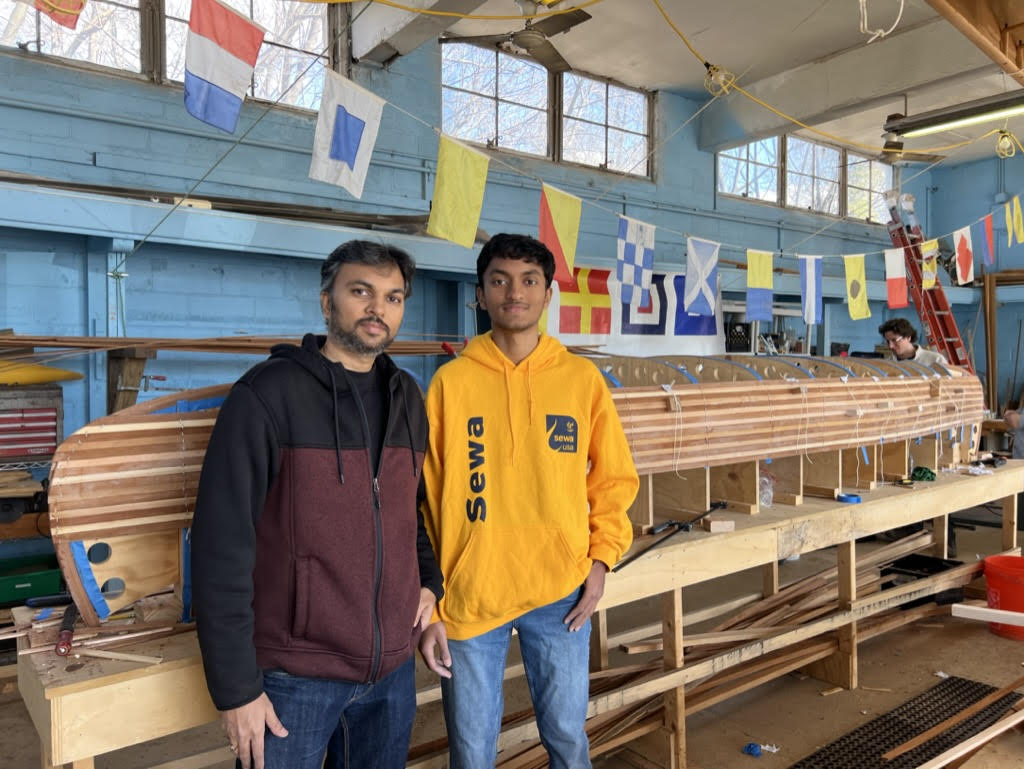
As Aadharsh’s father, Sakkaravarthy, watched his son work with other volunteers to attach the paneling, he expressed his great pride. He always tries to sign up to chaperone the teen volunteers when Aadharsh comes to the build. Not only does he get to watch his son explore his passion, when they return home and Aadharsh inevitably spends dinner enthusiastically talking about what he did at the boat build, Amid can smile along with understanding and pride.
Now, both father and son look forward to the boat launch, when the new canoe will hit the water for the first time this summer along with past years’ boats. Aadharsh can’t wait to paddle down the river that was once such a source of fear.
Join LRWP volunteers like Aadharsh and Sakkaravarthy at our boat-building session on Wednesdays from 6-8 and Saturdays 9-11. Pre-registration required. See you soon!
By LRWP Board President Heather Fenyk, Ph.D., AICP/PP
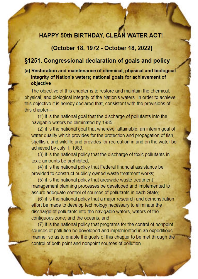
Today, October 18, 2022, marks the 50th anniversary of the Clean Water Act (CWA). To be sure, we owe a debt of gratitude to the shapers of the 1972 CWA for creating a law that significantly stemmed the flow of noxious point source pollutants into the nation’s waters. While we celebrate the successes of this seminal legislation, it is important to acknowledge the still unmet mandate of the CWA to bring about drinkable, fishable, swimmable waters. Water pollution remains a profound problem, with more than forty-seven thousand US waters still impaired. This includes every single stream, brook and river in the Lower Raritan Watershed. The major source of pollution into waters US and globally? Non-point source runoff from farm fields and the hardscape surfaces of our developed landscapes.
The LRWP believes we must chart a new path to meet drinkable, fishable, swimmable goals in the next 50 years:
In terms of strategy, centering the health of watersheds in environmental policymaking is key to realizing healthy waters.
This strategy must include integrated watershed management approaches that: 1) minimize impacts of land uses and development on waterways (good stormwater management is a start, however it does not go far enough as preventive practice); 2) require wastewater and stormwater be managed as assets; and 3) center the hydrologic cycle and aquatic systems in maintaining and restoring habitat connectivity.
On October 22 the LRWP will host a clean-up of the South River floodplain to recognize the 10th anniversary of SuperStorm Sandy. Reflecting on the impact of this storm we recall the catastrophic failure of Middlesex County Utilities Authority’s centralized sewage treatment facility. Sandy-related failure of the MCUA facility resulted in direct point source discharge of hundreds of millions of raw, untreated sewage into our waters. Observing how MCUA continues to discharge treated sanitary sewage into the Raritan River gives us pause. A holistic watershed management approach views wastewater as an asset, with water reclamation and reuse closing the loop between water supply and wastewater disposal. Setting an agenda for clean water for the next 50 years we must prioritize these better ways to clean up our waterways while meeting other sustainability goals.
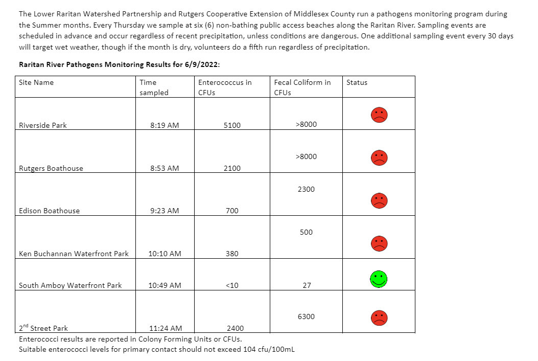
With 0.83 inches of rain on Thursday morning June 9, you can probably guess the water quality vibes! High Enterococcus levels at almost all our pathogens monitoring sites this week (read about the exception below) means Raritan River lovers should be wary of engaging in waterfront activities this weekend.
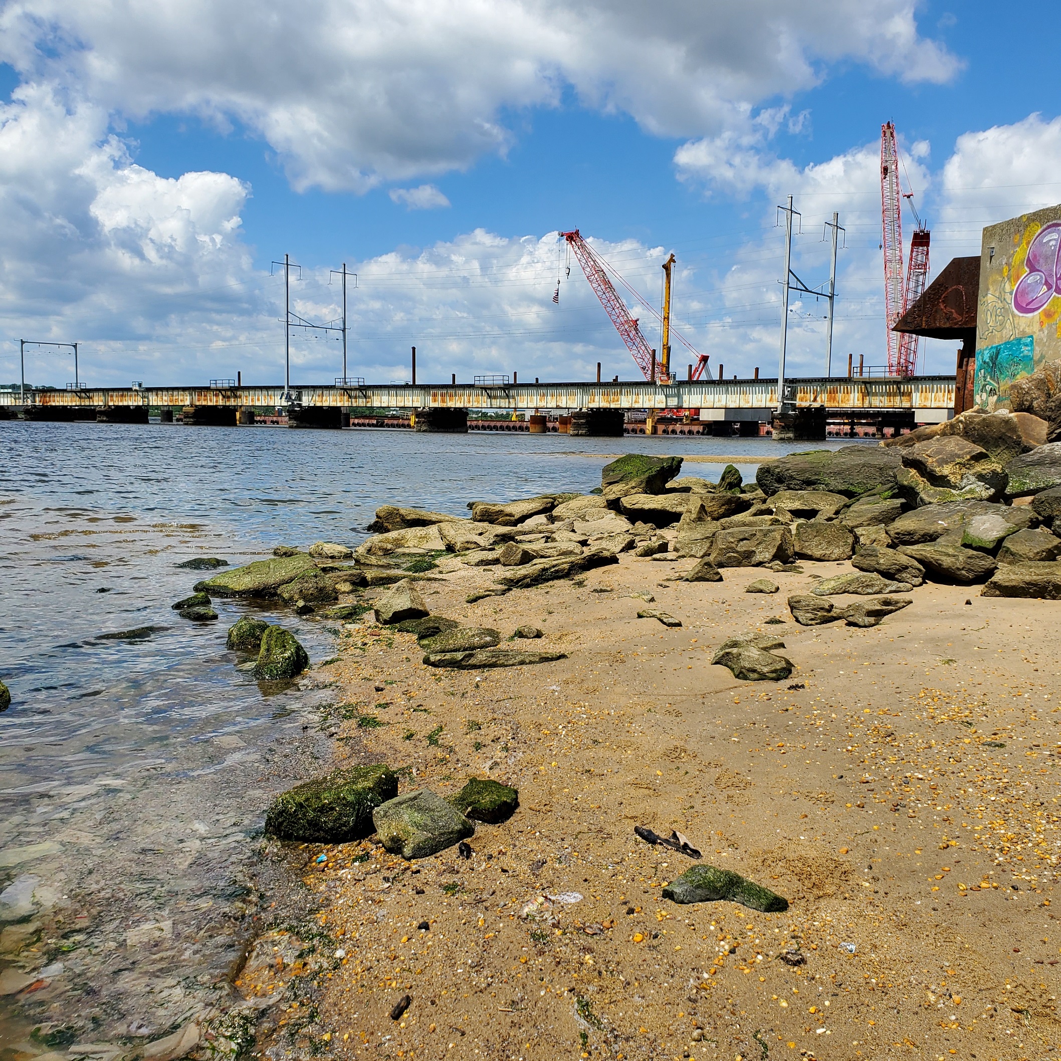
Our Perth Amboy site was especially gross. Water Quality monitoring after heavy rains near combined sewer overflows (CSOs) is never pleasant. Look closely at the waterline in the photo below. What you see is several inches of pulverized toilet paper, disposable wipes, and poo defining the water’s edge at our 2nd Street Park Perth Amboy site. There was active discharge of sanitary sewage from the CSO, the pipe in the middle right of the image. Any guesses as to the dominant odors?
Perth Amboy Waterfront 6.9.2022
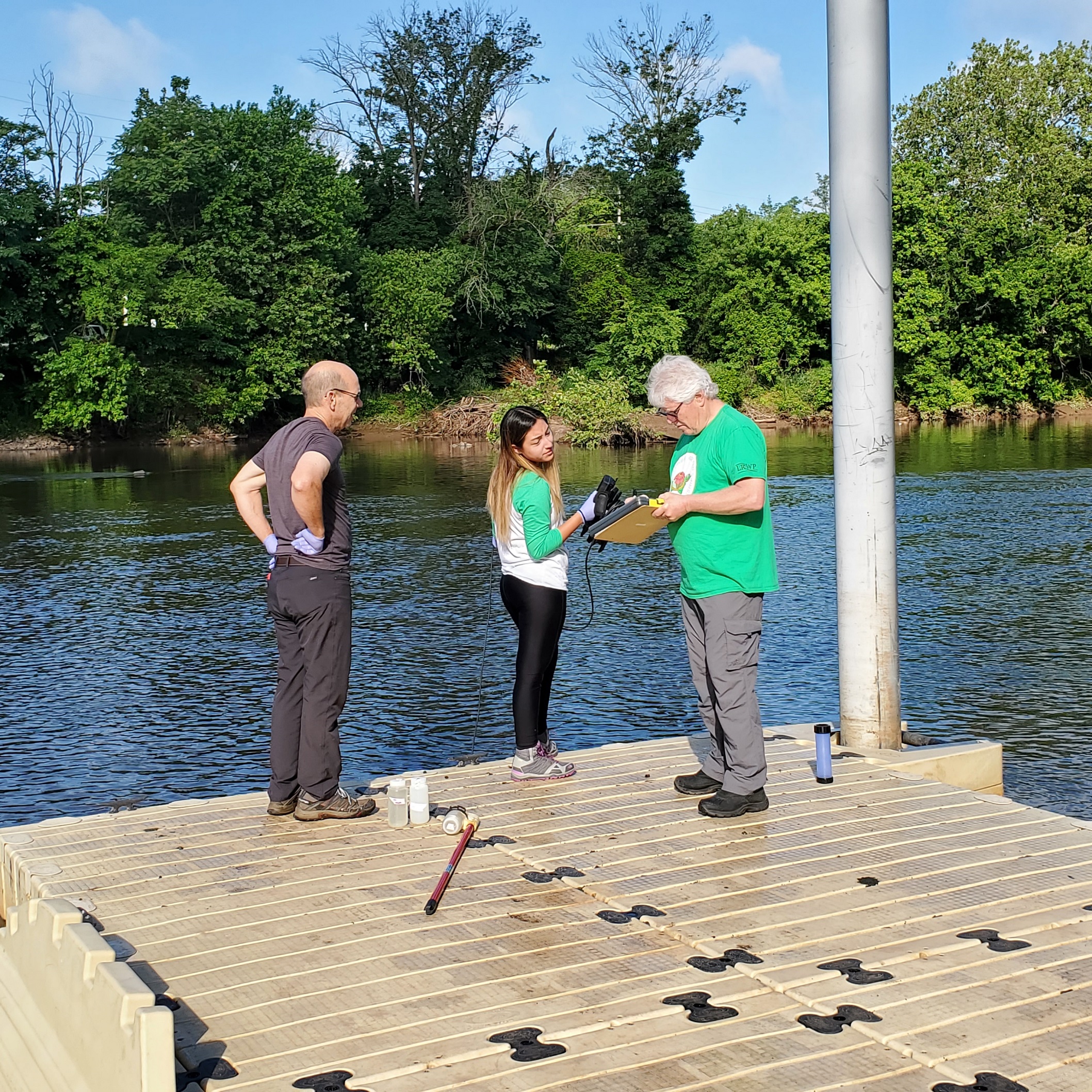
Despite the yuck factor, it was a GORGEOUS day to get out for some sampling. Huge thanks to our crackerjack team including the LRWP’s Community Outreach Project Manager Jocelyn Palomino, and our volunteer monitors Andrew and Frank pictured below.
The LRWP’s monitoring team at Piscataway’s Riverside Park
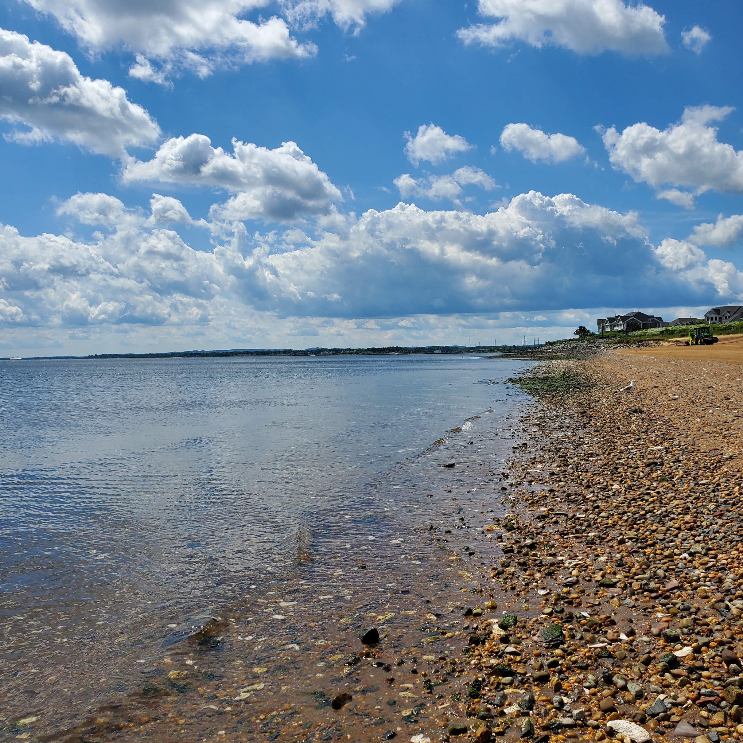
Our South Amboy site was especially beautiful yesterday – the water was CLEAR, reflecting big puffy clouds. Our South Amboy numbers were below the EPA threshold for Enterococcus, with low presence of fecal coliform as well.
South Amboy Waterfront 6.9.2022
Enterococci results are reported in Colony Forming Units or CFUs. Suitable levels for primary contact should not exceed 104 cfu/100mL. Pathogens/Enterococci levels are used as indicators of the possible presence of disease-causing bacteria in recreational waters. Such pathogens may pose health risks to people fishing and swimming in a water body. Sources of bacteria include Combined Sewer Overflows (CSOs), improperly functioning wastewater treatment plants, stormwater runoff, leaking septic systems, animal carcasses, and runoff from manure storage areas.
Huge thanks to our partners: Rutgers Cooperative Extension of Middlesex County and the New England Interstate Water Pollution Control Commission.
Please join us Thursday May 12, 6-7:30pm for a special presentation by Isabelle Stinnette, Restoration Program Manager, NY-NJ Harbor and Estuary Program. Ms. Stinnette will speak on Restoring aquatic habitat through climate-ready infrastructure in the Lower Raritan.
Aquatic connectivity is a key restoration goal for the New York – New Jersey Harbor & Estuary Program (HEP) and its partners. Inadequately sized, positioned, or blocked culverts or other stream crossings can be a seasonal or year-round barrier to aquatic species, fragmenting habitat and disconnecting the natural flow of organisms, material, nutrients and energy along the river system. This loss of stream connectivity is a critical threat to valuable and already vulnerable species such as the native Eastern brook trout (Salvelinus fontinalis), the American eel (Anguilla rostrata) and river herring (Alosa spp.). New York-New Jersey Harbor & Estuary Program is working to assess over 375 road-stream crossing in the lower Raritan basin and bay region through 2022 to inform improved connectivity. This presentation will provide a summary of this work and findings.
Science writer Cheryl Lyn Dybas features the Raritan River and the dam removal work of Hydrogeologist John Jengo in her article “Birds Follow Flyways, Fish Navigate Swimways” published this week in the journal BioScience. Ms. Dybas also highlights research by Rutgers biologists Olaf Jensen and Anthony Vastano, who track the impact of dam removal on local fish populations in the Raritan, and cites additional research by Rutgers ecologist Julie Lockwood who is using eDNA (environmental DNA) to monitor the comeback of river herring and American shad in the Raritan. Cool stuff!
Ms. Dybas’ piece provides a fascinating global perspective on habitat connectivity, and contextualizes our local-to-the Raritan dam removal and fish passage efforts in a larger movement to save migratory fish species (World Fish Migration Day is May 21, 2022). We are so grateful for her attention and reporting on this work!
From its headwaters in the Devil’s Brook Swamp at Monmouth Junction, to its outlet on the Raritan, Lawrence Brook once powered six mills from Deans to New Brunswick. Over the next few months local historian Richard Walling will share his research (including photos and maps) into the history of the Lawrence Brook Mills sites and their relationship to our Raritan River and Lower Raritan Watershed.
Richard is pictured here at the Farrington Lake step-dam, the site of a mill dating to the 1750s. He writes: “By the way, if the Brits had continued their 1778 withdrawal from Philly towards New Brunswick, what developed as the Battle of Monmouth could have taken place along the Lawrence Brook.“
This is the first in a series about mill sites along the Lawrence Brook.
Let us begin at the beginning: Geologically speaking, the Lawrence Brook generally separates two types of land forms in central NJ: the Piedmont & the Inner Coastal Plain. Brunswick shale is to the north of it, and loam to the south of it. The famed Middlesex County clay district extends westerly along the southern bank of the stream, at least as far west as Farrington Lake. Many of us remember digging gray clay from the shoreline near the broken dam in present-day Bicentennial Park (East Brunswick).
The Lenape called the stream, piskëpekw [-w is a whispered voiceless w], meaning “dark water”. Whether this alluded to the water’s color, to the shadowed waterway caused by steep banks, or even possibly from it’s headwaters at Devil’s Brook Swamp (did the Lenape call Devil’s Brook by the same connotation in their own language?). The land form of a neck, where Rutgers Village is located, was called ramawùnk (Ramawon in English), meaning “under the hill” or “under the bank”. Translations are provided by Lenape linguist, Ray Whritenour.
Native American artifacts are found all along the stream’s course and a path still runs along its eastern portion in the vicinity of Rte. 18 near the NJ Turnpike (Westons Mills). When a parking lot was being constructed on the Cook College campus, a cache of projectile points was found. The high ground at places like von Thun’s farm in South Brunswick, and Rutgers Gardens in New Brunswick once hosted villages. I know many folks who picked up artifacts in East Brunswick along Farrington Lake.
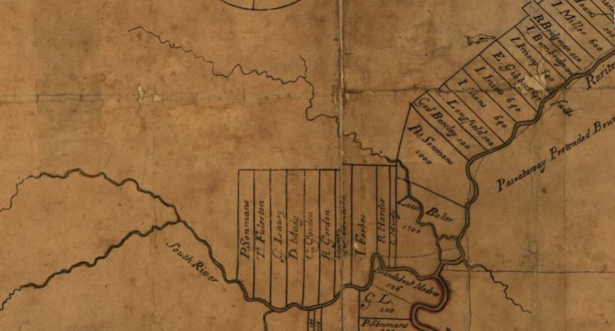
The earliest land transfer was from Native leaders to Thomas Lawrence, The Baker, a NY city merchant. As you can see from the circa 1685 map of the area, his holdings were affirmed by the East Jersey Board of Proprietors.
Map from 1685 showing the Lawrence Brook in relation to the Rariton (sic) River, South River, and land holdings of the time, source: https://www.loc.gov/item/97683564/
CONVEYANCE. Land called Ramawon on the south side of the Raritan River. [East Jersey].
Tract of land called Ramawon bounded by the Raritan and Pisscopeck Rivers.May 1, 1678
TO: Thomas Lawrence (Baker) (of New York; [Lawrence the Baker])
FROM: George Carteret (Sir) (Lord Proprietor); Philip Carteret (Esquire) (Governor of the Province)
PATENT. 1300 acres. South side Raritan River; a creek called PiscopeckIn 1693, the creek, now called Lawrence Creek (Brook), was granted to Peter Sonman, running from near Rocky Hill, all the way to Thomas Lawrence’s grant along the Raritan.
Oct. 20, 1693 TO: Peter Sonmans (Merchant) (of London; Proprietor; Son of Arent Sonmans, deceased, and Frances Sonmans; Brother of Johana Sonmans and Rachell Sonmans)
FROM: Proprietors of the Province of East New Jersey
CONVEYANCE. 38600 acres. Between Milston and Raritan Rivers; beginning at the Partition Line between East and West Jersey; opposite the foot of Rockie Hill; on both sides of Lawrence Creek; to the South River; Middlesex County.
June 7, 1677 Conveyance Record. NOTE: Isarick may have been the father of Wequeheela, who resided in present-day Spotswood.
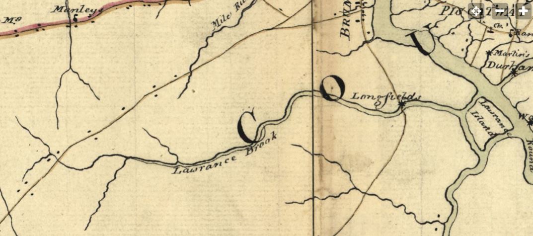
The 1781 map below, drawn by a British Army cartographer, is a general depiction of the stream, and of George’s Road (present-day Rte. 130 in part), George’s Road led from George Rescarrick’s Tavern (circa 1686) in Cranbury to New Brunswick. Below Cranbury, it led to Hightstown, Allentown, Crosswicks and points south. Longfield’s Mill is where Rte. 18 crosses the stream, a stretch known as Westons Mill.
Rich’s next installment will be on the Headwaters of the Lawrence Brook.
In this online “Option Green” presentation, sponsored by the East Brunswick Public Library, LRWP Board President Heather Fenyk will discuss the history of the Lower Raritan Watershed from indigenous to colonial and industrial development to its current status, provide a snapshot overview of the health of the streams and tributaries that feed into the Raritan River, the history of the pollutants in the river and how cleanup has evolved. She will also provide information on how citizens can help restore our waterways through environmental stewardship and citizen science.
By LRWP #lookfortheriver Outreach Coordinator Anjali Madgula
Timescales
When we talk about human caused climate change, often we are talking about time. How much time does it take for a global ecosystem to undergo significant change? How much time does it take for pollution to affect a local community, a whole country, and then a global ecosystem? How much time do our plastics spend in our hands, in a landfill, in an ocean, in the stomach of a sea creature, and as a toxic substance spreading into our communities and bodies? And how much time do we have, to implement change and achieve just and sustainable living conditions for all?
Often, climate issues have to be approached in unique and creative ways because of their slow moving yet massive impacts. In his book, Slow Violence and the Environmentalism of the Poor, Rob Nixon outlines the concept of slow violence, which he defines as the “delayed destruction” that is character of climate disasters that span over decades and centuries, occurring through everyday toxic buildup and greenhouse gas emissions. Unlike violence that is immediate, visible, and sudden, the slow violence of environmental degradation is much more difficult to draw attention to in everyday media, despite being seriously capable of damage. Nixon writes, “How can we turn the long emergencies of slow violence into stories dramatic enough to rouse public sentiment and warrant political intervention, these emergencies whose repercussions have given rise to some of the most critical challenges of our time?” (Slow Violence, 3).
Earth Overshoot Day
People across disciplines are using narratives, statistics, and actions to make visible the long term scale of the climate crisis alongside the need for carbon heavy countries to decarbonize and transform their infrastructure in the immediate present. In 2006, an organization called Global Footprint Network created the concept of Earth Overshoot Day. Earth Overshoot annually calculates the calendar date for when the amount of our resource consumption for that year exceeds the amount of the Earth’s biocapacity (the amount of resources generated by Earth that year). The GFN’s work showcases the climate story across the human and nonhuman in the unique frame of just one year’s biocapacity and consumption.
In the past few decades, Earth Overshoot Day has moved steadily from the middle of October closer to the end of July, meaning not only that we are consistently consuming way more than the Earth generates per year but also that we are consuming more every year. Only in 2020, did Earth Overshoot Day get pushed to August 22nd due to a decrease in our annual ecological footprint from the first half of the COVID pandemic. However, in 2021, the calculations remain on par with the previous trend: Earth Overshoot Day will be on July 29, 2021.
The GFN also calculates an individual country’s Overshoot Day, which tells us when Earth Overshoot Day would fall if the whole world consumed like that country does. If everyone consumed in the manner that the United States of America does, Earth Overshoot Day would have been on March 14, 2021, just barely three months into the year.
In examining these statistics, it is important to reflect on where the onus for climate action lies and how carbon heavy countries harm countries with lower consumption rates on multiple levels, through overburdening the global climate but also by establishing industries and toxic activities in marginalized communities across the world.
Reflection through Local Restoration
Reflecting on the implications of Earth Overshoot Day during this extremely hot summer, invites me to ground myself in the work and movement building of our local communities in New Jersey and the Lower Raritan Watershed. While a global framing is essential, we can document changes in our own ecosystems and build community around stewardship and advocacy to make restoration and resilience possible. We can engage in discussions about resources, energy, and carbon emissions, by drawing attention to the specific issues and experiences of our community here. In order to have the greatest impact, it is important to have as many community members involved!
During the month of July which is marked by the 2021 Earth Overshoot Day on July 29, we can get involved with the new and continued programming of our watershed. The LRWP’s #lookfortheriver campaign has a new instagram page (@lookfortheriver) where you can be up to date with the citizen science work of the FRAMES sculpture in Boyd Park and other #lookfortheriver activities. The LRWP is also launching a stormwater management assistance program to help townships meet their federally mandated stormwater management education requirements.
These programs, amongst others, create spaces for us to navigate the global ecological crisis by protecting the ecosystems we have made a home within.
Citations
Nixon, Rob. Slow VIolence and the Environmentalism of the Poor, 2013. “Earth Overshoot Day” , overshootday.org, July 2021.
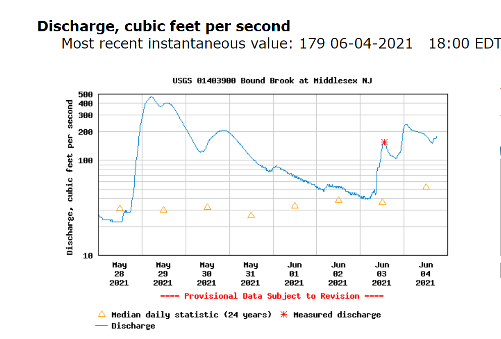
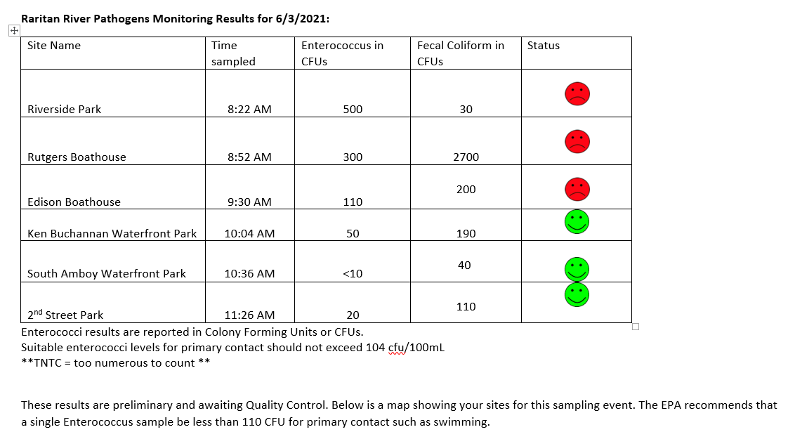
What a soggy week in the Lower Raritan, with 1.56 inches accumulated in our rain gauge in the 24 hours since our water quality monitoring activities yesterday morning June 3. The USGS flood gage shows discharge significantly above the 24 year median daily statistic.
With such significant precipitation please know that our pathogens sampling numbers for six non-bathing public access beach sites captured during June 3, 2021 monitoring are not reflective of the current situation. (See here for more on our pathogens monitoring program):
Enterococci results are reported in Colony Forming Units or CFUs. Suitable levels for primary contact should not exceed 110 cfu/100mL. Pathogens/Enterococci levels are used as indicators of the possible presence of disease-causing bacteria in recreational waters. Such pathogens may pose health risks to people fishing and swimming in a water body. Sources of bacteria include Combined Sewer Overflows (CSOs), improperly functioning wastewater treatment plants, stormwater runoff, leaking septic systems, animal carcasses, and runoff from manure storage areas.
Huge thanks to our partners: Rutgers Cooperative Extension of Middlesex County and the New England Interstate Water Pollution Control Commission.
Field Notes:
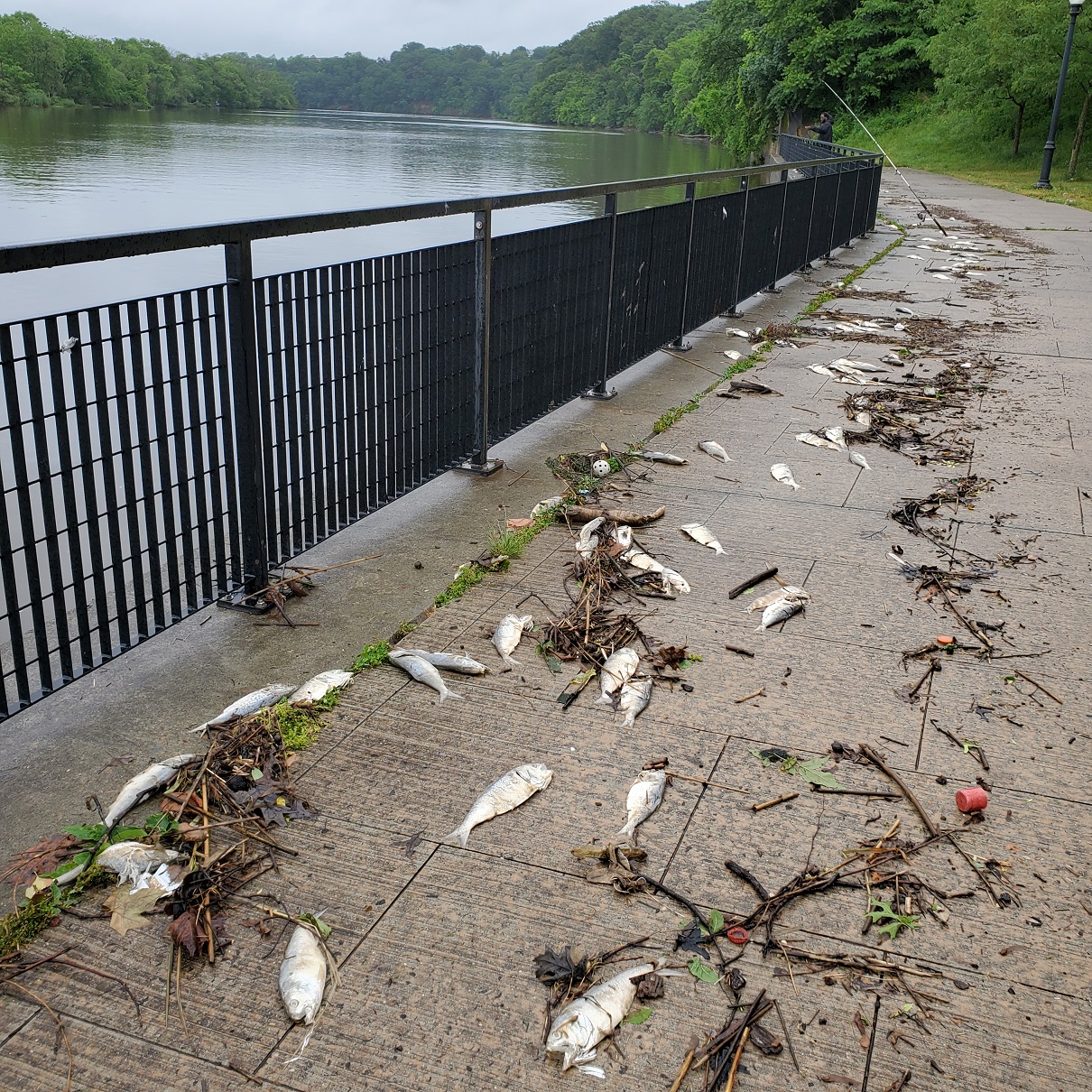
We were concerned we would observe a repeat of the fish kill from the week prior. This photo shows the Boyd Park site on 5.31.2021 after the first wave of heavy rains. Thankfully the numbers of dead fish were far fewer this week.
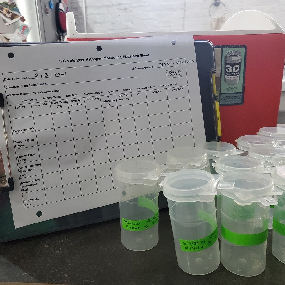
Data sheet, sample bottles and cooler
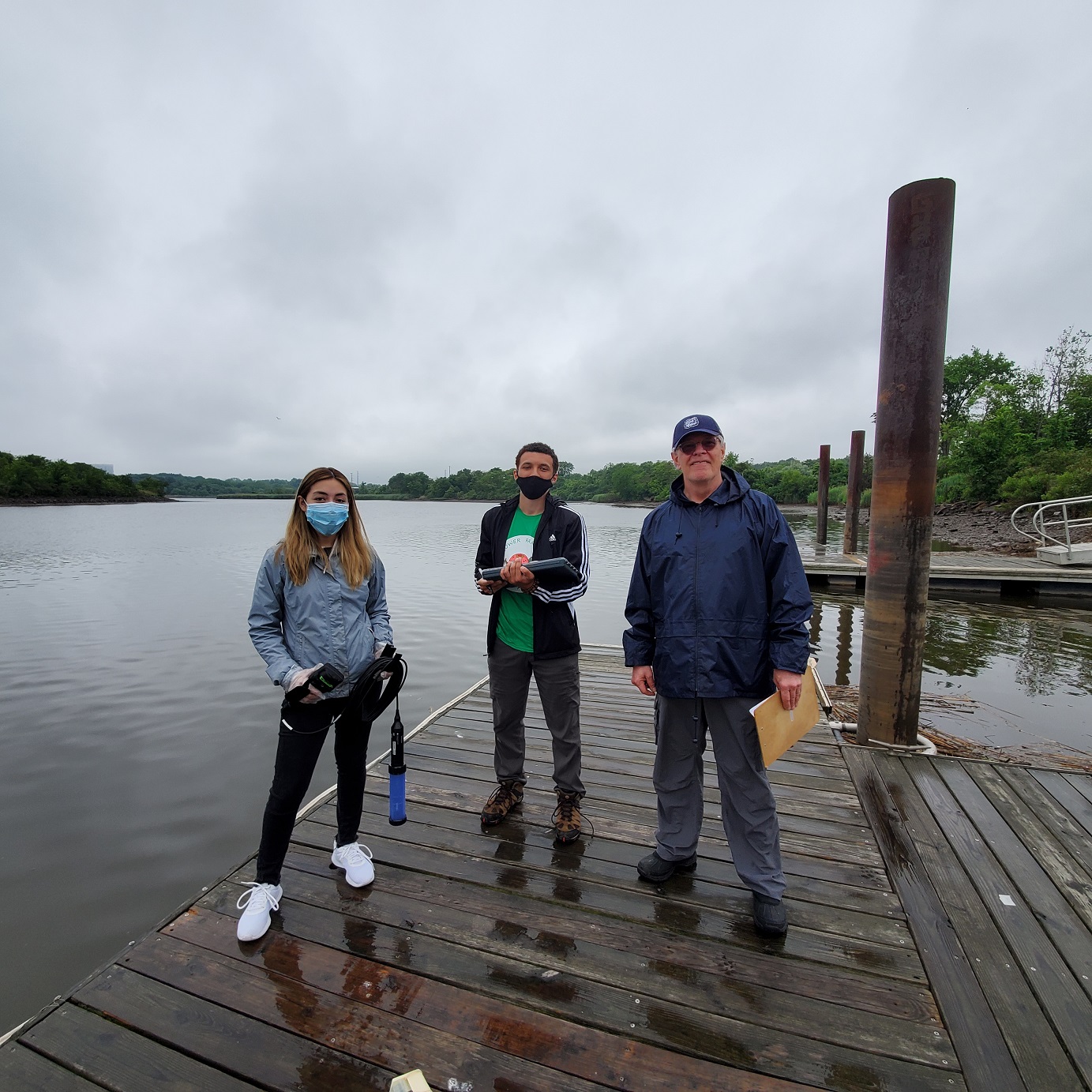
Jocelyn Palomino, Jason Acevdo and volunteer Frank Dahl at the Edison Boat Basin
Please join us Sunday October 3, 2-4 pm for our second “walk in the watershed” in South Bound Brook/Bound Brook with LRWP Board Member and Rutgers Professor David Tulloch! We also expect Green Brook Flood Control Commission Chair Raymond Murray to join us for part of our tour.
Plan to meet at D&R Canal Lock 11 in South Bound Brook. There is limited parking in this lot, however there is plenty of street parking.
We will start our conversation at D&R Canal Lock 11, explore a bit of the canal and talk about its function and its relationship with the health of the river. From there we will walk over to Bound Brook to see the flood control gates by the traffic circle and the levees at Billian Legion Park. We will continue our walk up the Lincoln Ave Bridge to take in views of the Raritan.