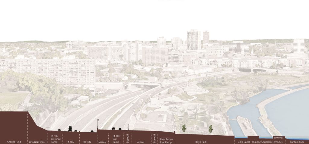
Article and images (except as noted) by Sanja Martic, Rutgers Department of Landscape Architecture Graduate Student.
“Man wants to take the river’s natural storage reservoir and make no compensation for it. The river contends it is against Natural Law and cannot be done. The river is right.” James P. Kemper, New Orleans, 1927.
The Dutch Room for
the River Program (RfR) was conceived in 2007 as an integrated river basin
management strategy for the low-lying flood prone and densely populated areas
of the Netherlands. As part of this Program, water management is conducted via
a specialized regional “Water Board,” working in partnership with the Dutch
National Ministry and the Ministries for Transport, Public Works and Water
Management. Through RfR the Dutch Water Board takes a four-pronged approach to
water management. The four key characteristics of the RfR approach include: 1)
large scale river region landscape architectural design thinking; 2) a focus on
collaboration, with landscape architecture playing a facilitating role; 3)
considering the landscape as a system of layers; and 4) anticipating that
natural processes will change and enhance the design over time.
As in the
Netherlands, significant portions of New Jersey’s Lower Raritan River are in
low-lying densely populated areas. Flood protection is of paramount importance
and a matter of human safety and economic security. However, the Home Rule
focus of New Jersey’s local governance limits the potential for thinking in a
landscape context, no comparable “Water Board” serves as coordinating entity
for water management, flood control prioritizes human land use layers, and
engineering controls trump considerations of natural hydrological processes and
flows. There is much to learn from the Dutch RfR example. In what follows we provide
background information on RfR, and consider the Dutch Water Management approach
in the context of New Jersey’s Raritan River and Lower Raritan Watershed.
Historic Approach to River Basin Management
In riverine areas
around the world, the industrial revolution demanded capitalization of the river’s
territory and its water. As a result, many river basins were heavily
engineered: rivers streamlined, river basins minimized, and creeks and small
streams culverted or replaced by canals[1].
These practices, in combination with development over time, resulted in
floodplains that restricted the river and required repeated heightening of
flood defenses[2].
There was no appreciation for the river ecosystems, and water was seen as a
threat and as something that needed to be controlled. Over time, conflicts arose
regarding use of the floodplain and the its water. And the Industrial
Revolution and subsequent development left behind a lasting pollution legacy:
abandoned infrastructure and degraded water and soil quality. Meanwhile, the
expanding population’s need for potable water and space for a safe habitation increased,
causing a decline in the river basin surface. In recent years, rising intensity
and quantity of extreme precipitation events associated with a changing
climate, coupled with increase of the impervious surface cover, further
complicate water management issues.
Room for the River (RfR) Emergence and Approach
In the Netherlands, traditional water management methods were challenged following destructive floods in 1995, caused by record extreme precipitation events. It was clear that new flood levels required a different approach towards river management. Different approaches to water management call for different methods: many rely heavily on engineering while others emphasize a more natural approach. Room for the River Program (RfR) finds a middle ground. Instead of gradually reducing the area that rivers occupy, this approach allows the river to expand over a larger territory[3]. RfR brings together the worlds of water management and spatial planning, engineering and ecology. Tools are varied and include dredging at one extreme, and measuring spatial quality on the other, and they are put into service of two main objectives: improving safety by reducing flooding of riverine areas, and “contributing to the improvement of spatial quality of the riverine area”[4]. Although hard to quantify, this second goal is particularly interesting from the landscape architecture perspective as it considers quality of the space.
Spatial quality
within the RfR approach is defined as “a property of the resulting landscape
after a plan has been implemented.”[5]
A good design is further judged by three criteria: hydraulic effectiveness,
ecological robustness and cultural meaning and aesthetics. Cultural meaning and
aesthetics criteria call for enhancing the scenic beauty, tailored to a range
of sites that could be classified as natural, urban or countryside. Ecological
robustness endorses designs that are long lasting, self-sustained, build upon
natural processes, and are low maintenance. This is achieved through combining
natural hydrology with morphological and biotic processes to achieve stability
in riverbed and floodplain.[6]
This means that plans have to be functional in the case of floods, but at other
times must accommodate livability, wildlife habitats and areas usable as a public
good. Design is informal and natural while providing maximum access for recreation,
with spaces intended to reveal the spirit of each individual site of
intervention.
Room for the River (RfR) Implementation and Practical Measures
In the Dutch
model, spatial quality assessment requires development of a special Q-team
(quality team) composed of members from different but complimentary
disciplinary backgrounds. The Q-team’s role is to produce an independent
recommendation on enhancing spatial quality through coaching designers and planners,
peer review of the designs and plans, and regular communication to the
Ministries of Transportation, Public Works and Water Management[7].
This calls for significant transdisciplinary cooperation between planning and
design, with an equal role for the landscape architect, urban planner, river
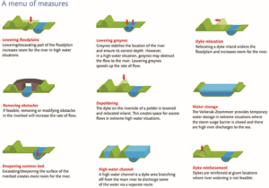
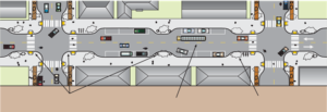
engineer, ecologist and physical geographer. Practical measures (Figure 1) are
applicable at large scale and fall into three categories ranked by complexity
of integration of flood risk measures with spatial measures. These categories
include technical measures (deepening the river bed, lowering groynes,
strengthening dikes), measures within the banks (lowering the floodplains,
removing obstacles), and measures beyond the banks (high-water channel
building, dike relocation, water storage). In addition to evaluating project’s outcome,
the team also evaluates the quality of the integrative collaborative design
process.
Figure 1: Different types of measures in the RfR program Source: Practical Measures, from Room for the River Fact Sheet
Precedent for RfR in the United States
The RfR approach
is not entirely new to the United States. An early similar effort was forwarded
in New Orleans in 1927, following devastating flooding events in the
Mississippi River delta. Like the Dutch who relied on dikes for flood
protection, the Mississippi delta community relied on constant raising and
enforcing levees, increasingly restricting the surface size of the natural
flood plain. The 1927 flood prompted a reevaluation of the Mississippi River
management approach. Official Congressional hearings were held and involved the
U.S. Army Corps of Engineers, the Mississippi River Commission and expert
witnesses such as Gifford Pinchot[8].
Discussion revolved around engineered control of the river proposed by the Army
Corps of Engineers, and an approach in which nature would be allowed more
leeway[9]
supported by Pinchot, James Kemper and others. The latter view resembles the
RfR approach as it calls for allowing more room for the river through widening the
flood plain.
RfR Methodology
1. Large-Scale Design (Entire river region)
The large scale landscape architectural design approach considers “not only detailing of small-scale elements, but also at the scale of the river system as a whole”. [10]
2. Collaboration
The landscape architect plays a central
role of coordinator between planners, architects and other partners. Fliervoet
and Den Born studied and evaluated the RfR’s collaborative process from a
stakeholders’ perspective. They concluded that the success of the approach is
highly dependent on the cooperation and collaboration of multiple entities
occupying the watershed with emphasis on the local knowledge. The biggest
obstacles to collaboration stated by the participants, were the lack of an
overarching, integrated maintenance vision and a lack of coordination between
the authorities.[11]
3. Considering the Landscape as a system of layers
o Basis of Landscape (soil, water,
ecosystems)
o Network Layer (roads, waterways energy
infrastructure)
o Occupation and Land Use (living,
working, recreation)
o Time Layer (all layers develop within their
own time scale)
4. Creating Conditions: Responding to natural
processes
Natural processes
are expected to change and enhance design over time.
Applying the RfR Methodology to the Raritan
Large-scale Design of the Raritan River Floodplain and
Regional Network
The first characteristic,
the large scale of design as applied to the Lower Raritan, requires creating a
comprehensive masterplan with projects spanning the entire Raritan watershed. RfR
site plans would become small parts of a large Raritan Watershed Masterplan. The
masterplan would be guided by a comprehensive vision of integrated water
management, with a regional greenway connection as an integral part. Directly
connecting the City of New Brunswick to the greenway network would be a key
component of the masterplan, as New Brunswick is the largest settlement on the
banks of the Raritan River. Collaboration between many governing bodies is
essential. At the federal level the governing bodies to involve include USACE,
USCG and the Advisory Council on Historic Preservation. At a state level
governing bodies to involve include NJDOT, NJDEP and Land Use Regulations and
Ecological Services Field Office. Regionally the Delaware and Raritan Canal
Commission and counties such as Middlesex, Somerset, Hunterdon and others
should be involved. At the local level the municipalities along the Raritan
River banks including New Brunswick, Piscataway, Franklin Township etc. would
require representation.
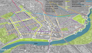
Large scale design requires examination of large-scale network connections. Analysis in the Raritan River context reveals several greenway network opportunities (Figure 2). Metropolitan areas of New York City and Washington D.C. are roughly framed by the Appalachian Trail to the North and the proposed alignment of the East Coast Greenway to the South. They are further enclosed by the major East Coast rivers that bisect the Trail and the Greenway on their way to the Atlantic Ocean. The Hudson River Valley to the East, the Delaware and Lehigh National Heritage Corridor, and the Chesapeake and Ohio Canalto the west all form a regional trail system matrix. This blue and green matrix provides unique opportunities for cross connections of the corridors and interactions with nature and culture to one of the world’s densest contiguous urban populations.
The East Coast Greenway is an aspiring walking and
biking route stretching the length of the US East Coast with southern terminus
in Key West, Florida and northern Maine. Once actualized, the East Coast
Greenway will be 3000 miles long and epitomize the bond between communities and
nature by connecting the exist green open space along its route into a unique
linear corridor. Initiated in 1991, with forming of the East Coast Greenway
Alliance, the vision of Greenway designers, “represents a commitment to public
health, environmental sustainability, economic development, and civic
engagement”[12].
The existing Appalachian National Scenic Trail, which
partially passes along New Jersey’s northern border, is currently the longest
hiking footpath in the world at 2190 miles long[13].
It was first proposed by a regional planner Benton MacKaye in a 1921 document titled “An
Appalachian Trail: A Project in Regional Planning”. MacKaye’s vision initiated the idea of land
preservation for the purposes of recreation and conservation. The idea started to materialize in 1925
and was actualized in 2014 when the last stretch of the Trail was formally
acquired and protected. Today, the trail
is visited by over 3 million visitors a year as it bisects fourteen US States
from Georgia to Maine.[14]
The East Coast Greenway’s proposed alignment crosses
the narrow waist of New Jersey using the D&R Canal Park as a major
junction. Canal Park’s Masterplan recognizes the most important quality
possessed by this linear park to be the role it can perform as a connector.
Canal Park no longer links New York City and Philadelphia, but it does join
central New Jersey communities, different land forms and different kinds of
natural areas, and connects New Jersey with its heritage[15].
Extending the Canal’s connection back into the city of New Brunswick would
align with the Canal Commission’s Masterplan and benefit New Brunswick’s future
development.
The Delaware and Lehigh National Heritage Corridor
runs along the Delaware River on the Pennsylvania side, parallel to the D&R
Canal Park. It is an indirect connection between the proposed East Coast
Greenway, through the D&R Canal Park to the Appalachian Trail. It is also an
example of a linear park run by a nonprofit organization, while Chesapeake and
Ohio Canal is a linear park that is part of the National Park system. The Chesapeake
and Ohio Canal is another significant connector between the Appalachian Trail
and the East Coast Greenway close to a major metropolitan area.
When the Delaware and Raritan Canal was built in the
1930s it permanently linked the Delaware and Raritan watersheds, creating opportunities
for connection. Since that time, construction of Route 18 through New
Brunswick, which established a several mile stretch of roadway immediately
adjacent to the Raritan, severed this historic network connection, in
particular in the area between Buccleuch Park and the Landing Lane Bridge. Today,
the City of New Brunswick’s unique geographic position could once again benefit
future development should access impediments to the D&R Canal Park be
removed, resulting in expanded access to not only Canal Park but regional
networks like the East Coast Greenway. There would be many mutual gains: the local
community would have better access to nature and everyday recreation and
day-hiking without having to drive to the trail. New Brunswick’s rich local
history would add to the richness of the trail’s experience. The local economy
would benefit from hiking and biking traffic generated by the Greenway.
Finally, being a part of the future East Coast Greenway’s shared vision could
be an invigorating driver of the nature stewardship and future community and
economic development.
Figure 2: East Coast Greenway Network Opportunities
Collaboration of Local, Regional, National and State
Partners
Collaboration and
coordination, conducted by a landscape architect, may include working with a
variety of professional partners on a local level. In addition to planners and
architects, other professions to engage include social scientists, geographers,
ecologists, river engineers, biologists, historians, archeologists and civil
engineers.
Considering the Raritan River Floodplain and Watershed
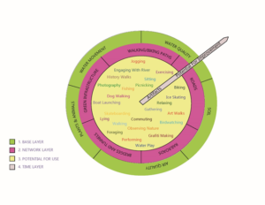
Landscape as a system of layers
The RfR “system of
layers” approach consists of a base layer, network layer, potential for use
layer and time layer (Figure 3). Layers provide a basis for site evaluation within
the Lower Raritan. Expanding the original RfR methodology, we have conceived of
each of the four categories of layers as worth 25 points for a total of a
100-point evaluation system. The lower the score for specific site, the better
the opportunity for enhancing it.
Figure 3: Adopted Diagram of Layers of Landscape
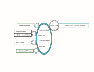
For example, considering New Brunswick in relation to the regional greenway network, the four areas identified as having the best opportunity for creating connections between the New Brunswick and regional greenways are the Key Connector Streets (Urban Core Green and Blue Corridors), Waterfront Access Points, Raritan Bike Path, and the “D&R Canal Link”(Figure 4). These] specific sites should then be evaluated for their soil, water and air quality within the base layer, and for the existing roads, railroads, bridges/tunnels, walking and biking paths and green networks within the network layer. The Network Layer evaluates the existing networks presence and connectivity. Points (0-5) are given for the presence of the networks within the site and more points for their current connectivity. All the sites have a presence of at least one network, however in some cases those networks are enhancing and in others reducing walking and biking connectivity. Increasing connectivity becomes a goal for this layer.
Figure 4: Simplified Connections Diagram
The Base Layer
evaluates the soil, water, air, plant and animal life conditions of the
landscape. 0-5 points for soil quality are allocated depending on its
permeability as well as its ability to support life. In the urban environment
soil is often covered by pervious surface or is heavily compacted resulting in
a low rating. Water movement is evaluated based on the speed of its movement
within the site. Faster movement (poor infiltration) is rated lower. Water
quality is associated with the ability of site to treat the stormwater runoff.
Water that leaves the site cleaner results in higher points. Air quality
depends on the site’s micro location. Sites near major roads with little
vegetation are rated lower. Finally, existence of plant and animal life is
rated depending on a level of presence. Based on the rating, design goals that
emerge are: increasing surface permeability, slowing down runoff by retaining
water in the landscape for longer periods, decreasing soil compaction, and creating
conditions that support more plant and animal life.
Our addition to
the methodology also includes expansion of the “potential for use layer” by
which each of these sites are evaluated for their potential to support any of 25
different activities that could take place within the area once it is
redesigned. The Potential for Use Layer allocates one point for each activity
that can currently take place within an area. The goal for this layer becomes
increasing the number of future potential use of the space.
Finally, the time
layer evaluates presence of historic and cultural artifacts on one end and a
potential for future ecosystem health improvement on the other. Sites that
contain historic and cultural artifacts are rated higher, as well as the sites
that will be able to, over time, enhance the ecosystem health. Ecosystem health
is prioritized over the existence of historic and cultural artifact. For
example, a city street has less potential for the improvement of the future
ecosystem health than the river bank.
Figure 5: Proposed Connections Diagram
The redesign of
the existing key connector streets within the City of New Brunswick enhances
the biking and walking experience, while leading to the waterfront access
points. Commercial and Joyce Kilmer Avenues are green corridors, chosen for
their proximity to the local schools, green open space, highest population
density and wide traffic lanes. These two thoroughfares have a great potential
for “road diet” interventions, such as narrowing traffic lanes and adding
bumpouts at street crossings in order to calm traffic and thus enhance safety of
pedestrian and bicyclists. They would further create opportunities for bringing
nature closer to the local communities by becoming way finders for the Raritan
River as well as the green corridors with more pervious surface and vegetation
(Figure 5).
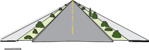
Existing Roadway Surface
Bike lanes, pervious surface
Figure 6: Green Corridor Intervention Source: Oregon Bicycle and Pedestrian Guide
Route 27 or French
Street and Hamilton Street are already main routes of access that are further
enhanced by adding new and improving existing bike lanes, and improving
pedestrian experience by adding bump outs and lowering curbs. Similar
interventions could be applied outside of the immediate study area. Franklin
Township’s Franklin Boulevard is the next such opportunity. The existing Mile
Run stream corridor, in conjunction with the key connector streets, forms a
matrix of river connections. The Mile Run stream corridor is now accessible
through this matrix, offering further opportunities for engagement with water
and nature.
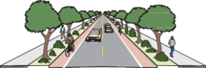
Figure 7: Bumpouts add sidewalk space, provide space for rain gardens, bike parking, etc. and shorten crossing distance. Minimum width lanes slow traffic.
Source: “Main Street: When a Highway Runs Through it”, Oregon Downtown Development Association
Access to the waterfront
is strengthened using various traffic calming techniques such as raised,
textured crossings, lowered speed limit and narrowed traffic lanes. These
approaches ensure safety and an enhanced pedestrian experience. Redesigning the
Raritan bike path by adding access points, widening its surface, and adding
small, localized interventions helps create a sense of place and wayfinding.
Materials and forms chosen for intervention help to further connect community
to the unique industrial and postindustrial history and ecology of the place.
Finally, the “Canal Link” links fragmented biking and walking paths ending
within the area of the River Road, Landing Lane, Buccleuch Park and Spillway,
through an elevated walkway bridging the impediments. This walkway becomes the
final interlocking link restoring connection to the D&R Canal Park, East
Coast Greenway and the Raritan.
A final key characteristic of the RfR program requires considering how including natural change over time can be integrated in the designed system, so that it could start functioning as a natural system. Within the landscape architecture field, time is always an important element considered in designing a landscape. The question: “How will a landscape change throughout the years?” is a core design consideration. However, change is usually considered as it relates to human use and needs. In the RfR case the emphasis is on the health of the entire ecosystem, and the ability of landscape to be “managed” by natural processes, thus making it self-sustained and supportive for all living beings. Choices of materials and forms should be made considering this final concern.[
[11] Fliervoet,
van den Born, and Meijerink, “A Stakeholder’s Evaluation of Collaborative
Processes for Maintaining Multi-Functional
Floodplains.”,p 185.
The LRWP is often asked to identify top environmental issues facing our Central Jersey watershed communities, and every year we develop a “Top 10” list of concerns. Through 2019 we will feature one concern a month on our website, exploring that issue (and potential solutions) in more detail. This month we consider the problems caused by culverting, piping, developing over or otherwise “hiding” our streams, and provide strategies through which we can find them again.
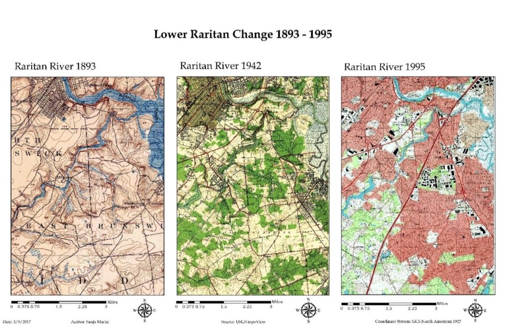
The Lower Raritan Watershed is full of ghost streams. Entrepreneurs, town councils, industry, and home owners have long buried streams to develop their land and businesses, to expand their towns, to build their homes, and to address public health concerns. The result is centuries of piping, culverting, construction, and development that have hidden the vast majority of streams and rivers in our urban landscape.
“Lower Raritan Change: 1893-1995” This graphic show gradual encroachment of development and associated disappearance of tributaries to the South River and Raritan River over a period of approximately 100 years. Sanja Martic, 2017.
The impact of “hiding” so many of our streams is devastating. Lower Raritan communities are alienated from our waterways and historic ecologies, habitats are degraded, water quality is compromised, and stormwater runoff and flooding intensify. Not only in the Lower Raritan, but throughout the United States and globally, these impacts are most acutely felt in areas with low socioeconomic status and vulnerable populations. In the face of climate change and increased precipitation and runoff, these communities bear disproportionate risk and adaptive burden.
We know that healthy, open streams play an important role in stormwater management. In a healthy stream, stormwater gets absorbed and gradually released by soil and plants. An open stream not only slows and controls stormwater surge, it also provides habitat for wildlife, and provides the aesthetic benefits of cool spaces and greenery.
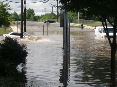
A Stream (Mile Run Brook) Runs Under It Flooding on Joyce Kilmer Avenue at the Mile Run Brook culvert strands students at New Brunswick’s Greater Brunswick Charter SchoolPhoto: Charlie Kratovil, 2016
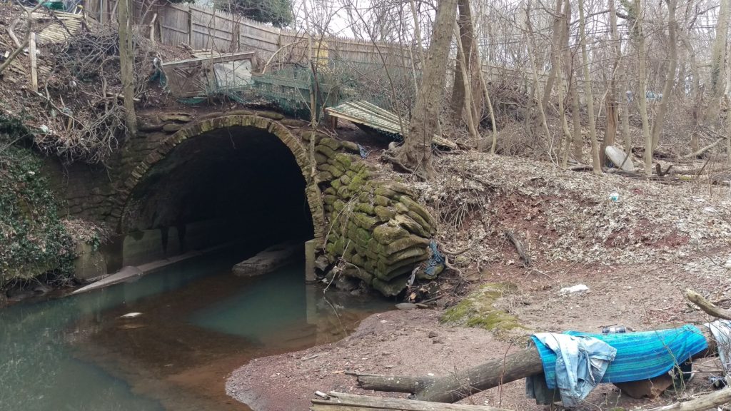
What is a culvert? A culvert is a tunnel carrying a stream or open drain under a road or railroad.Stagnant water in Mile Run Brook under New Brunswick’s Hamilton Street culvert. Photo: Heather Fenyk, 2019
Streams, especially small ones, also play an important role in improving water quality. A healthy stream ecosystem can remove excess nutrients, sediment, and other contaminants from water before it flows into our Rivers, Bays or Oceans. Recent research by the Environmental Protection Agency found that nitrates—nutrients that can become pollutants—travel on average 18 times further in buried urban streams than they do in open streams before they are taken out of the water column. This means that in areas with many buried streams like the Lower Raritan Watershed, larger water bodies including Raritan River and Raritan Bay receive more pollutants than if the waterways upstream were open and healthy and serving to filter pollutants as stormwater runoff travels its course.
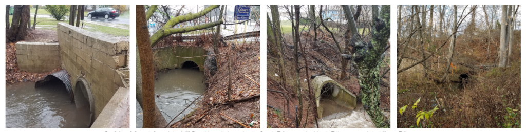
Except for the smallest tributary, all branches of Mill Brook first meet daylight at the end of concrete pipes.Outfalls of, from left to right, Mill Brook’s main branch, the South Tributary, the North Tributary, and the Kilmer Tributary (Highland Park and Edison).These photos are part of Susan Edmunds’s Storymap: “Mill Brook: A Portrait of an Urban Stream”
Of course the best first action with respect to keeping streams healthy is to avoid culverting, piping, constructing over or otherwise developing them. However, in already heavily developed areas like the Lower Raritan Watershed, much damage has already been done. In some of our Lower Raritan towns more than 50% of surfaces are paved over, including all waterways that were in evidence on maps from the 1800s.
Change in time in impervious cover in the Lower Raritan Watershed from 1995-2012
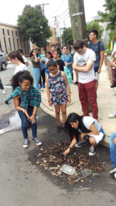
Walk down most any of our main streets and you are likely to “walk on water” without any awareness of what is beneath your feet. If you pay careful attention however, as students did during our 2018 summer camp, you can hear the streams and trace their course, even if you cannot actually see them. Learning about our landscape, and “finding” our hidden streams is the next best action to take in protecting them.
Lazos America Unida/LRWP Summer Camp looks for the buried Lyell’s Brook
Learning to decipher our landscape, and trying to “find” our hidden streams are central to the LRWP’s new #lookfortheriver campaign.
The LRWP is building the #lookfortheriver campaign to bring attention to the problems of “hiding” or disappearing our streams, and to identify ways of finding them again. In addition to teaching folks about the landscape in fun ways, this involves collecting stories by volunteers and contributors who take the time observe and document their area streams, and who highlight the great benefits of landscape connectivity. Joe Mish’s most recent February essay is a great example: Along the South Branch Connected. Margo Persin’s year of blog post’s about Ambrose Brook is another.
#lookfortheriver activities include our newly launched “Watershed Highlights and Hidden Streams: Walking Tours of the Lower Raritan Watershed,” to be led by Rutgers Professor and LRWP Board Member David Tulloch. These walks will look at landscape connections to our waterways and what this means. The series kicks off on Sunday March 16 close to the Rutgers campus, with exploration of the connections between Buell Brook and the Raritan, connecting Johnson Park and the historic Raritan Landing with the Eco Preserve.
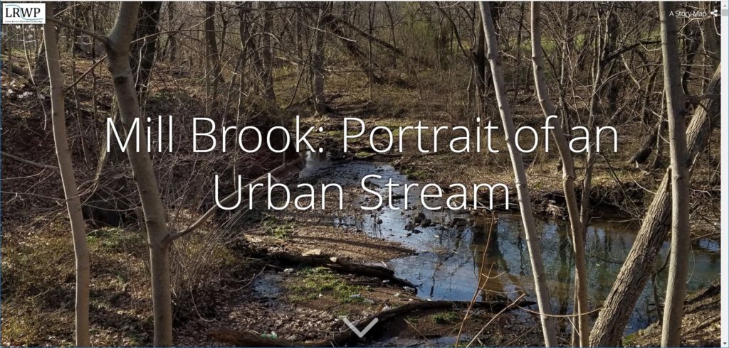
#lookfortheriver includes working with volunteers to understand how our landscape works, where it doesn’t, and how to fix the problems we observe. Susan Edmunds’s research into the history of Mill Brook, and her careful study and documentation of the stream (see her online Storymap Mill Brook: A Portrait of an Urban Stream) lends tremendous insight into landscape functions of a relatively forgotten stream. Susan will present on this project in at the Highland Park public library on Sunday March 24. Joining Susan will be Rutgers student Jillian Dorsey, who will highlight findings from her thesis research on Mill Brook that shows how property owners can protect their urban streams. We hope these efforts will further mobilize municipal action to restore local streams, and that they will inspire homeowners in proper maintenance of waterway-adjacent homes. In fact, this work has already inspired the Highland Park Council to partner with the LRWP for a multi-site clean-up of Mill Brook, scheduled for Sunday May 12 – please save the date!
The legacy of development, culverting and piping that has hidden our streams exacerbates flooding and pollution transfer. It has disconnected us from our waterways and from our land. This is disastrous for our communities, but we are learning new ways “find” our streams again and fix these problems. Join us in online to discussions, at meetings, or for our “Hidden Streams Walking Tours”. Or simply start exploring the watershed on your own. Give close attention to landscape cues – the sound of rushing water in a storm sewer, collections of sediment and debris in low lying areas, and dense growth of trees and weeds. In this way we connect to our landscape and waterways, imagine their past, and can begin to plan for a future of “finding” and restoring them.
Article by LRWP Raritan Scholar Intern Daniel Cohen
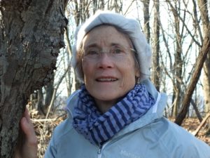
Highland Park resident Susan Edmunds is the first “Streamkeeper” for the Mill Brook, a tributary of the Lower Raritan Watershed.
LRWP Streamkeeper Susan Edmunds, a 30 year resident of Highland Park, lives adjacent to a tributary of the Raritan River called Mill Brook. During the time Susan has lived alongside the Mill Brook, she has become committed to the environmental sustainability of this stream. As part of a Rutgers Environmental Stewards program internship, conducted with the Lower Raritan Watershed Partnership, Susan documented the condition of the Mill Brook through historical research and photography, synthesizing this information in an online “storymap” titled Mill Brook: Portrait of an Urban Stream.
Susan is a strong advocate for what she terms “a new understanding” by all stakeholders in order to remedy the serious threats which endanger the environmental viability of the stream. I walked along the waterway with her as she highlighted several major environmental challenges facing Mill Brook. These include illegal dumping of commercial and residential trash, and wash off of chemical herbicides and fertilizers from nearby lawns into the stream. This wash off is part of what is called “non-point source pollution,” and includes not just herbicides and fertilizers, but also animal waste, motor vehicle oil and other chemicals.
As we continued walking downstream, Susan told me that in recent years Mill Brook has experienced intensified erosion and flooding events. She pointed out the proliferation of driveways, parking lots, and walls — what is known as impervious surfaces — that prevent the natural absorption of rainwater into the soil and results in “stormwater runoff.” She then explained how excessive amounts of stormwater runoff exacerbates erosion of lawns and damage to residential structures, and also carries downstream pollution in the form of silt and gravel and non-point pollution.
Even before becoming part of the LRWP’s inaugural team of Streamkeepers, Susan has long been committed to restoring the natural beauty of Mill Brook. She regularly removes debris from its banks, and replaces invasive plants with native flora. In her role as Streamkeeper she has added regular monitoring and reporting on stream health. She understands that while her isolated efforts are important, care of Mill Brook requires a long-term commitment by Edison and Highland Park residents as well as municipal authorities.
Susan sees that inspiring a collective commitment to the health of Mill Brook is a crucial part of her role as Streamkeeper. Her goal is to encourage others to appreciate the Mill Brook as much as she does. She strongly believes that when residents learn about and visit the stream they will be motivated to care for it. In this sense she says she hopes her tenure as Mill Brook’s formal Streamkeeper will be short – and that her work will inspire someone else to become a steward and “Streamkeeper” of the stream.
Susan gave me examples of other stewardship she would like to see. For example, schools in the vicinity of the Mill Brook should encourage students to participate in restoring the waterway. And homeowners and business owners who live and work in proximity to the Mill Brook should treat the waterway as the living system it is, and give it room to serve as flood control and to allow for native riparian habitat (not lawns!) to become established. Susan believes that small steps like these will not only help ensure the environmental sustainability Mill Brook, but of all of our endangered watersheds.
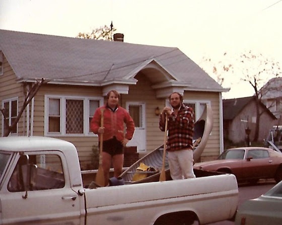
As elated as Lewis and Clark upon reaching the Colombia River, Jimmy and I proudly pose with our intrepid craft , “The Wild Turkey”, in the back of an old Ford Pickup
The eternal waters of the South Branch flow with memories and reflections, kept safe for those who have opened an account along its banks and written their story upon its waters.
I have a longstanding account, opened years ago, from which I make occasional withdrawals. The memories are recalled, polished with reflection and returned for safe keeping.
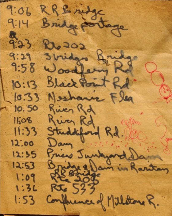
Hazy events, prompted by a scrap of paper that fell from one of my books, brought a canoe journey made decades before, into sharp focus. The lined, yellow paper, in my handwriting, was a record of time and places noted on a trip down the South Branch to the sea with my good friend Jim Serchio.
Jim worked across the hall from me in the pharmacology department at J&J. Intrigued by my stories of paddling solo to the mouth of the Raritan River; Jim recruited himself to join me on another run to the sea.
A hasty plan was hatched and a day chosen. We would launch from Main st in Clinton and paddle down to Keasbey. I would then walk to ‘Billy Vack’s Loop In’, an old iron workers bar located under the Parkway bridge, phone my brother-in-law, and get a ride in his pickup truck to my parent’s home, about three miles away.
The chosen canoe was my old canvas covered 1910 Old Town OTCA 16 named the “Wild Turkey”. Now stripped of canvas and covered with fiberglass, the hull was painted a flat, dead grass green and weighed in at about 85 pounds.
No cooler, just a couple of blue cushions and two guys in the canoe headed downstream. Jim was brilliant guy, studying biomedical engineering. I suppose it was his scientific inquisitiveness which finally prompted him, once we were underway, to ask, how long would the trip take. In my best carefully calculated estimation, I answered, “pretty much all day, we should be there before dark”.
As we passed under interstate 78, just after launching, I noted the time on my scrap of paper. Every time we passed a landmark, clock time was recorded.
Route 202 was reached at 9:23 am.
Looking over the sequence of shorthand notes, I now realize we had paddled under and over landmarks that are now gone or restored differently from their original form. Many of the metal bridges have been reconstructed over the years, their fieldstone supports now replicated by fieldstone veneer. I counted five bridges between Clinton and rt 31. The old dam we portaged below Dart’s mill is now essentially washed away. One bridge downstream of Neshanic station was not yet constructed. The scenery on the same trip today would be quite different.
Route 206 was reached at 1:09 pm
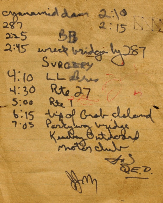
One entry made at 2:45 just before the second downstream pass under interstate 287 makes me smile; I wasn’t smiling then. I recorded the word ‘surgery’.
There was the wreckage of an old wooden bridge just before the last pass under I 287. It blocked our passage so we had to go up and over. As we set the heavy boat down on the rough planks, we did not see a huge spike that punctured the hull below the water line on the starboard side. The situation was looking grim as we were about to enter tide water on the last six hours of the trip. This meant navigating a running tide and staying clear of the main channel to avoid the large wakes churned up by tugboats and deep hulled pleasure craft.
Undaunted, we set the boat back in the water and began down river to see how bad the leak was. It was bad, real bad. How were we possibly going to finish. Pulling to shore, we looked around the debris, left by high tide, for a possible solution. Seeing a piece of yellow polypropylene rope, I had a flash of brilliance. As a kid I loved playing with fire, burning all sort of material including little plastic soldiers. The drops of melting plastic would quickly cool to form rock hard globs and even make a neat hissing sound as it dripped. On a hunch, I took the piece of rope, set it ablaze and dripped the plastic into the large hole in the hull. A perfect watertight fit and we were on our way.
At 4:30 we passed under rt 27, the low water encountered from 287 to Landing Lane Bridge road really slowed our progress. Now we had to deal with the wakes of large watercraft, which showed no mercy to two guys in a canoe. The resultant waves forced us to divert course, turn the bow into the wake and then re-correct to head downriver.
We passed the old drydock across from Crab Island at 6:15 and finally reached our destination under the New Jersey garden state parkway bridge, the former site of the Keasbey Outboard Motor Club, at 7:05pm.
While Jimmy entertained the bystanders, I headed up to Billy Vack’s to call my brother-in-law.
When I returned to the boat and Jimmy, someone asked where we put in. We were actually embarrassed to say, Clinton. We figured they wouldn’t believe us.
Our ride soon arrived and we could finally relax. We did it! Paddled from the NJ highlands to the Mouth of the Raritan river in about 12 hours in a 1910 Old Town canoe pressed into service for an epic journey to the sea.
Jimmy passed away a few years later from a medical procedure gone badly.
I still have the canoe and think fondly of the epic river journey shared with my good buddy Jim. The diary of times and places serves as a reference for memories and the ever changing river landscape.
Two of three pages from the ship’s diary, documents the journey of “The Wild Turkey” and its crew, serves to sharpen the memory of a dash to the sea by two friends in a turn of the century canoe.
Author Joe Mish has been running wild in New Jersey since childhood when he found ways to escape his mother’s watchful eyes. He continues to trek the swamps, rivers and thickets seeking to share, with the residents and visitors, all of the state’s natural beauty hidden within full view. To read more of his writing and view more of his gorgeous photographs visit Winter Bear Rising, his wordpress blog. Joe’s series “Nature on the Raritan, Hidden in Plain View” runs monthly as part of the LRWP “Voices of the Watershed” series. Writing and photos used with permission from the author.
Bear have no need to read signs, much less pronounce the names of obscure creeks, to figure out where they are going. They just put one foot in front of the other and see where it leads.
Two yearling bears curled up to sleep in a jumbled embrace, to form a single pile of pulsating fur, from which random legs protruded.
Upon waking, one bear walked downhill 500 paces to its right, the other 500 paces left, each bear seeking to satisfy its thirst in the nearby streams.
Rested and full of adventure, thirst satisfied, both bears began to follow their respective stream in the direction the water flowed.
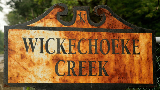
One bear followed Plum Brook to Wickecheoke Creek and ended up on the Delaware River, while its sibling rambled along the Second Neshanic River, to the First Neshanic River, to the Neshanic River, to the South Branch of the Raritan River, to the Raritan River
The two streams, arising from springs, on each side of a common ridge, a mere half mile apart, lead to the state’s opposite coasts. Together the streams form a direct pathway from coast to coast.
We live in a provincial world defined by geopolitical borders, reinforced by the scale of our self-imposed home range. When we travel US route 1 in New Brunswick, we never consider that if we go straight, instead of turning into Chipotle, we end up in Caribou, Maine or the Florida Keys. Same situation as the two bears.
Whether tracing the tracks of a rambling bear down a watery trail to the coast, or a paved highway to opposite ends of the continent, we begin to see a connectivity to distant places. Artificial borders fall away and perspective comes into focus. Taken to the highest resolution, we see that celestial events in the cosmos dictate the requirements and conditions for life on earth.
Adjust the resolution and closer to home we see the Atlantic flyway, a major bird migration route from the arctic to Mexico. Events at either end of the spectrum and along the flyway, can have a dramatic impact on population dynamics of many species.
Preserved lands like the Rachael Carson National Wildlife Refuge in Maine and the Edwin B. Forsythe National Wildlife Refuge in New Jersey are just two of many areas critical to migrating, nesting and overwintering avian activity. Private lands cannot be overlooked and must be appreciated for their valuable contribution outside established state and federal refuges and wildlife management areas.
On a smaller scale, though still expansive, is the critical need for linear greenways in an area broken into isolated segments of habitat.
Many reptiles, amphibians and furbearers are impacted. Isolated populations require a critical amount of genetic variation to remain viable into the future.
Slow moving turtles such as the bog and eastern box turtle are especially threatened. They are now exposed to predators and cars on their journey to lay eggs or migration forced by habitat loss. To celebrate the establishment of isolated patches of open space is misplaced, if a pathway is not considered.
Concerned with isolated habitat and lack of greenways connecting them, the State of NJ, Dept of Environmental Protection, Natural and Historic Resources, Div of Fish and Wildlife, has established a program to examine the impact of isolated habitat and genetic variation. Their program is CHANJ- Connecting Habitat Across New Jersey.
“The goal of this project is to collect DNA samples from a variety of native, terrestrial mammal species across NJ that represents the spectrum of movement capabilities. The genetics analysis will help us understand the impact of landscape fragmentation and road barriers on wildlife mobility.”
I have volunteered to participate and collect tissue samples from roadkill or harvested animals. Please contact me if you spot a fresh roadkill other than deer; jjmish57@msn.com
Far away places exist only in our limited imagination, programmed with a distorted sense of scale. Put one foot in front of the other and see where it leads.
Author Joe Mish has been running wild in New Jersey since childhood when he found ways to escape his mother’s watchful eyes. He continues to trek the swamps, rivers and thickets seeking to share, with the residents and visitors, all of the state’s natural beauty hidden within full view. To read more of his writing and view more of his gorgeous photographs visit Winter Bear Rising, his wordpress blog. Joe’s series “Nature on the Raritan, Hidden in Plain View” runs monthly as part of the LRWP “Voices of the Watershed” series. Writing and photos used with permission from the author.
Did you all get caught in the snow squall yesterday? Leaving Rutgers campus at 3:15 PM I traveled a good half mile in near white out conditions on Route 1 North. Skies cleared at about 3:40 PM, just as I started on the Goodkind Bridge across the Raritan River. There was no precipitation at all as I traced the path of a salt spreader for the length of the span. In fact, the squall was the result of a very narrow band of precipitation and lasted a mere 25 minutes. It left just .02 of melted snow in our gauge.
Salt trucks are loaded with 12-15 tons of salt, and spread rates are about 400 pounds per lane mile of roadway. In the time I was behind that truck – the quarter mile or so across the bridge – approximately 100 pounds of salt was spread on one roadway lane. This was after the snow had stopped.
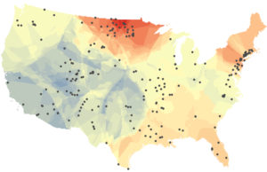
A new study released January 23, 2018 by University of Maryland researchers is the first to assess long-term changes in freshwater salinity and pH at the continental scale. Drawn from data recorded at 232 U.S. Geological Survey monitoring sites across the country over the past 50 years, the analysis shows significant increases in both salinization and alkalinization. The study results also suggest a close link between the two properties, with different salt compounds combining to do more damage than any one salt on its own.
This map shows changes in the salt content of fresh water in rivers and streams across the United States over the past half century. Warmer colors indicate increasing salinity while cooler colors indicate decreasing salinity. The black dots represent the 232 US Geological Survey monitoring sites that provided data for the University of Maryland study. Image credit: Ryan Utz/Chatham University.
The results of this “freshwater salinization syndrome”? Infrastructure corrosion, contaminant mobilization, variations in coastal ocean acidification caused by increasingly alkaline river inputs, and significant impacts on ecosystem services such as safe drinking water, contaminant retention, and biodiversity.
Simply put, fish and bugs that live in the Raritan River and our freshwater streams can’t survive in extra salty water. And while almost all of us in the Lower Raritan depend on local streams for drinking water, water treatment plants are not equipped to filter out the extra salt, so it ends up in tap water and corrodes pipes.
Road salt is everywhere during winter months. It keeps us safe on roads and sidewalks, but it can also pose a threat to fish and wildlife as well as human health. Of course we want to keep our roadways safe. We also must ensure that any salt spreading be conducted utilizing best practices for sustainable use, which includes calibrating salt spreading in accordance with weather forecasts and minimizing the amount of salt spread over sensitive habitats.
There are things you can do to help us better understand the impacts of road salt on our local environments. The Cary Institute of Ecosystem Studies presents several best management practices in their new report: “Road Salt: The Problem, The Solution, and How to Get There.” One key recommendation is identifying areas for low or no salt application. That is, basically creating a buffer of “no salt zones” around any water body. This report also identifies substitutes for road salt, and their relative impact on our waterways.
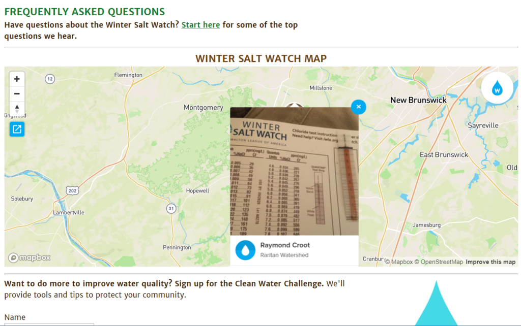
And the Izaak Walton League is recruiting volunteers to help measure salt levels in area streams to gauge the extent of salt spreading impact. With the information they gather they will be able to develop a targeted and prioritized approach to reduction of salts in local and national waters. The Izaak Walton League requires a simple registration process, after which participants receive a free chloride test kit. The kit includes test strips and instructions to measure the chloride level in local streams, then report out findings in a national database.
Dedicated Lower Raritan Watershed volunteer Raymond Croot is the first to submit “winter salt watch” data for a Lower Raritan stream.
On the second Monday of 2019, LRWP Board Member and Rutgers Professor David Tulloch welcomed me to his office at the Center for Remote Sensing and Spatial Analysis lab (CRSSA). Giant maps on the lab walls hint at what Professor Tulloch does at Rutgers. His research focuses on a mixture of landscape architecture and Geographic Information Systems (GIS). Professor Tulloch received a Bachelor’s degree in Landscape Architecture at the University of Kentucky, his Master’s in Landscape Architecture at Louisiana State University, and PhD in Land Resources at the University of Wisconsin, Madison. He has now lived and worked in the Lower Raritan Watershed for two decades. He enjoys exploring our area on foot, urban hikes, and trying to connect pieces of landscapes that a lot of people overlook. These interests led him to create an interactive google map that explores various features of the Lower Raritan Watershed. The map will soon be a supplement for Professor Tulloch’s “Watershed Highlights and Hidden Streams: Walking Tours of the Lower Raritan Watershed,” which kicks off on Sunday March 16.
LRWP Board Member, Professor David Tulloch
TaeHo Lee: Where are you from in the LRW, and in your time in the watershed, how have you engaged in/explored the watershed?
David Tulloch: I live in Highland Park near the Mill Brook, and I have lived there for nearly 20 years. I am within an easy walk to the Raritan making it hard to ignore the connection of the landscape and its watershed to the river. I’ve gotten to know the watershed as I explored it not only as a person who is curious about the large landscape. But also, as a benefit of my job, I have what amounts to two decades of mapping and design projects in different parts of the LRW and the larger Raritan River basin. Student research projects and studios have helped me get to know the watershed in ways that now are quite helpful in ways that, at the time, I didn’t always appreciate. My favorite thing to do in the Watershed is just to get out and walk it. I will look through historic maps or various air photos and look for hidden connections to explore. But there are also plenty of marked trails within the Watershed that I have yet to walk.
TL: As a parent, how do you want your kids to engage in/with the watershed?
DT: Well, I want my kids, like so many people who have grown up here, to really treasure this as a special landscape and see that it is both a special landscape and a singular, very large landscape. It has a fascinating history that we don’t talk enough about: American history, Revolutionary War, World War II, and an industrial history which is really significant as it impacted people around the world but also has impacted the river and our communities pretty dramatically. There are interesting educational and cultural histories for example, a colonial college right on the banks of the river in New Brunswick, the old proprietary house in Perth Amboy, the Monmouth Battlefield. So many things have marked this landscape. Additionally, its nature is incredible: Bald eagles, peregrine falcons, sandhill cranes, all within a few miles of us. And the landscapes that make up the Watershed are amazing: Mountains to marshes with really special spots within the Watershed like Duke Farms, Watchung Reservation, and the Rutgers Ecological Preserve. I really hope that my sons are coming to see the place not just as memorable but as incredibly special and something to treasure, even if they end up in another part of the world in the coming years.
TL. What, in your view, are the primary issues that need to be addressed in the watershed?
DT: The first for me is clearly the need to improve resident’s awareness of the Watershed and its issues, and their understanding of how both natural and policy processes within the Watershed work. I think one of the real challenges for us, an issue that affects ultimately the quality of water of the river, is encouraging our population of something like 800,000 residents to understand that the watershed is so much more than the river, and more than just the river valley. Most people associate the watershed with Donaldson Park, Johnson Park, Duke Island, or Duke Farms, and they can see those as areas that are associated with Raritan River. But we need to help them understand that in a 350 square mile watershed places like Freehold, Scotch Plains, and Bridgewater are all contributing to the water quality and the experiential quality of the watershed. And with a growing awareness and understanding, comes an appreciation of how much we still don’t know and how we need to enlarge our understanding of the river.
The other issue that
really stands out to me is the land use of the watershed. It covers 350 square
miles and includes 50 municipalities, each making their own independent decisions
about land use with very little coordination, and we share collectively in the good
and bad outcomes of these decisions. I live in one of those municipalities and
work in another, but in between projects for work or taking my kids to
different events I spend lots of time in other watershed towns experiencing the
results of those independent decisions made in 50 different borough halls, city
halls, and township halls. A really important step is to begin to monitor land
use choices, and to examine them in terms of how they impact the watershed. We
need to help the different people involved with the LRWP connect with those
processes and see them in a more serious way.
TL. What is your vision for the LRWP?
DT: One important thing as a young organization, part of the shared vision we all have, is that as a growing organization it needs to be nimble enough to adjust to not only the changing needs of the Watershed but also the changing understanding of what the organization can become. Through listening and learning and reshaping itself, we all come to a new understanding of what the Lower Raritan Watershed as a community, as a physical landscape, and as a place with changing pressures on it, is.
Having said that, three
areas are really important for us. One is appreciation. I don’t just mean that
in the broadest sense, not just appreciating the place, but appreciation based
on increased understanding. That’s getting more residents out on cleanups so
they can see the problems themselves; getting as much as we can out of the
research at Rutgers and the NJ DEP and from others working along the river so
that our appreciation of those problems are also based on something serious.
Second is advocacy. My
vision for LRWP sees it as a voice for the river and the Watershed that can
really advocate for needs that often don’t have a strong voice.
Third is action. Turning
the appreciation and advocacy into action. This includes small steps like
cleanups, but some of the actions we take overtime can become more dramatic. Appreciation,
advocacy and action, I think, together really represent a forward looking
vision for the Watershed and the Partnership that could engage a very large
number of residents and not just the usual suspects.
TL. You are a Professor at Rutgers. What is your role there? Can you provide insights into how we can best bring the resources and attention of the University to address the needs of the LRW?
DT: As a faculty member of Rutgers, I have formal roles. I am Associate Professor of Landscape Architecture, Associate Director at CRSSA, and lead the GeoHealth lab. A lot of the things that I do at Rutgers are as an integrator, as someone crossing over between different kinds of activities. So I work as an educator, and in landscape architecture I teach design, I teach planning, I teach what we call geomatics. But I’m also a researcher here at the center. We are looking a lot at the ways that the landscape is shaped and affects human health and our lives.
In my role as an
integrator, I bring research into the classroom, and draw students back into
the research. In the same way, I am now really interested in integrating the
experiences with the watershed into the different activities that I have in
Rutgers, as well. As part of my research 20 years ago or so, I visited and
interviewed NGOs all over New Jersey, looking at their use of GIS and mapping. The
groups that most caught my attention at the time were primarily watersheds.
Many of them were brand new and in that way, for me, it was the first chance to
learn and explore New Jersey’s landscapes. This forced me begin to confront the
potential that Watershed organizations have as advocates for pieces of the
landscape across municipal boundaries. I also began to see a role for
integrating science and education and policy.
One of the other roles
that I have at Rutgers is interacting with students. I get to know a lot of
students as they first come to Rutgers. A role for me with students who are not
from the area is helping them appreciate what a special place this is, getting
them hooked on the River, and sharing Rutgers’ long relationship with the river.
After all, it’s mentioned in the school song. In the broadest sense, to answer your
question, we are so fortunate as a watershed organization to have a University
like Rutgers in such an integral relationship with the river and the Watershed.
But, with the many research and outreach programs that Rutgers has, one of my
ongoing roles is going to be bridging the two and helping make connections with
those activities and helping be a voice for the Watershed as well.
TL. I understand you are planning a series of “Walks in the Watershed.” Can you tell me more about this opportunity? What is your goal with the walks?
DT: Part of this goes back to simply trying to help all of us improve our appreciation and understanding of the watershed in little and big ways. But the walks are a very special way to connect the abstract places that we’ve all seen on maps with very real experiences on the ground. The goal with the “Watershed Highlights and Hidden Streams: Walking Tours of the Lower Raritan Watershed” is to help reveal connections across landscapes of the Watershed that are often hidden in plain sight, but also to help us explore some connections, like hidden streams, that are truly invisible.
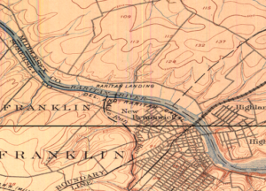
Johnson Park/Raritan Landing – 1890s
Over time we will try some walks that explore the outer edges of the Watershed – Beyond the banks of the old Raritan – but at the start, we’re going to take walks that explore connections of important pieces of land to the river and, where possible, look into the streams that make those connections. So, one of the first walks, on March 17, is going to be close to the Rutgers campus here where we’ll be looking at the connections between Buell Brook and the Raritan by taking a walk that connects Johnson Park and some of its history and Raritan Landing with the Eco Preserve. Many people visit Rutgers’ Eco Preserve and don’t think, even when they are only hundreds of yards away from the river, don’t think of its connection to the river. The walks will look more at the connection and what it means. Walking also just reveals some other patterns and some hidden features along the way. I hope to be as surprised as the other participants. A second walk this Spring, scheduled for May 18, connects the old constructed landscapes of the canal at Duke Island County Park through a new greenway that has been developed along the Raritan and crosses over into the Duke Farms properties. I think a lot of the residents in that area are familiar with individual pieces. Fewer have made the walk to connect them all. We hope to make the walks a regular experience.
TL. Is there anything else you want to add?
DT: When you asked about what I do at Rutgers and how this helps make connections for the watershed, let me mention one more example. I think that as I teach planning students and geomatics students and design students who make some connection with the place, that the Watershed as a whole also is benefiting from those who stay here. An interesting example of that is Daryl Krasnuk, who I taught as an undergraduate student. Daryl has continued to volunteer and make maps both for the LRWP’s general education efforts and specifically for the State of the Lower Raritan Watershed report. It’s exciting to see the students that I taught now sharing their passion for this special place and finding ways to help up us to improve that landscape over time.
Martin Luther King Day was established as a National Holiday in 1983. Eleven years later in 1994, Congress added a service component to the holiday. Monday January 21 marks the 25th anniversary of our federally designated National Day of Service, also called the “King Day of Service” or “A Day On, Not a Day Off.”
Through his leadership of the civil rights movement, Dr. Martin Luther King provided tremendous service to our nation. Despite this, media coverage of the service aspect of Martin Luther King Day celebrations is sparse. Especially rare are stories that highlight impacts of volunteering that go beyond economic valuation and personal benefits.
How can we build on Dr. King’s legacy and celebrate volunteering in ways that strengthen our neighborhoods and nation? We can conceive of service as an expression of citizenship, service as an expression of generosity, and service as the opportunity to experience a felt sense of community.
Citizenship. The pressures of our day-to-day political and economic engagement tend to reduce us to “voters” or “consumers.” Through this process we lose sense of ourselves as citizens, and lose connection to our communities. Volunteering allows us to connect deeply with one another as citizens in the craft of working together for the common good.
Generosity. Non-profits, schools and nursing homes do not need “free labor” or “spare time” as much as they need the generosity of spirit that prompts us to engage as volunteers. In sharing our generosity, we are held to a higher standard: the intention to enhance the true well-being of those to whom our generosity is given.
Community. Volunteering is about a felt sense of community. It is about making connections and building resilience. Connections, resilience – these are especially critical assets in these more trying times.
As we recognize 25 years of celebrating service as a national value, let’s reflect on and commit to grow through the broad benefits of volunteerism. Evolving through service in this way can help strengthen our diverse communities and further protect civil rights and civil liberties.
Heather Fenyk, Ph.D. serves as Board President of the 100% volunteer-run Lower Raritan Watershed Partnership based in New Brunswick, NJ.
The Lower Raritan Watershed Partnership is often asked to talk about the most pressing environmental issues facing our Central Jersey watershed communities. Here is our “Top 10” list of cross-cutting concerns for 2019. Starting in February we will feature one concern a month on our website, exploring that issue (and potential solutions) in more detail. We invite you to join in the conversation.
Poorly coordinated stormwater management, conducted at municipal (not watershed) scales, means that one community’s flood control efforts can lead to another community’s flooding problems.
Perceptions of safety (poor lighting, litter) around riverfront spaces, and poor signage and access to these spaces, deters use and enjoyment of our waterways. If we don’t know our rivers and streams we won’t grow to love them and act to protect them.
Failure of aging water infrastructure (culverts, pipes, inlets and outfalls), an urgent safety issue for all our communities, is exacerbated by an increase in precipitation due to climate change.
Poor control of non-point pollution sources (fertilizers and pesticides from lawns, sediments from development and erosion, oil and grease and road salt from roadways, animal and human waste, dumping of detergents and paints and other chemicals into stormdrains, and litter) results in high chemical levels, bacteria loads and algal blooms in our rivers and streams.
State and regional authorities do not have a clear plan to improve knowledge of the health of the Raritan and its tributaries, and do not model pollutant loads for our watershed.
Recent federal rollbacks of requirements for oil and gas reporting may result in increased methane emissions and open the door to more pipelines that fragment and threaten habitat.
Federal policies that extend the offshore fishing season and increase allowances in catch rates for commercial fishing reduce numbers of anadromous migratory fish in the Raritan, affecting the food chain.
Check with your local Environmental Commission or Green Team for information about specific source impacts and development pressures in your community.
Article and Photos by Margo Persin, Rutgers Environmental Steward
Editor’s Note: In 2018 Margo Persin joined the Rutgers Environmental Steward program for training in the important environmental issues affecting New Jersey. Program participants are trained to tackle local environmental problems through a service project. As part of Margo’s service project she chose to conduct assessments of a local stream for a year, and to provide the data she gathered to the Lower Raritan Watershed Partnership (LRWP). Margo keeps a journal of her experiences, excerpts of which are included in the LRWP’s “Voices of the Watershed” column.
As my year-long project entailing the assessment of the Ambrose Brook is now drawing to a close, I wanted to make one last observational visit to the site, which I completed on 31 December 2018. As I was driving over, in my mind I reviewed the year and wondered, at this point in the process, if there would anything more or new that I could possibly say about the Ambrose Brook. Well, was I in for a surprise, and a most captivating one at that! I arrived at just about 10:30 am, I was the only human around, and as I traversed the eastern side of the stream, I spied just one pair of mallards afloat on the lazy, meandering brook. The male’s plumage was blatantly obvious against the muddy, slow-moving current, whereas the female’s was camouflaged just about perfectly with the background: muddy water, brown earth, fallen leaves. The sky was overcast and the air was calm with a moderate 40 degree temperature that provided a welcome and silent capsule for my period of observation. My goal was to walk the bank, if possible on both sides, from a bit past the small waterfall all the way back to the footbridge and back again. And with this trajectory, nature provided me with a series of surprises.
As
I made my way south on the eastern side of the brook, a veritable flock of
mallard pairs came into view, comfortably resting on the water’s surface, the
first that I have seen in the entire year.
They gave me a slight if sneering glance, then turned away from me to
glide closer to the western bank. Secondly, as I walked along the bank farther
and farther from the street noise, I noticed that several trees had a
distinctive series of marks along the base up to about one foot, all around the
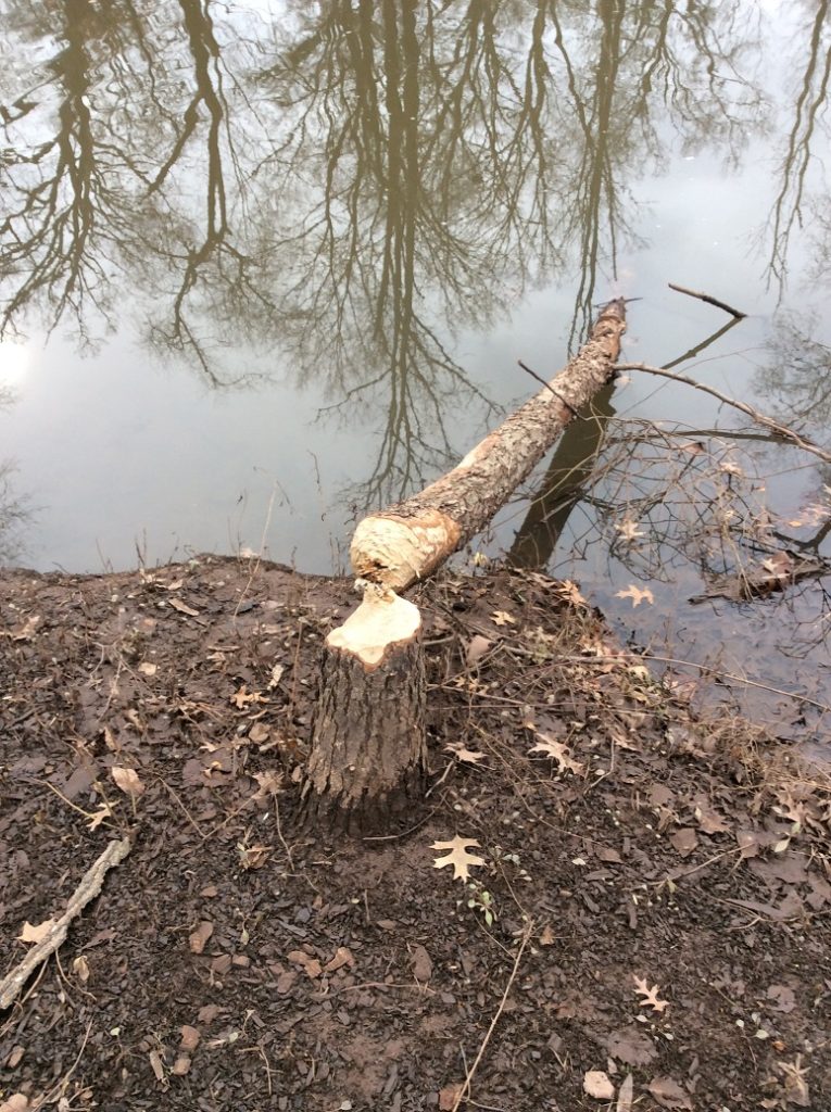
circumference of the trunk. I am not a
naturalist, but I wondered if by any chance it could be a family of beavers at
work. “Nah”, I said to myself, this
place has too many people around, “no way”.
Well, I suspect that I was proved wrong!
At another spot, a neatly chewed tree, gnawed to what looked like a
precise pencil point, had been felled and now was lying in the water, the
severed trunk just inches from the sad looking stump. “Aha!” I exclaimed, “nature wins again,
beavers’ resourcefulness as effective or more so as a mini-chainsaw”. I never did see any beavers but their handiwork
was a very good indicator of their presence.
At the farthest point away from the street, still on the eastern side of
the brook, felled trees were piled up very close to the water’s edge, and I
wondered whether that might be an indication of a lovely and cozy den. Hmmmm…..
Beaver handiwork. Very impressive!
After
crossing the footbridge to the western side of the brook, I was presented with
another of nature’s surprises. Now that
winter is officially upon us and foliage has died back both above my head and
below my feet, I was able to make my way about three quarters of the distance
to the small waterfall. As I walked
among the brown brush, fallen branches, and dormant grasses, it dawned on me
that the brook had on this western bank a lovely and wide flood plain well
below street level that I had never noticed before, given the presence of a
daunting array of vegetation, including some very fierce brambles that had
heartily discouraged my passage in previous visits. Wow!
Talk about hiding in plain sight!
I presume that this flood plain accepts the surplus of storm water that
occasionally overflows the banks of the brook, which is then absorbed into the
ecosystem, but in turn does not flood area streets … or basements. Nifty!
West Bank flood plain, Brook is to the right, street to the left.
And two last affirmative surprises. Having crossed over once again to the eastern side, I noticed yet another storm water outlet that fed into the brook, close to the small waterfall. I had never noticed it before because of the verdant camouflage offered by the grasses that were presumably fed by its generous flow and overflow. It was right there all the time, but I had never seen it. It humbled me and made me smile – in this visit, I suspect that nature, anthropomorphized to be sure, was having a good chuckle at my expense because of my naiveté. To think that there would be ‘nothing more to see’ was pure hubris and I was given my comeuppance. In addition, the waterfall also had a surprise. Even though the water continues to flow, it was evident that it was starting to freeze at the base! The clumps of white ice shone unmistakably through the tumbling current, a solemn reminder that winter is upon us. I would have missed it if I had not walked closer to the waterfall than I had ever done on previous visits.
Waterfall view in winter. Great for a contemplative moment.
The
last surprise was not a very happy one.
As I made my way on both sides of the brook, I took note of several
places where the water was almost completely stagnant, where the current did
not have the opportunity to lend an active, cleansing presence. And in those small culverts at the water’s edge,
I noted that the water kept a glaze of oil slick of who knows what
composition. At first glance I had
guessed that the water might be beginning to freeze, but upon closer
inspection, the real reason for the discoloration was obvious: water pollution
of a chemical nature. Ugh.
So this was my visit, a combination
of wonder and despair. I plan to offer
in the coming weeks one last report, an estimation of the year’s trajectory as
applied to my original proposal for this project. Happy New Year, everyone! May nature be your guide and live in your
heart.