Article by LRWP Streamkeeper Coordinator, Jon Dugan
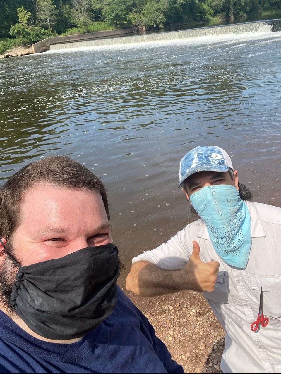
In this month’s volunteer spotlight, we are going to learn a little bit about the Ambrose Brook and one of its volunteer Streamkeepers, Mike Vacca.
Ambrose Brook Streamkeeper Mike Vacca on the left, with LRWP Streamkeeper Coordinator Jon Dugan
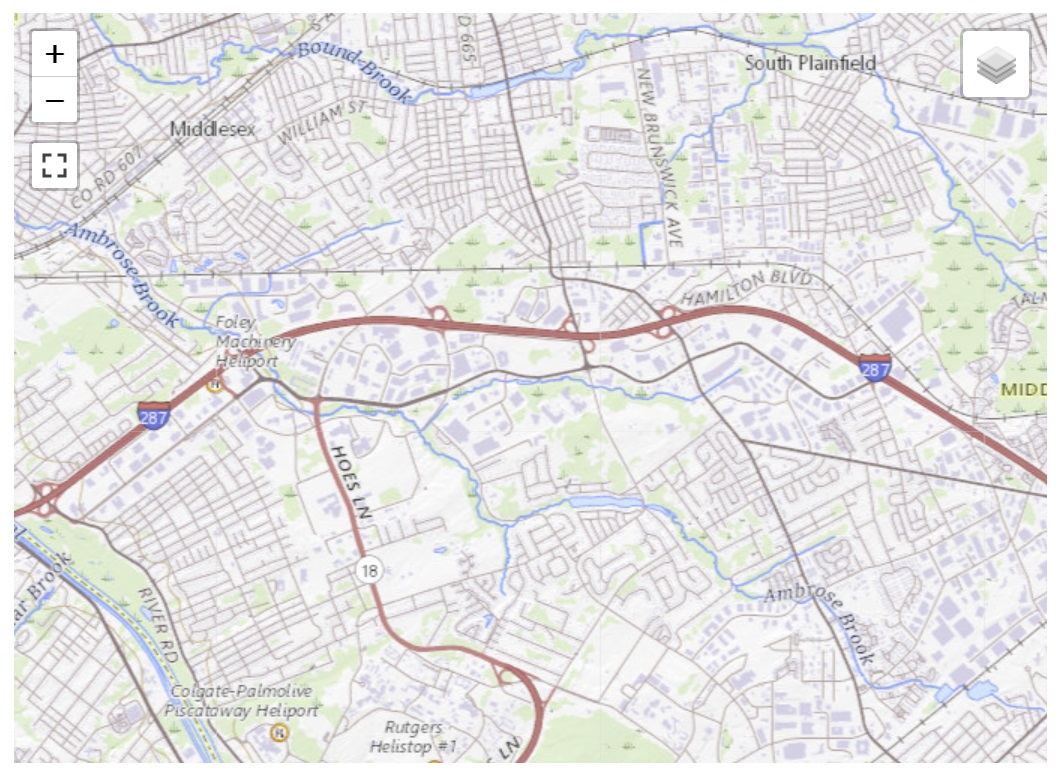
Ambrose Brook is a tributary of the Green Brook in Middlesex County, New Jersey in the United States. The Ambrose originates underneath what is now a Volkswagen dealership along Route 27 in Edison. It then flows into Lake Papaianni, which is within an Edison Twp. municipal park. The Ambrose then continues flowing northwest, parallel to County Route 529, eventually crossing Route 529 and Ethel Road West, it forms a border to some businesses in Piscataway.
Upon flowing into Lake Nelson, the brook takes a more westerly route into Ambrose Doty’s Park. The brook then takes a southwest turn and flows into the Green Brook near Lincoln Boulevard in Middlesex just before the Raritan River. During this entire course of flow, the LRWP monitors two key locations along the Ambrose Brook, selected for the location to their confluence.
Mike Vacca is one of the Streamkeepers for the two sites along the Ambrose Brook before it connects with the Green Brook. Mike started his volunteer days with the LRWP back in May 2019, where he started learning about the Visual Monitoring Program. He volunteers for the Spring and Fall session on monitoring, and often will attend workshops to sharpen his habitat-assessing skills. Mike takes measurements and graded-evaluations of the stream in order to give it an overall Habitat Assessment score. These scores are compared with prior years to “paint a picture” of the stream health of the course of several years.
When Mike is not out monitoring the Ambrose, his interests are gardening, hiking, movies, music, painting, video games, and spending time with his nieces. Mike also likes collecting glass and interesting looking rocks (especially ones that he finds when walking up and down the river or hiking). Keep an eye out for him the next time you find yourself in the Ambrose Brook watershed!
A fox sparrow takes refuge from a late March snowstorm as it migrates north to its breeding grounds
The fluffy white blanket of an early March snowstorm, preserved by the cold days that followed, began to shrink as the sun fought the darkness for dominance. The snow cover was still unbroken as it grudgingly settled lower each passing day. Eventually the white blanket would lose its loft and become threadbare, unveiling the gravid brown earth.
The days following the storm dawned clear and cloudless. The night sky was a showcase of brilliant white diamonds, alive with energy as they sparkled in the infinite celestial darkness.
An hour before sunrise the west facing snow covered hillside reflected enough light to reveal the fine detail of the skeletal silhouettes of every tree and bush that stood above the white ground cover. Even as the sky began to brighten, the entire hillside remained in shade, preserving the dramatic pre-dawn contrast. For a few slow minutes, the sky above the hill was bathed in a diffuse aura of gold, fading into white, which blended into the palest blue, growing more intense as the brightest stars lingered and were lost among the deepening blue background. For a long moment, night and day, past and present coexisted at one glance. The dynamic scene, frozen on an imaginary vertical tapestry, the black and white hillside held in sharp contrast to the gold and sunlit blue sky above.
In a way, that dawn was symbolic of the dichotomy of March, as the month ushers in the last cold breath of winter and departs amid life emerging from dormancy under the influence of increasing daylength.
Maroon, orange, green, and red buds decorate the bare tree branches to rival fall color, as early spring flowers tolerate the mercurial weather and defiantly poke through any errant late Match snowfall.
Bird migration is now in full swing as flycatchers, osprey, and colorful warblers make their appearance.
Great horned owls, hatched a month earlier, are flightless and near adult size.
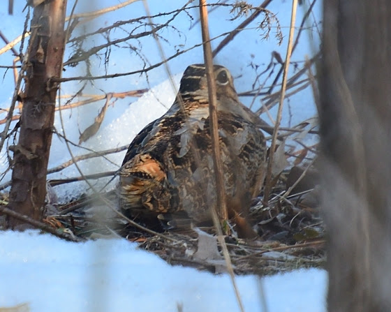
March is the best time to find migrating woodcock and observe the unique mating flights performed by the males at dusk, choreographed to impress a potential mate. Woodcock were common locally in open woods and damp fields. As habitat dwindles, any sighting becomes a rare treat. When March rolls around I head for a likely spot where a swale is formed by the earlier mentioned hillside. The hillside is drained by a seasonal stream which remains wet where the gradient levels. The saturated soil creates a perfect environment for earthworms, the main food source for migrating woodcock. Woodcock, also known as Timberdoodles, will often sit tight and allow a close approach.
All migrating birds must deal with unpredictable weather anywhere along their migration path. So, arrival at any one location will vary from year to year. It is somehow comforting when birds that migrate through, show up on schedule. All is right with the world. When snow buntings, headed to points north, stop over at a specific location year after year, a dependence of sort can develop on behalf of the observer. The snowbirds become a reference point, much as a birthday or anniversary.
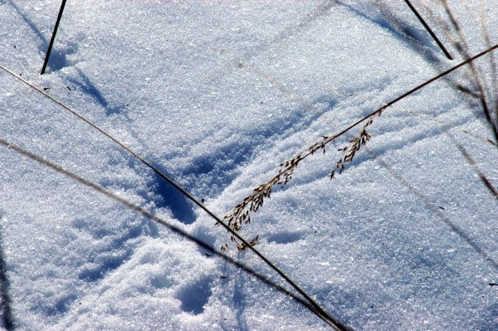
March provides the ‘wind beneath the wings’ of migrating birds as well as sweeps the land and grooms the trees, wind and March are inseparable.
March has earned the reputation as the month of relentless wind as it rushes mercurial weather on and off the stage to stir the breeze. Think about the wind and the scale of expression from hurricanes and tornadoes to a gentle whisper, where the wind uses a dried stem of grass or tree branch to etch its thoughts in the snow or on the side of an old wooden barn.
The first day of spring will happen on the nineteenth day of March, 2024, at 11: 06 pm. Day and night reach perfect equilibrium for a split second as winter surrenders to spring.
Author Joe Mish has been running wild in New Jersey since childhood when he found ways to escape his mother’s watchful eyes. He continues to trek the swamps, rivers and thickets seeking to share, with the residents and visitors, all of the state’s natural beauty hidden within full view. To read more of his writing and view more of his gorgeous photographs visit Winter Bear Rising, his wordpress blog. Joe’s series “Nature on the Raritan, Hidden in Plain View” runs monthly as part of the LRWP “Voices of the Watershed” series. Writing and photos used with permission from the author.
Essay and photos (except as noted) by author Joe Mish
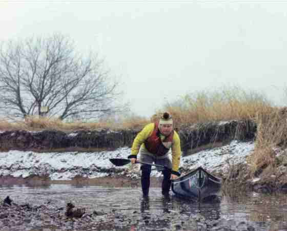
Not on par with Shackleton’s adventure, the intent of this winter paddle trip was to see what nature is doing when she thinks no one is watching. Self portrait
Sleepy eyes involuntarily shut to set the stage for transient dreams to vie for recollection in morning’s foggy consciousness, as a mid-winter storm promised a night of undecided precipitation.
The view through the frosted bedroom window at dawn, revealed the storm’s final decision in the form of powdery snow, preserved by an overcast sky and sub-freezing temperature.
First light of dawn appeared as a proxy of the sun who farmed out delivery of a mere fragment of daylight intended to last the day.
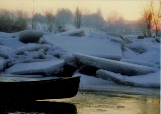
A long spell of cold had locked the river in ice and curtailed any thought of canoeing. A heavy rain followed to raise the water level and break up the ice. The water settled down to a suitable flow, and I was anxious to see the aftermath and capture some wildlife images in between winter’s extreme mood swings.
Predawn light reveals broken slabs of ice, thrown asunder, by swollen water from a heavy rain, followed by a dusting of powdery snow. Moody winter weather is the rule.
The air was still and not a breeze stirred, a sure sign of snow to come. The conditions were perfect, as light snow was expected about halfway through the trip, and it would add mood to any landscape or wildlife images. Wildlife tends to feel more secure and reluctant to move in sub-freezing temperatures, allowing a close approach.
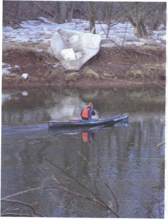
View from the canoe. Digital evidence here, though so many more incredible moments in nature are retained only in the form of recoverable memories altered by time, instead of digital editing.
The camera lens is less likely to get blurred in the absence of wind-blown precipitation. If a stiff breeze was predicted, I would never launch my canoe. Wind is the rate limiting step for my winter sojourns, along with safe water levels. Safety is critical and is weighed against any cold weather canoe trip.
I placed the boat in the quiet water along the shore, just inside the edge of the current. I carefully settled into the center seat, holding the carbon fiber paddle across my lap. Out of habit, I always wait a moment after engaging with the current to feel the enthusiasm of the river’s energy to partner with my energy infused paddle strokes.
Are you sure you want to go canoeing? Photo by Mary Ellen Hill.
There can be several distinct reasons to make a downriver run on any given day, all dependent on mood, weather, and water flow. The intent of this winter paddle was to see what nature is doing when she thinks no one is watching.
Digital evidence is nice to have, but not as essential as just being present to experience what cannot otherwise be seen and felt in tamer conditions.
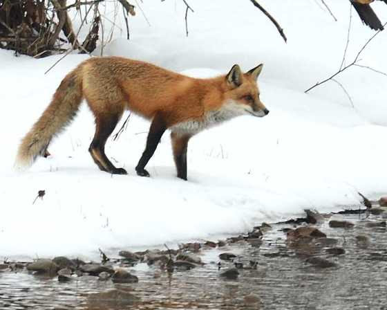
The female red fox hiding behind the branch along the shoreline is a trigger for the behavior that followed and not digitally captured. She looked directly at me while she moved off, and defiantly stopped in the open and still staring back at me, squatted to pee
The current is my guide, as my hull is directed to follow its winding course worn into the hard shale riverbed, especially critical at lower water levels.
Ice out! open water, adventure awaits! Image of me taken without my knowledge, by Bill Haduch. Never know what you might see on the river.
I generally use a hit and switch style of paddling where the boat is kept on course by alternate stokes instead of turning the paddle blade at the end of the stroke, which is grossly inefficient, as it slows hull speed. Though, any paddle stoke in the nick of time is the correct choice.
As I switched sides after each series of strokes, the water dripping off the paddle blade fell on the ash gunnels and instantly froze. Fine drops quickly freeze and after layers of ice accumulate, its collective weight and height above the water, moved the center of gravity forward to make the hull plow left or right with each stroke and reduce stability. An occasional pause was required to clear the gunnels of ice, using the paddle’s sharp edge to shatter the ice.
Clearing the ice was not an existential crisis and at times I would use a north woods style paddle stoke in deep water, where all paddling is done on a chosen side, never lifting the paddle from the water. This is a useful stroke when drifting up on unaware wildlife as paddling motion is restricted to the offside and the stroke, completely silent.
As I neared home pasture, a light but steady snow began to fall straight down. This was the time to allow the river’s energy to take control one last time, set aside my physical presence and exist for a meditative moment in conscious stillness. A brief side trip, compliment of the water’s endless energy.
The carry from the river through the pasture to home had its own reward. I have a pair of pile lined, heavy wool mittens stowed in a zip lock bag, reserved just for this occasion.
I rarely wear gloves when paddling in cold weather, though when I take out, stow my pack and paddles, lift the hull on my shoulders, my hands get wet and cold from the water collected in the hull. It is an anticipated treat to wear those mittens on the portage home. As I slipped on the mittens, I noticed a single flake of snow caught on an errant strand of wool, its unique structure designed as if by intelligent hand. This was the essence of a mid-winter canoe trip, ephemeral moments in nature, stored in memory for instant retrieval, to be enjoyed and shared. It was just the icing on the gunnels.
Author Joe Mish has been running wild in New Jersey since childhood when he found ways to escape his mother’s watchful eyes. He continues to trek the swamps, rivers and thickets seeking to share, with the residents and visitors, all of the state’s natural beauty hidden within full view. To read more of his writing and view more of his gorgeous photographs visit Winter Bear Rising, his wordpress blog. Joe’s series “Nature on the Raritan, Hidden in Plain View” runs monthly as part of the LRWP “Voices of the Watershed” series. Writing and photos used with permission from the author.
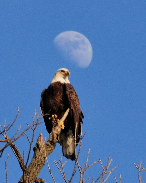
The rebirth of the Raritan River is symbolized by a waxing moon hovering above a Bald Eagle, perched along the river, teeming with ancient fisheries, whose recovery is a result of recent dam removals. A birthstone to define the Raritan River as an entity removes its status as a documented enigma and affords it the respect and honor it deserves.
The Raritan River is the longest river that flows within NJ, its rich, pre and post-colonial history well documented in archives and books. Surprisingly, its location has confused state and federal authorities who have mislabeled the North and South Branch of the Raritan River as the Raritan River. Signs on interstate 78 in Clinton identify the South Branch as the Raritan River. Further east on I-78 the North Branch is designated at the Raritan River. State road 202 at the border of Branchburg and Bridgewater claim the North Branch of the Raritan River as the Raritan River.
Last of the cast irons signs which correctly identify the North Branch of the Raritan River. I know of only two other cast irons signs, long gone, which marked the course of the South Branch and Raritan River proper.
To further muddy the waters of the Raritan, an online search of the River’s length will show anywhere from 69.60 to 115 miles. Imagine, a defined measurement of a major river’s length cannot be established! For the record, based on my two canoe trips down the entire Raritan River, I estimate its length at 33 miles. Given the margin of error, 33 miles referenced against the lowest published estimate of 69.60 miles, creates more of an enigma than a reality.
To bring the Raritan River in focus from an enigma, and accord the respect it deserves, it must be properly defined and labeled. Once the river’s identity is established, a gravitational pull of curiosity arises and compels a quest for more information. A better understanding of the river’s role in its watershed and the community it supports can provide critical perspective needed to make sound land and water management decisions.
The first step in establishing respect, whether a person or a river, is to know their name. It is innate in our nature to respond kindlier when a name is offered upon introduction. Consider a hiker walking across a field, free of obstruction, the path will be a straight line. Point out a single species of grass, and the hiker will alter their path to avoid stepping on the now identifiable plant.
Toward that end, an effort is underway to define the beginning of the Raritan River with a boulder placed at the confluence of its north and south branches. A bronze plaque will be attached and petroglyphs carved into the boulder to memorialize native animals and first people.
This indelible marker will, in a way, serve as a birth certificate in the form of a ‘birthstone’ to legitimize the Raritan River proper.
“Raritan River Birthstone” (DRAFT for plaque) “This stone marks the beginning of the
Raritan River and defines this natural treasure as an entity. The Raritan River’s legacy of beauty, inspiration and use, has nurtured all life since its post glacial formation. Arising from the confluence of its north and south branches, the Raritan River begins its thirty-three mile journey to the sea. The petroglyphs carved into this stone represent wildlife and symbols of the Unami, a branch of the Lenape tribe, which would have been seen in glyphs carved by the earliest people”. “Dedicated by the Lower Raritan Watershed Partnership 2023.”
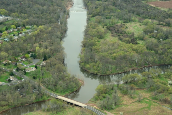
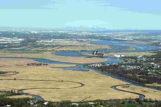
Placement of the ‘birthstone’ and the location of the Headgate dam at the very top center of the image.Image taken on flight compliment of LightHawk and No Water No Life.
In 2023’s Raritan River, dolphins and seals ply the waters up to New Brunswick, while young Hudson Bay striped bass and alewives make their way up river to Bound Brook. As dams are removed and historic fisheries revitalized, the Raritan River is in a way reborn and deserving of a ‘birthstone’ to finally mark it place of birth.
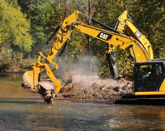
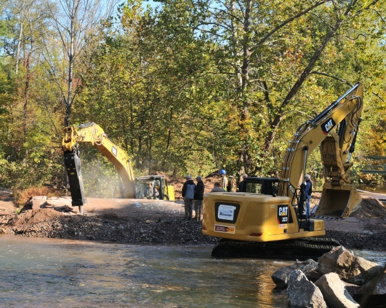
The Burnt Mills dam on the Laminton River which flows into the North Branch and eventually into the Raritan river was removed in 2020.
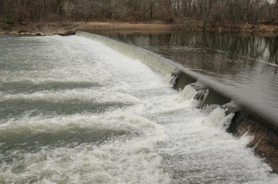
The Headgate dam on the Raritan River, built in 1842, is scheduled for removal. This dam is located a few hundred yards below the beginning of the Raritan River at the confluence of the North and South Branch. The hydraulic created by the dam has caused several deaths over the years.
Author Joe Mish has been running wild in New Jersey since childhood when he found ways to escape his mother’s watchful eyes. He continues to trek the swamps, rivers and thickets seeking to share, with the residents and visitors, all of the state’s natural beauty hidden within full view. To read more of his writing and view more of his gorgeous photographs visit Winter Bear Rising, his wordpress blog. Joe’s series “Nature on the Raritan, Hidden in Plain View” runs monthly as part of the LRWP “Voices of the Watershed” series. Writing and photos used with permission from the author. Contact jjmish57@msn.com.
Imagine a colorful fleet of canoes and kayaks gathered at the confluence of the north and south branch in anticipation of the start of a dash down the Raritan River to the sea. Described as a sojourn, dash, race and tour to accommodate all levels of experience, the finish lines for each class can be a different take out along the way. Classes for racers, timed for placement and simply celebration upon reaching any chosen finish line for the touring dashers. Distance or time become the personal feedback for participants who may wish to improve their last year’s performance. In that way the ‘race’ has the elements of developing into a tradition where dad’s and daughters, moms and sons, look forward to next year and maybe in anticipation, focus on improving their health and physical conditioning.
The paddler’s intimacy with the Raritan brings with it a deeper appreciation of the river, which has existed as more of a concept to most people who may only glimpse it at a distance, while passing over a bridge on the way to work. With intimacy comes consideration and concern about all things impacting the river and its watershed.
The possibilities to grow a network of support for the treasure that is the Raritan River, are limited only by imagination. Photographs and art work inspired by the river’s appearance through the seasons could be celebrated by riverside towns, restaurants, schools and galleries to be dispersed far and wide. Like seeds in the wind, the beauty and appreciation of the Raritan may be an inspiration to awaken distant communities to the riverine treasures in their backyard.
One example of a successful effort to market a once polluted river, is the Kenduskeag Stream Canoe Race, held each April, in Maine. At one time salmon and eels returned from the sea via the Penobscot River to the Kenduskeag stream. By the time Thoreau walked he shores of the Kenduskeag in the mid 19th century, tanneries and flour mills blocked and poisoned the stream and continued well into the 1960s. A group of local canoeists came up with the idea for a canoe race to showcase the Kenduskeag and bring attention to its health. Eventually the race expanded to be televised and enjoyed by hundreds of viewers and attendees. The salmon run is making a comeback and even Sports Illustrated found room on its cover to celebrate the longest early season canoe race in New England. I participated in this race for eighteen years and carried the seeds of inspiration back to the Raritan. It is no small coincidence that Henry David Thoreau left indelible footprints along the Raritan River and the Kenduskeag for future generations to follow.
The crowd of streamside supporters bundled dry and warm, cheer on canoeists who await the countdown for the start of the Kenduskeag Stream Race. The countdown to the start of the race, 5. 4. 3. 2. 1.gets the adrenaline flowing. This is a scenario that may someday be played out at the confluence of the Raritan River.
Author Joe Mish has been running wild in New Jersey since childhood when he found ways to escape his mother’s watchful eyes. He continues to trek the swamps, rivers and thickets seeking to share, with the residents and visitors, all of the state’s natural beauty hidden within full view. To read more of his writing and view more of his gorgeous photographs visit Winter Bear Rising, his wordpress blog. Joe’s series “Nature on the Raritan, Hidden in Plain View” runs monthly as part of the LRWP “Voices of the Watershed” series. Writing and photos used with permission from the author. Contact jjmish57@msn.com.
On February 24, 2022 the Lower Raritan Watershed Partnership, Princeton Hydro and Middlesex County Office of Planning hosted a Virtual Outreach Session to share concept plan development for the restoration of a 165-acre coastal eco-park along the South River in New Jersey.
During this webinar project partners discuss ecosystem restoration; contextualize the site and its historic and current conditions; provide drone images of the site; and discuss proposed public access opportunities, recreational priorities, ecological enhancement (including identifying optimal nest platform locations for Osprey, Bald Eagles, and Peregrine Falcons), and more.
This project is supported through a $249,639 in National Fish and Wildlife Foundation grant to:
“Conduct an ecosystem restoration site assessment and design for 165 acres of tidal marshes and transitional forest in New Jersey’s Raritan River Watershed. Project will result in an engineering plan with a permit-ready design to reduce coastal inundation and erosion along about 2.5 miles of shoreline for neighboring flood-prone communities and enhance breeding and foraging habitat for 10 state-listed threatened and endangered avian species.”
During one, six thousand year moment, in the eons of glacial expansion and retreat, the Queen of Rivers was born. So described by an early nineteenth century writer, inspired by the bucolic Raritan River. The beauty of the river’s pastural floodplain dotted with colorful native flowers and grasses, stood in contrast to the intermittent high, red shale cliffs. Spring floods scrubbed the red shale soil from its banks to turn the raging river into a semi solid crimson torrent. The contrast in color is dramatic where gravel lined upland streams tumble into the main river current.
From sweet water freshet to the brackish tide water of its bay, the Raritan’s unimpeded flow expressed its seasonal moods in uninhibited water-colored brush strokes across the landscape, as if it were a living canvas.
So, the Raritan River proper, as it is defined today, deserves the recognition of a natural wonder, a reference point in geological history, worthy of attention in a state marked by an ever changing manmade landscape.
The Raritan’s headwaters arise from two major sources in the north, the South Branch from Budd Lake, and the North Branch from a swamp in Chester. The confluence of these two rivers join (in Branchburg) to form the Raritan River.
Facing upstream at the confluence, the river on the left enters from the south and is so named the South Branch, despite its origin in the north. The river on the right comes in from the north and is aptly named the North Branch.
If ever a natural wonder needed to be celebrated it would be the Raritan River. Toward that end I always imagined a rough stone marker of an age befitting the river queen’s origin be placed at the confluence, “the meeting place of waters”, Tuck-ramma-hacking”. Informal and primitive to match the uninhibited behavior of this ancient watercourse, a perfect partner to mark the celebrated river’s place of birth: a monument that will be submerged during spring floods and bear the scars of ice flows.
I imagine a bronze plaque bearing the name of the river and its birthdate set among petroglyphs of animal tracks and wild flowers carved into the stone by local artists to represent the community the river serves.
The spot for eventual placement of a “birthplace of the Raritan” marker
Bringing a dream to reality often turns to fantasy. At least now an attempt is being made to explore the possibility of placing such a stone at the apex of the North and South Branch Rivers. Through a network of well-placed friends, we have approached the state with this request to determine feasibility. A labyrinth of permits and permissions remains to be navigated if given conditional approval. At the very least, the ship has left the dock and we will soon learn if it is seaworthy.
A stone, not yet chosen, has been promised and placement will be included. The river deserves to have a name and birthstone. Erroneously, the North Branch has official signage that declares it to be the Raritan River. If nothing else, it would be a worthy accomplishment to establish the correct identity.
“Like a pine tree linin’ the windin’ road, I’ve got a name, I’ve got a name…..” go the lyrics to a song. What is in a name is respect. It is our nature to treat anonymity differently than familiarity. Walk through a field, not knowing one plant from another, go from point A to point B and we naturally take a straight-line course. Eyes planted on the far side, anything in the way gets stepped upon. Guarantee that if a plant is identified to the trekker, whether it be fleabane or little bluestem, the path will be adjusted to avoid stepping on the now identified plant. So it is with names that emerge from anonymity, they project some kindred link that brings conscious thought to bear. A good reason to identify the Queen of Rivers and engender some new found respect for a natural wonder that will be here after we and our kin are long gone.
Author Joe Mish has been running wild in New Jersey since childhood when he found ways to escape his mother’s watchful eyes. He continues to trek the swamps, rivers and thickets seeking to share, with the residents and visitors, all of the state’s natural beauty hidden within full view. To read more of his writing and view more of his gorgeous photographs visit Winter Bear Rising, his wordpress blog. Joe’s series “Nature on the Raritan, Hidden in Plain View” runs monthly as part of the LRWP “Voices of the Watershed” series. Writing and photos used with permission from the author. Contact jjmish57@msn.com.
Science writer Cheryl Lyn Dybas features the Raritan River and the dam removal work of Hydrogeologist John Jengo in her article “Birds Follow Flyways, Fish Navigate Swimways” published this week in the journal BioScience. Ms. Dybas also highlights research by Rutgers biologists Olaf Jensen and Anthony Vastano, who track the impact of dam removal on local fish populations in the Raritan, and cites additional research by Rutgers ecologist Julie Lockwood who is using eDNA (environmental DNA) to monitor the comeback of river herring and American shad in the Raritan. Cool stuff!
Ms. Dybas’ piece provides a fascinating global perspective on habitat connectivity, and contextualizes our local-to-the Raritan dam removal and fish passage efforts in a larger movement to save migratory fish species (World Fish Migration Day is May 21, 2022). We are so grateful for her attention and reporting on this work!
An elephant is like a tree, No! an elephant is like a snake, No! an elephant is like a wall. So claimed the three of the six blind men from Indostan, when they were asked to describe an elephant. In this case their blindness is representative of a loss of perspective and in that way, reflects on our nature to define the world into segmented parcels.
Being gravity bound to the earth provides a limited view and so, it makes sense to parse the world via man made contractions. For instance, take a local county road, built to traverse through several counties, towns and cities. To ensure continuity it was given a numeric designation. County route 514 is an example. However, as it crosses geopolitical borders it gets christened with a local name. Amwell Road, Hamilton Boulevard, Woodbridge Avenue and Main Street, etcetera, collectively are the same road, county route 514.
It is human nature to tease out pieces of the whole to better grasp an extensive subject. Our education system has honed specialization of studies to create unique disciplines and professions, each treated as unrelated kin.
Over time we have lost perspective of the whole and dismantled the larger puzzle into its component pieces, forgetting that all disciples are related and taken together, are additive and complementary. Formal education has handed each disciple of its hallowed halls a critical piece of the puzzle. Much like a treasure hunt, where a map is torn into pieces and handed out to individuals to ensure all participants must bring their scraps of paper together to find the hidden gold.
When we look at rivers, our earth bound position shapes our view. We see the north branch of a river apart from the south branch, each stream that feeds into a larger waterway gets a name. As a watercourse passes a political jurisdiction, that flow of water may, in some unusual cases, get a name change, not unlike our numbered county routes. Trace a stream back to its source and discover it doesn’t get a name on a map until it crosses a roadway.
I had the opportunity at the invitation of No Water No Life founder Alison Jones to accompany her and Lower Raritan Watershed Partnership president, Dr Heather Fenyk on a complimentary flight provided by LightHawk to photograph the entire Raritan watershed from its two main sources all the way to Raritan Bay and Sandy Hook.
The transition from a ground dweller to eagle was as breathtaking as it was revealing. Instead of only seeing puzzle pieces, the entire picture of the watershed miraculously appeared. Each segment lost its defined edges as the resolution increased; as if going from a pixilated image to a crystal clear picture.
Though intimately familiar with each section of the river, I was lost when asked where we were at any given moment. I tried to rely on referencing the last known position but the speed at which we travelled, and the new cloud high perspective was surprisingly disorienting. It takes about an hour and ten minutes to drive to Sandy Hook from the point of the confluence of the Raritan and its main branches, it took only a few minutes to fly there. That alteration of time and distance also serves to overcome the linear relationship of diminishing interest over increasing distance, a lingering, innate human survival mechanism focused on serving the moment to save the day.
The value of gaining a new perspective, where the threads reveal the weave of the cloth, provided an avenue for a holistic approach to temper human impact on the watershed as an entity. A change to any geo-politically defined segment must now be considered as systemic rather than an isolated local impact. Impervious surfaces increase upstream from housing developments and parking lots to flush more water into the river and exacerbate extreme weather flooding. Crops planted in the flood plain right to the edge of the river, cause erosion and silt build up to force flood waters further from the main river course.
A good lesson to remember is the literary relationship of the word river to rivalry. The word for people drinking from the same stream or river was rival in French and rivalis in Latin. When a downstream village’s drinking water was contaminated by the village upstream, it created a rivalry. Even in early times, the wisdom of what flows downstream was well ingrained in riverine communities, a lesson somewhat lost today.
In lieu of boarding a plane, fire up your imagination. Imagination is a magic carpet that transcends available opportunity, bad weather and poor visibility to deliver needed perspective. Imagine if you can the water in the entire Raritan River watershed replaced with blue injection molded latex as a giant hand reaches down and grabs the main trunk of the Raritan River, pulls it from the earth, and holds it aloft as if it were a giant oak tree, its crown represented by the ocean. The fine mass of hairy threads leading into primary roots and finally forming a main trunk. See the river as a tree, its form and function more similar than different.
A River’s watershed or tree, both a conduit for flowing water, perhaps an alternative way to grasp the concept of the extent of a watershed. Overlay this image on a land map to visualize a watershed, whose dimensions are typically presented in incomprehensible numeric values. Original artwork by Richard Reo
Loss of perspective is a demon that transcends all issues and stunts efficient problem solving, leads to false conclusions, lost time, and energy.
Perspective may be gained in several creative ways, though it takes imagination and an open mind to intellectually take flight to see the whole picture. Once we realize our world is one entity and the smallest change has a cascading effect far downstream beyond where we figured the ripples terminated, we are better prepared to approach business, technology, relationships, education and nature while promoting the sage advice of ‘first do no harm”.
New York City as seen from the lower Raritan river begs a hand to reach out and touch it, as opposed to driving for hours on congested toll roads and across bridges. When distance and time reduced, it brings a new perspective and increased interest. Flight compliment of LightHawk and No Water, No Life.
Author Joe Mish has been running wild in New Jersey since childhood when he found ways to escape his mother’s watchful eyes. He continues to trek the swamps, rivers and thickets seeking to share, with the residents and visitors, all of the state’s natural beauty hidden within full view. To read more of his writing and view more of his gorgeous photographs visit Winter Bear Rising, his wordpress blog. Joe’s series “Nature on the Raritan, Hidden in Plain View” runs monthly as part of the LRWP “Voices of the Watershed” series. Writing and photos used with permission from the author. Contact jjmish57@msn.com.
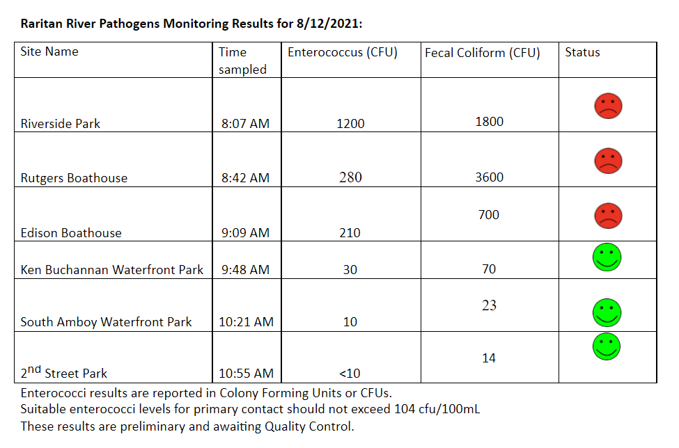
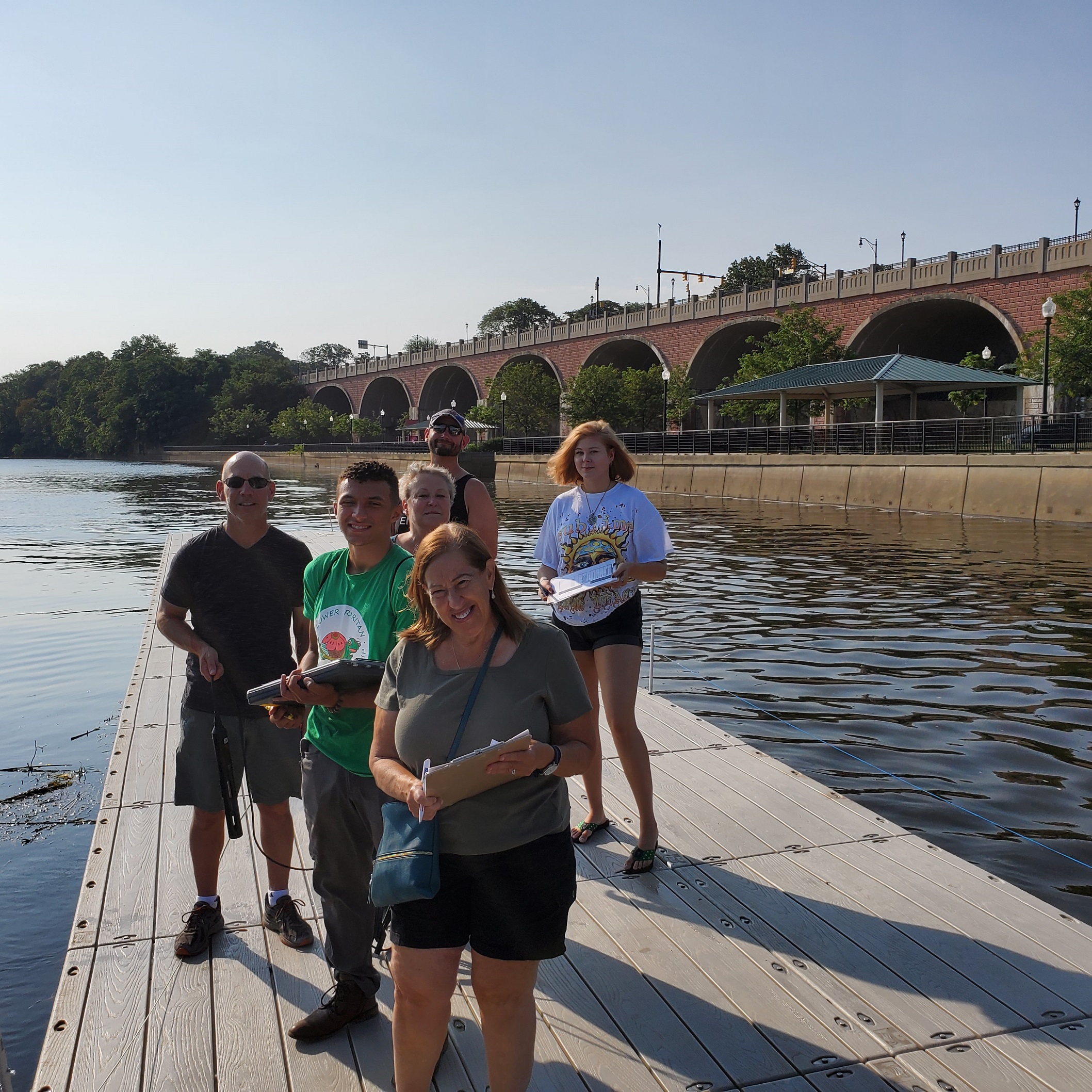
The Lower Raritan Watershed Partnership and Rutgers Cooperative Extension of Middlesex County run a volunteer pathogens monitoring program from May to September every Summer. On Thursdays we collect water quality samples at 6 non-bathing public access beaches along the Raritan River, and report out the results on Friday afternoons. Our results for 8.12.2021 are a mixed bag. Numbers for the upstream sites (Riverside Park, Rutgers Boathouse, and Edison Boathouse) are high, whereas downstream toward the Raritan Bay the numbers improve (Ken Buchanan Waterfront Park, South Amboy Waterfront Park, Perth Amboy’s 2nd Street Park). As always, if you choose to recreate on the water this weekend, stay safe, and be sure to wash your hands! See here for more information on our pathogens monitoring program.
A few additional things to share:
#1 Holy smokes was it a hot day for monitoring yesterday! If you are out in this crazy heat, stay hydrated!
#2: LRWP volunteers and friends are AMAZING!!
Gratitude to: Dorina Cardinale, Janet Sacklow, Jason Acevedo, Andrew Gehman and Maya Fenyk for sampling yesterday. And special thanks to Jesse Stratowski with Rutgers Recreation for opening things up at the boathouse for us!
Thanks also to LRWP Water Quality Outreach Project Coordinator Jocelyn Palomino and Rutgers Environmental Stewards Program Steward Julisa Collado (and her father Jose) for coordinating a fun youth outreach event at our last stop in Perth Amboy.
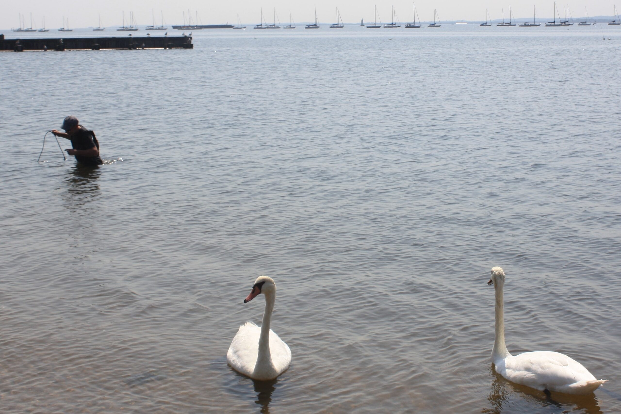
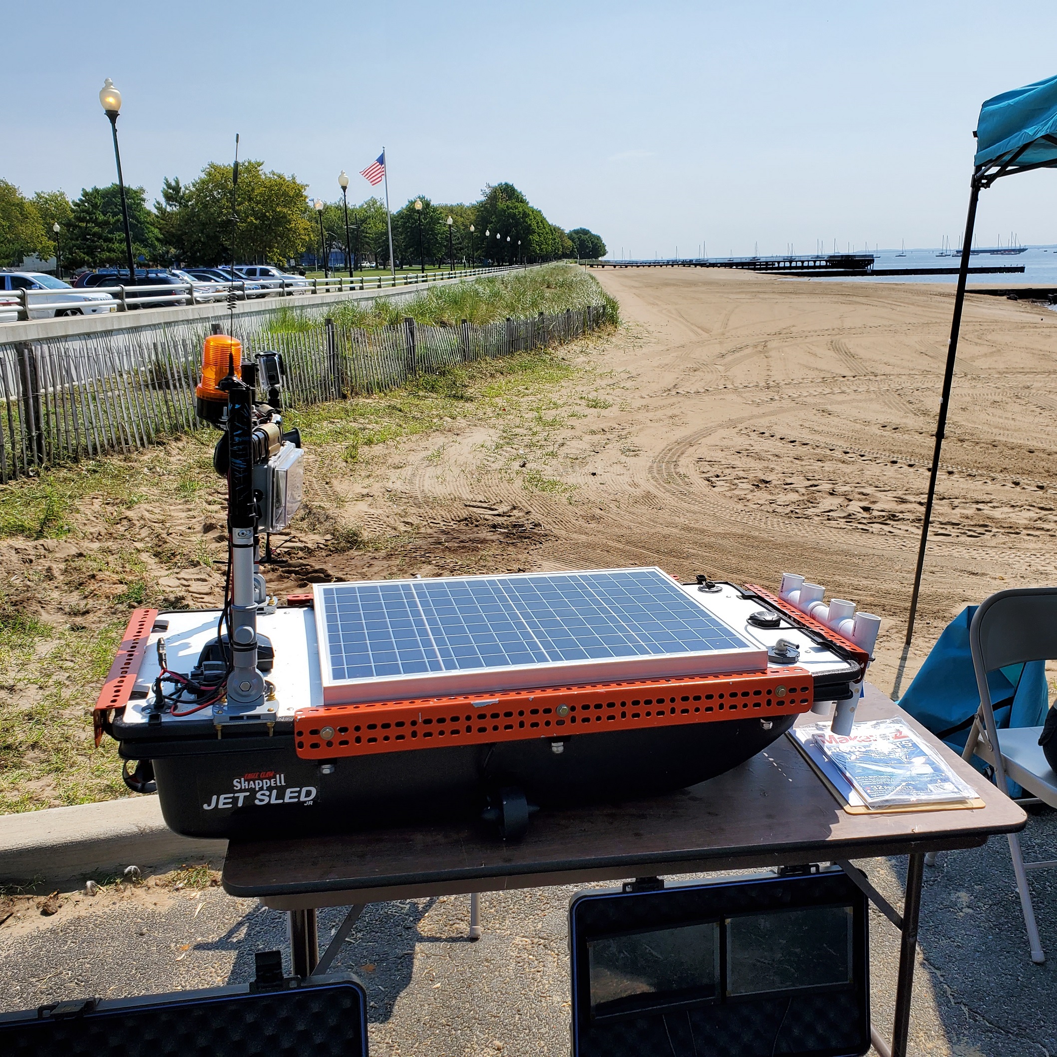
We enjoyed catching up with friends who joined us for outreach: a pair of white swans, Elizabeth Pyshnik with Rutgers Cooperative Extension Water Resources Program, Renee Skelton with Perth Amboy SWIM, Raritan Riverkeepers Bill Schultz & Lorraine McCartney, and Michael DuFour with Sky Horse Tech LLC who brought the very cool “water drone” prototype, designed for in-channel sampling (see photos).