Article by Franklin Township resident Anna Merrett, photos by LRWP Board Member Heather Fenyk and NJ Water’s Mitch Mickley. For tools and guidelines for implementing Green Infrastructure and low impact design in your communities, see the Environmental Protection Agency’s Non-Point Source Pollution webpage, which includes the Bioretention Design Handbook, published by their Nonpoint Source Management Branch. The handbook was developed to inform practitioners about the latest approaches and lessons learned for bioretention design, construction, inspection, and operation and maintenance.
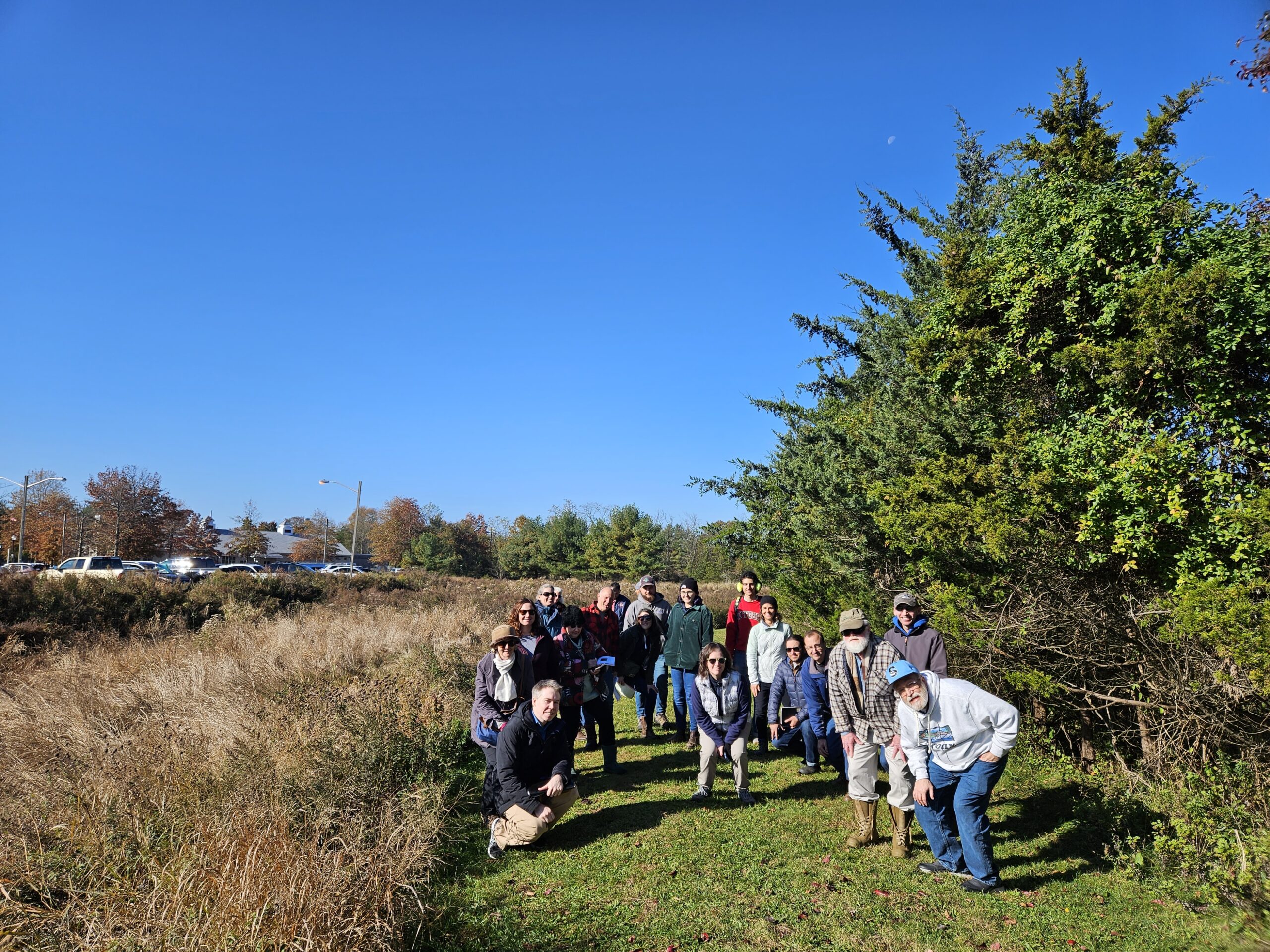
On Friday, November 3rd, Kathy Hale, Principal Watershed Protection Specialist for NJ Water Supply Authority (NJWSA), led a field trip to four out of five retrofitted stormwater basins in Franklin Township, Somerset County. The outing was organized and sponsored by the Lower Raritan Watershed Partnership. Twenty participants, including members of municipalities, representatives from state departments, the Highlands Commission, engineering firms, academia and Environmental Stewards took part in the field trip. A smaller group ended the day with lunch at Stage House Tavern, where lively discussions followed.
Located in the Franklin Township Municipal Complex, on Gaugin Way, Renoir Way, Dellwood Lane and Laird Terrace, the stormwater basins are owned by the Township and mainly receive residential runoff. Franklin Township mapped their stormwater infrastructure ahead of most other municipalities. Township staff worked with NJWSA to select these five basins for retrofit based on size, location, visibility, and structure. The main goal of the retrofits is to slow water runoff and lengthen the water flow path, helping decrease the amount of sediment flowing into the Delaware and Raritan Canal and other local waterways. Increased sediment in stormwater runoff leads to the need for additional treatment by water supply purveyors.
Mitch Mickley, who shared this drone footage, shared that the drone was flown during a drought, and makes the stormwater basin at Renoir Way, Franklin Township (NJ) “look like a green oasis in a sea of dry dead lawns.”
NJWSA’s Kathy Hale explained the background for the basin retrofit in greater detail:
“NJ Water Supply Authority, created in 1981, is an independent state agency. Our main role is to manage water supply in Central New Jersey, so we manage Spruce Run Reservoir, Round Valley Reservoir and the Delaware and Raritan Canal as drinking water supplies that provide water to about 1.5 million people in Central New Jersey. We also manage Manasquan Reservoir, where we provide a supply for around 600,000 service connections in Monmouth County. NJWSA doesn’t treat water, but provides untreated water to the water purveyors, who then treat and distribute it. At Manasquan Reservoir we do have a small water treatment plant which provides water under contract to a few municipalities. Our main role is to maintain the quantity of water that flows to our water purveyors, including: NJ American Water Company, Middlesex Water, North Brunswick, New Brunswick and the municipalities in the Manasquan System. Our customers understand that it is less expensive to keep pollutants out of the water rather than remove them.
The Delaware and Raritan Canal is a 65-mile water supply facility that transfers water from the Delaware Basin to the Raritan Basin. Data and field observations show that turbidity does not decrease in the last 11 miles of the Delaware and Raritan Canal, indicating that settling solids are replaced by sediment from influent streams and stormwater discharges.
Traditional stormwater basins have a concrete low flow channel designed to move water through as fast as possible. Traditional stormwater basins are also typically planted with turf grass, which does not aid water quality treatment or drainage into the ground. Many stormwater basins are fairly compacted when it comes to the soil, which does not help with infiltration. The turf grass tends to encourage nuisance species such as geese and it has high maintenance cost.
We worked with the Township and identified several basins, which we prioritized, and chose four to be retrofitted. A fifth basin was added later in the project. Princeton Hydro provided design services for the project. Three of the basins are within the Cedar Grove Brook watershed, one of the largest drainage areas to the Canal. A fourth basin drains into Six Mile Run and the fifth basin drains into the Canal through another tributary. Funding for the project was provided by NJDEP and the Delaware and Raritan Canal Commission.”
Our group carpooled to the basins, where we walked around the basins, allowing for a closer examination of the retrofits.
Carl Hauck, the Manager of Franklin Township Public Works and the Township Stormwater Coordinator, explained the maintenance plans for the retrofitted basins: The township inspects the basins following every major storm, regularly checks for trash, removes sediment, and mows the basin meadow just once or twice a year. Previously, the basins were mowed every week during the high growth summer months.
Our group poses next to the stormwater basin at the Franklin Township Municipal Building
The new vegetation, consisting of native wildflowers, requires minimal upkeep, significantly lowering the overall maintenance cost, noise levels and energy usage. Planted wildflowers attract birds, pollinators, and other wildlife, and deter the geese. The upgraded vegetation with its deep roots, helps filter out pollutants and lets the stormwater runoff soak gradually and directly into the soil. The concrete channels for water runoff have been replaced by naturally meandering waterways, greatly slowing down the water flow. Berms, forebays and scour holes were built into the inlet structure to further slow down the runoff.
“At each of the basins, the bottoms were rototilled to reduce compaction and the soil was supplemented with compost. Basins are designed to drain within 72 hours, in part to prevent mosquito breeding.” At one of the basins, an underdrain was also added to facilitate water movement.
NJWSA reached out to the five stormwater basins’ neighbors holding zoom meetings and sending postcards explaining the necessity of the retrofit. Some homeowners did not find the look of the retrofitted basins visually appealing, preferring the traditional lawns.
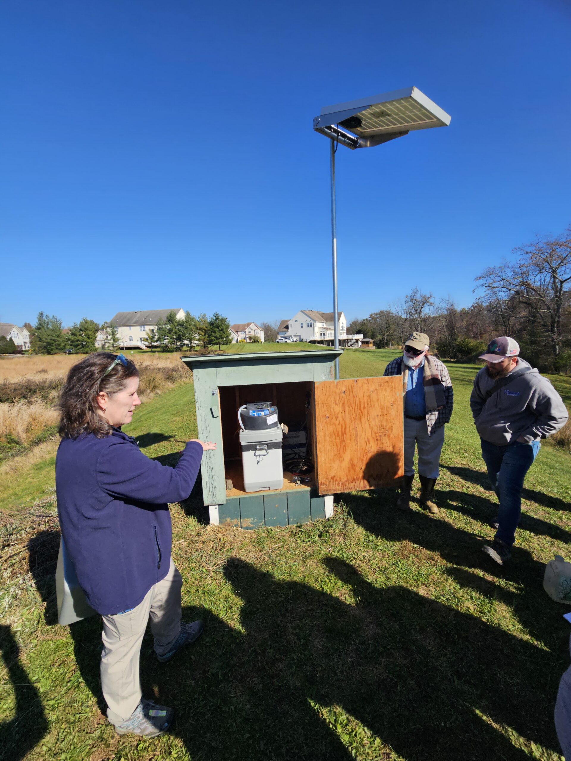
NJWSA has conducted visual and vegetation monitoring. In addition, they are conducting pre and post construction water quality monitoring at two basins.
Kathy Hale explains how water quality samples are captured at this site.
Heather Fenyk notes: “The Lower Raritan Watershed Partnership offers multiple workshops and field trips annually to support municipalities and local community members to better understand local hydrology and best practices for watershed-friendly stormwater management. The November 3rd tour of Franklin Township’s retention basin retrofits was specifically organized as part of the LRWP’s MS4 Municipal Stormwater Management Assistance Program, through which we partner with municipalities to customize watershed-friendly stormwater outreach and education programs to help them meet federally mandated stormwater management requirements under the Clean Water Act. We invited Kathy Hale to share the wonderful work that Franklin Township and the Authority have done locally so that other municipalities in the area could get a soup-to-nuts understanding of what it takes to install these beautiful, watershed-friendly, River-friendly, drinking-water-friendly projects. We would love to see dozens of naturalized stormwater basins throughout the Lower Raritan!”
On Thursday October 12 the Lower Raritan Watershed Partnership will host Paul Kenney from NPS to talk about Partnership Wild & Scenic designation for the Raritan River. Please join us for this discussion from 10am to noon at the Middlesex County Administration Building, in the first floor Commissioner’s Meeting Room (75 Bayard Street / New Brunswick).
About Partnership Wild & Scenic Rivers Designation:
Congress has specified in some Wild and Scenic River designations, that rivers are to be administered by the Secretary of the Interior through the National Parks Service in partnership with local governments, councils, watershed groups and non-governmental organizations, generally through the use of cooperative agreements. In these ‘Partnership’ Wild and Scenic Rivers communities protect their own outstanding rivers and river-related resources through a collaborative approach.
Partnership Wild and Scenic Rivers are a unique category of designated rivers managed through long-term partnerships between the National Park Service and community, local, regional, and state stakeholders.
Editor’s note: The LRWP views engagement in the arts and humanities as integral to the work of effective science communication. In the article below long time partner coLAB Arts Director of Education John P. Keller articulates aspects of our ongoing collaborative inquiry into these processes, reflects on the importance of reciprocal relationships between art and science, and poses challenging questions to guide us in further discovery and expression.
Article and photos by coLAB Arts Director of Education John P. Keller
…the most extraordinary work happening today is work that considers: How does the creative studio space expand research? And how does scientific inquiry make art better?
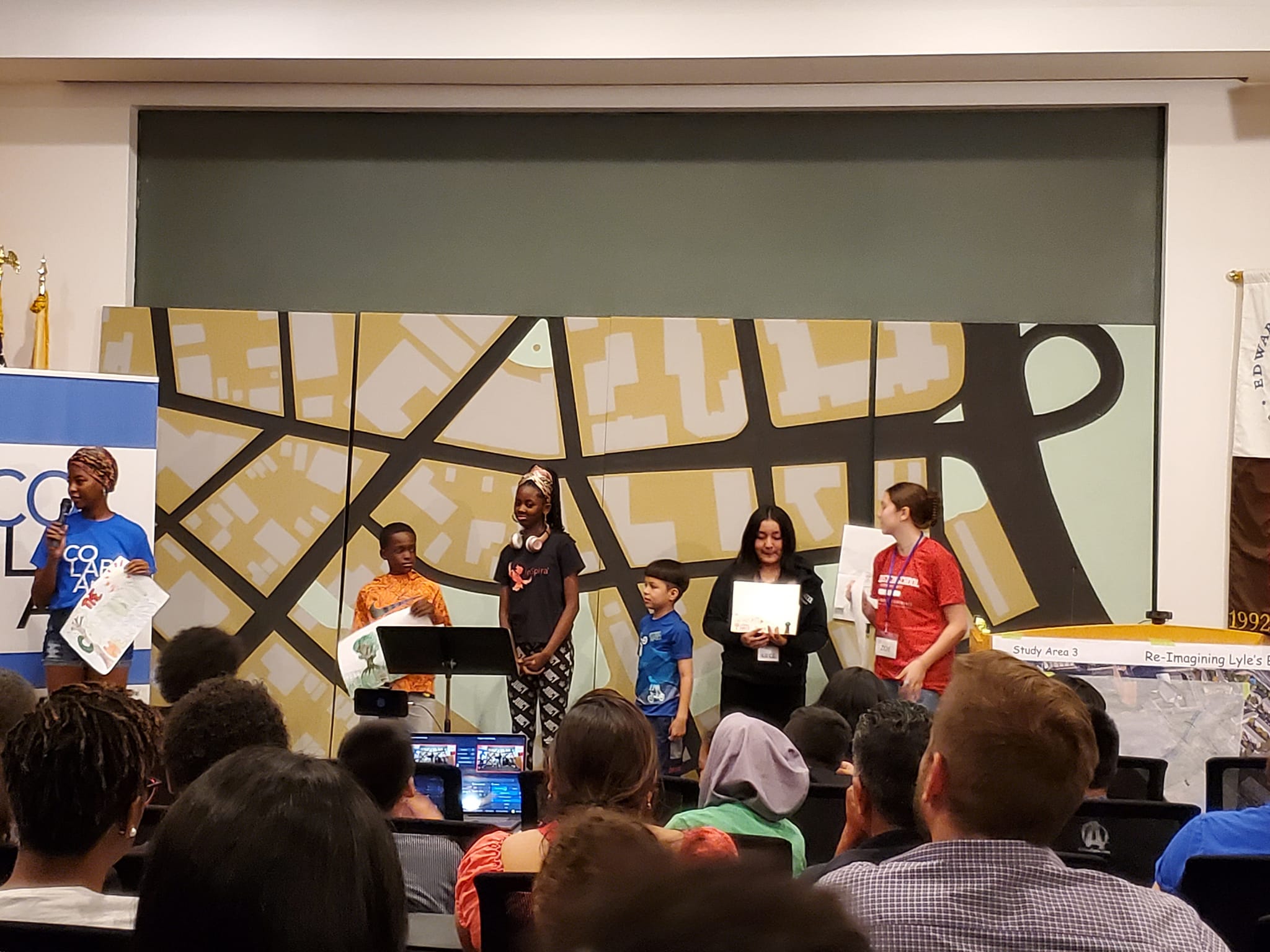
On a hot and humid August afternoon in the coLAB Arts educational studio, Teaching Artist Jasmine Carmichael was giving final rehearsal instructions to 60 summer institute students: “We are going to start from the top, if something is a little off just keep going and trust the ensemble, and remember… you are water.”
Students were “knee deep” in the process of devising a dance piece reflecting their knowledge of water flows through ensemble based movement. Thanks to the Lower Raritan Watershed Partnership and Rock Dance Collective, these students married an emerging science-based understanding of the natural world with an arts-based embodiment of the human experience. In other words, they were using both their brains and their bodies to more deeply connect with the concept of water and our relationship to it.
“…remember… you are water.”
Leonardo DaVinci would not have understood the concept of a division between scientific reasoning and creative expression. The observation of water speed, velocity, and turbidity would have been interwoven with the processes of creating sketches with shading, patterning, and composition. Hypothesis would have not been possible without imagination. Good storytelling would not have been possible without data. Human truth would not be transferable from one person to another without reflecting objective scientific realities framed in metaphor. Yet somehow over the course of the centuries and the development of institutions we think of scientific reasoning and creative expression as two very different pursuits, dividing both their physical proximity (the studio vs. the lab) and their emotional (literal vs. figurative or fact vs. fiction).
Leonardo DaVinci Water Study
c. 1508-9. Wikimedia Commons
There are of course exceptions that live outside the sometimes restrictive academic divisions. In fact most methodology-based artists and most humanist-scientists already understand the mutual benefit. So why aren’t our institutions designed to enable better collaboration? What would such a redesign of the creative and scientific process look like? What could this redesign of process mean for the tackling of climate change? The Artists and Scientists mentioned above might articulate two main areas of mutual benefit, that of interchangeable: 1) Research and 2) Expression. In my own education growing up, whether it was explicit or inferred, I always thought the idea of research belonged squarely to the scientist. Articulation on the other hand belonged to the studio artist. However, the most extraordinary work happening today is work that considers: How does the creative studio space expand research? And how do analytic metrics make art better?
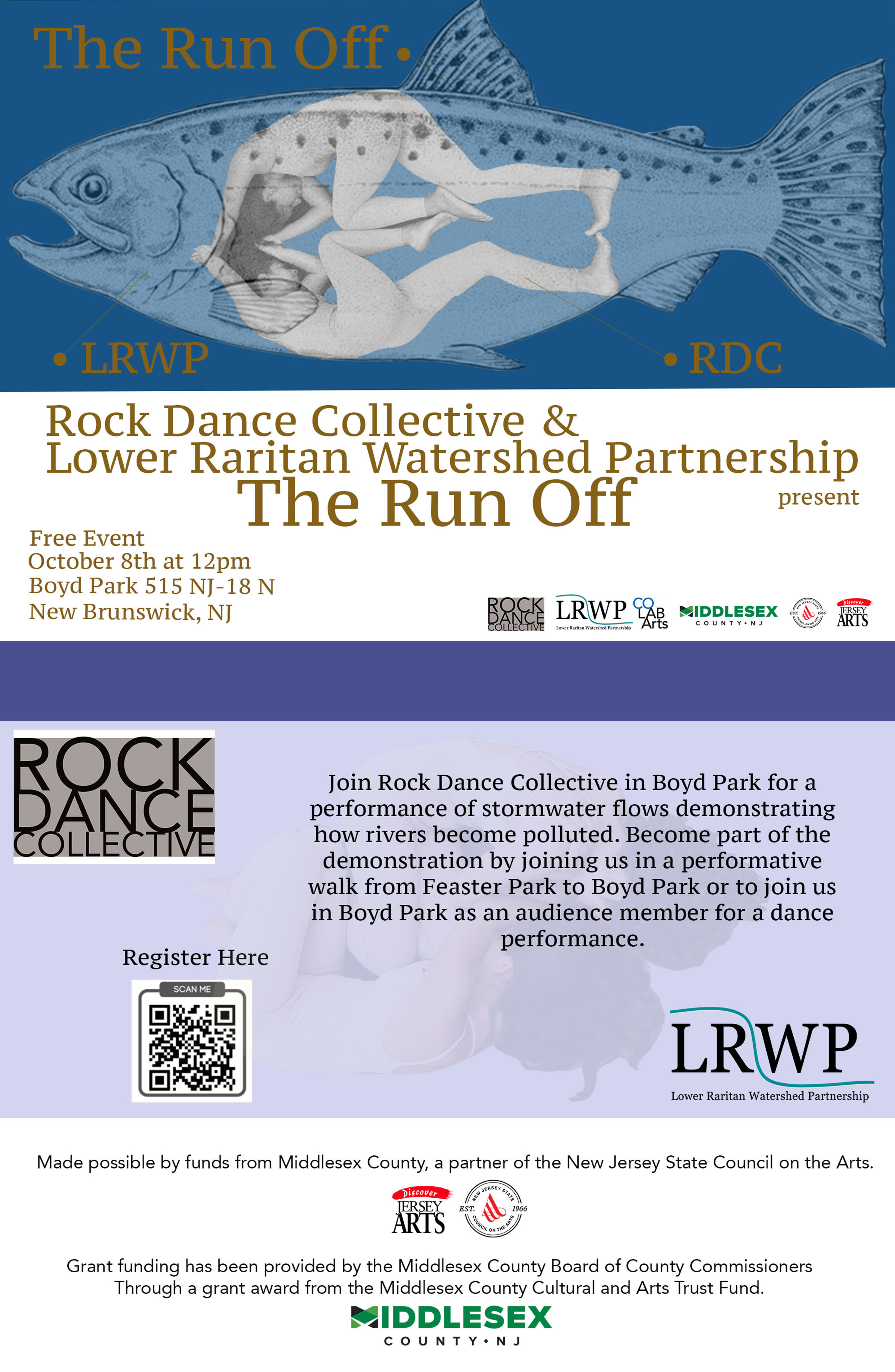
In preparing for the October 8th Watershed Run Off – a dance performance of stormwater flows to demonstrate how waters become polluted — the partnership of Rock Dance Collective, the Lower Raritan Watershed Partnership and and others started with creative word play as a way to investigate the cultural connection with water. Building on this they layered data, metrics, observation and hypothesis in the studio to create an embodied expression. Lower Raritan Watershed Partnership is putting artists out into the field, taking advantage of new ways of seeing, and feeling, to influence scientific methods. Other local entities like the Rutgers University School of Environmental and Biological Sciences and Mason Gross School of the Arts are also developing nascent partnerships to create new interdisciplinary methodologies and curricula, actively reimagining the dividing lines of the academy.
Over the next year coLAB Arts and Lower Raritan Watershed Partnership will continue putting artists and science educators in rooms (and floodplains!) together to expand the work of each. And we aim to support deeper inquiry and conversation within our communities. Consider our October 8 “Watershed Run Off” as the first of many opportunities for all members of the watershed to directly nurture and experience the evolving field of art and science collaboration. Join us!
Jasmine Carmichael (far left) leads Summer Institute students in explaining how they created the large map (behind them) of New Brunswick streets and “hidden” streams.
Join the LRWP and Rock Dance Collective in New Brunswick at noon on Sunday October 8 for a performance of stormwater flows, demonstrating how rivers become polluted.
With thanks to our wonderful coLAB Arts partners for making magic on the theme of #hiddenstreams and watershed health. For six weeks in Summer 2023 we are working with coLAB Arts to lead area youth in creatively imagining resilient futures for our central NJ landscape.
Weeks 4-6 final presentation will be held Friday August 25, 1pm in New Brunswick’s Joyce Kilmer Park.
Summer Institute 2023: Youth visions for New Brunswick’s Lyell’s Brook Final presentation at Rutgers’ Bloustein School for Planning & Policy
The Lower Raritan Watershed Partnership is pleased to present our 2022 Annual Report! With special thanks to Rutgers Raritan Scholar Chris McLaughlin for his assistance in developing this document during Spring semester 2023.
Swimming or other forms of contact with contaminated water can cause gastrointestinal illness as well as respiratory disease, ear and eye infection, and skin rash. Each year, there are an estimated 57 million cases of illness in the U.S. resulting from swimming in oceans, lakes, rivers and ponds. The vast majority of these illnesses go unreported.
Contaminated water can also trigger health warnings or closures that interfere with our ability to enjoy public bathing beaches. Around the country, for those public bathing beaches that are part of the Environmental Protection Agency’s Beach Advisory and Closing On-line Notification (BEACON) Program, there were more than 8,700 health warnings or closures in 2022.
Significant sources of pathogen pollution that can make swimmers, fishers, boaters, jet-skiers or others sick include stormwater runoff, sewage overflows and in some places, manure from livestock.
Two trends have increased the pollution risk in New Jersey from these sources:
Development. The addition of impervious surfaces – such as warehouses, big box retail landscapes, parking lots and roads — increases the flow of polluted stormwater into our streams, brooks, and rivers, and coastal waters. Paving over wetlands or forests that had once absorbed rainfall and filtered pollution makes this problem worse. From 1996 to 2016, U.S. coastal areas added 4.2 million acres of development, while losing 640,000 acres of wetland and almost 10 million acres of forest. According to the EPA’s 2022 BEACON report, approximately half of all beach closure and notification events for which a cause could be determined were triggered by runoff.
Outdated and deteriorating sewage systems. Sewage is a particularly dangerous threat to beach safety because it contains bacteria, viruses and parasites that are prone to cause disease in humans. Unfortunately, sewage infrastructure around the country is inadequate or in poor repair, enabling raw sewage to find its way into our waterways. Sanitary sewers, the systems used in most of the country, can spill dangerous sewage if sewer lines become blocked or if poorly maintained pipes break or allow infiltration of stormwater through cracks, overwhelming the capacity of the system. Sanitary sewers overflow as many as 75,000 times each year in the U.S. Combined sewers are outdated systems that combine stormwater and sewage into a single pipe. Still present in more than 700 municipalities across the country and in more than a dozen municipalities in New Jersey, many of these systems are designed to discharge raw sewage directly into nearby waterways during heavy rain events. Private septic systems, which are used by approximately one in four Americans, are also a major source of sewage pollution that affects our waterways.
What can we do to reduce pathogens pollution of our waterways?
Congress took a big step to reduce the threat of pathogens pollution by passing the Infrastructure Investment and Jobs Act (otherwise known as the bipartisan infrastructure law) in 2021. The law not only directly provides $11.7 billion for sewage and stormwater projects but also authorizes an additional $14.65 billion for that purpose. (The EPA estimates the actual need for wastewater infrastructure at $271 billion.)
However, there is much more we can do to protect and improve water quality in our waterways. Local, state and federal governments should:
Prevent runoff pollution by increasing public investment in natural and green infrastructure features such as rain barrels, permeable pavement, urban green space and green roofs; requiring the use of green infrastructure in new development; and protecting natural infrastructure such as riparian areas and wetlands that filter pathogens and other pollutants.
Prevent sewage pollution by repairing, modernizing and expanding access to sewage systems using funding from the bipartisan infrastructure law and other sources; enforcing pollution limits for sewage treatment plants; and ensuring proper maintenance of residential septic systems.
Protect wetlands, which reduce beach contamination by absorbing floodwaters and filtering out pollutants. State and local protections for our remaining wetlands are increasingly urgent after the Supreme Court decision in Sackett v. EPA erased Clean Water Act safeguards for many of them.
Expand and improve beach testing to identify beaches where pollution puts public health at risk and ensure the safety of the public.