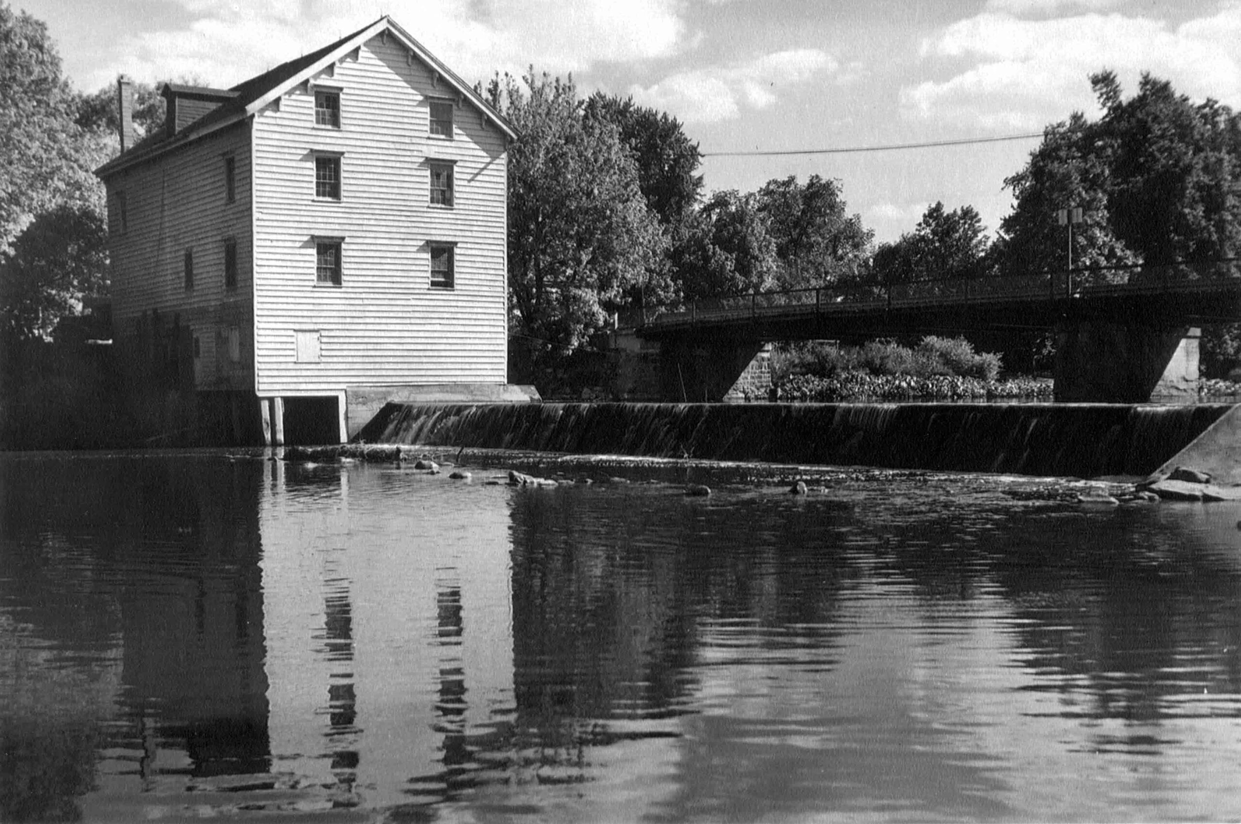
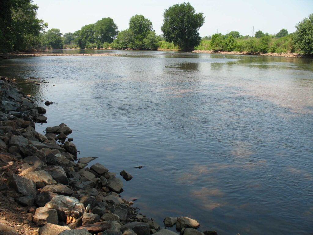
The Weston Mill Dam and the former Weston Mill gristmill and sawmill site are located approximately 1.5 miles upstream of the Millstone River’s confluence with the Raritan River, and immediately downstream of the Weston Causeway (Wilhousky Street) Bridge in the Borough of Manville and the Township of Franklin, Somerset County, New Jersey. The dam crest length was approximately 112.5 feet long and there was a concrete approach apron that ranged in thickness from 5 to 6.75-inches that extended 17.5 to 18.5 feet upriver of the dam spillway. The location of the mill was depicted on early Colonial-era and Revolutionary War military field maps, and the mill and dam were picturesque landmarks that were often photographed by local residents, including images included in the book Franklin Township [NJ] – Images of America, published in 1997.
Weston Mill Post-1948 to Early 1960s, Photographer Unknown
Through an intensive deed search, I determined that a gristmill and dam were established on the east bank of the Millstone River at the project area circa 1747, most probably built by Abraham Brokaw, and the mill was subsequently involved in a Revolutionary “Forage War” skirmish between British and American forces on January 20, 1777 while under the ownership of Abraham Van Nest. Recovery of two cornerstones during 1983 salvage operations suggest major mill building and rebuilding efforts occurred in 1803 and 1844 by John M. Bayard and Isaac R. Cornell, respectively. Though the mill remained active at this site into the early twentieth century (it was the most productive mill in the Millstone River/Stony Brook drainage), under various private owners and incorporations (Weston Mill Company, Inc.; Community Flour Mill and Grain Company; Union Mills Company, Inc.), and the dam underwent significant structural repairs between circa 1922 and circa 1948 by its last owner (Wilbur Smith), it ultimately fell into disuse and disrepair. On May 31, 1982, the mill building partially collapsed into the Millstone River. Mill artifact salvage operations were initiated on June 25, 1983 but were abandoned when arson claimed the collapsed structure on July 7, 1983.
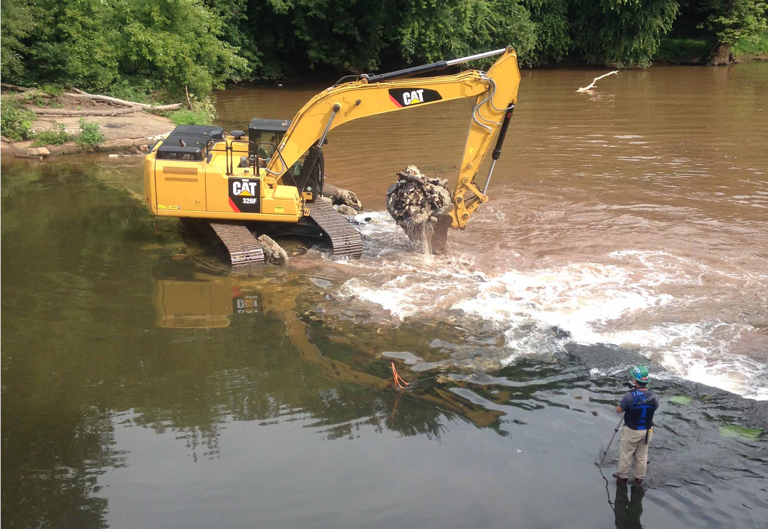
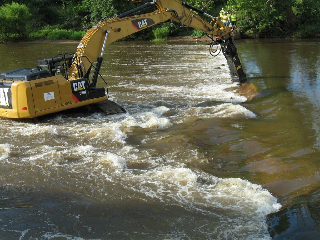
Weston Mill Dam Initial Breach, Photo: Charles Kahler, PE
Weston Mill Initial Breach, Photo: John W. Jengo, PG
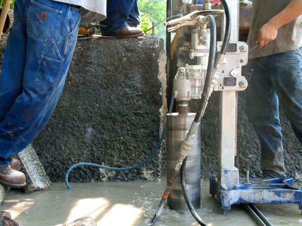
When I first began assessing this dam in 2009 as a candidate for removal, the Weston Mill site included the brownstone and concrete foundation remains of a gristmill that had enclosed a turbine room (formerly the water wheel pit) and a tailrace room, and there were associated powertrain components scattered throughout the site, including multiple bevel gears, possible mortise and pin gears, sprocket gears, drive shafts, counter shafts, flat belt pulleys, and other mill-related power-train apparatuses. A concrete coring project conducted in August 2015 at five representative locations on the dam approach apron (the same effort that determined the thickness of the apron) revealed two concrete approach aprons, which suggested that the dam was reinforced or rebuilt with concrete in two different periods in the early- to mid-twentieth century and that this run-of-the-river dam may have been built on top of a timber crib dam of unknown age.
Routine visits to the dam site over the next eight years would indicate that beginning in 2015, the eastern 78 feet of the dam crest (i.e., the top of the spillway) and spillway began to noticeably subside and detach from the concrete approach apron, placing undue stress on the riverward mill foundation wall to the east. By mid-2017, the collapsing dam crest and spillway had subsided almost to the level of the downstream pool elevation, had deflected outward some five feet downriver, and in doing so, the flow of the river was redirected toward the mill ruins on the east bank, potentially causing adverse effects to the mill foundation and complicating the dam removal.
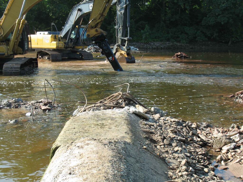
The dam removal and the engineering plans were re-designed to include emplacing scour protection around the Weston Mill foundation walls to arrest the damage to the ruins and preserve the remaining fabric of the site for future study. The first step in the dam removal process, which commenced on August 14, 2017, was to initially breach a portion of the dam to reduce the differential head between the upstream and downstream pools. The initial breach width of 35 feet, located near the center point of the dam, produced the desired upstream pool drawdown and a relatively low current velocity through the breach. Once the upstream impoundment had drained, the contact between the concrete approach apron and the riverward mill foundation wall was accessible to be saw cut to isolate the apron from the mill wall prior to further demolition. This was done to ensure that neither the weight of the demolition excavator or the vibration of the hydraulic hammer would destabilize the riverward foundation wall.
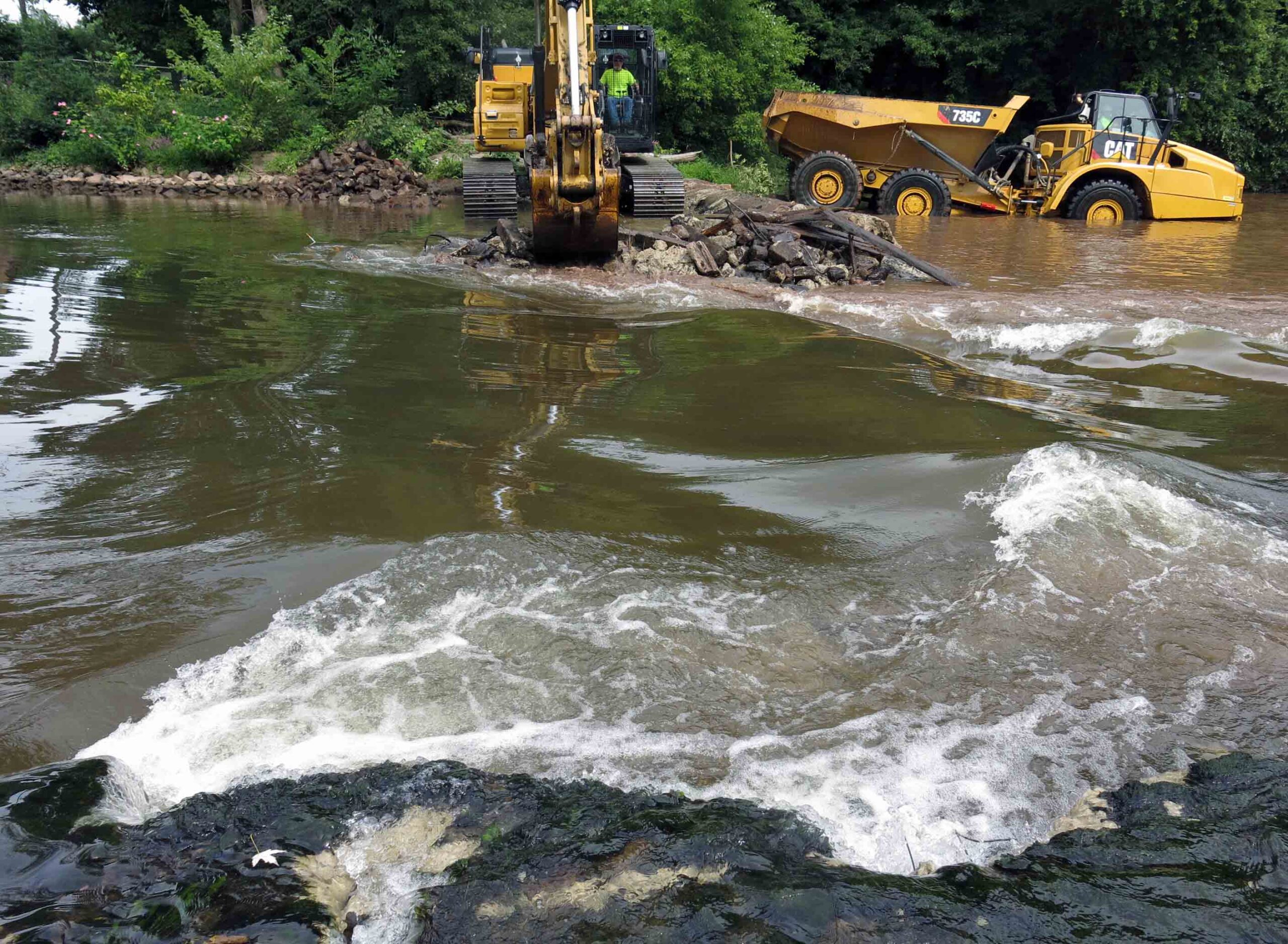
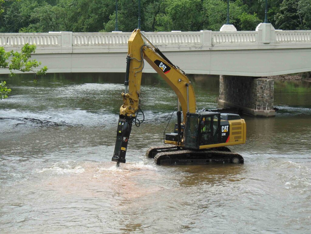
Weston Mill Dam Spillway Removal, Photo: John W. Jengo, PG
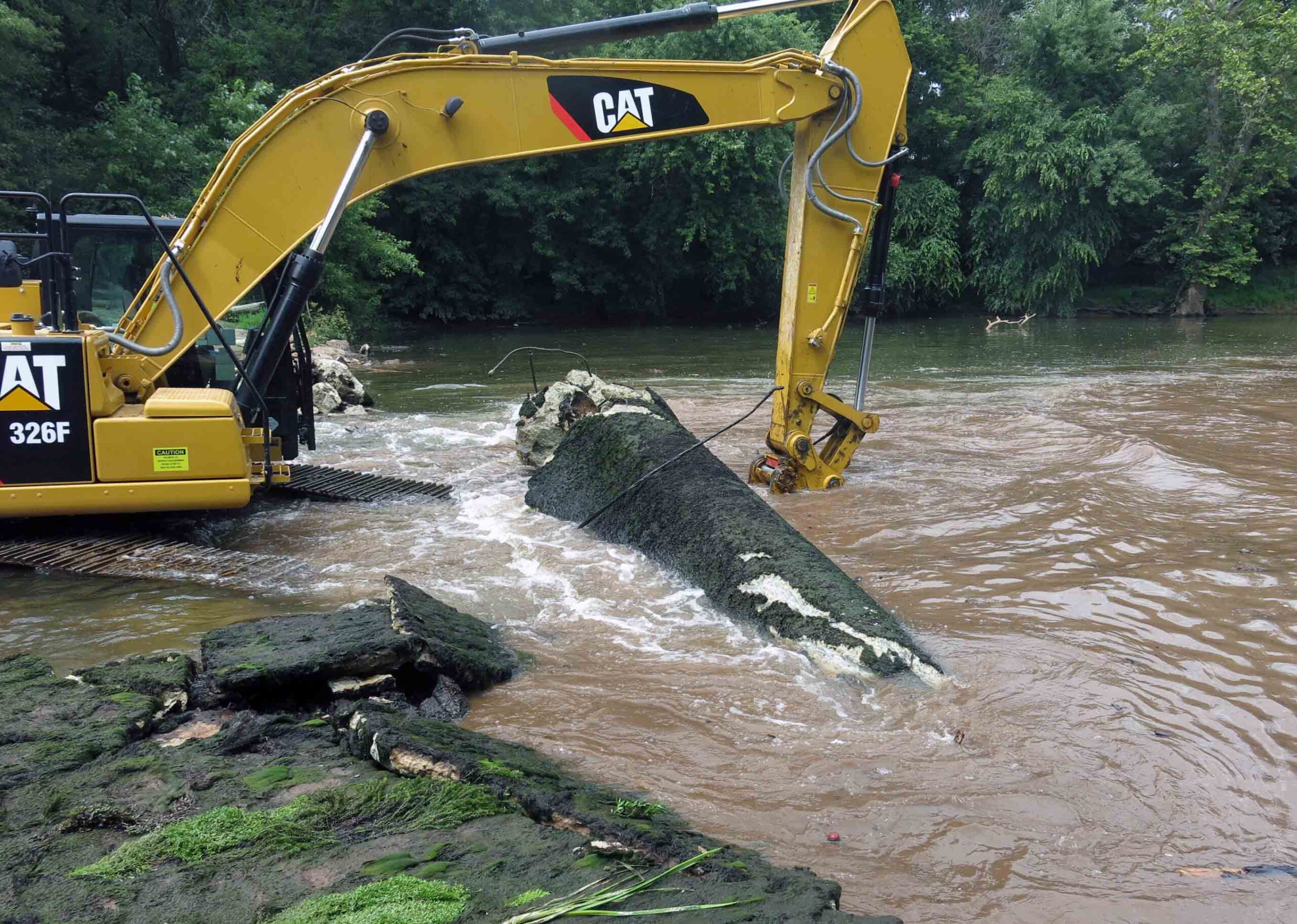
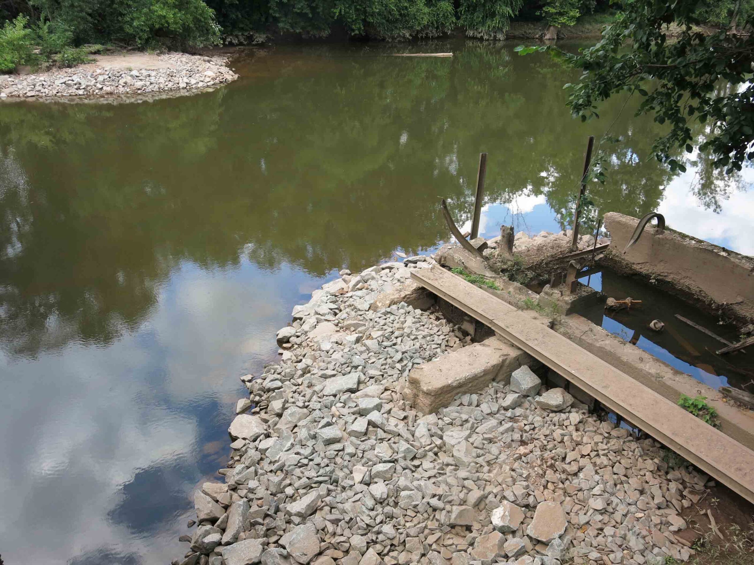
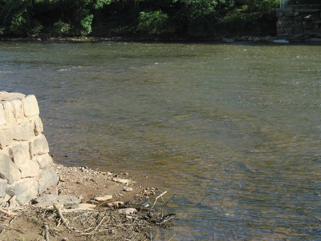
After the saw cut was completed, the concrete approach apron, an underlying concrete sub-apron, and dam spillway were carefully detached and removed. Imported rip rap was then emplaced around the mill foundation walls. My experience working on the rivers of this watershed indicated that natural sedimentation from storm events would eventually blanket and in-fill the rip rap, enhancing the stability of the scour protection armament. Finally, a restored river channel thalweg were excavated and contoured appropriately. It was during these excavations that segments of a timber crib dam, secured to the river bed by using 17.5-inch to 20.5-inch long, 1.125-inch square iron spikes, were extracted that clearly indicated that the pre-concrete dam structure was a timber crib construction. Three primary types of roughly square timbers believed to be part of the timber crib dam were identified: 13-foot long lap jointed foundation logs with iron spikes, 9.25- to 9.75-foot timbers with two mortise joints (some with intact dowels), and 3.8-foot timbers with tenons at one end. Several timbers of this historical structure were saved and donated to the Borough of Manville, Delaware and Raritan Canal State Park, and NJDEP, who had purchased the dam site in 2013 from a private owner, an acquisition that allowed the dam removal to proceed.
Weston Mill Dam Post Removal, Photo: John W. Jengo, PG
Monitoring of the river reach above the former Weston Mill Dam in spring 2018 following the August 2017 dam removal found definitive evidence of successful American shad spawning, an astonishing and long-awaited result given this river reach had effectively been blocked to migratory fish for over 270 years. Five juvenile shad averaging 4.3 inches in length were found 4.5 miles upstream of the dam at the base of Blackwells Mills Dam during a monitoring visit, highlighting yet again the dam removals can yield near-instantaneous positive results even after centuries of impeding fish migration and spawning.
Video of the Weston Mill Dam removal can be viewed here:
Endnote: Because of the archaeological discoveries made before and during the dam removal, and the rich cultural history of Weston Mill, a standalone video on the History of Weston Mill was developed and can be viewed here:
John W. Jengo, PG, LSRP is a licensed Professional Geologist in several Northeastern and Southeastern states and a Licensed Site Remediation Professional in New Jersey. John works as a Principal Hydrogeologist in an environmental consulting firm in southeastern Pennsylvania. He has degrees in geology from Rutgers University (1980) and the University of Delaware (1982). Over the last 30 years, he has conducted the characterization and remediation of large, complex contaminated industrial sites throughout New Jersey, Pennsylvania, and Delaware. He played a key role in Natural Resource Damage (NRD) assessments that led to groundbreaking legal settlements to remove numerous low head dams on the Raritan and Millstone Rivers to restore historically significant migratory fish spawning runs. As technical project manager, he planned, permitted, and successfully managed the removal of the Calco Dam, the Robert Street Dam, and the Nevius Street Dam between 2008-2013, and the removal of the Weston Mill Dam on the Millstone River in 2017, along with leading the archaeological investigation of the former Weston Mill in the Borough of Manville and Franklin Township.
We are proud to announce that the LRWP is a partner organization for Windows of Understanding 2021, a public art project rooted in social justice, opening to the public on Mon, January 18.
Our wonderful 2021 Windows of Understanding artist Marcia Shiffmann has created two beautiful and unique art images that will be displayed in separate windows at the Taco House in downtown New Brunswick (located at 115 French Street, New Brunswick NJ 08901). The LRWP will feature an interview with Marcia and highlight more about her work in our February newsletter. For now, please read Marcia’s artist statements for each of these Windows Of Understanding images.
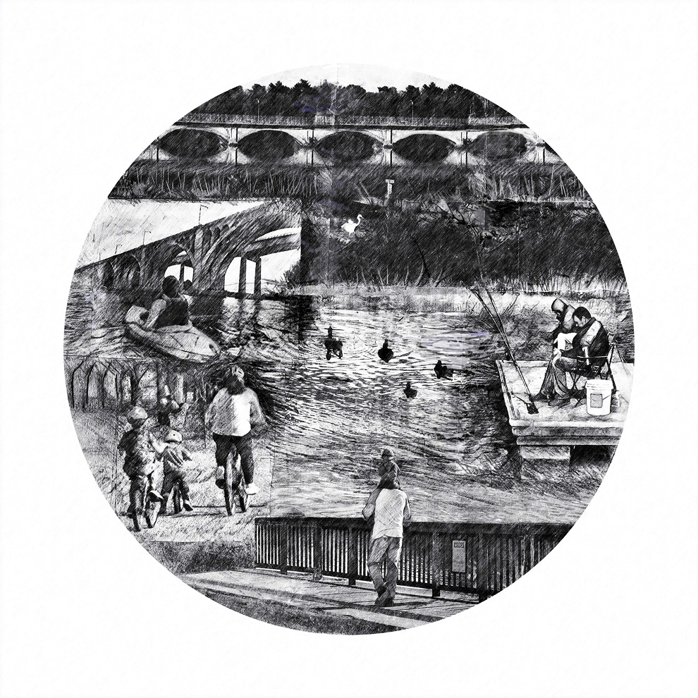
“Along the Raritan”
The Raritan River is important for our community. Providing equitable and safe links to the Raritan will ensure that it can be experienced by all. It provides diverse opportunities to engage in nature and recreation with fishing, boating, walking, hiking, biking and other outdoor activities. We must work to protect and sustain this resource for current and future generations. This piece shows illustrates some of the many ways our community currently enjoys the Raritan as a valuable open space resource. It also support wildlife as shown by the images of the Great Egret and fishes in their riverine habitat.
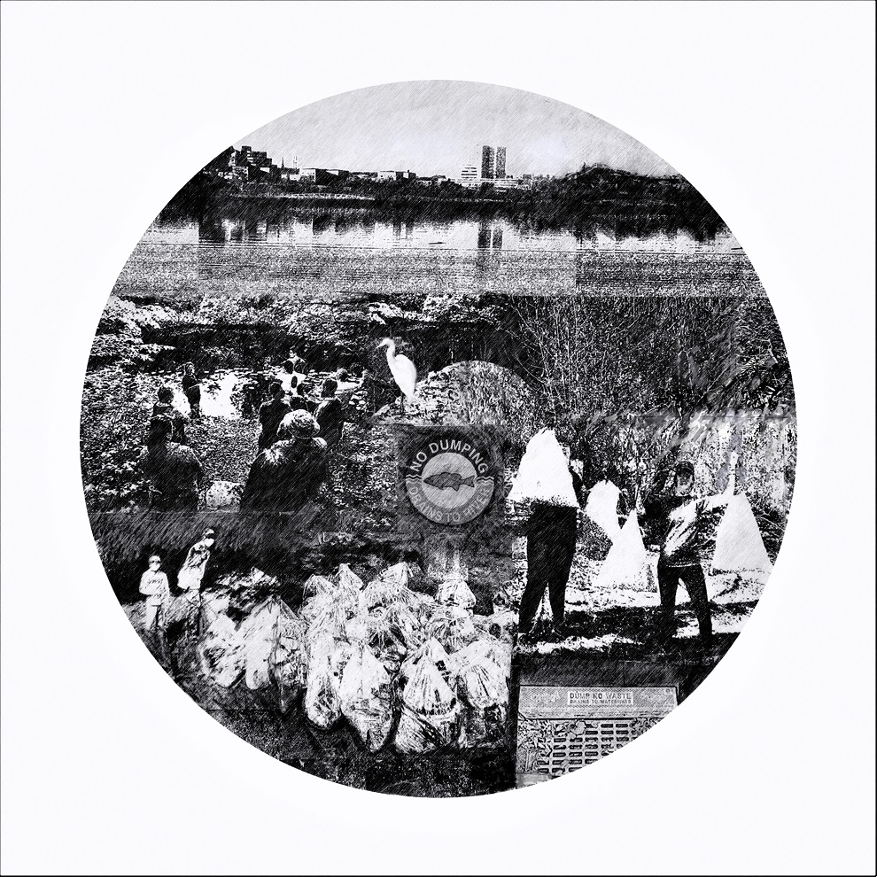
“Keeping the Raritan Healthy”
The Raritan River provides many benefits to our community as a valuable open space resource. This piece shows many of the stewardship activities of the Lower Raritan Watershed Partnership. These include an active river clean-up program, water quality testing, many citizen scientist volunteers and supportive partners. The “No Dumping” signs illustrate that all water eventually drains to the river. Clean water supports food safety to promote safe fishing. Volunteers engage in the clean-up campaigns sustaining clean land and water. Clean water supports wildlife, as exemplified the Great Egret found along the Raritan. We need to carefully protect this important resource.
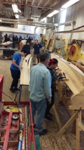
The LRWP’s new “Rowing on the Raritan Boat Building Project” seeks volunteers to participate in boat-building to provide the inaugural fleet of a community-based rowing program on the Raritan River. The goal is to construct two cedar strip rowing boats during a 90-day building period beginning the week of January 24, 2021. No experience required. Volunteers will have the opportunity to learn through hands-on activities, as well as through live-streaming and recorded instructional sessions.
We are now taking registrations for our “soft” launch the week of January 25. Each time slot is limited to four (4) participants. Boat build activities will take place at 100 Kirkpatrick Street in New Brunswick, NJ (the former Fresh Grocer site across from the New Brunswick train station). Feel free to participate as “observer” – watch our volunteers build the boats via street-level windows.
Requirements for Participation:
Age 14+
No boat-building experience required
Free to register and participate
Participants will be screened at the beginning of each shop session and expected to follow Covid-19 Safety Protocol.
With thanks to Derek Hartwick-Head Rowing Coach- U.S. Merchant Marine Academy, and the New Brunswick Parking Authority for their partnership on this project.
The eternal cosmic clock, rewound by the choreographed dance of celestial bodies, precisely marks the rebirth of light and the start of winter.
The runway for January’s landing is lit nine days before, during the winter solstice. The lights grow brighter as the spinning earth tilts in relation to the sun. This delicate earthly pirouette is anything but a solo performance. Only in a state of cosmic equilibrium, held firmly in place by gravity, can the possibility of life occur.
The relative stability of atmosphere and repetitious seasonal changes found on earth, provide the predictability and time, life requires to evolve and adapt.
While the January first rewind is a human convenience, all life forms, humans included, have evolved to key in on the periodicity of increasing and decreasing day length. Light, along with atmosphere, temperature, and gravity dictate the detailed specifications that must be met to exist. Life on the other hand, has no bargaining power and must somehow develop a form that embraces all the requirements set forth by the cosmic design as found on earth.
Successful adaptation is critically dependent on the stability of environmental conditions. Life forms whose ability to adapt, lags behind the speed of change, simply go away. The constant effort to achieve existence, results in an almost infinite variety of life, whether it be a blade of grass or an elephant. Each develops unique mechanisms to deal with seasonal changes in atmosphere and light. New life forms are constantly being discovered while other life forms go extinct.
I find it amazing our existence depends on heavenly bodies, light years away, hurtling through space in well-choreographed orbits controlled by gravity. Even more amazing is how oblivious humanity is to its existential condition, hanging only by an invisible thread. Though cosmic events are out of our control, its link to our existence sparks imagination and wonder. The curiosity that arises when we look toward the heavens has a gravity of its own which draws us in to seek deeper knowledge. Imagination and creativity are set afire when faced with a gap in information. We are compelled to temporarily bridge the unknown with subjective theory, a vestige of our innate survival skills.
As humans we are surrounded by natural wonders whose intended or unintended purpose is to fire our imagination and fuel our creativity to enhance our survival. In that way nature is teaching us how to fish as well as providing our daily bread.
Wise words spoke of rendering to Caesar and following that advice we celebrate January first as a nod to society. Let us also be inspired by the brightness of January traced back to the winter solstice and that moment of perfect equilibrium between light and darkness. A celebration of the moment life began to stir on a planet spinning in the blackness of an infinite universe bounded only by our imagination.
Author Joe Mish has been running wild in New Jersey since childhood when he found ways to escape his mother’s watchful eyes. He continues to trek the swamps, rivers and thickets seeking to share, with the residents and visitors, all of the state’s natural beauty hidden within full view. To read more of his writing and view more of his gorgeous photographs visit Winter Bear Rising, his wordpress blog. Joe’s series “Nature on the Raritan, Hidden in Plain View” runs monthly as part of the LRWP “Voices of the Watershed” series. Writing and photos used with permission from the author. Contact jjmish57@msn.com. See more articles and photos at winterbearrising.wordpress.com.
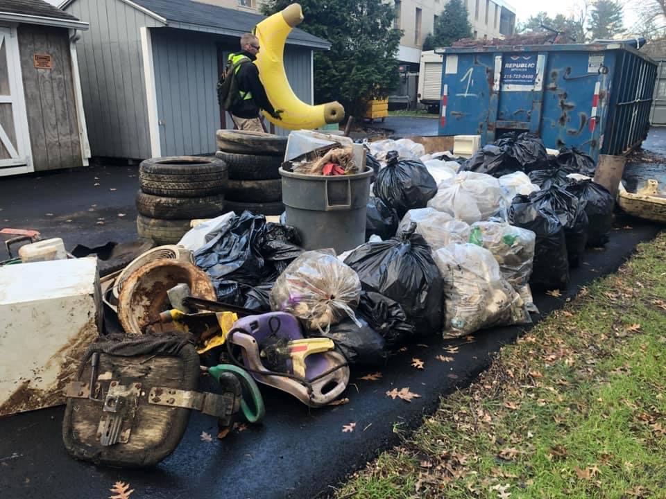
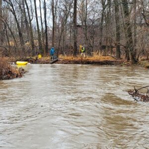
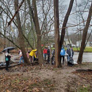
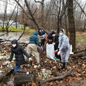
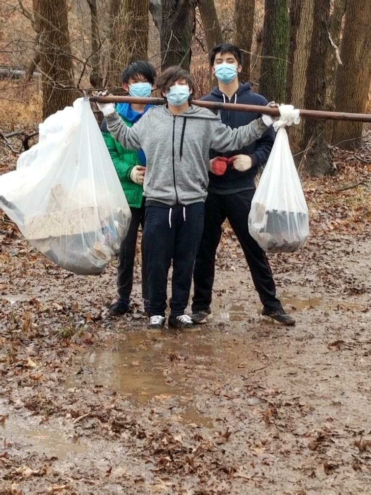
HUGE THANKS to the 60+ intrepid souls who joined the Lower Raritan Watershed Partnership and Central Jersey Stream Team out on the Green Brook floodplain for our last clean-up of the year. It was a cold, windy, rainy, mucky start to the day – really only the cold abated by the time we wrapped up.
With appreciation to Green Brook Township, Green Brook Regional Centre, GreenBrook Lions, Sewa Central Jersey, Mr. Kevin Ellis’ Middle School Science class, our Hackensack Riverkeeper friends and all the wonderful volunteers for giving of their time to clean up our watershed!
A crazy amount of trash was collected including a mini fridge, large screen TV, a big inflatable banana and so much more. See below for a few photos from the day. See you in 2021!!
LRWP board member Anton Getz and CJST board member Jens Riedel spot an inflatable banana on the Green Brook
Green Brook Middle School science teacher Kevin Ellis and his students
Central Jersey Sewa volunteer fill dozens of bags with plastic bottles
Dams are devastating to our stream systems and watersheds. They fragment our riverine habitat with cascading impacts including reservoir sedimentation, channel degradation, water quality effects, and blockage of fish migrations. Socioeconomic and cultural effects include loss of homes and livelihood, compromised access for recreation, concentration of heavy metals in the food chain, hydraulic undertows and drowning risks, and the potential for dam failure.
Dam removal takes a big picture view of River restoration, advancing an approach that prioritizes restoring the rivers’ ability to create, retain, manage, and reconnect watershed habitats, rather than man made attempts to direct flow or artificially create habitats.
It would be hard to find anyone who has advanced a clearer vision for a restored Raritan and improved watershed habitat connectivity than hydrogeologist John W. Jengo, PG, LRSP. John, a licensed Professional Geologist in several Northeastern and Southeastern states and a Licensed Site Remediation Professional in New Jersey, works as a Principal Hydrogeologist in an environmental consulting firm in southeastern Pennsylvania.
Over the last 30 years John has drawn on degrees in geology from Rutgers University (1980) and the University of Delaware (1982) to conduct the characterization and remediation of large, complex contaminated industrial sites throughout New Jersey, Pennsylvania, and Delaware. He played a key role in Natural Resource Damage (NRD) assessments that led to groundbreaking legal settlements to remove numerous low head dams on the Raritan and Millstone Rivers to restore historically significant migratory fish spawning runs. As technical project manager, he planned, permitted, and successfully managed the removal of the Calco Dam, the Robert Street Dam, and the Nevius Street Dam between 2008-2013, and the removal of the Weston Mill Dam on the Millstone River in 2017, along with leading the archaeological investigation of the former Weston Mill in the Borough of Manville and Franklin Township.
The Lower Raritan Watershed Partnership thanks John for developing a blog series that provides a history of five of the dams in the Raritan Basin, the problems they have caused, and the process of their removal. In this series of posts about the Calco, Nevius, Robert Street, Headgates and Westons Mill dams, John highlights his big picture view of restoration: reconnecting the Raritan River habitat.
Click on the links below to read John’s story of dams and dam removal on the Raritan Basin.
By Carolyn Lange, Community Foundation of New Jersey, reprinted with permission
The coronavirus has changed all our lives, but for many this year has been nothing short of devastating. Fortunately, the federal government has added new tax rules so individuals who have a little extra are encouraged to help those who are less fortunate. The new rules provide expanded benefits for New Jerseyans to give to their favorite causes, providing a much-needed boost to hard-hit communities and the non-profits that serve them.
The Coronavirus Aid, Relief, and Economic Security Act, or CARES Act, creates rare giving incentives for taxpayers at both ends of the income scale, with an eye toward addressing our communities’ challenges.
Individuals who do not itemize their taxes (a larger group than in past years given the doubling of the standard deduction to $12,000 for individuals and $24,000 for those filing jointly) will be able to deduct charitable contributions for the first time in 40 years. This deduction is limited to $300 for individual taxpayers and $600 for households filing jointly. Nearly 80% of taxpayers take the standard deduction so this new incentive is available to an enormous pool of potential donors.
Individuals who itemize deductions and seek to deduct as much as possible from their adjusted gross income (AGI) can now deduct up to 100% of their AGI. In past years, donors could only deduct 60% of their AGI through cash contributions to public charities; for 2020, that limit was raised to 100%.
Donating long-term appreciated securities or distributions from an IRA remain popular and effective options for reducing one’s overall tax burden while creating new philanthropy, though the rules associated with such gifts were not materially changed by the CARES Act. Donors who have realized significant capital gains, whether through stock, bonds, or real estate, are still subject to deduction limitations and should consult their financial and tax advisors.
The new tax rules relating to charitable giving from the CARES Act could not have come at a more critical time. We encourage all New Jersey residents who feel fortunate this year to reach out and give to those who need it most by supporting the hard-working organizations serving our communities and neighbors in this challenging time.
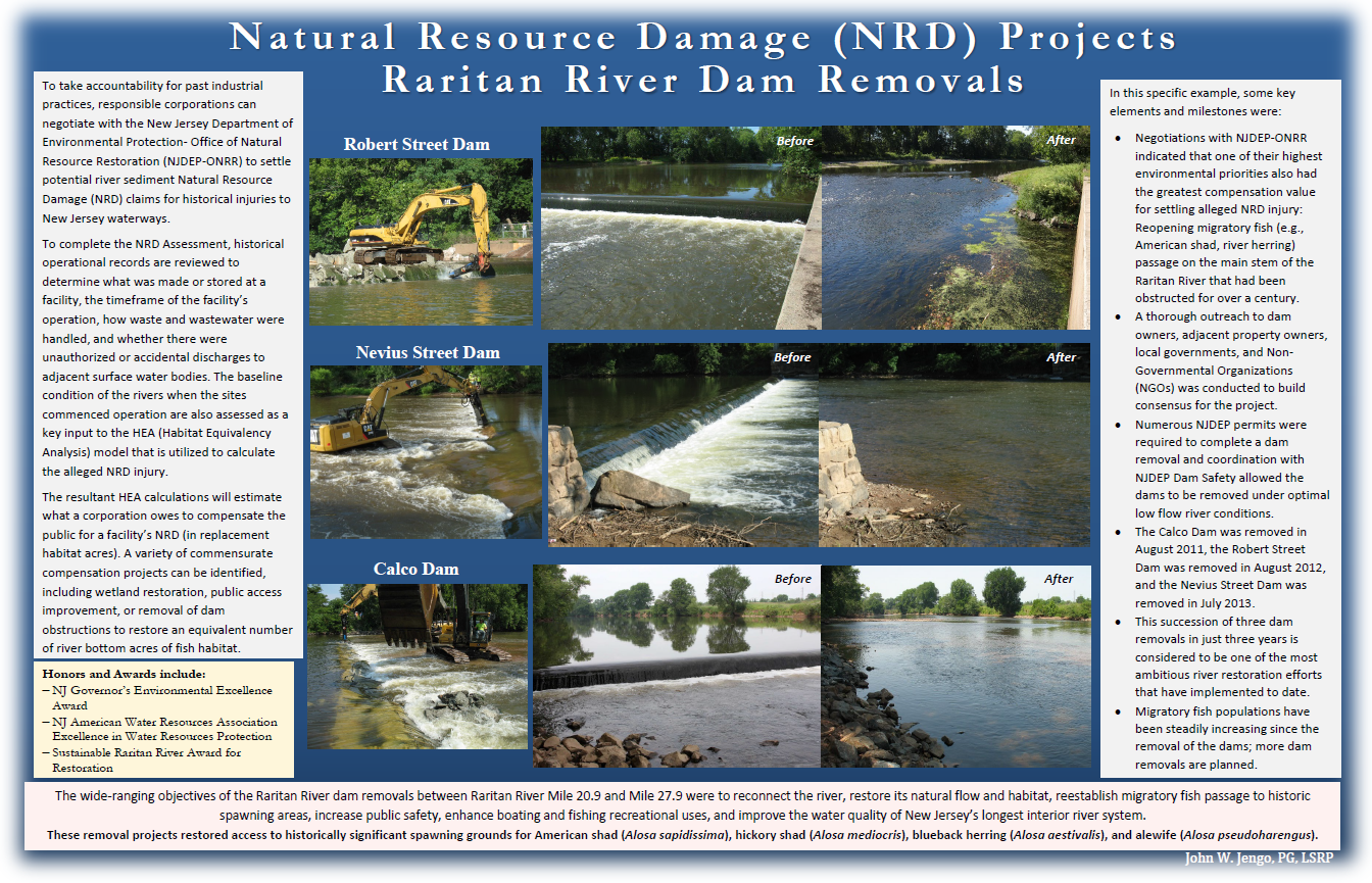
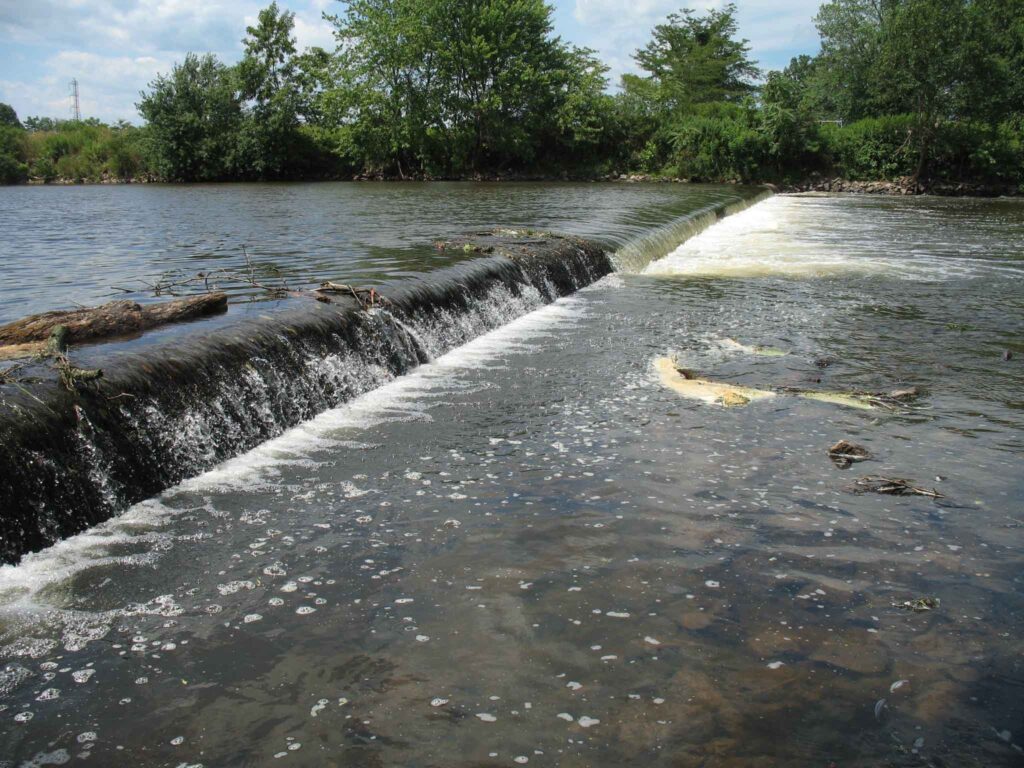
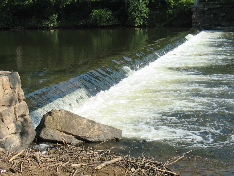
Calco Dam, positioned at Raritan River Mile (RM) 20.9, was located in Bridgewater and Franklin Townships, Somerset County, New Jersey just upriver from the Borough of Bound Brook. Calco Dam, technically a low-head loss dispersant weir, was constructed in 1938 by the Calco Chemical Company, Inc. as part of the effluent conveyance system for a synthetic dyestuff manufacturing operation that had been established at this location in 1915. To direct effluent flow to Calco Dam, a diversion structure was built on a natural stream (Cuckels Brook) 800 feet north of the dam, and as part of the diversion construction, a canal was dug from that structure to Calco Dam; a screening structure was installed at the end of the canal to prevent debris from flowing into the dispersant pipe inside the dam. The center dispersant weir section of Calco Dam was 123 feet long and was composed of a 36-inch-diameter effluent tile pipe encased in concrete, which had on its downstream side a total of 41 8-inch-diameter outlets spaced three feet apart. The weir structure was connected to the river banks by approximately 50- to 55-foot-long solid concrete abutments, making Calco Dam a run-of-the-river structure. According to the original design drawings, Calco Dam varied in width between 21.25-23 feet and it had a structural height of approximately seven feet. There was an 18-inch-thick, 12-foot-wide concrete apron extending downstream from the dam crest, ending in an apron toe section extending 3 feet below the river bed.
Calco Dam Before Removal
When the Somerset Raritan Valley Sewerage Authority (SRVSA) purchased the manufacturing site’s wastewater treatment plant operations in 1985, ownership of Calco Dam also transferred to SRVSA because the dam was an integral part of the facility wastewater effluent discharge system. Although SRVSA was utilizing Calco Dam for discharging treated municipal effluent into the Raritan River when I approached them in 2008 about removing the dam, they were already in the process of designing and permitting an alternative effluent discharge route and outfall to the Raritan River, which would allow Calco Dam to be abandoned and removed. SRVSA immediately recognized the value of eliminating the potential liability of a dam and they became the model of a cooperative dam owner in the subsequent contractual negotiations to grant us permission to remove Calco Dam.
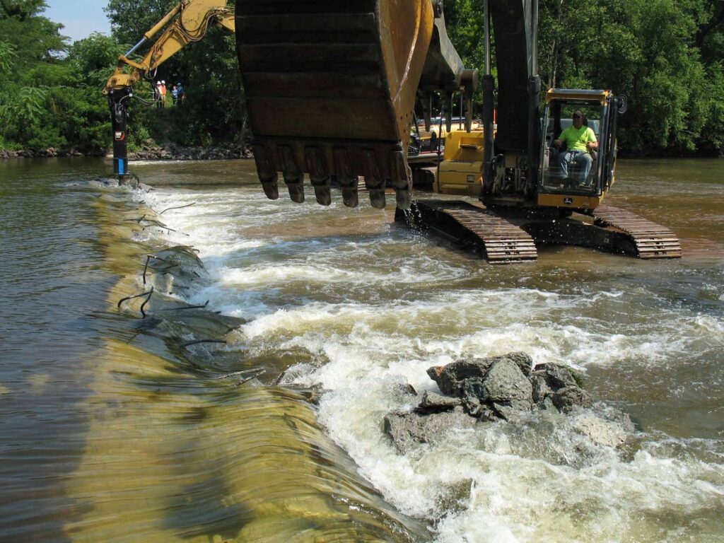
The Calco Dam removal was successfully accomplished between July 18 and August 1, 2011, but the removal had an unique engineering component. In planning the dam removal, I ascertained that the southernmost end of the dam had been incorporated into and under the towpath berm of the historic Delaware and Raritan (D&R) Canal, although a fair portion of this dam section had been subsequently exposed by scour eddies caused by water flowing over the dam. The effect of any further excavation on the stability of the D&R Canal towpath berm was considered too risky to implement so a decision was to made to leave that southernmost section of the dam intact and rebury the section that had become exposed from the river’s scouring action. To isolate this dam section from the remainder of the structure that was to be removed required that a methodology be devised to cut through the entire dam structure with a minimal amount of disturbance to the towpath berm (the dam was much too thick to be saw cut). Taking advantage of the same scour pool that had dangerously eroded into the base of the towpath berm, we built a temporary coffer dam around this section of the dam, dewatered it, and proceeded to drill and extract dozens of overlapping 6.5-inch diameter concrete cores across the width of the dam in the process known as “stitch coring.” Once the isolation of this section of the dam was completed, we imported tons of properly-sized rock riprap and rebuilt the base of the D&R Canal towpath berm back into its original configuration with the southernmost dam fragment now serving as a stable foundation for the reconstruction. Success of this restoration was tested just a few weeks later during back-to-back record flooding events from Hurricane Irene and Tropical Storm Lee when this section of the repaired D&R Canal towpath berm held firm while other sections along the D&R Canal route suffered washouts and breaches.
Calco Dam During Initial BreachingCalco Dam During Final BreachingCalco Dam Stitch Coring
The number of returning migratory fish in the Raritan River the following spring heralded the remarkable and rapid recovery of the Raritan River at the Calco Dam location. Based on observations at the upstream Island Farm Weir (IFW) fish ladder viewing window in the first spring migration season (March-May 2012) following the dam removal, the number of American shad migrating upstream increased 500% and the total number of fish passing through the IFW fish ladder increased by 200%. This essentially instantaneous result propelled the planning of the next two dam removals, which were accomplished in just the next two years (Robert Street Dam in 2012 and the Nevius Street Dam in 2013), and this succession of three dam removals in just three years is considered to be one of the most ambitious river restoration efforts that have implemented to date.
Calco Dam After Removal
John W. Jengo, PG, LSRP is a licensed Professional Geologist in several Northeastern and Southeastern states and a Licensed Site Remediation Professional in New Jersey. John works as a Principal Hydrogeologist in an environmental consulting firm in southeastern Pennsylvania. He has degrees in geology from Rutgers University (1980) and the University of Delaware (1982). Over the last 30 years, he has conducted the characterization and remediation of large, complex contaminated industrial sites throughout New Jersey, Pennsylvania, and Delaware. He played a key role in Natural Resource Damage (NRD) assessments that led to groundbreaking legal settlements to remove numerous low head dams on the Raritan and Millstone Rivers to restore historically significant migratory fish spawning runs. As technical project manager, he planned, permitted, and successfully managed the removal of the Calco Dam, the Robert Street Dam, and the Nevius Street Dam between 2008-2013, and the removal of the Weston Mill Dam on the Millstone River in 2017, along with leading the archaeological investigation of the former Weston Mill in the Borough of Manville and Franklin Township.
Yesterday was the last day of pathogens monitoring for 2020. Despite COVID-related challenges and the general difficulties of juggling an all volunteer program, we met EPA requirements for quality data and built a great data set. HUGE THANKS to our partners: Rutgers Cooperative Extension of Middlesex County and the Interstate Environmental Commission. And much gratitude to all our wonderful volunteer monitors! We couldn’t do it without you!
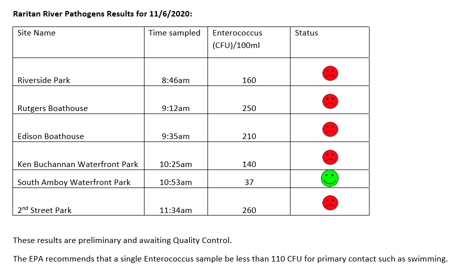
Below are our pathogens results for 11.5.2020, followed by field notes for the day.
The LRWP and Rutgers Cooperative Extension of Middlesex County monitor for Fecal Coliform and Enterococcus at six non-swimming public beach access sites along the Lower Raritan during the warmer summer months. Fecal Coliform and Enterococcus are indicators of disease-causing bacteria in our waterways.
The EPA recommends that a single Enterococcus sample be less than 110 Colony Forming Units (CFU)/100mL for primary contact. Enterococci levels are used as indicators of the possible presence of disease-causing bacteria in recreational waters. Such pathogens may pose health risks to people fishing and swimming in a water body. Sources of bacteria include Combined Sewer Overflows (CSOs), improperly functioning wastewater treatment plants, stormwater runoff, leaking septic systems, animal carcasses, and runoff from manure storage areas. Enterococci levels are often high after heavy or consistent rainfall.
Field notes for November 5, 2020
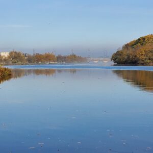
Another foggy start to the morning. Both our Riverside Park (Piscataway) and New Brunswick Boat House sites were gorgeous under a shroud of mist.
Looking toward Albany Street Bridge from the Rutgers Class of 1914 Boathouse
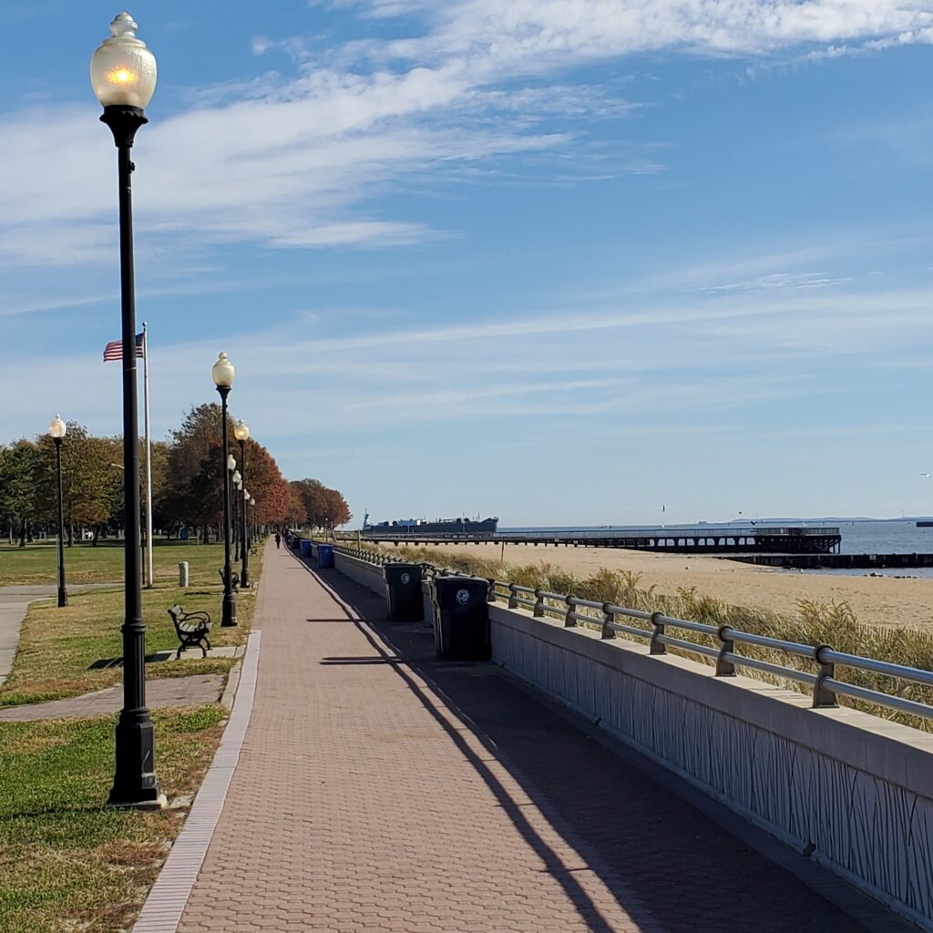
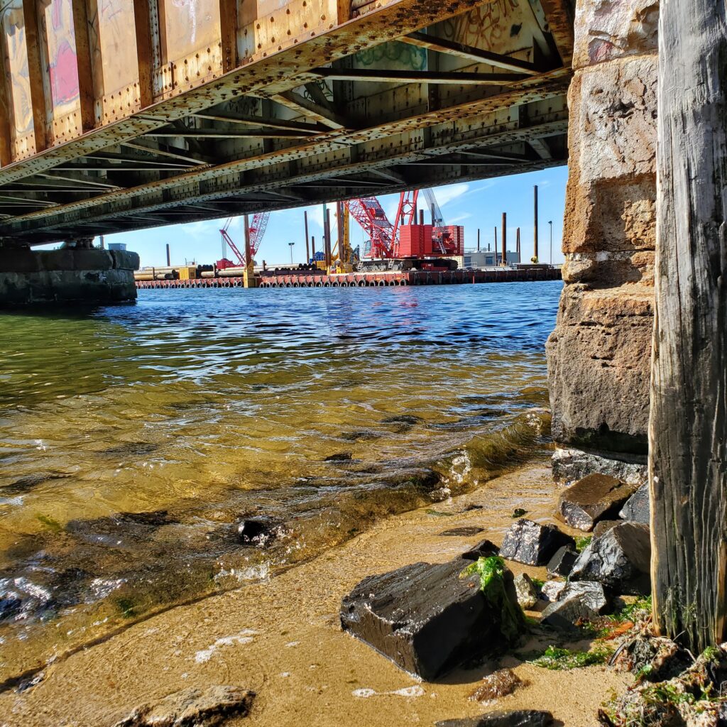
The views from our monitoring site in Perth Amboy are dramatic. To the left you look out to Raritan Bay and sailboats and huge ships heading into New York Harbor. To the right you look upstream, at the mouth of the Raritan, where the new “River Draw” train bridge is under construction.
Looking toward construction of the new train bridge from under the old “River Draw”
So long, see you next year!
While it is sad to end the sampling season, we will be happy to empty our trunk of monitoring supplies
The Nevius Street Dam at Raritan River Mile 27.0 was located just south of the Borough of Raritan, Somerset County, New Jersey. This dam, also referred to as the “Duke Dam,” was constructed in 1901 by James Buchanan (Buck) Duke, the tobacco and hydropower industrialist, for aesthetic and recreational purposes as part of his development of Duke Farms, a 2,740-acre estate in Hillsborough Township, New Jersey. Careful examination of the dam indicated that it was constructed of dressed stone blocks arranged in a stair-step fashion set into a concrete core foundation that was 195 feet long, approximately 2.5 feet high from sill to crest, and approximately 6.5 feet in width. The picturesque dam and dam impoundment were often photographed in its early years, and some of these photographs were reproduced in the book Raritan [NJ] – Images of America, published in 2003.
The Nevius Street Dam was subsequently converted into an essential part of the Duke Farms water supply system when water pumping withdrawals from the adjacent Raritan Water Power Canal were discontinued in the early 1970s (this Canal water supply system was the original source of water that was pumped up to Duke Farms for irrigation and for circulation through a series of man-made lakes and waterfalls). This conversion was accomplished by retrofitting a water intake grate on the north side of the dam, and installing a 205-foot long, 30-inch diameter concrete reinforced pipeline that conveyed surface water downriver into a subterranean chamber under the Duke Farms Powerhouse building, which was then pumped up to the Duke Farms reservoir (from there, the water cascaded through the numerous lakes and waterfalls on the property). This modification allowed Duke Farms to utilize the same infrastructure that had previously provided both hydroelectric power and water supply to the property, although now that the surface water was flowing into the river-level penstock of the Powerhouse rather than falling from a substantial height from the Raritan Water Power Canal, the turbines of the Powerhouse were bypassed and, thus, fell silent.
In the runup to its removal, the Nevius Street Dam was still providing a vital service and with the pending removal of the dam, Duke Farms would be without a water supply for their renowned lake system. As part of the arrangement to remove the dam, I performed a hydrogeological study at the property in 2012 to determine if new groundwater supply wells could be installed to replace the Raritan River surface water supply. This alternative proved to be feasible, although it would not be possible to replace the approximately 750,000 to 1 million gallons that was typically pumped up to the Duke Farms reservoir each day. The tradeoff of a lower volume of groundwater was that the groundwater would be free of high concentrations of total phosphorus, ammonia-N, and nitrate-N that are present in the Raritan River, an impairment caused by runoff of fertilizer and manure from agricultural fields, suburban lawns, and golf courses. The Duke Farms Natural Resources team were expectant that the introduction of groundwater without excess nutrients might curtail the growth of curly-leaf pondweed and filamentous mat algae that has afflicted the lakes in the modern era.
The installation of two groundwater water supply production wells was conducted in 2012 and 2016 and befitting Duke Farms’ commitment to the concept of “adaptive reuse,” I and the Duke Farms team conceived of a plan to repurpose underground pipelines that were built in 1909-1910 to connect the new production wells to the reservoir rather than excavate and install thousands of feet of new pipeline through the beautiful and pristine landscape of the property. Detailed analyses of an original 1911 as-built construction drawing revealed an elaborate underground pipeline network not only leading from the Powerhouse to the reservoir that the current dam pumping system was utilizing, but also a second, intertwined pipeline network that formerly conveyed water from a long-lost Recirculation Plant along the Raritan River that had recovered water after it had flowed through the lake system and recirculated it back to the reservoir. This pipeline was relocated in the field, flushed along its re-purposed length to remove accumulated sediment from its original operation, had its various values replaced, and was then connected to the new groundwater well field. This reconfiguration of the water supply system has proven to be a great success and it allowed for the removal of the Nevius Street Dam, which was accomplished between July 24-July 31, 2013.
Nevius Street Excavator – Initial BreachNevius Street Excavator – Final Breach
In closing, I would like to acknowledge former Executive Director Michael Catania, Jon Wagar (Deputy Director), and Thom Almendinger (Director of Natural Resources and AgroEcology), and the Doris Duke Charitable Foundation Board for their cooperation and consent to remove the Nevius Street Dam. Implementing this consequential water supply exchange from surface water to groundwater was not without risk so I am truly grateful for their trust, financial support, and steadfast resolve to implement this project, proving yet again that Duke Farms is a leader in environmental stewardship and an inspiration for citizens to become informed stewards of the land.
Nevius Street Dam After Removal
John W. Jengo, PG, LSRP is a licensed Professional Geologist in several Northeastern and Southeastern states and a Licensed Site Remediation Professional in New Jersey. John works as a Principal Hydrogeologist in an environmental consulting firm in southeastern Pennsylvania. He has degrees in geology from Rutgers University (1980) and the University of Delaware (1982). Over the last 30 years, he has conducted the characterization and remediation of large, complex contaminated industrial sites throughout New Jersey, Pennsylvania, and Delaware. He played a key role in Natural Resource Damage (NRD) assessments that led to groundbreaking legal settlements to remove numerous low head dams on the Raritan and Millstone Rivers to restore historically significant migratory fish spawning runs. As technical project manager, he planned, permitted, and successfully managed the removal of the Calco Dam, the Robert Street Dam, and the Nevius Street Dam between 2008-2013, and the removal of the Weston Mill Dam on the Millstone River in 2017, along with leading the archaeological investigation of the former Weston Mill in the Borough of Manville and Franklin Township.